La fotografia digitale è considerata un valido stru-mento per la documentazione del patrimonio cul-turale.
Topografia e fotogrammetria sono necessari per ottenere risultati metrici precisi nei disegni, mo-dellazione 2D/3D e texturing.
Questo articolo descrive il processo di lavoro adot-tato dall'acquisizione dati alla modellazione 3D fo-torealistica. Inoltre, sono documentati alcuni casi studio relativi a diversi siti.
I Manager e gli esperti di comunicazione sul pa-trimonio culturale, dovrebbero considerare la fo-togrammetria uno strumento non solo per arricchire la conoscenza, per migliorare la com-prensione e fornire registrazioni scientifiche, ma anche per facilitare la diffusione delle risorse del patrimonio.
Digital photography is considered a valuable tool for cultural heritage documentation. Surveying and photogrammetry are required to achieve me-tric and accurate results in drawings, 2D/3D mo-delling and texturing. This paper presents the photogrammetric workflow from data acquisition to photorealistic 3D modelling and four heritage documentation case studies in different sites. High resolution and high accuracy photorealistic 3D models allow experts to recreate and interact vir-tually with cultural heritage either before, during of after intervention. Managers and information experts of cultural heritage monuments and sites should consider photogrammetric by-products not only to enrich knowledge, improve understanding and provide scientific records but to ease dissemi-nation of heritage resources.
Parole chiave: beni culturali, documentazione,
fo-togrammetria, laser scanning, modello fotorealis-tico 3D
Keywords: cultural heritage, documentation, pho-togrammetry, laser scanning, photorealistic 3D models
Dalla fotografia digitale alla fotogrammetria per i Beni Culturali
Documentazione e Divulgazione
From Digital Photography to Photogrammetry for Cultural Heritage
Documentation and Dissemination
José Luis Lerma
Il dottor Lerma è un ingegnere e professore associato in Fotogrammetria presso l'Uni-versità Politecnica di Valencia (UPV). Egli è il Capo della Fotogrammetria e Laser Scan-ning Research Group (Gifle) presso l'UPV.. E' membro di numerosi comitati scientifici internazionali come CIPA e VSMM. Autore di sette libri riguardanti fotogrammetria e LiDAR.
Miriam Cabrelles
Ingegnere in Geodesia e Cartografia della UPV. Membro di GIFLE dal 2007. I suoi at-tuali campi di ricerca sono: rettifica delle immagini e calibrazione di telecamere; analisi termografica in edilizia e restauro: integrazione di termografia e fotogramme-tria e laser terrestre scansione per la gene-razione di modelli 3D con texture.
Santiago Navarro
Ingegnere in Geodesia e Cartografia della UPV, ed è attualmente uno stu-dente di dottorato. Membro di GIFLE dal 2006. La sua ricerca si concentra sullo sviluppo di software di fotogrammetria e implementazione di algoritmi per la foto-grammetria architettonica, modelli 3D, visione artificiale e sistemi di naviga-zione inerziale.
Santiago Fabado
Ing. Geodesia e Cartografia della UPV. Si unisce GIFLE nel 2010 con una ricerca e di una borsa di studio di specializzazione. Le linee di interesse che segue sono grafica 3D per computer, visualizzazione 3D e ge-stione di point cloud e mesh. Si sta svilup-pando principalmente applicazioni in .Net Framework, così come per i dispositivi mo-bili e Web.
INTRODuCTION
Digital photography is a powerful widespread te-chnique used by general public for travelling, ce-lebrations, parties, art, advertisement, publications, etc. however, not all photographers (broadly speaking people taking pictures but also scientists acquiring data on site) consider their ca-meras as a powerful tool to undertake architectu-ral and/or archaeological surveys in three-dimensions (3D).
Different digital cameras can be found nowadays in the market, ranging from professional to ama-teur models, where a large variety of solutions, bodies, lenses, formats and accessories can be used to deliver direct expressions of life and art. Any of the afore-mentioned cameras might be used to deliver accurate metric information as far as the camera is properly calibrated. waldhäusl and Ogleby (1994) presented the 3 x 3 rules for simple photogrammetric documentation of archi-tecture where nine guidelines were specified about the geometry (three), the photography (three) and the organization (three) to make va-luable surveys from imagery acquired on site. GIFLE (2012) introduces twelve recommendations for metric photography of architectural and archa-eological cultural heritage with low cost devices. It is also well-known that a wide range of scientific applications can be undertaken due to scientific imaging sensors, not only in cultural heritage but also in astronomy, industry, geology, medicine, among others. There is a scientific way to record and document cultural heritage making use of ca-meras or imaging sensors, as part of basic surve-ying equipment (e.g. tape, laser meters, calibre, plumb-line) and modern high-end electronic de-vices (e.g. automatic reflectorless total stations and laser scanners). For documentation of cultural heritage namely in architecture and archaeology, digital imagery can also be used for a large range of purposes such as archiving, inventory, dra-wings, 2D and 3D recording, 3D modelling, moni-toring over time (also known as 4D monimoni-toring) and texturing.
A revision of image-based solutions for different documentation purposes can be found in
Grus-senmeyer et al. (2002) and Remondino and El-hakim (2006).
Böhler (2006) and Jones (2011) classify the recor-ding techniques in two large groups, direct and in-direct, and specify the optimum scale and performance based on object’s complexity and size.
Photogrammetry is considered one of the most successful indirect techniques to measure and re-construct objects in 3D from one, two or multiple imagery (Lerma, 2010). Photogrammetry either standalone or integrated with laser scanning (Lerma et al, 2010, 2011) is considered an ideal in-direct technique for cultural heritage documenta-tion independently of the scale of the survey and the platform (static/mobile, terrestrial/aerial/un-derwater/underground) used to acquire the pic-tures.
Automation has without any doubt revolutionised the image-based performance to derive either 3D colour point clouds or texturized 3D models. First attempts started some years ago in the photo-grammetric community (Läbe and Forstner, 2006; Remondino and Ressl, 2006).
After them, many papers can be found in litera-ture that integrate computer vision algorithms in the photogrammetric performance to drive pho-togrammetric computer vision solutions (Baraz-zetti et al. 2010; Pierrot Deseilligny and Cléry, 2011; Lerma et al., 2013). Computer vision solu-tions for image-based modelling rely on powerful algorithms such as structure from motion (Polly-feys et al. 1999), invariant detectors and descrip-tors (Lowe, 2004, Moreels et al., 2007) and dense image matching (Courchay et al., 2010; Furukawa and Ponce, 2010).
There is a new trend to achieve automatic 3D ob-ject reconstructions from multiple images from low cost software packages and/or web services. Despite the non-straightforward usability of the raw data produced (Dellepiane et al., 2013), stu-dies report promising results when compared with terrestrial laser scanning (kersten and Lin-dstaedt, 2012; Forte et al., 2012) while others con-firm that some distortions can be obtained due to lack of reliability and repeatability with structure
from motion algorithms (Remondino et al., 2012). This paper is structured as follows. Section 2 re-views the image-based and range-based photo-grammetric workflow from data acquisition to 3D modelling for the virtual reconstruction of large objects in 3D. Section 3 presents four close range outdoor recording applications on two different architectural features and two different archaeo-logical sites. Section 4 explores a new in-house de-veloped software that facilitates the virtual interaction of high-resolution architectural and/or archaeological 3D models for both information users (conservation experts) and information pro-viders (heritage recorders), as pointed out by Le-tellier et al. (2007).
Finally, Section 5 discusses the issues tackled in this paper and draws some conclusions.
PhOTOGRAMMETRIC wORkFLOw
Photogrammetry can be defined as the art, science and technology of obtaining reliable infor-mation about physical objects and the environ-ment through the process of recording, measuring, and interpreting photographic images and patterns of electromagnetic radiant energy and other phenomena (Slama et al., 1980). The workflow for metric surveys and recording is illustrated in Fig. 1. From Field work where diverse data can be acquired, namely, surveying data and pictures, independently of the equipment (ruler, level, total station… up to laser scanner). Next step is Processing where a wide range of steps should be undertaken to achieve a proper camera calibration (estimation of the interior orientation parameters of the camera, namely, principal distance, principal point offsets and di-stortion parameters), orientation (estimation of the exterior parameters of the camera, namely position and attitude, as they where when the pic-tures where taken), point clouds determination by image matching or point clouds registration in case of using laser scanning systems, meshing to build up 3D models and finally texturing. when the texture used to drape the model is non-true the output 3D model will be considered a virtual model. however, when the texture used to drape
1. Image-based and range-based photogrammetric workflow to yield photorealistic 3D models.
the 3D models comes from the oriented imagery acquired on site, photorealistic 3D models will be produced. Reality-based documentation follows this latter stage where only true input data is used to create eventually the photorealistic 3D models. More information about the integration of close range digital imagery and terrestrial laser scanning data sets can be found in Lerma et al. (2010, 2011). In addition, kersten and Lindstaedt (2012) highlight the degree of automation of the indivi-dual steps that can be achieved nowadays with low cost software packages, including web servi-ces.
From the input digital photography imagery, not only pictures but colourful point clouds (in an ini-tial stage) and photorealistic 3D models (in an eventual stage) are achieved. Nevertheless, stages such as camera calibration and orientation are considered essential to confirm the quality of the output results. Traditionally from photogramme-tric surveys, plans/maps, elevations and cross-sec-tions and contour plotting were the typical products.
with the advent of digital photogrammetry, or-thoimages (digital orthophotos) and digital eleva-tion/terrain models (DEM/DTM) were primary outputs for Geographic Information Systems (GIS). Nowadays, multimedia deliverables can be found as part of the documentation business.
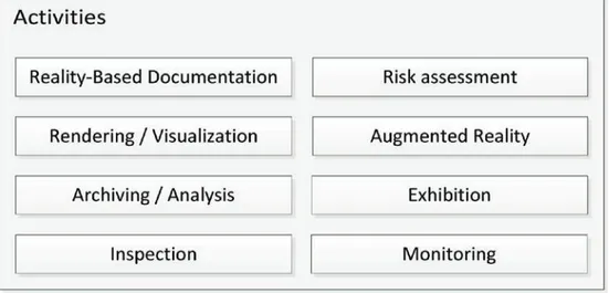
A summary of straightforward activities that might come from the photogrammetric workflow is pre-sented in Fig. 2.
From inexpensive surveys in the field, even with minimum resources, many activities might be un-dertaken by photogrammetric computer vision users taking pictures with whatever digital ca-mera.
A simple example would be for instance the mo-nitoring over time of archaeological sites, archi-tectural monuments, buildings, objects and artefacts. The minimum resources are the pictures acquired on site by any experience user.
The idea is not photogrammetry per se but to im-prove management of cultural heritage objects, monuments and sites where resources for heri-tage all over the world are always not enough.
2. Summary of activities that might be undertaken after a photogrammetric workflow.
Cova Remígia, Ares del Maestre, Castellón (Spain). The sizes of the four case studies range between 24-200 m2. Photographs were acquired with a compact Panasonic Lumix DMC-LX3 digital camera for case study a, and with a Canon 1Ds Mark III (different wide angle lenses were used) on case studies b-d from different positions: 9, 24, 38 and 122 respectively. The resolution of the former ca-mera was 3776 x 2520 pixels while for the latter 5616 x 3744 pixels.
All the image-based photogrammetric processing was carried out with FOTOGIFLE software develo-ped in-house by the authors in our department. The camera was always calibrated on purpose. It means that pictures were not only taken to yield photorealistic 3D models but camera calibration, orientation in space, dense image matching (Fig. 4a) and orthoimagery (Fig. 4b), among other deli-verables. Besides, 3D models might be worth prin-ting out in 3D in a variety of materials with 3D RECORDING APPLICATIONS IN ARChITECTuRE
AND ARChAEOLOGy
In this section four documentation case studies are presented: two architectural and two archa-eological projects.
The documentation case studies were undertaken by the authors in the last years. The variety of sha-pes can be considered enough to confirm the pho-togrammetric performance of the surveys. More room would be required to present small objects and artefacts obtained either from archa-eological excavations or architectural features. Ne-vertheless, the results can be extrapolated to further monuments and sites.
Fig. 3 displays the four selected case studies: a) wall of masonry sandstone in Taybeh Village -Petra (Jordan); b) main façade of the Palace of Marquis of Dos Aguas (currently National Cera-mics Museum) in Valencia (Spain); c) Djin Block No. 9 in Petra Archaeological Park (Jordan); and d)
printers at different scales.
heritage objects, monuments and places require most of the times colour photorealistic 3D models instead of point clouds. Depending on the pur-pose, it might be necessary to deliver just stan-dard 3D models instead of photorealistic models. Fig. 5 illustrated the difference between visuali-sing 3D point clouds, 3D models and photoreali-stic 3D models. worth mentioning is that the better the quality of the input pictures used for draping (texturing) the better will be the feeling of realism of the output photorealistic 3D model. INTERACTION AND DISSEMINATION wITh 3DVEM – 3D VIEwER, EDITOR AND METER SOFTwARE The chances to improve understanding and foster dissemination are paramount whenever virtual in-teraction starts either at home, in the office, in an exhibition centre, in a museum, etc. 3DVEM – 3D Viewer, Editor and Meter is a new free software released to the market to easy communication between information users and information pro-viders. It is possible to interact either with geore-ferenced point clouds (Fig. 5a), standard 3D models (Fig. 5b) and photorealistic 3D models (Fig. 5c) individually or layer-by-layer, turning the different datasets on and off using a simple menu. In addition, different rendering modes are imple-mented to enhance understanding of the data. There is a chance to add: personal points of view at a wide range of attitudes, annotations and re-ferences on the models, as well as take unlimited number of measurements (Fig. 6).
Furthermore, the visual presentation of the re-sults can be displayed in both perspective and or-thogonal projection. The perspective visualisation resembles the way users visualise and feel the ob-ject, monument or site. however, the orthogonal projection is preferred to print out plans and ele-vations at a specific object scale.
3DVEM – Live software enhances the capabilities of 3DVEM – Viewer, Editor and Meter and allows users to create animations on-the-fly as well as on standard/customized movie formats (Fig. 7). Two additional features should be highlighted
from 3DVEM – Live: first) the chance to add your personal pictures to the photorealistic 3D model; second) the chance to change on-the-fly the ca-mera setting, ranging from super wide angle len-ses up to tele lenlen-ses.
DISCuSSION AND CONCLuSIONS
There is an increasing demand of derived 3D mo-dels to be integrated in current heritage docu-mentation workflows. The chances to monitor in a virtual environment the evolution of architectu-ral surveys, archaeological excavation/sites, and found objects/artefacts are limitless.
From our own experience, the creation of accu-rate high quality replicas is not straightforward. Delivery of accurate photorealistic 3D models re-quires experienced users in the fields of geoma-tics, cultural heritage and geosciences, just to name a few. however, almost everybody enjoys interacting with virtual worlds. Therefore, more well-driven automatic solutions are required to fulfil information user requirements, in a way that conservation managers, art historians, architects and archaeologists make extensive use by their own of deliverables such as photorealistic 3D mo-dels achieved through cultural heritage recording. But one thing is delivering simplistic virtual words (that definitely have their room to carry out better hypothesis of the past, complex analysis, dissemi-nation through mixed and augmented reality, and last but not least videogames), and even unstruc-tured 3D point clouds, and another high quality, high resolution, high accuracy photorealistic 3D models that might be considered real replicas of both the past and the present.
Many different computer vision, photogrammetry, and laser scanning solutions can be found in the market today. without any doubt, there exist po-werful image-based computer vision packages that allow users to speed up the documentation process and reduce costs, for instance, during ex-cavations (Dellepiane et al. 2013; Forte et al, 2012) or even for objects in architecture, cultural heritage and archaeology (kersten and Lindstaedt, 2012). One of the main concerns is the reliability of the derived outputs, considering careful data
4. Image-based processing for case study c: a) orientation and dense image matching in object space; b) orthoimagery.
5. Visualisation of case study a as: a) single colour point cloud; b) 3D model; and c) photorealistic 3D model.
acquisition and autonomous processing. Therefore, photogrammetry still will have its place to guarantee the precision of the whole proces-sing pipeline either standalone with semi-automa-tic approaches, combined with powerful computer vision solutions or integrated with ter-restrial laser scanning.
This paper presented a state-of-the-art photo-grammetric workflow that allows the creation of high quality photorealistic 3D models in two ar-chitectural features and two archaeological sites. The diversity and complexity of the close range objects allow us to confirm the feasibility of the processing to achieve high quality virtual outputs either in 2D (orthophoto mosaics) or in 3D (pho-torealistic models). Furthermore, high quality in-teractions and animations can be quickly rendered through the 3DVEM software.
New tools and approaches are increasingly pre-sented to the market, as well as extensive datasets acquired by digital cameras and laser scanners. Altogether with improved computer technology will figure more efficient photogrammetric com-puter vision algorithms that will improve the per-formance of the derived products.
6. 3DVEM – 3D Viewer, Editor and Meter with inserted coded labels (points), measured features and viewpoints.
REFERENCES
Barazzetti, L., Scaioni, M., Re-mondino, F. (2 010), Orientation and 3D modelling from marker-less terrestrial images: combining accuracy with automation, in THE PHOTOGRAMMETRIC RECORD, 25(132), pp. 356–381. Böhler, W. (2006), Comparison of 3D laser scanning and oth er 3D measurement techniques, Recor-ding, Mod eling and Visu alization of Cultural Heritage (Baltsavias, E., Gruen, A., Van Gool, L., Pa te-raki, M. Eds.), Tay lor & Franc is Group, London, pp. 89-99. Courc hay, J., Pons, J.-P., Mo-nasse, P., Keriven, R., 2010 , Den se and accu rate spatio-tem-poral multi-view stereovision, in Computer Vision – ACCV 2009 , LECTURE NOTES IN COMPUTER SCIENCE, 5995, pp. 11-22. Dellepiane, Matteo, Dell’Unto, Ni-colò, Callieri, Marco, Lindgren , Stefan, Scopigno, Roberto (2013), Archaeological excavation monito-ring using dense stereo matching techniques, in JOURNAL OF CUL-TURAL HERITAGE, 14(3), pp. 201-210.
Forte, M., Dell’Unto, N., Issavi, J., Onsurez, L., Lercari, N., 2012. 3D archaeology at Çatalhöyük, in IN-TERNATIONAL JOURNAL OF HERI-TAGE IN THE DIGITAL ERA, 1(3), pp. 351-378.
Furukawa, Y., Ponce, J., 2010, Ac-curate, dense, and robust multi-view stereopsis, in IEEE TRANSACTIONS ON PATTE RN ANALYSIS AND MACHINE INTELLI GENCE, 32(8), pp. 1362-1376. GIFLE (2012), 12 Tips for metric photography of architectural and archaeological cultural heritage to extract 2D/3D/4D measurements, Grupo de Investigación en Foto-grametría y Láser Escán er. h ttp ://g ifle.web s.up v.es/Mi scel-lany.php (Access on July 3 , 2013).
Grussenmeyer, P., Hanke, K., Streilein, A. (2002), Architectural Photog rammetry, Digital Photo-grammetry (Kasser, M., Egels, Y., eds.). Taylor & Francis, London, pp. 300-339.
Jones, David M. (2011), 3D Laser Scan nin g for Heritage. 2 nd Edi-tion. Advice and guidance to users on laser scanning in archaeology and architecture (Ed). English He-ritage Publishing.
Kersten , T.P., Lin dstaedt, M., 2012, Poten tial of au tomatic 3D object reconstruction from multi-ple images for applications in ar-chitecture, cultural heritage and archaeology, in INTERNATIONAL JOURNAL OF HERITAGE IN THE DI-GITAL ERA, 1(3), pp. 399-420. Läbe, T., Förstner, W. (2006), Au-tomatic relative orientation of images. Proc eedings of the 5th Turkish-German Joint Geod etic Days, Berlin. 6 pages. http://www.ipb.un i-bonn.de/file-admin/publication/papers/2006/la ebe06.automatic.pdf
Lerma, J.L., Navarro, S., Cabrel-les, M., Seguí, A.E., Haddad, N. Y Akasheh, T. (2011), Integration of Laser Sc anning and Imagery for Photorealistic 3D Architectu ral Documentation, Laser Scanning, Theory and Applications (Wang, C.-C., Ed.). InTech, Rijeka, pp. 4 1 3 - 4 3 0 . http://cdn.intechopen.com/pdfs/1 5 8 1 8 / I n T e c h -Integration_of_laser_scanning_a nd_imagery_for_photorealistic_3 d_architectural_documentation.p df.
Lerma, J.L., Navarro, S., Cabrel-les, M., Seguí, A.E., Hernández, D. (2012), Automatic orientation and 3D modellin g from markerless rock art imagery, in ISPRS JOUR-NAL OF PHOTOGRAMMETRY AND REMOTE SENSING, 76, pp. 64-75. Lerma, J.L., Navarro, S., Cabrel-les, M., Villaverde, V. (2010), Ter-restrial laser scanning and close range photogrammetry for 3D
ar-c haeologiar-cal doar-cumentation: the Upper Palaeolithic Cave of Par-palló as a case study, in JOURNAL OF ARCHAEOLOGICAL SCIENCE, 37, 3, pp. 499-507.
Lerma, José Luis (2010), Heritage recording using image-based te-c hniques, Heritag e in the Digital Era (Ioannides, M., Alonzo, A., Ge-orgopoulos, A., Kalisperis, L., Brown , A., Pitzalis, D., Eds.), Multi-Science Publishing, pp. 83-93.
Letellier, Robin, S chmid, Werner, LeBlanc, François (2007), Recor-d in g, Recor-documentation, anRecor-d infor-mation management for the c onservation of heritage places: guiding principles, The Getty Con-servation Institute, Los Angeles. Moreels, P., Perona, P., (2007), E valuation of Features Detectors and Descriptors based on 3D Ob-jects, in INTERNATIONAL JOUR-NAL OF COMPUTER VISION, 73(3), pp. 263–284.
P ierrot Deseillign y, M., Clery, I. (20 11), APE RO, an Open Source Bundle Adjustment Software for Automatic Calibration and Orien-tation of a S et of Images, in IN-T ERNAIN-TIONAL ARCHIVES OF P HOTOGRAMMETRY, REMOTE SENSING AND SPATIAL INFORMA-T ION SCIENCES, 38(5/W16), Trento, Italy (on CD-ROM). Pollefeys, M., Koch, R., Van Gool, L. (19 99), Self-calibration and metric reconstruction in spite of varying and unknown internal ca-mera parameters, in INTERNATIO-NAL JOURINTERNATIO-NAL OF COMPUT ER VISION, 32(1), pp. 7-25. Remondino, F, Del Pizzo, S., Ker-sten, Th ., Troisi, S., 201 2. Low-c ost and open-sourLow-ce solutions for automated image orientation – a critical overview, in LE CTURE NOT ES IN COMPUTER SCIENCE 7616, Springer-Verlag, Berlin Hei-delberg, pp. 40-54.
Remondino, Fabio, E l-Hakim, S.
(2006), Image-based 3D model-ling: a review, in THE PHOTO-GRAMMETRIC RECORD, Blackwell Publishing Ltd., 21(115), pp. 269-291.
Remondino, Fabio, Ressl, Camillo (2006), Overview and experiences in automated markerless image orientation, in INTERNATIONAL ARCHIVES OF PHOTOGRAMME-TRY, REMOTE SENSING AND SPA-TIAL INFORMATION SCIENCES, 37(B5-1), pp. 199-206. Slama, C.C., Henriksen, S.W., Theurer, C. (1980 ), Manual of Photogrammetry. 4th. E dition, Americ an Soc iety of Ph otogram-metry, Falls Chu rch Virginia, EEUU, 1056 pp.
Waldhäusl, Peter, Ogleby, Cliff (1994), 3x3-Rules for simple pho-togrammetric documentation of architecture, INTERNATIONAL AR-CHIVES OF PHOTOGRAMMET RY AND REMOTE S ENS ING, vol. 30, part 5, pp. 426-429.
ACKNOWLEDGEMENTS The authors would like to thank the support provided by the Spa-nish Ministry of Science and Inno-vation to the project HAR2010-18620.