Università Politecnica delle Marche
Dipartimento Scienze Vita e Ambiente
“The Use of REMOTE SENSING TECHNIQUES to support
MARINE PROTECTED AREAS management and Marine
Spatial Planning decisions”
PhD THESIS
Paula Andrea Zapata Ramírez
Università Politecnica delle Marche
Dipartimento Scienze Vita e Ambiente
“The Use of REMOTE SENSING TECHNIQUES to support
MARINE PROTECTED AREAS management and Marine
Spatial Planning decisions”
PhD Thesis
Paula Andrea Zapata Ramírez
PhD Program in Marine Biology and Ecology
February 2016
Thesis Director External Supervisor
Dr. Carlo Cerrano Dr. David Scaradozzi
Professor Assistant Professor
Paula Andrea Zapata Ramírez
Contents
Acknowledgment………. 6
Abstract……… 9
Sommario……….. 11
Introduction………. 13
Chapter 1 Innovative study methods for the Mediterranean coralligenous habitats………. 28
1. Introduction……….. 27
2. Classic survey methods………. 31
3. Underwater mapping: state of the art……… 32
3.1 Acoustic sensors………. 32
3.2 In situ optical methods……….. 34
4. Photo and video mosaicking technologies……….. 35
4.1 2D mosaicing reconstructions……….. 36
4.2 3D mosaicing reconstructions……….. 37
5. Robotic technological advances……….. 41
1.1 Data gathering in delicate biological marine environments with robots……….. 42
6. Integrating acoustic and optical information datasets……… 42
7. Future directions……… 46
8. References………. 48
Chapter 2 Innovative strategy and process for underwater data gathering and results elaboration 59 1. Introduction……….. 60
2. Features and innovations………. 62
3. Global architecture……….. 63
A. Mobile acquisition device (Android Board)……… 64
B. PHP/HTML5 Web server………. 65
C. 3D Engine module and database……….. 65
D. Cloud manager……….. 65 E. Home navigator……… 66 4. Implementation……….. 66 A. Android application……… 66 B. Web application……… 68 C. Web server……… 69 D. 3D Engine server……….. 70 5. Results……… 71 6. Conclusion……….. 76 7. References………. 76
Chapter 3 A multi approach to map and model the distribution of coralligenous and cave
environments. A case study at Portofino Marine Protected Area (Ligurian Sea, Italy) 79
1. Introduction……….. 80
2. Study area……….. 82
2.1 Regional setting………. 82
2.1.1 The Portofino MPA………. 83
3. Method………. 84
3.1 Classification approach………. 84
3.2 Remote sensing and in situ measurements……… 85
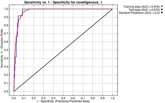
3.3 Supervised classification and accuracy assessment (Kappa)……….. 89
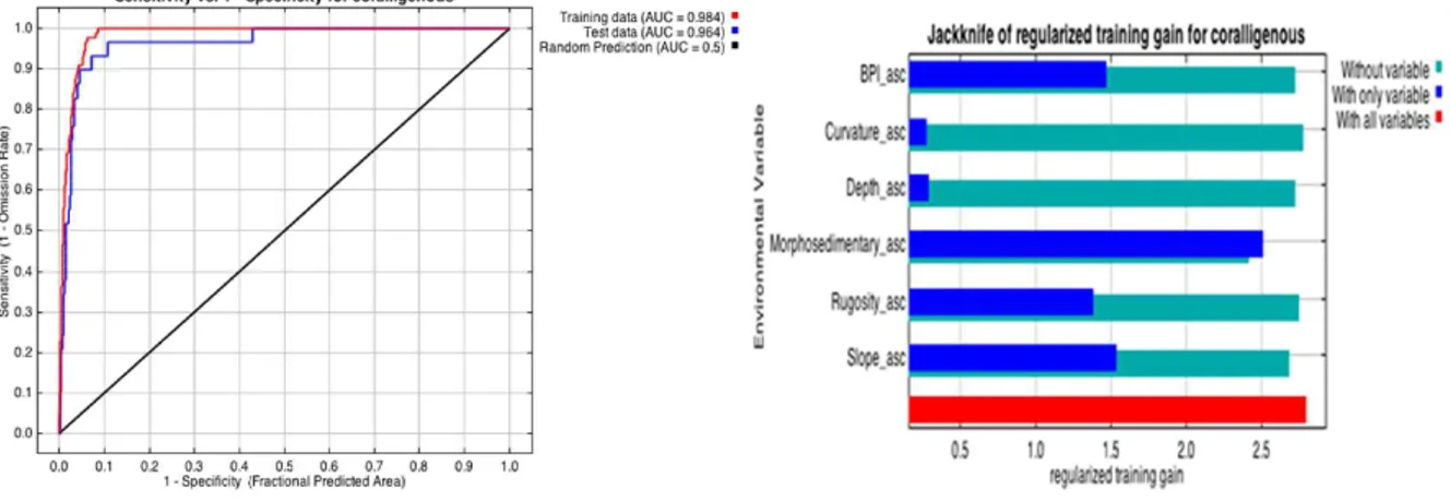
3.4 Habitat suitability model and accuracy assessment (AUC)………. 89
4. Management applications……….. 91
5. Results……… 91
5.1 Description of the area………. 91
5.2 Results from different classifiers……… 93
5.3 Zonal statistical analysis……… 96
6. Discussion……… 96
6.1 Implications for management……….. 104
6.2 H.S Potential improvements………. 105
7. Conclusions……… 105
8. References………. 106
Chapter 4 Using MaxEnt to understand and predict the distribution of coralligenous environments 122 1. Introduction……….. 123
2. Materials and methods………. 124
2.1 Data sources………. 124
2.2 Habitat suitability models using Maximum entropy model (MaxEnt)………. 126
3. Results……… 126
4. Conclusions……… 132
5. References……….. 129
Chapter 5 Modelling the distribution of rocky shore indicator species and its relation to the geomorphology and anthropogenic pressures at Portofino MPA 131 1. Introduction……….. 132
2. Materials and methods………. 134
2.1 Study area……….. 134
2.2 Environmental variables (EVs)………. 136
2.2.1 Geomorphological expression………. 136
2.2.2 Anthropogenic pressures……….138
2.3 Data inventory………. 139
2.4 Modelling technique and validation……… 140
3.1 CARLIT method observations……… 142
3.2 Modelling distribution patterns and importance of variables of contribution….. 142
4. Discussion……… 148
5. Conclusions……… 152
6. References………. 153
Chapter 6 Guidelines for monitoring measures of coralligenous assemblages within a Management context 163 1. Remark………..163
2. Why is it important to monitor coralligenous environments ?... 164
3. How remote sensing, habitat mapping and distribution modelling tools are useful for coralligenous management ?... 165
4. How to do it……….. 166
5 Costs……… 166
6 What are the benefits of the implementation of this methodological framework on management implications?... 166
7 Skills and Training………. 168
8 Portofino MPA case study……… 169
8.1 Portofino MPA habitat map………. 170
8.2 Ground truthing verification……… 171
8.3 Final Habitat Product released with known accuracy results……….. 172
8.4 Distribution Models……… 174
8.4.1 Presence only algorithm approach……….. 174
8.4.2 Presence – absence algorithm……… 175
8.4.3 Results………..176
9 References………. 178
6
Aknolowdgment
I am deeply indebted to many people for their help throughout all aspects of this thesis. I have to thank my advisor Carlo Cerrano, for his guidance and suggestions over the past couple of years, for his insights and patience, for sharing my sense of humor, and for encouraging me to do this degree my way. We went to some amazing places together, had some great dives and generally had an incredible time. Thanks for the constructive comments and feed‐back received on my research and for having the door all the time open to discuss. For provided me with so many opportunities to learn and get involved in amazing trainings in exciting parts of the world. I am further indebted with him for the opportunity to be part of the Initial Training program ‘Training Network for Monitoring Mediterranean Marine Protected Areas’ (MMMPA: FP7‐PEOPLE‐2011‐ITN). MMMPA allowed me to have the chance to met amazing colleagues, my sincere gratitude to all the members, especially the ESRs for their extraordinary support, helpful feedback, ceaseless encouragement and the fantastic network, the best team ever !!!.
I would, also, like to thank my cotuthor, David Scaradozzi for his excellent instruction and guidance regarding robotic stuff, for his time, critical comments, insights and support during the entire study is immensely appreciated. A big thank you goes to Miquele Marconi for the time invested in discussions of the spatial aspects of my project and for the nice dinners on the terrace. Thanks to those who worked with me during fieldwork ; Carla Huete‐Stauffer, Ubaldo Pantaleo, Marco Palma, Antonio Calo, Jose Antonio Charton, Massimo Ponti and all my colleagues of the MMMPA project for the great time in different terrific places.
I need to also thank my lab mates for helping me through all stages of this degree; Azu, Dani and Fabri as well as Claudia Ciotti, Mara Giardini and Silvia Tazioli for their help with the administrative management. I received invaluable data from many sources, without whom none of this would have been possible. Thanks to the Ligurian Region and Portofino MPA staff for sharing valuable data.
7
Finally but not least a huge thanks to all my family who never doubted of me for a moment and encouraged me to succeed at whatever I desired. I would especially like to thank my partner Cristian, he provided the most compelling motivation of all to complete this thesis. Thanks as well for always being able to make me laugh and reminding me of all of the important things in life other than academia.
9
Abstract
The present doctoral degree thesis is based on the implementation of remote sensing (RS) methods habitat mapping and distribution modelling (DMs) techniques as management tools to assess the status of benthic habitats and to support Marine Spatial Planning (MSP) decisions.
A Geographic Information System (GIS) was used to model the spatial boundaries of the physical and biological datasets, as well to assess the proximity of anthropogenic pressures. Through spatial examination, image analysis and underwater video, the biological patterns of habitats/species were related to the variation in geomorphology based on geophysical substrate properties gathered through RS techniques in combination with optical data, collected during the ground truthing sampling. In addition, DMs and classification approaches were applied and their accuracy tested. Finally, a methodological framework was suggested as guideline to inform and provide recommendations to managers and policymakers about how to accurately locate and best protect benthic habitats and its resources, how to evidence possible different sensitivities between habitats in relation to geomorphology, create or redefine different zones or levels of protections at Marine Protected Areas and how to forecast future changes due to global warming and/or anthropogenic activities.
General results demonstrate that the produced maps provide information about where the habitats/species could be present and how they are related to the geomorphological context and/or the anthropogenic pressures. Results emphasize the role of critical expert evaluation of spatial predictions before they are used to guide policy. We conclude that RS and DMs could be very useful tools for understanding the distribution of species–habitat associations and to help resources managers make informed and ecologically relevant decisions.
11
Sommario
La presente tesi di dottorato prende in considerazione tecniche di rilevamento acustiche (Remote sensing, RS) e ottiche per lo sviluppo di modelli di distribuzione e mappatura (Distribution and mapping modelling, DMS) come strumenti di gestione per valutare lo stato degli habitat bentonici e per supportare decisioni relative alla pianificazione dello spazio marittimo (Marine Spatial Planning). Modelli di distribuzione di habitat e specie sono stati analizzati congiuntamente ad analisi spaziali e analisi di immagine da video subacquei, e messi in relazione alle caratteristiche geomorfologiche del substrato, raccolte tramite RS e validate tramite immersioni di controllo. L’impiego del Sistema Informativo Geografico (GIS) ha permesso di disegnare spazialmente la distribuzione e l’estensione degli habitat così come la distribuzione e l’intensità delle pressioni antropiche, creando quindi un dataset utile a sostenere adeguate scelte gestionali. L’accuratezza dei modelli è stata testata e confrontata. I risultati hanno permesso di definire un quadro metodologico che potrebbe essere facilmente recepito a fini gestionali. Sono infatti state sviluppate delle linee guida da distribuire ai gestori di Aree Marine Protette e ai manger interessati alla gestione della fascia costiera, utili ad inviduare le aree prioritarie in termini di conservazione, sulla base di modelli predittivi che potrebbero suggerire anche eventuali azioni di recupero ambientale. I risultati ottenuti dal presente lavoro mettono quindi in relazione complessità geomorfologica e habitats, permettendo di sviluppare piani di gestione che prendono in considerazione la distribuzione e l’intensità degli impatti antropici.
13
Introduction
Governmental bodies are increasingly obliged to manage the marine environment under a suite of legislative packages to ensure appropriate and sustainable management of marine ecosystems. In specific, the European Union Marine Strategy Framework Directive (MSFD) requires the Good Environmental Status of marine environments (GES) in Europe's regional seas (Borja et al., 2013; 2014). Faced with the challenge of implementing MSDF conservation goals, policymakers are tackled with the problem of 'the need to know versus the need to act'. In recent years, marine spatial planning (MPS) has gained considerable importance toward to a more knowledgeable of an integrated ecosystem based management of marine areas (Douvere, 2011) with which to address and achieve conservation goals. The concept has emerged as a highly promoted approach to implementing integrated management of coastal and ocean areas. MSP is directly linked to ecosystem based management (EBM), the ecosystem approach to fisheries (EAF), geographic information systems (GIS), marine protected areas (MPAs) among others. As a result, MSP is a promising way to achieve simultaneously social, economic, and ecological objectives by means of a more rational and scientifically‐based organization of the use of ocean space (Gilbert et al., 2015).
Effective implementation of ecosystem management and marine spatial planning (MSP) relies on a comprehensive geospatial framework with which to understand the process that determine the observed distribution patterns of species in marine ecosystems as a starting point. In particular, biological, geological and physical information and the mapping of the ecosystem is the first step of MSP and the base for the whole planning and proxies, such as suitable environmental conditions, for any given feature may be needed. This information should contains spatially continuous and broad scale data on the distribution and their interaction, with which to make informed and ecologically relevant decisions. In addition, information about the influence of the location of the human activities on the marine ecosystem combined with detailed spatial data, is required to ensure adequate protection and management of the ecosystems itself. In particular, the MSFD states that
14
“the structure and function of seafloor ecosystems must be safeguarded against harm from human activities”. To achieve this, the MSFD also requires each EU Member State to monitor pressures on the ecosystems and take actions which lead to a ‘good environmental status’ by 2020. Therefore, MSFD offers a crucial opportunity to Member States to build and standardise novel innovative methodological assessments and to incorporate today's state‐of‐the‐art technological developments into current monitoring practices and with which to develop programs of measures designed to achieve or maintain a Good Environmental Status (GES) by 2020.
Remote sensing, habitat mapping and distribution models as tools to support MSP and MPAs management decisions
The use of Remote Sensing (RS) techniques for the production of benthic habitats maps is an essential tool for seabed management and assessing human impacts on marine benthic ecosystems (Harris and Baker, 2012). Maps derivate from remote sensing (RS) techniques have proved to be a cost‐effective and productive endeavour to achieve MSFD goals (e.g Connor, 2005; Galparsoro et al., 2013; García‐Alegre et al., 2014; Buhl‐Mortensen et al.,2015). The resulting maps have the potential to provide a broad‐scale synoptic view of benthic environments and species providing temporal data that may be used to assess events in community dynamics (Zapata‐Ramirez et al., 2013a) and in long term monitoring practices. As a result, these techniques have proved to be a cost‐effective and productive endeavour to achieve management objectives, but until recently, the lack of high‐ resolution environmental datasets has been a major restriction in the marine realm, in particular below the mesophotic depths. In addition, direct inventories and surveys on these areas are expensive and time‐consuming and are therefore impractical to conduct over extensive seascapes (Zapata‐Ramirez et al., 2013a and reference therein). However, recent developments in the last couple of decades on new state‐of‐the‐art technology is now available for the visualisation and investigation of sea bed structures and biological communities‐species, and for precision sampling in rugged terrain. While deeper areas are still considered a difficult environment to work in, the
15
advantage of sophisticated acoustic mapping (e.g. multibeam sonars) and submersibles with high‐ resolution video and sampling capabilities has revolutionised our ability to accurately geo‐ referenced and describe different benthic habitats in challenging zones. Additionally, the implementation of distribution models (DM) procedures have resulted in an increased availability of environmental data (Dutertre et al., 2013; Giusti et al., 2014; Gormley et al., 2013; Greathead et al., 2014) with which to explore the relationships between abiotic and biotic patterns. Furthermore, DMs relate the presence of habitats/species in a location to a set of environmental variables, which then allows predicted distributions to be mapped across an entire region (Reiss et al., 2015). In this context, DMs based on habitat‐species/environment relationships provides a potentially useful way to synthesise information from scattered samples into coherent maps of distributions of species and habitats, ecological goods, and services (Reiss et al., 2015). More specifically these tools can be applied (i) to explore the possible effects of climate change on benthic species distribution patterns (Elith et al., 2011), (ii) to assess habitat distributions in areas that, due to their complexity, are difficult to study and therefore have limited data availability (Fourcade et al., 2014), (iii) to estimate the most suitable areas for a species and infer probability of presence in regions where no systematic surveys are available (Martin et al., 2014), (iv) to illustrate how human impacts interact with their distribution (Bandelj et al., 2009; Martinez et al., 2012) and (v) to identify optimal sites for restoration initiatives (Elsäßer et al., 2013; Valle et al., 2015).
The integration of habitat mapping techniques and DM approaches will allow the development and application of appropriate management strategies providing benefits in terms of scale, consistency, and volume of data collected; potentially providing a means to address some of the key questions inhibiting wider use of these models in MSP and the assessment of species vulnerability to climate change (Piroddi et al., 2015; Reiss et al., 2015). As a result, if the distribution of marine habitats is known, then the spatial distribution of the potential environmental or anthropogenic risks of impact can be estimated, thereby helping to identify the most efficient management (Stelzenmüller et al., 2010) and monitoring solutions.
16
OBJECTIVE AND STRUCTURE OF THE THESIS
In specific, the present study is concerned with the application of RS techniques and biological data to map and model marine benthic habitats in MPAs that could support MSP activities. In particular, the study focus on two important temperate reefs at Portofino’s MPA: i) Coralligenous habitats and ii) Rocky shore indicator species located at Portofino MPA as case study.
i) Coralligenous habitats
Coralligenous habitats provide several essential ecological, economic and cultural services. While scientific knowledge about their structure, functioning and responses to stressors has increased exponentially over the past decade, the state of this habitats has declined during this period, at a comparable rate in many places (Zapata‐Ramirez et al., 2013b). Their importance have been recognised under different international, European and national conservation frameworks (e.g. Habitats Directive; European Water Framework Directive) and as protected habitats in the EC Regulation No. 1967/2006 concerning management measures for the sustainable exploitation of fishery resources (European Commission, 2006).
Their habitats are of special interest in the Mediterranean sea because they represent one of the "hot‐spots" of biodiversity importance, around 20% of Mediterranean species, and have great structural and functional complexity (Ballesteros 2006). Furthermore, these environments are considered of great significance for fisheries and CO2 regulation (Zapata‐Ramirez et al., submitted and references therein). The species that dominate coralligenous seascapes are encrusting calcareous algae, sponges, cnidarians, bryozoans and tunicates (Ballesteros 2006; Kipson et al., 2011). Some of these species have a slow structural dynamics and high longevity (Ballesteros 2006; Teixidó et al. 2011). Therefore the low vitality of this community involves a vulnerability to various disturbances such as destructive fishing practices, pollution, invasive species or mass mortality outbreaks (Cerrano et al. 2000, Coma et al., 2004, UNEP‐MAP‐RAC/SPA, 2008, Garrabou et al., 2009).
17
Fishing activities, have been shown to damage or destroy long‐lived emergent epifaunal animals such as corals and sponges, harming the three‐dimensional complexity of the seabed, and subsequently reducing species diversity and faunal biomass (Zapata‐Ramirez et al., 2013a). Thus, these habitats are in urgent need of efficient monitoring and management programs to sustain their biological, economic and cultural values for the global community. The first step in managing any threat is to understand it, a barrier to develop management plans in coralligenous environments is that they distribution remain poorly characterized because of the difficulties associated with its exploration and therefore they have not been mapped with sufficient accuracy and at spatial resolutions high enough to support their efficient management and conservation (Agnesi et al., 2008; Pergent, 2011). Furthermore, there is a missing consensual methodology for its monitoring and no environmental or ecological quality indexes have been established (UNEP‐MAP‐RAC/SPA, 2011; EUROPEAN COMMISSION: SEC, 2011). Knowledge on the distribution, biodiversity and its relation with functioning is therefore crucial for providing information relevant to the identification and implementation of technical options for their conservation and sustainable use (EUROPEAN COMMISSION: SEC, 2011). In order to improve our knowledge about this environments and to set up effective management and protection schemes, high quality benthic/habitat maps are essential, both at a large scale, indicating assemblages occurrence within the Mediterranean basin (e.g. Martin et al., 2014), and at a more local scale (e.g. Agnesi et al., 2008) detailing the spatial distribution of coralligenous vitality and status (pristine vs. damaged). Further development of predictive habitat mapping techniques is also necessary to guide the exploration for the known and the unknown coralligenous areas around the Mediterranean basin. In addition, as management schemes become established, it will become important to follow‐up the coralligenous status and recovery with repeated surveys (e.g monitoring) and habitat mapping efforts (EUROPEAN COMMISSION: SEC, 2011).
18
ii) Rocky shore indicator species
Similar tendencies are currently occurring at rocky shore species. In particular, loss of forests of
Cystoseira amentacea (a protected species) has been observed in many coastal areas. Coastal
urbanization, marine pollution and outbreak of herbivores (i.e. sea urchins and herbivorous fish) are some of the most important factors affecting marine forests (for a review see Mineur et al., 2015).
Cystoseira species are listed in two European Conventions (Barcelona Convention, 1976 and Bern
Convention, 1979), but very few tangible focussed actions have been carried out so far for their conservation, monitoring and management, especially as concern the assessment of indicator species distribution or the establishment of marine protected areas (MPAs). An exception is the cartography of Cystoseira belts in the infra‐littoral fringe performed to assess the ecological status of coastal waters using the CARLIT index, under the Water Framework Directive (WFD) 2000/60/EU (Ballesteros et al., 2007, Mangialajo et al., 2007). However, this index is often performed only on limited stretches of the rocky coastlines hampering the assessment and monitoring at more large scales. Therefore, it is extremely important to increase our knowledge on rocky shore indicator species, updating maps on their distribution at more large scales, following their evolution over time and, if necessary, considering restoration (Gianni et al., 2013) in the case of important engineering species like Cystoseira amentacea.
In agreement with MSFD (2008/56/EC) and in line with Directive 2007/2/EC of the European Parliament, it is necessary and appropriate to provide the development of criteria and specifications for methodological standards to guarantee consistency and to allow for comparison between marine regions or sub‐regions of the extent to which good environmental status (GES) is being achieved (Piha and Zampoukas, 2011). Consequently, the main objectives of this thesis are:
i) Test the potential of the remote sensing, habitat mapping and distribution modelling techniques
to detect the importance of different environmental variables (EVs), that define the distribution of temperate reefs (coralligenous assemblages and rocky shore species)at Portofino’s MPA, that can
19
contribute to the baseline information regarding presence and distribution of the Specially Protected Areas of Mediterranean Importance (SPAMI), and regarding processes/functions that characterized the habitats.
ii) Develop, test and validate a rapid and cost‐effective standardized monitoring tools to improve our
understanding of ecosystem and biodiversity changes, for integration into a unique and holistic assessment that can be applicable to a wide array of Mediterranean MPAs.
iii) Assess the resulting maps as potential tools in management strategies that could contribute to
the MSDF requirements.
iv) Provide an easy and understandable guideline to inform and provide recommendations to
managers and policymakers about how to best protect coralligenous resources, how to create or redefine different zones or levels of protections at Marine Protected Areas (MPA’s) and how to forecast future changes due to global warming and/or anthropogenic activities.
The thesis is divided in six chapters:
Chapter 1- Innovative study methods for the Mediterranean coralligenous habitats.
This chapter described the state of the art of the different methodologies currently applied on benthic habitats, in particular focused on diverse assessments currently used in “reef” environments The study identified still photographs and video mosaics as the most suitable in situ data collection method for benthic habitats. Optical‐based methods (i.e. video and stills cameras) are becoming more commonly used in research because they collect data quickly reducing the time spent underwater, provide high‐resolution images of the organisms and cover large areas quickly (Van Rein et al., 2011; McKinnon et al., 2011). In addition, they generate permanent survey records, achieve greater sampling objectivity than traditional diver observations and have a low environmental impact in sensitive areas of conservation importance (Lirman et al., 2007; He et al., 2012).
20
Chapter 2 – Innovative strategy and process for underwater data gathering and results elaboration.
This chapter is focused in the application of in situ optical techniques and their process. In order to investigate the monitoring potential of the still photographs and video mosaics method to collect in situ data, we randomly sampled different zones at Portofino MPA. All field activities were conducted using conventional SCUBA. Two calibrated Go‐pro Hero2 video camera and one Go‐Pro Hero 2 to collect pictures were used to gather the in situ optical information. In collaboration of the engineering team of the Dipartimento di Ingegneria dell’Informazione, of Università Politecnica delle Marche the chapter describes the design and realization of a device, called DiRAMa, and the relative architecture for data gathering in underwater environments. The device is planned to make the image and data acquisition easy, and let the user upload all the information on an appropriate Web Server as soon as an Internet connection is available. As a result of DiRAMa implementation we obtained mosaics with a ground resolution of 1–2 mm per pixel with which identify coral colonies and/or other benthic components (e.g corals, sponges) useful to detect changes in species composition at very high resolution.
Chapter 3- A multi approach to map and model the distribution of coralligenous and cave environments. A case study at Portofino Marine Protected Area (Ligurian Sea, Italy).
This chapter focused in the methodological assessment applied to map and model the distribution of coralligenous and cave habitats. Data collected with a Multibeam Echosounder System (MBES) in combination with optical data, collected during the ground truthing sampling, and following the methodology proposed by the in situ optical techniques previously described in chapter 2 were used. The chapter tackled the difficulties to accurately map and explore Coralligenous, Caves and Overhangs on the case study. We show how MBES were used in combination with optical data, to map these bioconcretions with acceptable accuracy and discriminate the main habitat types. Nevertheless, in areas where large changes in the geomorphology over short distances happened,
21
especially near the notches, caves and overhangs some misclassification as well as an increase in the prediction error of the classification occurred, probably due to the standard deployment of the MBES’s orientation. However, and despite these limitations, the results demonstrate that the produced habitat map and the DM technique provide critical information about where the habitats could be present and how they are related to the geomorphological context.
Chapter 4- Using Maxent to understand and predict the distribution of coralligenous environments
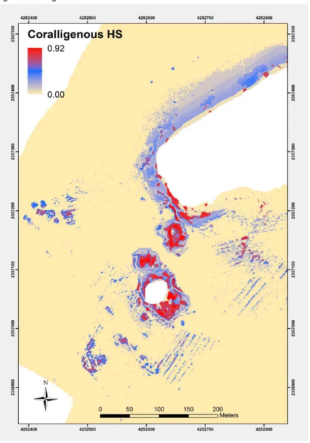
This chapter describes a conference paper presented at the 2nd Mediterranean Symposium on the conservation of Coralligenous & other Calcareous Bio‐Concretions (Portorož, Slovenia, 29‐30 October 2014), pp 183‐188”. The paper evaluate the potential of the Machine Learning Technique MaxEnt to evaluate the distribution of coralligenous environments at Portofino MPA. The model was selected because it provides a straightforward mathematical formulation to model the distribution of species based on presence only data and available habitat variables. The reason behind this selection at first glance was based on the associated difficulties to collect absence data due to the depth constraints of coralligenous habitats (‐30 to ‐150m), which therefore make the field campaign expensive to gather absence data. Results show that the method is simple and cost‐effective becoming an optimal solution for extended monitoring by the combination of innovative and new tech tools.
Chapter 5- Modelling the distribution of rocky shore indicator species and its relation to the geomorphology and anthropogenic pressures at Portofino MPA
In collaboration with colleagues from Université Nice‐Sophia Antipolis this chapter is focused on the performance of DM to map the distribution of rocky shore indicator species at Portofino MPA. Similar methodological assessments previously described in chapter 3 were used in combination with data collected by the CARLIT method and adding anthropogenic variables that could also contribute with the distribution patterns of the indicator species. Results indicated that slope,
22
rugosity and depth are the most contributing variables for Cystoseira amentacea distribution. While sites close to anthropogenic stressors are favourable for more competitive species (e.g: Ulva lactuca and Mytilus galloprovincialis). Results also shown that the species selected as indicators have proved to be appropriate for the type of pressure tackled.
Chapter 6- Guidelines for monitoring measures of coralligenous assemblages within a Management context
This chapter provided a methodological framework for the implementation of monitoring measures for coralligenous assemblages. The guideline offers a summary of the PhD document in easy and understandable steps. The aim is to inform and provide recommendations to managers and policymakers about how to best protect coralligenous resources, how to create or redefine different zones or levels of protections at Marine Protected Areas (MPAs) and how to forecast future changes due to global warming and/or anthropogenic activities. The application of the standardized methodological framework could strength management efficiency and will help to make the best decision a local scale that also take into consideration the broader regional contacts and in that way, help to achieve or maintain a GES for 2020.
References
Agnesi, S., Annunziatellis, A., Cassese, M.L., La Mesa, G., Mo, G and Tunesi, L. (2008). Synthesis of the cartographic information on the coralligenous assemblages and other biogenic calcareous formations in the Mediterranean Sea. Avenant N°3/2008/RAC/SPA en référence au Mémorandum de coopération N° 6/2002/RAC/SPA : 50 pp.+ 4 annexes.
Connor, D. (2005). EUNIS marine habitat classification: application, testing and improvement. Report of ‘‘Mapping European Seabed Habitats (MESH)’’ Project. www.searchmesh.net (Accessed 19 October 2014).
Ballesteros, E. (2006). Mediterranean coralligenous assemblages: a synthesis of present knowledge. Oceanography and Marine Biology, an Annual Review 44:123‐195.
Ballesteros, E., Torras, X., Pinedo, S., García, M., Mangialajo, L and De Torres, M. (2007). A new methodology based on littoral community cartography dominated by macroalgae for the implementation of the European Water Framework Directive. Marine Pollution Bulletin. 55, 172‐180.
23
Bandelj, V., Curiel, D., Lek, S., Rismondo, A. and Solidoro, C. (2009). Modelling spatial distribution of hard bottom benthic communities and their functional response to environmental parameters. Ecological Modelling 220, 2838–2850. DOI: 10.1016/j.ecolmodel.2009.04.024.
Borja, A., Elliott, M., Andersen, J. H., Cardoso, A. C., Carstensen, J., Ferreira, J. G., Heiskanen, A. S., et al. (2013). Good Environmental Status of marine ecosystems: what is it and how do we know when we have attained it? Marine Pollution Bulletin, 76: 16–27.
Borja, A., Prins, T.C., Simboura, N., Andersen, J.H., Berg, T., Marques, J.C., Neto, J.M., Papadopoulou, N., Reker, J., Teixeira, H and Uusitalo, L. (2014). Tales from a thousand and one ways to integrate marine ecosystem components when assessing the environmental status. Frontiers in Marine Science Volume 1: Article 72, doi: 10.3389/fmars.2014.00072.
Buhl‐Mortensen, L., Buhl‐Mortensen, P., Dolan, M.J.F and Gonzalez‐Mirelis, G. (2015). Habitat mapping as a tool for conservation and sustainable use of marine resources: Some perspectives from the MAREANO Programme, Norway. Journal of Sea Research, SEARES‐01309; No of Pages 16. DOI:10.1016/j.seares.2014.10.014.
Cerrano, C., Bavestrello, G., Bianchi, C.N., Cattaneo‐vietti, R., Bava, S., Morganti, C., Morri, C., Picco, P., Sara, G., Schiaparelli, S., Siccardi, A and Sponga, F. (2000). A catastrophic mass‐mortality episode of gorgonians and other organisms in the Ligurian Sea (North‐western Mediterranean), summer 1999. Ecology Letters 3:284‐293.
Coma, R., Pola, E., Ribes, M and Zabala, M. (2004). Long‐term assessment of temperate octocoral mortality patterns, protected vs. unprotected areas. Ecological Applications 14:1466‐1478.
Douvere, F. and Ehler, C. (2011). The importance of monitoring and evaluation in adaptive marine spatial planning. Journal of Coastal Conservation. 15:305‐311.
Dutertre, M., Hamon, D., Chevalier, C., Ehrhold, A. (2013). The use of the relationships between environmental factors and benthic macrofaunal distribution in the establishment of a baseline for coastal management. ICES J. Mar. Sci. 70‐2, 294–308. DOI: org/10.1093/icesjms/fss170.
Elith, J., Phillips, S.J., Hastie, T., Dudik, M., Chee, Y.E. and Yates, C.J. (2011). A statistical explanation of MaxEnt for ecologists. Diversity and Distributions, 17, 43‐47. DOI: 10.1111/j.1472‐ 4642.2010.00725.x.
Elsäßer, B., Fariñas‐Franco, J.M., Wilson, C.D., Kregting, L. and Roberts, D .(2013). Identifying optimal sites for natural recovery and restoration of impacted biogenic habitats in a special area of conservation using hydrodynamic and habitat suitability modelling. Journal of Sea Research 77 , 11– 21. DOI: 10.1016/j.seares.2012.12.006.
European Commission. (2006). Council Regulation concerning management measures for the sustainable exploitation of fishery resources in the Mediterranean Sea. Regulation 1967/2006, OJ L 409.
European Commission. (2011). Commission staff working paper. Relationship between the initial assessment of marine waters and the criteria for good environmental status, European Commission, Brussels, 14.10.2011 SEC, 95.
24
Galparsoro, I., Borja, A., Kostylev, V.E., Germán‐ Rodríguez, J., Pascual, M and Muxika, I. (2013). A process‐driven sedimentary habitat modelling approach, providing insights into seafloor integrity and biodiversity assessment within the European Marine Strategy Framework Directive. Estuarine Coastal and Shelf Science. 131, 194–205. DOI: 10.1016/j.ecss.2013.07.007.
García‐Alegre, A., Sánchez, F., Gómez‐Ballesteros, M., Hinz, H., Serrano and Parra, S. (2014). Modelling and mapping the local distribution of representative species on the Le Danois Bank, El Cachucho Marine Protected Area (Cantabrian Sea), Deep‐Sea Research II. 106, 151–164. DOI: .org/10.1016/j.dsr2.2013.12.012.
Garrabou, J., Coma, R., Bensoussan, N., Bally, M., Chevaldonné, P., Cicliano, M., Diaz,D., Harmelin, J.G., Gambi, M.C., Kersting, D.K., Ledous, J.B., Lejeusne, C., Linares, C., Marschal, C., Pérez, T., Ribes, M., Romano, JC., Serrano, E., Teixidó, N., Torrents, O., Zabala, M., Zuberer, F and Cerrano, C. (2009). Mass mortality in Northwestern Mediterranean rocky benthic communities: effects of the 2003 heat wave. Global Change Biology doi:10.1111/j.1365‐2486.2008.01823.x.
Gianni, F., Bartolini, F., Airoldi, L., Ballesteros, E., Francour, P., Guidetti, P., Meinesz, A., Thibaut, T. and Mangialajo, L., (2013). Conservation and restoration of marine forests in the Mediterranean Sea and the potential role of Marine Protected Areas. Advances in Oceanography & Limnology. 4 (2), 83‐ 101.
Gilbert, A. J. K., Alexander, R., Sardá, R., Brazinskaite, C., Fischer, K., Gee, M., Jessopp, P., Kershaw, H. J., Los, D., March Morla, C., O’Mahony, M., Pihlajamäki, S., Rees, and Varjopuro, R.(2015). Marine spatial planning and Good Environmental Status: a perspective on spatial and temporal dimensions. Ecology and Society 20(1): 64. http://dx.doi.org/10.5751/ES‐06979‐200164
Giusti, M., Salvati, E., Angiolillo, M., Tunesi, L and Canese, S. (2014). Predicting the suitable habitat of the red coral, Corallium rubrum (Linnaeus 1758), in relation to bathymetric variables. 2nd Mediterranean Symposium on the conservation of Coralligenous and other Calcareous Bio‐ Concretions (Portorož, Slovenia, 29‐30 October 2014), 217‐218.
Gormley, K.S.G., Porter, J.S., Bell, M.C., Hull, A.D and Sanderson, W.G. (2013). Predictive Habitat Modelling as a Tool to Assess the Change in Distribution and Extent of an OSPAR Priority Habitat under an Increased Ocean Temperature Scenario: Consequences for Marine Protected Area Networks and Management. PLoS ONE 8(7): e68263. DOI:10.1371/journal.pone.0068263.
Greathead, C., Gonzalez‐Irusta, J. M., Clarke, J., Boulcott, P., Blackadder, L., Weetman, A and Wright, P. J. (2014). Environmental requirements for three sea pen species: relevance to distribution and conservation. – ICES Journal of Marine Science. 72‐2, 576‐586. DOI: 10.1093/icesjms/fsu129.
Harris, P.T and Baker, E.K.(2012). Seafloor Geomorphology as Benthic Habitat: Geo‐Hab Atlas of seafloor geomorphic features and benthic habitats Elsevier, Amsterdam, 947.
He, H., Ferrari, R., McKinnon, D., Roff, G., Mumby, P., Smith, R and Upcroft, B (2012). Measuring reef complexity and rugosity from monocular video bathymetric reconstruction. In Proceedings of the 12th International Coral Reef Symposium, James Cook University, Cairns, Australia, pp. 1‐5.
25
Kipson, S., Fourt, M., Teixido, N., Cebrian, E., Casas, E., et, al. (2011). Rapid Biodiversity Assessment and Monitoring Method for Highly Diverse Benthic communities: A Case Study of Mediterranean Coralligenous Outcrops. PLoS ONE 6(11): e27103. doi:10.1371/journal.pone.0027103.
Lirman, D., Gracias, N., Gintert, B.E. Gleason, A.C.R. Negahdaripour, S. P. Kramer, P and Reid, R.P. (2007). Development and application of a video‐mosaic survey technology to document the status of coral reef communities. Environmental Monitoring and Assessment 125:59‐73
Mangialajo, L., Ruggieri, N., Asnaghi, V., Chiantore, M., Povero, P and Cattaneo‐Vietti, R. (2007). Ecological status in the Ligurian Sea: The effect of coastline urbanisation and the importance of proper reference sites. Marine Pollution Bulletin, 55(1), 30‐41.
Martin, C.S., Giannoulaki, M., De Leo, F., Scardi, M., Salomidi, M., Knitweiss, L., Pace, M. L., Garofalo G., Gristina, M., Ballesteros, E., Bavestrello, G., Belluscio, A., Cebrian, E., Gerakaris V., Pergent, G and Pergent‐Martini, C. (2014). Coralligenous and maërl habitats: predictive modelling to identify their spatial distributions across the Mediterranean Sea. Sci. Rep., 4, 50‐73 DOI: 10.1038/srep05073. Martínez, B., Viejo, R.M., Carreno, F and Aranda, S.C. (2012). Habitat distribution models for intertidal seaweeds: responses to climatic and non‐climatic drivers. Journal of Biogeography, 39, 1877–1890. DOI:10.1111/j.1365‐2699.2012.02741.x.
McKinnon, D., He, H., Upcroft, B and Smith, R.N. (2011). Towards automated and in‐situ, near‐real time 3‐D reconstruction of coral reef environments. In OCEANS'11 MTS/IEEE Kona Conference, 19‐22 September 2011, Hilton Waikoloa Village, Kona, Hawaii.
Mineur, F., Arenas, F., Assis, J., Davies, A.J., Engelen, A.H., Fernandes, F., Malta, E., Thibaut, T., Van Nguyen, T., Vaz‐Pinto, F., Vranken, S., Serrão, E.A., De Clerck, O. (2015). European seaweeds under pressure: Consequences for communities and ecosystem functioning. Journal of Sea Research. 98, 91‐108.
Pergent, G. (2011). Proposal for the definition of standard methods for inventorying and monitoring coralligenous and maërl populations. UNEP‐ MAP, RAC/SPA. UNEP(DEPI)/MED WG.362/4. Tunis 20p. Piha, H and Zampoukas, N. (2011).Review of Methodological Standards Related to the Marine Strategy Framework Directive Criteria on Good Environmental Status. Prepared under the Administrative Arrangement between JRC and DG ENV (no 31210 – 2009/2010) and JRC’s own institutional funding 53p.
Piroddi, C., Teixeira, H., Lynam, C.P., Smith, C., Alvarez, M.C., Mazik, K., Andonegi, E., Churilova, T., Tedesco, L., Chifflet, M., Chust, G., Galparsoro, I., Garcia, A.C., Kämäri, M., Kryvenko, O., Lassallei, G., Neville, S., Niquil, N., Papadopoulou, N., Rossberg, A.G., Suslin, V and Uyarra, M.C., 2015. Using ecological models to assess ecosystem status in support of the European Marine Strategy Framework Directive. Ecological Indicators, 58, 175–191. DOI:10.1016/j.ecolind.2015.05.037.
Stelzenmüller, V., Rogers, S.I., Mills, C.M. (2008). Spatio‐temporal patterns of fishing pressure on UK marine landscapes, and their implications for spatial planning and management. ICES J. Mar. Sci. 65, 1081–1091. doi:10.1093/icesjms/fsn073
26
Reiss, H., Birchenough, S., Borja, A., Buhl‐Mortensen, L., Craeymeersch, J., Dannheim, J., Darr, A., Galparsoro, I., Gogina, M.,Neumann, H., Populus, J., Rengstorf, A. M., Valle, M., van Hoey, G., Zettler, M. L., and Degraer, S., 2015. Benthos distribution modelling and its relevance for marine ecosystem management. – ICES Journal of Marine Science, 72: 297–315. DOI:10.1093/icesjms/fsu107.
Rice, J., Arvanitidis, C., Borja, A., Frid, C., Hiddink, J.C., Krause, J., Lorance, P., Áki Ragnarsson, S., Sköld, M., Trabucco, B., Enserink, L and Norkko, A. (2012) .Indicators for Sea‐floor Integrity under the European Marine Strategy Framework Directive. Ecological Indicators 12, 174–184. doi:10.1016/j.ecolind.2011.03.021.
UNEP‐MAP‐RAC/SPA (2008). Action plan for the conservation of the coralligenous and other calcareous bio‐concretions in the Mediterranean Sea. RAC/SPA, ed. Tunis: RAC/SPA. pp 21
Valle, M., Garmendia, J.M., Chust, G., Franco, J and Borja, A.(2015). Increasing the chance of a successful restoration of Zostera noltii meadows. Aquatic Botany 127, 12‐19. DOI:10.1016/j.aquabot.2015.07.002.
Van Rein, H., Schoeman, D.S., Brown, C.J., Quinn, R and Breen, J. (2011). Development of benthic monitoring methods using photoquadrats and scuba on heterogeneous hard‐substrata: a boulder‐ slope community case study. Aquatic Conserv: Mar. Freshw. Ecosyst. 21: 676–689.
Zapata‐Ramírez, P.A., Blanchon, P., Olioso, A., Hernandez‐Nunez, H., Sobrino, J.A. (2013a). Accuracy of IKONOS for mapping benthic coral‐reef habitats: A case study from the Puerto Morelos Reef National Park, Mexico, Int. J. Remote Sens. 34 (9‐10), 3671‐3687. DOI: 10.1080/01431161.2012.716922.
Zapata‐Ramírez, P.A., Scaradozzi, D., Sorbi, L., Palma, M., Pantaleo, U., Ponti, M., Cerrano, C. (2013b). Innovative study methods for the Mediterranean coralligenous habitats. Advances in Oceanography and Limnology 4:102‐119
27
Chapter 1
Innovative study methods for the Mediterranean coralligenous habitats
Abstract
Coralligenous habitats are of special interest in the Mediterranean Sea because they represent one of the most important biodiversity ‘hot‐spots’ and are considered of great relevance for fisheries activities in the region. Despite their importance, however, there are missing consensual methodologies for their monitoring and, despite some attempts, no environmental or ecological quality indices have been established yet. This situation could be related to the difficulties associated with their exploration and their spatial heterogeneity. These habitats are in urgent need of efficient standard monitoring and management protocols programmes to develop an effective network for their conservation. Here we reviewed the available methodologies and robotics tools used to evaluate and monitor benthic habitats, highlighting the importance of defining rapid cost‐effective sampling and analyses approaches and architectures for future monitoring of changes in coralligenous habitats based on current technological developments. We identified still images acquisitions as the most effective data gathering system. Stereo photogrammetry, photomosaic elaboration and three‐ dimensional (3D) modelling may largely improve the data analysis and therefore the quality status assessment of the coralligenous habitats. The advantage and efficiency of different approaches and methods, and whether they should be applied and standardised for further monitoring activities, were discussed.
Keywords: quality status; underwater mapping; impact assessment; Mediterranean. PUBLISHED
Zapata-Ramírez PA, Scaradozzi D, Sorbi L, Palma M, Pantaleo U, Ponti M, Cerrano C (2013). Innovative
study methods for the Mediterranean coralligenous habitats. Advances in Oceanography and Limnology 4:102‐119
28
1. Introduction
The Mediterranean Sea is an attractive region with 70 million inhabitants concentrated in its coastal cities with an additional 175 million tourists visiting every year as a holiday destination. This crowd generates important financial gains, but also places drastic pressure on marine ecosystems. The 46,000 km of coastline of the basin hosts key habitats such as meadows of Posidonia oceanica, down to 40–50 m in depth, mainly on sandy bottoms, and coralligenous assemblages, which form biogenic rims and banks down to 130 m depth [1]. In particular, coralligenous habitats are of special interest in the Mediterranean Sea because they represent a key spot of biodiversity, hosting around 20% of the Mediterranean species, and having great structural and functional complexity [1]. These habitats are also considered of high relevance for fisheries activities in the region. They result from a multi‐ stratified accretion, made of macroalgae and invertebrates’ mineral skeletons, under a dynamic equilibrium between builders (i.e. rhodophythes, scleractinians, bryozoans, serpulids, etc.) and borers, represented mainly by clionaids and allied sponges [2,3]. Whenever either of these actions prevails, it favours the accretion or the erosion of these bioconstructions respectively.
Radiocarbon analyses allowed the initial formation of these bioconstructions to be dated back to the early Holocene or to the late Pleistocene periods. They seem to appear during the last great transgression, caused by the general increase in temperature at the end of the warm period [4]. The species that dominate coralligenous seascapes are encrusting calcareous algae, sponges, cnidarians, bryozoans and tunicates [1,5]. Some of these species are slow growing (e.g. red coral 0.006–0.83 mm year 1) with high longevity [1,6,7] and they give high stability to the whole assemblage, especially regarding edaphic conditions. Therefore the complexity of this community involves a vulnerability to various disturbances such as destructive fishing practices, pollution, diving, storm impacts associated with climate change, invasive species, ocean acidification or mass mortality outbreaks [8–13]. Bottom trawling and artisanal fishery, in particular, have been shown to damage
29
or destroy long‐lived erected invertebrates such as corals and sponges, harming the three‐ dimensional complexity of the seabed, and subsequently reducing species diversity and faunal biomass [14–15]. The disturbance due to mass mortality outbreaks has become more frequent since 1999, affecting more than 30 benthic species (mainly filter feeders) over hundreds of kilometres of the NW Mediterranean coast [8,11,16]. There are different studies that have provided information on the effects of these impacts [7,9,11,17–22]. However, there is little quantitative information of the mortality rates of these groups, and changes in the community regarding the coralligenous composition and coverage of different species. Clearly, there is an urgent need to improve the scientific background that will underpin policy decisions concerning the sustainable management of coralligenous habitats. The Mediterranean basin requires such decisions to be taken in line with its strategic objective of sustainable development (e.g. European Habitat Directive, 92/43/EEC; Barcelona 2000; Water Framework Directive, 2000/60/EC, Marine Strategy Framework Directive, 2008/56/EC), and its global commitments to the Convention of Biological Diversity (Rio, 1992). These initiatives have to meet the challenges of efficient monitoring and management programmes to sustain their biological, economic and cultural values for the global community. An action plan for the conservation of the coralligenous and other calcareous bioconcretions in the Mediterranean Sea was established in the framework of the Barcelona Convention [10]. The first step in managing any threat is to understand it. A barrier to development of management plans in coralligenous habitats is that their distribution remains poorly characterised because they have not been mapped with sufficient accuracy and with spatial resolutions high enough to support their efficient management and conservation [23–25]. Even if we have an overall knowledge about the composition of the Mediterranean coralligenous assemblages [1,24,26], the absence of cartographical data and associated species on the overall distribution of these assemblages is one of the greatest lacunae from the conservation point of view [23,27]. Most of the cartographic information is based on surveys carried out in the north‐western Mediterranean Sea [e.g. 25,28] and there is an evident lack of data and a poor representation of these habitats in the southern and eastern Mediterranean Sea
30
[29]. This situation could be related to the difficulties associated with their exploration, their spatial heterogeneity and with the limited means of investigation. Current research on coralligenous habitats often lacks coordination, consensual monitoring and effective environmental or ecological quality indices [5,25,30–32]. Furthermore, the fragmented geopolitical scenario characterising the Mediterranean basin still leads to weak, uncoordinated, conflicting approaches, and there are not existent regulatory frameworks, policy mechanisms and enforcement [27].
Knowledge of the distribution, biodiversity and its relation with functioning of the coralligenous habitats is therefore crucial for providing information relevant to the identification and implementation of technical options and for their conservation and sustainable use [31]. In order to address this management requirement and to set up effective management and protection schemes, there is an urgent need to develop robust methods for mapping these habitats and to establish their geographical location, extent, and condition. High quality benthic/habitat maps, both at a regional scale [e.g. 23], indicating assemblage occurrence within the Mediterranean basin, and at a more local scale [e.g. 33] detailing the spatial distribution of coralligenous vitality and status (pristine vs. damaged) are essential. Further development of predictive habitat mapping techniques is also necessary to guide the exploration for the known and the unknown coralligenous areas around the Mediterranean basin. In addition, as management schemes become established, it will become important to follow‐up the coralligenous status and recovery with repeated surveys (e.g. monitoring) and habitat mapping efforts [31]. The results of the mapping efforts in these environments would provide clarity and coordination among plans to better inform decision makers. Thereby, the review attempts to evaluate the advantages and efficiency of different approaches and methods used to map and monitor benthic habitats and whether they should be applied and standardised for further coralligenous monitoring activities
31
2. Classic survey methods
Ever more sophisticated methods have been used to study and map the benthic environments (eg. [30, 34]). Classic survey methods in marine hard bottoms include visual transect (using chain or measure tape) or quadrats (e.g. [35]). In coralligenous habitat they have been mainly used to estimate species diversity and assemblages structure (e.g. [6]), demographic parameters and to study the short and long term changes in gorgonian populations (e.g. [9, 36, 37]). These studies recommended a quarter to one square meter frames to monitor abundant large‐sized organisms growing at the coralligenous outcrops. Technical information regarding these survey methods and comparisons between them has been reviewed adequately and at length elsewhere (see: [38‐44]). As well, information regarding their cost, time required, accuracy, precision and statistical power has been also evaluated in detail [39]. In general, these visual methods provide a high taxonomic accuracy, yield a good estimate for small or rare species, are easy to implement and have a low cost. However, limitation of the methods has been also addressed, such as the need of very well trained observers, small investigated area and the limited operative depth due to divers safety reasons. Moreover these methods cannot be used to measure three‐dimensional complexity, since they are not well suited to characterise the holistic features of natural landscapes, and measurements are prone to dramatic variation with minor changes on the adopted tools placement [45].
According to Van Rein et al. [34] more research in standardising methodologies has been conducted within tropical latitudes than in temperate latitudes, largely due to differences in survey environments, target communities and operational budgets. However, this accumulated wealth of knowledge in the tropics in some cases may be transferred to temperate areas. For instance, as happen for tropical coral reefs, despite the well‐known and obvious differences between those environments, both coralligenous and coral reefs accretions are characterised by a photosynthetic growing side and by a shaded side, colonized mainly by heterotrophic filter feeders, among which several bioeroders (e.g. sponges and bivalves). In case of healthy conditions of the biogenic structures, a high spatial complexity can be reported, otherwise, in case of damaged conditions,
32
complexity decrease shifting towards a more trivialised system. In damaged coral reefs, physical and biological processes of erosion overcome bioconstruction and the percentage covered by coral rubble and sediment increase [46]. In temperate coralligenous systems, the rugosity of the coralligenous concretions enhances sediment deposition [47]. For coral reefs, high sedimentation rates can smother the living organisms, compromise the reef accretion [48]) and limit the community renewing by new settlers [48]. In coralligenous habitats the mechanical disturbance [9], sedimentation increase [49], species invasion [50], temperature increase and water degradation [51] have all negative effects on species assemblages. However, coral rubble and limited sediment deposition may contribute in the following building up of the new frameworks through complex processes of lithification [52].
3. Underwater Mapping: state of the art
During the seventies conventional coral reef maps were based on field data obtained by planimetric surveys and visual observations [53]. Rapid development of remote sensing techniques has opened a new avenue for seamless mapping of biodiversity at different scales. Remotely sensed data has the potential to provide a broad‐scale synoptic view of benthic environments and provide temporal data that may be used to assess events in community dynamics [54,55]. In addition to these advantages, using remote sensing techniques, the data are collected from a sensor without really impacting or creating disturbances on the seabed [56–58]. These advances have led to the development of new approaches to biodiversity measurements, including the use of indirect abiotic proxies, statistical modelling, remote sensing and a combination of these [59].
3.1 Acoustic sensors
Acoustic technologies are increasingly being used for monitoring benthic habitats. The data have been analysed with means of dedicated software and geographic information systems (GIS) to extract different acoustic classes, which in turn have been applied to the identification of seafloor
33
habitats [34,57,60]. In the case of coralligenous habitats, the acoustic technologies normally include side‐scan sonars and multibeam sonars (e.g. [61,62]), eventually coupled with observations by scientific divers and/or remote‐operated vehicles. For instance, Barber_a et al. [28] describe the benthic habitats located at the Menorca channel. The study was carried out with side‐scan sonar, a remote‐operated vehicle and an underwater drop camera. The techniques were used to map the habitat distribution between 50 and 100 m depth, to make an inventory and describe the spatial patterns of both the specific and functional diversity in the area. Results obtained with this research show evidence that trawling intensity affects coralligenous environments in the study area. Gordini et al. [61] used side‐scan sonar, and multibeam technologies to characterise a set of submarine rock outcrops in the Northern Adriatic Sea. By means of these technologies, the authors reported coralligenous concretions in the area and highlighted the importance of these habitats in the origin of the rock outcrops. Bonacorsi et al. [62] collected side‐scan sonar and multibeam data in the Western Mediterranean Sea. The authors discovered a new coralligenous morphotype (‘coralligenous atolls’) with the data obtained from the side‐scan sonar. Finally, the study leaves open the hypothesis that the origin of these ‘atolls’ could be related to gaseous emissions in the region. However, despite the advantages of the acoustic technologies in marine ecosystems, these methods are unable to discriminate benthic communities based on pigmentation [57] and do not provide any photometric information to obtain three‐dimensional (3D) textured visual maps [63]. In addition, these methods cannot resolve fine scale structure due to the resolution of the survey data [45] and often the acoustic records require interpolation methods for mapping the area of interest. Another important disadvantage is the price of the implementation, still very high, although these technologies become accurate, light, easy and cheap day by day. Reducing the cost for acquisition of data is a key priority in order to implement European Union (EU) legislations such as the Marine Strategy Framework Directive.
34
3.2 In situ optical methods
Despite the advantages of remote sensing in marine ecosystems, in situ measurements remain the most important and reliable source of information on biodiversity [59]. There has been a sharp increase in recent years in the use of digital devices in marine benthic environments [39]. Optical‐ based methods (i.e. digital video and stills cameras) are becoming more commonly used in research because they collect data quickly reducing the time spent underwater, provide high‐resolution images of the organisms, and cover large areas quickly [44,64,65]. In addition, they generate permanent survey records, achieve greater sampling objectivity than traditional diver observations and have a low environmental impact in sensitive areas of conservation importance [64,66,67]. Photographic methods have been applied in coralligenous environments at regular time intervals in fixed sites in order to measure individual growth, mortalities, disease development and recovering processes [68]. Moreover, images of benthic assemblages can provide information on species abundances and species diversity, by means of dedicated image analysis software [e.g. 69,70]. Ferdeghini et al. [71] used a visual estimate approach with a multi‐factorial sampling design to assess patterns of vertical distribution on coralligenous environments at the Giannutri Island (Tuscan Archipelago, Northwest Mediterranean).
The study found a high heterogeneity in the distribution and abundance of the analysed taxa. The authors attribute these results to the smallest spatial scale investigated (10’s of m). Certainly, Prada et al. [72] stated that the scale at which ecological processes operate, and the scale at which organisms perceive (or respond to) the heterogeneity of the ‘seascape’ are often determining factors in choosing the resolution at which a habitat should be mapped. Therefore, under‐sampling can cause information loss in a spatial domain, especially when there is a discontinuous distribution of elements or when the sample frequency is too low to capture the fundamental signal pattern [73]. Recently, Deter et al. [69] addressed this disadvantage proposing a rapid photographic method to estimate the percentage cover of sessile organisms. The authors identified that 64 photographic
35
quadrats on stratified random points (RQ) and at different depths is a good method to estimate abundance in coralligenous environments. For the photographic analysis, the study used and adapted the CPCe (Coral Point Count with Excel extensions) software to be used in coralligenous environments (CPCe 4.1 ‘coralligenous assemblage version’). The software reduces the time spent (image preparation and analysis) for RQ by grouping in a unique interface picture enhancement, point distribution and identification. Nevertheless, the authors stated that the method should be avoided when a total species inventory is necessary or when species richness is the variable of interest because species that cover less than 4% could be missed. In addition to this disadvantage, the precision of this method depends on the sampling frequency during the monitoring plan and the ability to take photos from exactly the same spot. Kipson et al. [5] attempt to provide guidelines for the application of a rapid, non‐destructive protocol for biodiversity assessment and monitoring coralligenous environments. The method searches for a way to assess the natural spatio‐temporal variability of coralligenous outcrops. To achieve that aim the authors propose a photographic sampling method based on the determination of the presence/absence of macrobenthic species. However, and taking in account the recommendations of [25], the monitoring methods should not be based on presence/absence or restricted number of target species. Another limitation of these methods is the impossibility to identify changes at a landscape level with which to determine the impacts of coralligenous stressors at these scales. In addition to these constraints, Reid et al. [74] found that when using the photo‐quadrats method for mapping activities, the repeatability (tracking changes over time) requires that several permanent markers be deployed per image during the post processing step, which is tedious to set up and easily disturbed.
4. Photo and video mosaicing technologies
Several studies have demonstrated the value of using photographic or video techniques to evaluate benthic habitat conditions; nevertheless these types of surveys allow studying limited benthic areas and are affected by visibility and lighting factors [75]. As a result, these surveys are spatially and
36
temporally sparse [66,76]. Accordingly, these disadvantages restrict our understanding of the mechanistic processes occurring at different scales in benthic environments. Photo – video mosaicing presents itself as a suitable technique to overcome these limitations [66,67,75,76]. Basically, photo – video mosaicing is defined as the process that merges several images of the same scene into a single and larger composite [75,77]. In the case of the marine environment, either divers deploy underwater cameras or underwater vehicles acquire images of the area of interest [63]. According to Van Rein et al. [65] the potential of the method lies with being able to create images of the seabed while maintaining high image resolution. The images can provide information in both, landscape level (metre‐scale) maps and high‐resolution (sub‐millimetre) images of individual colonial organisms [74]. In addition and due to the recent advances in optical imaging systems coupled with precision navigation [78–80], the mosaics can be easily georeferenced providing a precise positioning of the environment, allowing mapping and monitoring activities [e.g. 67,81,82]. They can be integrated with other data sets using GIS such as those obtained by acoustic technologies. Therefore, the integration of the whole set of data allows the assessment of the relationships between seafloor depth, morphology and organism distributions [83]. This information can then be used to test hypotheses related to the distribution of benthic habitats that could also inform further surveys and sampling activities [79].
4.1 2D mosaicing reconstructions
First‐generation mosaics (resolution in the order of 3–5 mm pixel _1) were developed by Lirman et al. [67] to construct two‐dimensional (2D), spatially accurate, high‐resolution mosaics of the reef benthos in Florida. The mosaicing method was able to discern broad benthic taxonomic categories such as stony corals, octocorals, algae, sponges, and sand. The two dimensional images were analysed by the author with the same methods commonly used by divers to estimate in situ the percentage of cover (point intercept method). Despite these advances, first‐generation mosaic products were insufficient for species level identification of many benthic taxa, thereby limiting the