HISTORICAL ASSETS ANALYSIS IN HERITAGE SITES FOR
CULTURAL LANDSCAPE MANAGEMENT
Case Studies of Aristocratic Estates from Italy, France and Spain
Supervisor: Prof. Mauro VOLPIANO
Co-Supervisor: Prof. Claudia CASSATELLA
Student: Elif SEZER
S261286Planning for the Global Urban Agenda - Territorial, Urban, Environmental and
Landscape Planning
Planning and Design
Politecnico di Torino
Acknowledgement
I would first like to thank my supervisors Professor Mauro Volpiano and Professor Claudia Cassatella for their guidance and feedback throughout this research. I would like to extend my sincere thanks to my colleagues and tutors from the workshop who contributed highly in the specific parts of this research paper.
I am also grateful to my friends who have always supported me with their existence since the beginning of my master's education. Special thanks to my dear boyfriend Francesco Niosi my precious friend Buğrahan Çoban, who are my biggest supports in Italy.
Finally, I must express my very profound gratitude to my parents Nayim and Ayşen Sezer, my dear sister İpek Sezer and Niosi family for their unwavering support and patience that cannot be underestimated.
Table of Contents
Abstract
1. Introduction ... 5
2. Literature Review ... 8
3. Research Design and Methods ... 11
4. International Documents and Regulations on Cultural Landscape ... 26
5. Historical Landscape Studies ... 27
6. Reviews of Case Studies ... 29
7. General Comparisons Among The Case Studies ... 107
8. Conclusion………..109
Abstract
Although heritage landscape is one of the main titles that make up the landscape assessment, broadly speaking it has been overshadowed by rural development policies due to economic concerns. In recent years, even if more emphasis has been placed on this subject, especially with the European Landscape Convention, it is still difficult to talk about a common language and approach which is usable and transferable among heritage landscape studies . In this study, heritage landscape practices were examined on 3 aristocratic estate samples selected from among European countries, and heritage landscape analyses prepared for these estates and their environment or estate networks were compared. Examples are Royal Residences of Savoy located in the north of Italy, Versailles Palace which is one of the most important royal estates in France and the surrounding urban and territories of the Palace, and finally Cultural Landscape of Aranjuez in the Madrid Region of Spain and the royal estate network to which it belongs. As each country has its own methods, there are also international criteria that it must comply with, such as Unesco and European Landscape Convention. Besides, all three-sample country has the Napoleonic institutional structure which makes them comparable in terms of their development policies and practices.
In this research, which were created as a result of these criteria and countries' own practices and experiences, it was examined which landscape elements were evaluated and how these elements were displayed, and then, without going too deeply, how these studies reflected in the planning practice of countries were discussed. The historical landscape studies of these heritage sites, which are largely surrounded by rural territories, are also closely or remotely related to agricultural activities. In the first part of the research, the results of the "Designing Resilient Heritage Estate Landscapes for Borgo Cornalese" study conducted by TU Delft and Politecnico di Torino were shared. This work includes the work on a small hamlet in the Piemonte region in the north of Italy, where the royal estate and rural activities are combined. Although the scale is different from the examples in the second part of the research, this study is mostly a case study in which heritage landscape assessment practice has been experienced from the beginning to the end. Thus, the practicality of the proposed categories had been experienced during this workshop. In the continuation of this study, there is the idea of creating development policies in the workshop territory.
1. INTRODUCTION
Landscape, hence historical landscape is handled in diverse ways in European countries. The approach of Northern countries as Germany, the Netherlands is more nature-based and ecology-weighted, while the approach of southern European countries as Italy and Spain is more interested in the traces of human transformations and culture. Still, there is a common vision on landscape management as integrating nature and culture, considering the whole territory instead of separated sites, develop sustainable management systems, and so on (Scazzosi L., 2004).
While the world is concerned with the sustainable management of landscape examples and the elements that make them unique, countries have developed their own approaches from Asia to Europe and America. But there are certain common difficulties as defining the right interpretative categories and analytical components of the landscape or grouping these items and making them transferrable to the other analyses which concern all these countries in this process.
Especially for conservation and management of European Heritage, the Council of Europe constituted the “European Landscape Convention” and organizes international co-operation on landscape issues. But still, these countries have different institutional models and practices from each other. The sample countries of this research are involved in the convention and share similar concerns as integrating landscape in their spatial planning systems or avoiding the boundaries for the benefit of continuity of cultural landscapes (Schröder et al.).
The development of cultural landscapes, conservation of natural and historical landscapes are issues that have been discussed and studied for a long time in Europe. Although common key terms and concepts are shared among the countries thanks to the convention, significant diversity occurs when it comes to the application, especially in the mapping/illustration and objective setting processes. Since a reason for this diversity could be the lack of consensus on the indicators, especially on historical landscape studies, this research is mostly concentrated on the questions of:
- Which are the analytical components and interpretive categories used in historical interpretation practices?
- Which are the relations between these analytical categories and intervention categories? - How it is possible to group these items into analyses criteria and transfer to the other studies
Along with the issue of analytical components, another critical issue is the relationship of these studies with the planning practices. Mutually, the effects of planning studies with historical landscape studies were briefly examined. Consequently, the European Landscape Convention is not only helping coordinate collaboration in understanding and planning for valuable landscapes but also offers a valuable tool for comparing landscape planning approaches in Europe.
The landscape convention recommends two methods for the implementation process of its articles; joining landscape studies into existing spatial planning or setting up a new system called landscape planning. For the member countries, it was unclear how to follow these
recommendations and integrate landscape studies into their planning systems. For example, countries as the Netherlands and Germany have already had “landscape plans” on various levels which were inspiring for the planners in the UK (Schröder et al.). Apart from landscape planning practices, Anglo-Saxon countries have many guidelines for the assessment and implication such as agencies and ministerial methods.
Understanding historic landscape character is an increasingly important part of planning and countryside management (Rippon, 2013). Specially to preserve the cultural heritage, historical landscape assessment is a fundamental tool in the planning process (Foard G., Rippon S., 1998). Due to these reasons, the “European Framework”, in other words, the perspective of the member countries on “landscape studies” is a critical issue to analyse.
To make a review and research of the above-mentioned issues, this research paper is divided into two parts.
a. “Designing Resilient Heritage Estate Landscapes” workshop
The first part focuses on the “Designing Resilient Heritage Estate Landscapes” thesis atelier which was conducted together with the Polytechnic University of Turin and TU Delft. The primary aim of this workshop is to identify the challenges to the resilience of the hamlet Borgo Cornalese, which are related to its environmental features and landscape characteristics. In order to identify the challenges, a systematic analysis was made by the research group formed by master students and professors of the Polytechnic University of Turin.
b. Historical Analyses for Cultural Landscape Management Through Selected Aristocratic Estates
In the second part, three different aristocratic estates whose historical values and uses are similar and allow for comparison, are chosen to investigate the approaches of different European countries and their identification, interpretation, and assessment methods. While selecting these examples, it was taken into consideration that each of them is on the UNESCO world heritage list, the example countries have similar institutional models to each other and also all case studies are big royal estates located in rural sites which makes them technically similar to each other in terms of comparison.
The examples are Royal Residences of Savoy located in the north of Italy, Versailles Palace which is one of the most important royal estates in France and the surrounding urban and rural territories of the Palace, and finally Cultural Landscape of Aranjuez in the Madrid Region of Spain and the royal estate network to which it belongs.
Due to, the discussion on the definition of “landscape” has continued, this research paper mostly focuses on the practices and already existing studies and the methodologies that selected countries have used while preparing the plans and atlases for the case studies.
The desired outcomes from this research are a structured comparison of analytical keys related to the selected documents, a proposal of groups of categories and the usability and transferability of these groups of categories. In accordance with the purpose of the research, the method practiced in the first part is associated with the practices of the selected countries in the second part, and as a result, a general guideline including categories to use in heritage landscape analyses is created which is usable through the transition from regional to local scale.
c. Why Italy, France and Spain
History illustrates that Europe is a dynamic and evolving entity with many faces, multiple identities, multiple expressions, experiences and diversified cooperation forms (Dainotto, R., 2007). Europe is a two-thousand-year civilisation with a multiplicity of cultures; it is also a socio-economic model and a unique integration process. The whole European history is characterised by forms and attempts of economic, political, military, and cultural cooperation to search for equilibrium between integration and diversity within certain contours (Chandler, M., 2016). This common culture, formed by the combination of differences, has left many legacies until today. For example, there are different institutional models in Europe which influence the planning practise directly. According to the first ‘comparative study’ of spatial planning systems in Europe in the late 1980s, the typology of spatial planning systems of Italy, France and Spain are in the same category named “Napoleonic Codes” (Davies et al., 1989). This means they all have a complete set of abstract rules and principles in advance unlike the system of UK which is called common law. This difference on spatial planning systems of these countries also illustrates the difference on their historical interpretation practices such as their analysing process.
Like every value or assets, historical heritage values are evaluated in a classification and included in planning ideas. While this evaluation process is more systematic in other landscape elements such as agriculture, a common language has not yet been established in historical landscape elements. However, studies on bringing together European countries such as the European Landscape Convention on this issue are ongoing. This study concentrates on the European examples to investigate their practices in the heritage field and the relation among the planning decisions and heritage landscape analyses.
d. The Importance of European Policies Related to Economic Reasons on Landscape
Organizations that produce international policies, such as OECD1, often put greater effort on
agricultural landscapes and elements than on historical heritage landscapes due to economic concerns. For example, the rural policies (Understanding Rural Economies, Rural Policy 3.0) and agriculture-centred development policies. Regarding indicators, "agricultural landscape indicators" can be easily accessed as a policy development tool in OECD sources when searching about the theme landscape. But for the heritage landscape elements are included only by as “cultural features” of the landscapes and it is difficult to talk about certain indicators concerning heritage.
On the other hand, European Union is funding especially the rural and agricultural development policies and actions in terms of sustainable and local development. There are cooperation and organisations as LEADER2 funding by ENRD3 or by other similar European
organisations. With the idea that local and rural development policies are supporting the economical and sustainable development of the regions, many academic assessment studies have been done on rural and agricultural landscapes elements and their indicators. However, the assessment of heritage landscape and the related indicators are not systematic as rural landscapes. Based on this motivation, heritage landscape analyses and practices of certain countries are examined in this research paper.
1 Organisation for Economic Co-operation and Development 2 Liaison entre actions de développement de l'économie rurale 3 The European Network for Rural Development
2. LITERATURE REVIEW
The landscape covers a wide range of meanings and contexts as a term which after years of discussion, even today, there is no consensus as to the contents and meaning of it (Bastian et al. 2013). The understanding of landscape differs between languages, interest groups, and academic backgrounds (Palang et al. 2006). According to the European Landscape Convention, "landscape" means an area, as perceived by people, whose character is the result of the action and interaction of natural and/or human factors.
Alike the term “landscape”, also to the term “cultural landscape”, various meanings and concepts are attributed. Although the formations described by “cultural landscape” date back to older times, the emergence of the term itself occurred in the early 20th century. Prof. Carl Sauer promoted the definition “The cultural landscape is fashioned from a natural landscape by a culture group. Culture is the agent, the natural area the medium, the cultural landscape the result” in 1925 but until the 1990s, it only came into accepted professional use in conservation circles (Fowler, 2003). Among different names used for cultural landscapes, the one “traditional landscapes” which is common in Europe, was described as “…landscapes which have evolved over the centuries until the fast and large-scale modern changes in the ‘tabula rasa’ style started… These changes deform the traditional structure which reflects clear relations between composing elements and has a significance for natural, cultural and aesthetic value” (Antrop 2000, p 21-22)
Due to, human interaction with the land is the fundamental element for cultural landscape, conservation of local cultures, and maintain sustainable development in these areas are the main objectives for the conservation of European Heritage. For this purpose, the Council of Europe introduced “The European Landscape Convention” which promotes the protection, management, and planning of the landscapes and organizes international co-operation on landscape issues. One of the main ideas of the Landscape Convention is to set a great store by identifying and assessing landscapes through field research by professionals working in conjunction with local inhabitants. However, the governing idea is to exchange experience and methodology of landscape identification and assessment between the countries and increase the knowledge (Council of Europe).
Studies, carried out to preserve common heritage and landscape according to the European Landscape Convention, have revealed different practices in this field. In the planning system of sample countries, the convention is a binding element for landscape planning but their approach to the topic varies.
In the Convention, not only “landscape” is clarified as a term but also the actions and policies are explained from a general perspective. For example, the landscape policies are defined as the taken specific measures to protect, manage and plan of landscapes. Besides, landscape planning in the convention is described as ‘strong forward-looking actions to enhance, restore or create landscapes (Article 1f)’. But this definition does not cover all the wide range of activities done under planning titles. Most particularly, in Dutch tradition of landscape planning, there is always a bias towards the ‘creation’ of landscapes. So, the ‘creation’ in the definition of planning can be seen as ‘development’ of the space which is done almost every 20 year. Specifically, in the Dutch lands, these developments and investments are reconstruction of intensive agriculture, nature developments and ecosystem services.
(Haaren, Albert and Galler, 2016). Thus, it can be seen that the landscape planning approach differs from country to country. In the European Framework, landscape planning is sometimes used as a component of environmental planning or spatial planning. In this planning system, where environmental and nature titles are at the forefront and the objectives are set for rural planning and economic developments, it has been thrown the historical and cultural landscape studies out of focus. For this reason, in Europe, landscape studies and researches are mostly done on rural and natural related topics, where it is not prevalent to encounter a common developed understanding of historical landscape studies.
To state more clearly the common approach of Europe to landscape management, the report created at the end of the Landscape Character Network Workshop, which was held in Birmingham in 2008 and attended by academics involved in the convention, can be examined. For the management of landscape, there are 7 actions in that report which were underlined by Michael Dower, who was involved in the convention. They are;
. to identify landscapes . to assess the landscapes
. to define objectives for landscape quality . to protect
. to manage . to plan . to monitor
Identification and assessment from the actions mentioned above is causally related to the common key term catalogue desired to be obtained as a result of this research. The explanation of these two actions are that;
. to identify landscapes, that is to describe their character and the key elements in that character
. to assess the landscapes, that is to analyse what contributes to, and what detracts from, their quality and distinctiveness.
Landscape assessment is a sectoral process as ecological, agricultural, cultural (historical), social and so on. For instance, global organizations as the United Nations and the OECD have their environmental reporting for sustainability which is related to agricultural and rural policies, so their evaluation system concerns the natural and environmental values and landscape elements. Concerning the economic return of these sectors, today there are various applicative experiences dated back to the 1960s.
ELC and the Legislative Decree 42/20044 place landscape planning at the center of
protection policies, extending its range of action not only to contexts of exceptional value, but also, for the first time, to the landscapes of life daily and degraded ones, to be redeveloped and enhanced.
In France, the studies, concerning landscape, have been done under the name of La
Directive de protection de mise en Valeur des Paysages (DPMVP) “The Landscape Development Protection Directive”, which aims to protect and enhance areas remarkable for their landscape interest. DPMVP determines the guidelines and fundamental principles for the protection of landscape structures for territories of remarkable character:
• by their unity and coherence,
• by their particular wealth in terms of heritage
• or as witnesses to lifestyles and dwellings or to industrial, craft, agricultural, and forestry traditions and activities.
The development of this directive is the subject of consultation with all the local authorities concerned and is approved by decree in the Council of State.
In Italy, the regional landscape plan is an urban planning instrument provided for by the
legislation drawn up by the Region jointly with the Ministry for Cultural Heritage and Activities. This act pursues the purpose of protecting, both in terms of conservation and preservation and use and enhancement, of specific categories of territorial assets such as mountain areas, lakes, volcanoes, rivers, coastal territories, parks and reserves, woods, and the like.
The landscape plans, with reference to the territory considered, recognize its peculiar aspects and characters, as well as the landscape characteristics, and delimit the relative areas. With reference to the hierarchical order of urban planning instruments, the landscape plan prevails over national and regional plans and programs and over other planning acts with territorial impact (Sentenza n. 180 del 2008 della Corte Costituzionale).
In Spain, The Ministry of Culture and Sports is the main administrative unit responsible for
historical heritage. For the protection and management of the historical heritage sites, the ministry collaborates with the Ministry of Foreign Affairs, European Union and Cooperation. Cultural Landscape is defined in the National Plan as the "result of the interaction in time of people and the natural environment, whose expression is a territory perceived and valued for its cultural qualities, product of a process and support of the identity of a community". The National Plan for Cultural Landscape was approved at the session of the Historical Heritage Council held in Madrid on October 4, 2012.
There are different regulations and public policies on cultural heritage landscapes in Spain. The international ones are UNESCO5 and Council of Europe (European Landscape
Convention, Florence 2000). There are also national6 and a regional7 regulations. For the
Spanish case study, there is no specific regional law on landscape management and protection, but the “Aranjuez” is a UNESCO World Heritage Site, as the other examples from France and Italy.
5 Convention on The Protection of The World Cultural and Natural Heritage Paris, 1972 6 Ley 16/1985. Patrimonio Histórico Español
3. RESEARCH DESIGN AND METHODS
a. Aim & Objective The reading and assessment of permanencies in urban areas and
single architectural manufacts is quite well set up in Italy and in other countries. However, landscape reading still demands the clarification of concepts and methodologies, by further theoretical and experimental work (Scazzosi, 2004). This research aims to analyse the case studies to generate knowledge on the given topic. Instead of methodological comparison of the historical landscape analysis among these countries, the research will focus on the practices by comparing the interpretations, the legends were used to guide the analyses, and how these analyses could be shared.
This chapter will describe the research design and method used to understand the historical landscape practices of selected European Countries. The first part will provide an explanation and rationale for the use of the case studies and the comparative method approach in this research. The second part will focus on a workshop studied carried out by the author on a case study from Piedmont region, related to historical heritage landscape analysis.
b. Method & Approach This paper proposes a pragmatic approach for the cases chosen
from four different European Countries; Italy, France and Spain which are from central and south of Europe. Case Study research method is mostly used in social and human sciences and can involve one or more than one case studies, as in this research.
In a research period based on case studies, it is proposed to have typology wherein first the purposes are named, then the approaches are delineated, and lastly the processes are decided upon (Thomas G., 2011). The purposes were given as the aim of the study, above. Secondly, the general approach of the study can be sum up as; analysing, comparing, and interpreting the obtained resources with a descriptive approach. Finally, the research process can simply be explained as follows; workshop studies with the cooperation of Politecnico di Torino and Delft University of Technology on Borgo Cornalese which is the starting point for historical landscape studies which is explained in the “Part I” of this research paper. Then, the indicators analyses, literature review on landscape topic, definition of the questions concerns the historical landscape studies, selection of the countries and the case studies, analyse of the case studies in themselves and comparison of the practices, interpretations and the conclusion which involve the catalogue of historical landscape indicators. These analyses and comparisons are examined in the “Part II”.
The reading and assessment of permanencies in urban areas and single architectural manufacts is quite well established in Italy and in other countries. However, landscape reading still demands the clarification of concepts and methodologies, by means of further theoretical and experimental work (Scazzosi, 2004)
c. Sources When selecting a case for a case study, researchers use information-oriented
sampling, as opposed to random sampling (Flyvbjerg, 2007). Due to the robust comparisons, the depth of the information sources of the countries and the breadth of their studies on the historical landscape topic were considered when determining case studies. In this research, sources are classified in two-level as primary and secondary. Primary sources were used to generate the historical landscape atlas of Borgo Cornalese, which is the Italian example. These sources can be listed as historical maps, the documents related to the maps taken from the
archive of Turin, articles, and researches found by Google Scholar. Secondary sources are landscape studies from sample countries, regional landscape plans, analyses, and reports from online sources and GIS-based sources.
d. Practicalities and Potential Obstacles The main problem encountered in the data
collection process was caused by the quarantine situation as lack of access to non-online data and libraries/archives. Apart from the pandemic-related access problems, there were also problems arising from the nature of the research topic. First of all, the landscape concept and studies have been conducted in different methodologies and so, the result products are not easily comparable. Also, these studies and reports are mostly in their own language of the selected countries. Thus, the definitions and terminology are changing from language to language.
4. PART I - DESIGNING RESILIENT HERITAGE ESTATE
LANDSCAPES FOR BORGO CORNALESE
Borgo Cornalese is a hamlet located in northern Italy, in the Piedmont region. The reason to choose this hamlet is that it is located in the rural territory with ongoing rural production besides the aristocratic historical background of the site which plays a significant role in the characteristic of the landscape.
The atelier focuses on identifying the challenges to the resilience of the hamlet and the elements of its landscape in order to achieve a kind of a methodology or a framework which can be useful for the management of this site. The analyses are made on various categories such as heritage landscape, environment and risk, scenery and perception, land uses and activities and at different scales.
Related to the main purpose of this research paper, the studies on heritage landscape, one of the analysis titles made during the workshop, are examined below.
Professors: Prof. Claudia Cassatella, Prof. Mauro Volpiano, Prof. Emma Salizzoni Research Assistant: Federica Bonavero
Students: Elif Sezer, Andrea Agnello, Dèsirèe Bucchieri, Vanessa Pan, Emanuele Porcu
Mashid Tahmasbi
4.1 Methodology
The study on historical landscape elements of Borgo Cornalese is one of the sub-steps of a broader landscape study. There are different stages of the study which are identifying and obtaining resources to be utilized, classifying the obtained resources according to their use and in this case, this classification was chronological, determining the historical landscape elements to be worked on, analysis of historical landscape elements from the 18th century until today.
Due to their physical condition of the historical maps and sources, there was a need to put them in an order to make them readable and more useful for the studies. In order to make this organization, first ArcGIS software was used to georeferenced the maps with the current maps and then the sections were put together in order to create a whole drawing on Photoshop. After this process, according to the chronological order of the sources, the historical landscape elements were determined on each of them. From the oldest to most recent, the already decided elements were found and then how many of them still exist or what kind of transformation occurred during the centuries were shown as synthesis by using assorted colours, lines, and shapes.
a. Primary Sources Used for Analyses
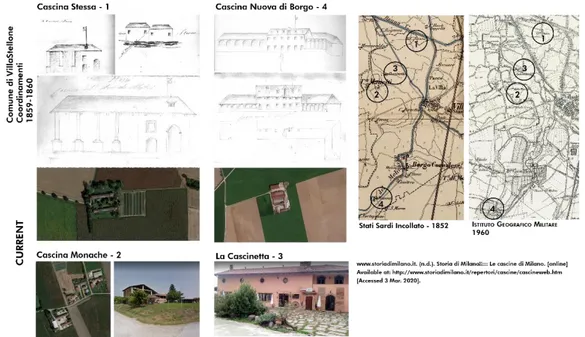
The primary sources which were taken from “Archivo di Stato di Torino”8 used during the
analyses of historical landscape elements of Borgo Cornalese are as listed below; • French Cadastral, Municipality of VillaStellone, 1802-1814
• Sardinian State Map,1852
• Cadastre Rabbini, Municipality of VillaStellone 1859-1860 • Military Geographical Institute, 1880
• Military Geographical Institute, 1968 • Regional Technical Map, 1991
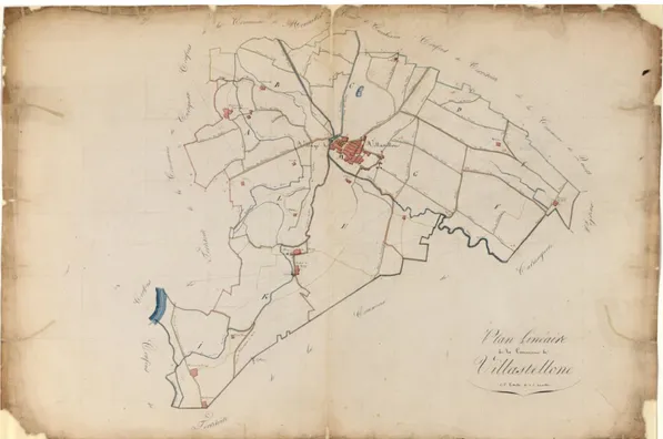
Fig 1: 1802-1814 Plan Linéar de la Commune de Villastellone s. d. s. or. Scala grafica 1/10000 Source: ASTo (The Turin State Archive)
4.2 Brief Information About Borgo Cornalese and Its Historical Background
Borgo Cornalese is a hamlet located in the Piedmont region which is in the north of Italy and the history of this hamlet dates back to A.D 1000. Since the Napoleonic period, Borgo Cornalese is part of the Villastellone municipality. Before feudo was composed by four different buildings, three of which fortified: Fortepasso Malpertusio (today Cascina Nuova), Castello di Borgo and Val di Cosso (today Cascina Valcorso).
Between the 1300s until 18th century, the Costa family, the treasurer of Prince Acaja settled there. By the 1500s, the village transformed into an agricultural settlement with Villa and the mill. “The church of Madonna dei Dolori e dei Santi Barnaba ed Eugenio” was commissioned from Duke Eugenio Laval di Montmorency to the important architect Benedetto Brunati in
8 The Turin State Archive is part of the network of Italian State Archives, peripheral bodies of the MiBACT (Ministry for
Cultural Heritage and Activities and for Tourism), present in each provincial capital city for a total of over 100 locations. (https://archiviodistatotorino.beniculturali.it/contatti/istituto/)
1850. The duke De Montmerency transformed the villa (Villa de Maistre) into a large residence extending the building after 1830 and gifted it to his wife Anne Costance de Maistre.
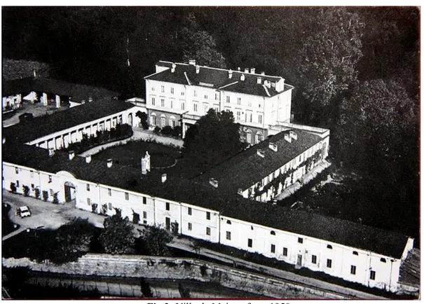
Fig 2: Villa de Maistre from 1950 Source: https://www.borgocornalese.it/
Behind the villa, 16 hectares of the park extends where there were vineyards at the beginning of the 19th century. In this park, there are beeches, oaks, lime trees, poplars, and many other plants.
Fig 3: Villa de Maistre and the park behind the villa Source: Google Maps, 2020
4.3 Heritage Landscape Analyses of Borgo Cornalese
In this part, there are the landscape elements which are categorized and in order to analyse the heritage landscape of the site.
a. Natural and Artificial Hydrographic Network
The analyses of the Po river are focusing on a proportion of the Po Valley which is located in the Torino Metropolitan Area and there is the territory of Carmagnola in the southeast, Carignano in the west, Moncalieri and the city of Turin in the north. This part of the river, today mostly characterized by meanders and large artificial lakes which are results of a mining activity starting in the second half of the last century, detected on cartography for the first time by the IGM (Geographic Military Institute) map of 1968. This kind of intervenes on the river represents a hydraulic risk factor linked to the possible erosion of the narrow embankments that separate lakes from the river course. Apart from these hydraulic risk factors, these artificial lakes are also a reason for the enrichment of the ecosystem in the territory.
Po is a river which is affluent in terms of meanders. Due to the hydrographical characteristics of the river such as the velocity of the water and the flood risk, there was no possibility to use a watermill downriver. Since the middle ages, canals have been used for irrigation and other agricultural activities by locals. Another important economic activity on the river is fishing which has a historical background. The meandering structure of Po River has caused the formation of the water stretches called “lanche” which led to the existence of many different fish species. This is one of the main reasons why fishing activities have been seen in the area for a long time.
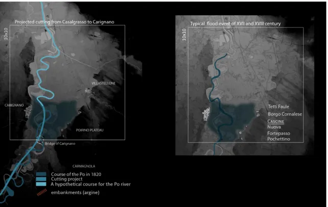
The river has experienced many violent events that caused erosions, floods of vast areas. Historical hydraulic issues of the Po are reflected also in the literature and can be traced back to the XVI century. Especially the area between Casalgrasso and Carignano is subjected to the most changes due to the hydraulic issues. This 12 km long stretch of the water, the riverbed is particularly affected as a result of the natural deviation of the Po and the interferences of local people and administrative bodies in the territory.
On the other hand, this physical condition of the river also influences the administrative borders of the towns. For instance, the borders between Carignano and Carmagnola are in an irregular structure and there is a kind of interpenetration between these borders because of the “islands” of Carignano’s municipality which are falling in the municipal territory of Carmagnola as seen from the figure below.
Fig 4: The administrative borders of Carignano, Carmagnola and VillaStellone Source: Made by the research group of Designing Resilient Heritage Estate Landscapes Atlas
The interventions on the riverbed to control the water flow velocity caused deeper problems by the time. Many of the projects as cutting of the river, deviation, and construction of embankments since the XVIII century has been insufficient to for the idea of the managing the river. In actual fact, these projects carried out in the last three centuries have intensified the flood events and enlarged the proportion of areas affected by the phenomena.
According to the Professor Giacomo Rodolfo9, born in Carignano, since Roman times the
area was affected by flood events which were caused by the attempts to control the river course. These attempts are cited in the literature and on the other hand, the historical official state cartography and technical drawings demonstrate the meandering tendency of the river to follow the natural course, by ignoring human orientations.
9 Città di Carignano. “Città Di CARIGNANO - Sito Internet Istituzionale - Regione Piemonte - Città Metropolitana Di Torino.” Www.comune.Carignano.to.It, www.comune.carignano.to.it/ita/gallery.asp?id_gallery=8.
Fig 5: The projected interventions on Po and the typical flooding event of 17th and 18th centuries
Source: Made by the research group of Designing Resilient Heritage Estate Landscapes Atlas (BDTR 2019 –
DTM ICE 5 2020)
Fig 6: Embankments and flooding event of 1849
Source: Made by the research group of Designing Resilient Heritage Estate Landscapes Atlas (BDTR 2019 –
DTM ICE 5 2020)
As seen from the figure above, there are embankments and cuttings on the riverbed have been made in order to control the velocity of the water and facilitate economic concerns such as transportation and agricultural activities. Besides, the flooding events caused by these interventions can be seen above. The critical point here is that the building structures such as cascine and Borgo Cornalese are located in the higher points of the territory in order to avoid
the destructive results of the floods. The elevation differences are helping to create this environment as seen from the darker parts of the illustrations.
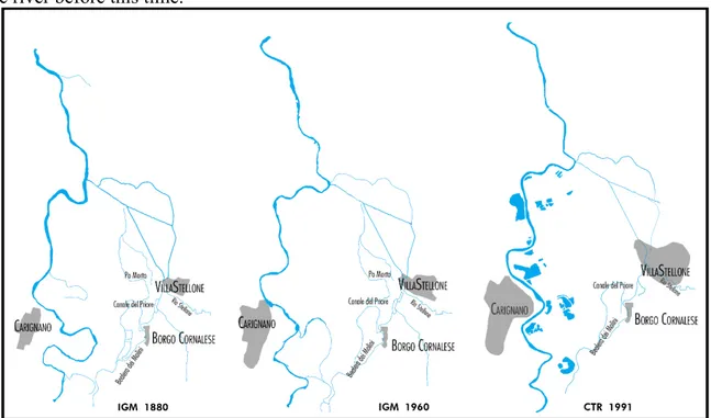
The previous courses of the river can be traced back not only with the historical maps and drawings but also with the photos of the current situation of the territory. The former courses left marks on the landscape with the presence of riparian vegetation and linear woods. However, these traces are not easily identifiable or either trustable. Since the historical cartographic sources date back to the 18th century, it is not correct to comment on the state of the river before this time.
Fig 7: The changes on the river and channels from 1880 until 1991
Source: Made by the research group of Designing Resilient Heritage Estate Landscapes Atlas
Overall, it is seen that the biggest hydrographic change is the lakes formed by mining activities in the territory. However, it is observed that some canals and waterways have disappeared or changed shape with the interventions made through the development process of the site.
b. Road Network and Settlement Structure
From a general point of view, it can be said that the road network and settlements in the region have developed with the idea of both protecting from the destructiveness of the Po river and positioning them in accordance with trade routes. To understand the general structure of the territory, it is also important to carefully read the administrative relationship between the settlements. For instance, even if Borgo Cornalese belongs to Villastellone municipality today, until 1797, Borgo Cornalese was independent agricultural hamlet and it was an important node of this agricultural settlements network. Thus, there was a strong relation with between the hamlet and the cascine around.
Sources show Borgo Cornalese was excluded by the main routes until the half of the XIX century, when the owner the duke Laval Montmorency gave to Borgo Cornalese a new position in the territorial context, starting from the route network. This inclusion of Borgo Cornalese into the road network was completed by the tree-lined boulevard so-called Strada dei Prati
(Lawn’s road) and represents a monumental access of the Laval-Montmorency’s estate with its renovated façade.
Another key point related with the road network and the settlements is the trade activities in the territory. The most remarkable example of these activities is the salt trade which had been going on at Cascina Fortepasso. This farmhouse was called as casetta del sale (little house for the salt) and it was a salt deposit for centuries. To transport the salt from Fortepasso to Turin, Po River was used and Carignano bridge was constructed. Today this bridge is called “Regiona Ponte Po” and it is a fraction of Carignano municipality. In 19th century, it was called as “ponte
di Carignano” and it was connecting Fortepasso to the Port of Carignano. With the
construction of railway and the station in Villastellone, the port turned into a bridge for Villastellone. First it was a wooden bridge but in 1889 it turned into a masonry one. Lastly, after WWII, in 1951, the damaged bridge rebuilt in reinforced concrete and a bearing arch. Today, the fraction of Municipality of Carignano, Regione Ponte Po is located on the same point with 25 habitants and its known for rowing club and sport tourism activities on Po river. Considering the physical conditions of the roads from the cartographic sources, in early 19th century, the road network consisted of earth roads or paths mostly and the primary road in the hierarchy was the tree aligned road connecting Turin to Racconigi and passes from Carignano. Today this road is called “Regional Road 20 OF Colle di Tenda SR 20” which the variant of Carignano and was opened in 1992. Besides, in 19th century, the idea of road structure was mostly connecting the agricultural lands and cascine to each other with the paths. From 20th century, the road hierarchy changed particularly with the construction of highway which is the state highway A6 Torino-Savona and it was opened in 1960 to connects the southern parts of Piedmont with the Liguria Region. Until 1973 the highway did not have double tracks doubling works finished in 2001.
When the date was mid-19th century, the biggest change on the road network was the railway which passes from east of Villastellone. Trofarello-Cavallermaggiore-Savigliano railway was opened in 1848 and the first version of Villastellone station was built in 1860. After WWII, the demolished station was renewed in 1950s.
Fig 8: The changes on the physical condition of the roads in the territory from 1819 to today Source: Made by the research group of Designing Resilient Heritage Estate Landscapes Atlas
Fig 9: The change in the transportation network
Source: Made by the research group of Designing Resilient Heritage Estate Landscapes Atlas (BDTR 2019 –
c. Settlement Configuration Between 19th and 21st Centuries (Villastellone – Borgo Cornalese)
Fig 10: Figure showing the direction in which settlements have grown over time Source: Made by the research group of Designing Resilient Heritage Estate Landscapes Atlas
d. Typical Rural Built Structures from the Study Area
Cascina: A type of traditional rural building of the Po Valley especially in Lombardy and
Piedmont regions for agricultural uses. These buildings had been used in the Po Valley at least since the 16th century, even though they became common in the 18th and 19th centuries. In particular, during the Napoleonic era, several religious buildings were transformed into cascine.
Fig 11: Typical Farmhouses from 19th century which are still exist on the territory
e. Fragmentation on the Territory Through Centuries
Fig 12: The changes on the fragmentation of agricultural parcels and water courses since 19th century due to urban development and industrial activities
Source: Made by the research group of Designing Resilient Heritage Estate Landscapes Atlas (Ecology group)
The figure above shows four different period of the territory in terms of agricultural parcels and how they changed by the centuries. It can be seen how the river lost its meanders and the wooden areas began to be deformed in order to have more space for intensive and extensive agriculture. Besides, with the construction of the highway mentioned above, the ecological continuity of Carmagnolese plain was interrupted.
Below, there is the figure shows the processes the soil of territory. Especially with the industrial constructions and heavy infrastructures as highway passing through the plain, the ecological corridor had begun to disappear, the soil had become more fragmented and pressure on the soil had increased by the time.
Fig 13: Homogenization process in the territory
Source: Made by the research group of Designing Resilient Heritage Estate Landscapes Atlas (Ecology group)
With the increasing industrial and intensive agricultural activities, the general texture of the area has changed, and the resilience of the soil has decreased with the added urban sprawl pressure. At the end of the 80's the land was filled with artificial ponds, with the traces of the quarries mentioned above. In addition to afforestation works, these ponds, which were created by mines from the 80's, have now been strengthened to create new habitats and restore the natural richness of the area and transformed into natural areas used for leisure activities.
Fig 14: The changes on the land reasoned by urban pressure, quarries and transportation infrastructure & An
example for the last situation of the man-made ponds (former quarry) today
Source: Made by the research group of Designing Resilient Heritage Estate Landscapes Atlas (Ecology group)
f. Visual Perception and Perspective Features of Borgo Cornalese
Borgo Cornalese have several landscape identities which gives a character to the territory. First of all, the Po river has a landscape identity created in the region with its dominant character, and this deeply affects all ecological, historical and other identities of the landscape. Then, the rural and geomorphological characteristics of the region are also very influential on its landscape identity. Especially the presence of the Alpine Mountains in the background creates a very striking effect. Finally, the historical landscape character, which is causally related to this research paper, is deeply affected by the other identities of the territory mentioned above.
Fig 15: The scenic characteristics of the territory
Source: Made by the research group of Designing Resilient Heritage Estate Landscapes Atlas (Scenery
Fig 16: Scenic characteristics of Borgo Cornalese
Source: Made by the research group of Designing Resilient Heritage Estate Landscapes Atlas (Scenery Group)
g. Identity Assets of Borgo Cornalese
Fig 17: Identity assets of Borgo Cornalese
Source: Made by the research group of Designing Resilient Heritage Estate Landscapes Atlas (Scenery Group)
Above, there is the figure created by the Scenery group of Workshop underlined the assets which considered function as representing local identity of Borgo Cornalese.
4.4 Conclusion
At the end of this workshop, the landscape character of the area was analyzed in certain categories. Although the main categories are history, environment & risk, scenery & perception, land uses and activities, these categories are divided into subheadings and assessed. The visuals which were obtained as a result of this analysis and the selected interpretative categories are given above. Even though the main purpose is to determine the necessary steps to increase the resilience of the site, the required analyses for the management of the site were also taken into consideration. In this case, a landscape characterization study experienced from beginning to end was obtained and the experience gained from this study was associated with the compared operative frameworks in the second part of the study, and as a result, a categories proposal was proposed and discussed.
Although the scales of the samples studied in the second part of the research were quite different from the scales studied during the workshop, the analytical keys determined allowed a meaningful heritage landscape assessment on this scale.
Part II – Aristocratic Estate Case Study Analyses on Historical Landscape
Management and Interpretation
5. INTERNATIONAL DOCUMENTS AND REGULATIONS ON
CULTURAL LANDSCAPE
There are Landscape plans prepared by countries in accordance with their own methodologies and approaches, but there are international documents and regulations that guide or in other words, bind these plans as The UNESCO Convention, Cultural and Natural Heritage, The European Landscape Convention of the Council of Europe and the EU Territorial Strategy and Agenda. The recognition of the arguments on the cultural landscape and its preservation was adopted with the Charter of Athens (League of Nations, 1931). Then it continues with the Venice Charter on the conservation and restoration of monuments and sites (ICOMOS, 1964) and so on. Below, the main two of these international documents are explained briefly regarding their impact on national cultural landscape plans and other management tools of the countries. Since the above abstract information is given about the European Convention, it is not mentioned separately in this section. However, the convention is mentioned in the parts required for each case study.
5.1 Convention Concerning the Protection of the World Cultural and Natural Heritage, UNESCO (1972)
The primary aim and mission of this convention are to identify and protect the world's natural and cultural heritage considered to be of Outstanding Universal Value. It is an initiative of UNESCO itself and the IUCN. It has a visionary idea – that some places are so important that their protection is not only the responsibility of a single nation but is also the duty of the international community as a whole; and not only for this generation but for all those to come. In this convention, the cultural landscape assets are divided into 3 categories as monuments, complexes, and places (sites).
Article 1
For the purposes of this Convention, the following shall be considered as "cultural heritage":
monuments: architectural works, works of monumental sculpture and painting, elements
or structures of an archaeological nature, inscriptions, cave dwellings and combinations of features, which are of outstanding universal value from the point of view of history, art or science;
groups of buildings: groups of separate or connected buildings which, because of their
architecture, their homogeneity, or their place in the landscape, are of outstanding universal value from the point of view of history, art or science;
sites: works of man or the combined works of nature and man, and areas including
archaeological sites which are of outstanding universal value from the historical, aesthetic, ethnological or anthropological point of view.
5.2 European Spatial Development Perspective, European Union
It is a document approved by the Informal Council of Ministers of Spatial Planning of the European Commission in Potsdam in 1999. The aim is to achieve a balanced and sustainable spatial development in Europe and provide an integrated, multi-sectoral and indicative strategy. Fundamentally, it is a result of the process that was being carried out by the Council of Europe and that entailed the expansion of landscape spaces to more elements.
6. HISTORICAL LANDSCAPE STUDIES
As a branch of the landscape studies, historical landscape analyses, identification and assessment are also considerably important for current planning activities and development policies. Although the assessment indicators can differ from country to country, the importance of "historical landscape elements" mentioned below is common for these studies.
First of all, these elements represent the historical development of that area which involves the cultural, economic, and natural transformation made by society, and this transformation also includes technological developments by the time. Moreover, historical landscape elements contribute to their peculiarities and character of landscapes that make them unique. Sometimes this individuality also comes from special species of plants and animals, which the landscape can be the last sanctuary. Lastly, these particular landscape elements are inspiring and educating features as extracurricular learning places (Bastian et al, 2013).
In the European context of landscape studies, ELC and ESDP10 could be seen the main
sources for the regulation which bring together the administrations (local & national) and the professionals. Apart from ELC, which explained above, ESPD includes cultural landscapes in the EU’s cultural heritage, recognizes them as an economic factor of growing importance for sustainable development, which is an important binding factor for European countries, and
establishes a series of political and regulatory options for the creative management of cultural landscapes. 11 In accordance with this purpose, the Principles for Sustainable Territorial
Development of the European Continent of the Council of Europe (Hannover, 2000) also recognise cultural landscapes as a significant part of the European heritage, incorporate the objectives of the ELC and add the consideration of the landscape to the international programmes and to cross-border, transnational and interregional cooperation in matters of landscape (National Cultural Heritage Plans Catalogue, the Ministry of Culture and Sport of Spain).
6.1 An Overview of the Assessment of Historical Landscape Elements
Since HLE and traditional landscape elements disappear rapidly and are under threat, identification of these elements and ensuring their survival are of immense importance. Therefore, a detailed study should be conducted on the status of the cultural landscape and the stock of the historical elements. For the first step of these studies, it is necessary to identify historical elements, in other words, to distinguish traditional elements. According to Nowak and Schulz (2004), essential features of historical landscapes are; a convenient state of conservation, only minor changes in the landscape structure, the scenery since 1950, frequency of landscape formations of the past and the recent landscape features only integrated with the historical elements. Contrary to this situation, the features that cause landscapes to be excluded and lose their historical importance are as follows; the essential changes of the landscape character and the scenery of the whole area, land consolidation, dense urbanisation, loss of historical elements. For Schmidt, whose academic studies are frequently used in landscape, the criteria for HLE assessment can be; rareness, the state of preservation, age, regional importance, experience value.
6.2 Historical Landscape Indicators
Indicators, that form the main idea of this study, refer to a highly diversified concept of historical landscape in the evaluation processes. To set an example, the scale of the work is important to determine the logic of indicators. The greater the scale; policy-oriented indicators are involved for economic and social comparison. The reduced the scale; the more suitable the indicators are for directly monitoring the physical transformations of the territory (Volpiano, 2011).
Indicators concerning historical landscape features started to be mentioned in the documents with the sustainability studies of the United Nations towards the end of the 1990s. The document drawn up by the Global Urban Observatory of the United Nations12 (UNCHS 1997)
indicates that “The purpose of the Urban Indicators Programme is to build national and local capacity to collect and use policy-oriented indicators as part of a strategy for the development of sustainable human settlements” (Volpiano, 2011). Again, in 1990s, OECD developed a set of indicators including also the historical-cultural aspects briefly “…Thus, degradation of landscape entails both a loss of naturalness and historic cultural values. So far, no internationally agreed definition of landscape exists, and no attempt has been made to develop landscape indicators in this report” (OECD 1993). Yet another, Heritage Counts, the annual
11 Political options for cultural landscapes: (1) Conservation and creative development of the cultural landscapes that have a
particular cultural, historical, aesthetic and ecological significance. (2) Enhancement of the cultural landscapes as part of the integrated territorial development strategies. (3) Improvement of the coordination of measures affecting landscapes.
survey of English Heritage, propounds a set of indicators which in 2009 they have highlighted the key changes or findings for 2008/09 as compared to previous years were divided in 3 main categories as; Understanding the Assets (Data on the extent of historic environment assets),
Caring & Sharing (Data on the condition of assets and resources, including funding available
to manage them), Using & Benefitting (Data on the social, economic and environmental benefits derived from active use of the historic environment (Heritage Counts, 2009).
7. REVIEWS OF CASE STUDIES
In the following part, the selected case studies are examined according to documentation prepared by their own countries which are all examples from Europe. In this way, the application of the European Landscape Convention and the approach of each country could be compared. The case studies are Royal Residences from Italy, France, and Spain which are all a node from different Royal Residence networks. First, the approach to the territory which includes the network and then to the single residence is studied. Although the size differences between residences are being aware of, since they are part of certain residential networks, the important characteristic in this study is not their scale.
7.1 Italian Case Study (Savoy Residences – Veneria Reale)
European Landscape Convention is a jointly accepted document but more importantly, it is common goals and policies shared by European countries for their future. Inherently, Italy is one of these countries that conforms to this convention and even shapes her landscape studies and applications accordingly.
The origin of landscape issues and studies in Italy is mostly based on the protection of cultural, historical, natural, and landscape phenomena from the laws of 1939. Basically, landscape analyses are the studies for assessment of landscapes and adjustment of landscape plans which state and regional authorities are responsible for (Voghera, 2011). The Italian approach can be named “attempts to integrate protection and development” which bears a striking similarity with French and Spanish approaches.
The practices of the landscape assessment of Piedmont and the categories of the examined components of the heritage landscape can be analyzed and compared with the other European examples in this research paper through the detailed studies named “Drafting of the
Management Plan” made by DIST - Politecnico di Torino (assigned by the Regional Directorate for the cultural and landscape heritage of Piedmont (2012-2014)) and with the regional plan of Piedmont (PPR).
7.1.1 Regional Landscape Plan (PPR) and the Evolution of Historical Landscape Reading Methodology
The Regional Landscape plan is an instrument for the protection and promotion of the Piedmontese landscape to regulate its transformations and to support sustainable development in the territory (Governo Italiano - Regione Piemonte) . The last regional plan was adopted in 2015 and approved in 2017.
The approved PPR documents are available in PDF format and the relative cartography can also be consulted through a WebGis viewing service (webgis.arpa.piemonte.it) via interactive
maps. The data of the Tables can be downloaded in shapefile format from the Piedmont Geoportal, Catalog section. There is also the booklet that explains the path, the strategies, and objectives of the PPR.
Firstly, the PPR is kind of a tool for adaptation of the principles and policies derived from the European Landscape Convention and the Code of Cultural Heritage and Landscape. The structure of the Plan consists of the recognition of 76 landscape areas into which the regional territory is divided, in the definition of objectives for landscape quality and, at a regulatory level, in the definition of guidelines, directives, and prescriptions for other planning tools.
Secondly, the PPR constitutes an act of general regional planning based on the principles of sustainable development, conscious use of the territory, less consumption of the agronatural soil, protection of the landscape characteristics, and promotion of values landscape coherently inserted in the single environmental contexts. The purposes of the PPR and the Regional Territorial Plan (PTR) are therefore structured according to five main strategies and the first strategy includes the historical heritage landscape integration and protection. From these five main strategies derives 26 objectives again valid for both PPR and PTR. The particular purposes and strategies for landscape-environmental aspects are instead largely different from the territorial ones concerning the specific themes and diversified interests.
In the “Atlas of historical Piedmontese landscapes” in 2007, which was created by Vero Comoli, Mauro Volpiano, Claudia Cassatella, et al., the main methodological result was the proposal to overcome a conception of historical surveys on the landscape. Beyond the metaphor, it was then tried to make this approach operational by proposing the recognition of landscapes determined mainly by some specific and characterizing historical-territorial assets, then geo-referenced with GIS systems. The idea was to investigate not the “castle” but the settlement and road system around the castle, or not only the “farmhouses” but also the productive landscape of the plains with the irrigation systems, the built structures, the paths and so on (Volpiano, M., Il Piano Paesaggistico Del Piemonte, 2018 page 69). These studies let the historical values, for example disused roads, to be a potential for reuse or to revalue the territory today. This atlas and the historical studies of the first PTR (1997) are the turning points of today's landscape studies in which the landscape plan and historical cultural landscape elements are included in each other. For example, until a few years ago, large infrastructures of energy, such as dams and power plants, or the infrastructures for alpine tourism, or the 19th-20th century high-ground fortifications and mining sites were not included in the historical-cultural landscape assessments and the planning process. This operation was carried out in the awareness that an urban planning tool is always "temporary” and new technicians could consider some assets to be "outdated" and will focus on others.
There is another innovative side of the PPR that the studies support the historical part of the plan assessed not only the tangible but also the intangible values of the territory which as the perceived landscape with its components historically consolidated in terms of axiality, perspective system, historical viewpoints etc. These are important components of the landscape which describe it and give it an identity.
Lastly, the implementation processes of the plans can be called open process due to the inclusion of the local actors. The idea is that the categories of the analyses are reflected in general guidelines and regulations but local actors must become aware of the choices made by the planner, become aware of the evaluation and selection criteria adopted in the PPR, and then
proceed - according to their own rigorous scientific tools - to develop or not the hypotheses posed by the Plan, deepening them, specifying them or integrating them with new and more sophisticated analyses, which respond to requests posed by specific socio-economic contexts. To avoid misunderstandings and top down decisions, each community is be called to reflect deeply on its own memory and desire for the future of their territory (Volpiano, M., Il Piano Paesaggistico Del Piemonte, 2018 page 72).
Fig 18: The aims of the Piedmont Landscape Plan
Source: Made by the Author based on “The Regional Landscape Plan Illustrative Booklet”
7.1.2 Historical-Cultural Landscape Components Interpreted on Landscape Plan of Piemonte
As stated above, the general frames for the investigations of the landscape elements have already been defined by the laws for all the regions in a generic way. For historical and cultural landscape which is included in the “Tavolo P4”, the components are as listed below (Direzione Ambiente Governo e Tutela - Regione Piemonte):
• Historical viability and railway heritage (Act 22) • Archeological interest areas (Act 23)
• Historical centers (Act 24)
• Historical rural heritage areas (Act 25)
• Villages, gardens, parks and areas of leisure and tourism (Act 26) • Industrial production and energy plants of historical interest (Act 27) • Poles of religiosity (Act 28)
• Fortification systems (Act 29)
From the studies of Mauro Volpiano and Andrea Longhi from The Landscape Plan of Piedmont Region - December 2018, a table which shows the “Components of historical-cultural interest governed by the laws” and “List of Historical-Territorial Systems defined in historical analyses on PPR” was taken to investigate the indicators for Italian case study.
Fig 19: Analysed Components of Historical Cultural Landscape Source: Volpiano, Mauro. Il Piano Paesaggistico Del Piemonte, Dec. 2018.
a. The Interactive 2017 Regional Landscape Plan
The official website of Arpa13 Piemonte, the PPR is served online with the interactive
Gis-based maps which are able to be downloaded. The PPR is divided into 6 categories. After the introduction part which explains the other categories and how to utilize the online PPR, there is P2 – Landscape Assets, P3 – Landscape Units, P4 – Landscape Components, P5 - Sites included in the UNESCO World Heritage List, SIC and SPA, and lastly P6 – Macro Areas of Landscape.
Among all these categories, P4 is the one where is the heritage and cultural landscape assets are identified.
Fig 20: Tavola P4 – Landscape components of the study case territory Source: Made by the author based on the materials from WebGIS ARPA
Above, there is the map created by the interactive PPR – Table P4. In this part of PPR, the components are divided into four main categories as; naturalistic-environmental,
historical-13 The Regional Agency for the Protection of the Environment
cultural, perceptive-identity and morphological-settlement which all these categories are based on articles of the plan mentioned above. Landscape components are shown in 1:50.000 scale.
Later on, at P2 – Landscape Assets category which the scale is 1:100.000, the region is divided into 6 sub-territories in according to their assets. On this map, Venaria Reale and the Park of La Mandria are illustrated as “public interest of the Castle and the areas of the Royal Gardens”.
Fig 21: P2- Landscape Assets
Source:Made by the author based on the materials from WebGIS ARPA
On P3, Piedmont is divided into 76 landscape areas. These 76 landscape areas, in order to represent the map of the identity landscapes of Piedmont, were aggregated into 12 macro-areas, homogeneous both with respect to geographical characteristics and with respect to perceptual components, identified in Table P6. According to this categorization, Venaria Reale is the 36th
unit and it is “urban relevant altered”. Even if its not directly considered in heritage landscape assessment, this categorization is also shown below to clear the landscape features of the territory according to planning practices of the region.
Venaria Reale & La Mandria
Fig 22: P3 Landscape Units
Source: Made by the author based on the materials from WebGIS ARPA
Fig 23: The scheme showing the cultural heritage systems of Piedmont Region