P
ietroP
aoloPieraNtoNi
(*), e
rNestoCeNtaMore
(**)& M
arioCosta
(***) (*)Università di Camerino - Scuola di Scienze e Tecnologie - Sezione Geologia - Via Gentile III da Varano - 62032 Camerino, Italy(**)Via Muzio Clementi, 58 - 00193 Rome, Italy (***)Via P. Selvelli, 6 - 61032 Fano, Italy Corresponding author: [email protected]
GEOLOGICAL AND SEISMOLOGIC DATA REVIEW OF
THE 2009 L’AQUILA SEISMIC SEQUENCE (CENTRAL APENNINES, ITALY):
DEEP-SEATED SEISMOGENIC STRUCTURES AND SEISMIC HAZARD
EXTENDED ABSTRACT
Il 6 Aprile 2009 un terremoto di MW=6.1 ha interessato la media-alta valle dell’Aterno, danneggiando L’Aquila e dintorni. Questo settore si ubica in una stretta fascia in direzione NNW-NW lungo la zona assiale dell’Appennino Centrale, caratterizzata da frequenti crisi sismiche anche di elevata intensità. Sia prima che dopo l’evento di Aprile 2009, sono stati eseguiti numerosi studi in questo settore con lo scopo di identificare le faglie quaternarie e le sorgenti sismiche. La grandissima maggioranza degli autori, basandosi principalmente su elaborazioni e dati prevalentemente sismologici, ritiene che la sequenza sismica dell’Aquila 2009 sia stata provocata dall’attivazione delle faglie di Paganica e di Mt. Gorzano, faglie estensionali quaternarie di modesta estensione lineare, ad andamento NW-SE e immergenti a SW.
In questo lavoro è stato utilizzato un approccio differente: prima di tutto si è cercato di ricostruire un quadro omogeneo e preciso dell’assetto strutturale dell’area per individuare e caratterizzare le principali strutture quaternarie, integrando i dati di superficie con quelli del sottosuolo, ricavati dall’interpretazione delle linee sismiche a riflessione disponibili. Successivamente, è stata ricostruita, utilizzando i dati del Bollettino Sismico dell’INGV, la distribuzione spazio-temporale della sequenza sismica. La principale (per sviluppo in superficie e in profondità) struttura quaternaria dell’area è risultata la Celano-Cittareale (CCFS); essa è costituita da un complesso sistema di faglie orientato circa NW/NNW-SE/SSE, per lo più NE-immergenti; è stata identificata dalla Piana del Fucino fino oltre Cittareale, ma prosegue ancora più a sud e più a nord. CCFS si radica in profondità nella crosta con piani ad alto angolo, NE-immergenti. Nella parte più superficiale (fino a circa 10 km di profondità), CCFS è costituita strutture a fiore, talora positive e talora negative, con faglie SW e NE-immergenti; in profondità è caratterizzata da piani ad alto angolo prevalentemente NE-immergenti. Durante il Quaternario è stata attiva talora con cinematica transtensiva sinistra e talora puramente distensiva; la componente transtensiva è stata comunque predominante. Le altre numerose faglie quaternarie, per lo più SW-immergenti, presenti nell’area hanno uno sviluppo molto più limitato rispetto a CCFS sia in superficie che in profondità. I piani delle faglie di Paganica (sintetica del principale sistema di faglie di Barisciano-BFS) e Mt. Gorzano sono più superficiali e si interrompono contro CCFS a circa 9/10 km di profondità. CCFS è interrotta localmente da sistemi di faglie trasversali/oblique (NE-SW/NNE-SSW) ad attività quaternaria. La ricostruzione spazio-temporale della sequenza sismica indica che essa si è verificata per step successivi a partire da sud verso nord, formando tre distinti clusters di terremoti aftershocks. I tre clusters sono ciascuno confinati: a sud e a nord da sistemi di faglie trasversali /oblique antiappenniniche, a ovest da CCFS e a est da BFS e GF. Il primo cluster a formarsi e anche il principale come numero, Magnitudo, main shock e profondità dei terremoti è quello meridionale, confinato dalle strutture trasversali di Rocca di Mezzo a sud e S. Vittorino a nord. Gli altri due più settentrionali hanno iniziato a formarsi rispettivamente a distanza di diverse ore e di alcuni mesi dal main shock. Gli epicentri dei foreshocks, sviluppatesi da Ottobre 2008 fino al main shock, formano un addensamento che si ubica unicamente nella parte centro-occidentale dell’area del cluster meridionale.
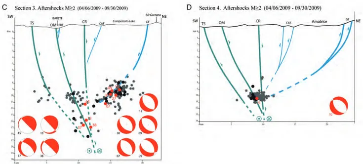
Sono stati eseguiti quattro profili strutturali-sismologici con andamento circa NE-SW, ortogonali rispetto alle strutture quaternarie. Due nell’ambito del cluster meridionale e gli altri due nell’ambito degli altri due cluster. I due più meridionali evidenziano che gli ipocentri degli aftershocks si concentrano lungo i piani di CCFS e BFS; quelli in corrispondenza di CCFS raggiungono anche profondità notevoli (> 19/20 km), gli altri si attestano fino ad un massimo di circa 10 km di profondità. Meccanismi focali talora estensionali e talora transtensivi sono presenti lungo CCFS fino a circa 10 km di profondità; al sotto sono transtensivi. L’analisi della distribuzione spazio-temporale degli ipocentri evidenzia che i terremoti ricadenti sui piani di BFS sono avvenuti un po’ più tardi rispetto a quelli presenti su CCFS. La proiezione in profondità dei foreshocks e del main shock evidenzia che questi ricadono sui piani di CCFS, senza coinvolgimento di BFS. Gli altri due profili mostrano una situazione analoga, l’unica differenza sta nel fatto che la faglia antitetica di CCFS è in questo caso GF. In base a quanto sopra risulta che la sequenza sismica dell’Aquila sia stata causata dalla progressiva attivazione di tre segmenti di CCFS mentre BFS/ GF si sono attivate successivamente per accomodamento. Il primo ad attivarsi è stato un tratto di circa 10/12 km del segmento meridionale; questo ha causato il main shock (MW=6.1) e il maggiore (MW=5.4) aftershock.
ABSTRACT
This study identified and characterized an important and complex Quaternary structure, the Celano-Cittareale Fault System (CCFS), crossing NNW/SSE-NW/SE through the entire area of the L’Aquila 2009 seismic sequence. The CCFS, which develops from the Fucino Plain and further north to Cittareale, is locally segmented by NE-SW/NNE-SSW transversal/oblique faults. It is a regional flower structure, deeply rooted in the crust, mainly NE-dipping and overall high-angle, characterized during the Quaternary by left transtensional kinematics. Based on the data acquired from the literature and on our reconstructions, the CCFS was the main seismogenic structure responsible for the 2009 L’Aquila seismic sequence and for other important seismic sequences, in particular those of 1703 and 1915. According to our view, the SW-dipping Paganica Fault (PGF, a splay of the main Barisciano Fault System BFS) and the Mt. Gorzano Fault (GF), considered by previous authors to be the only ones responsible for the 2009 L’Aquila seismic sequence, were instead local and more superficial faults, antithetical to the CCFS, activated at different times by accommodation.
During the 2009 seismic sequence, three CCFS segments, bounded by four transversal/oblique fault-systems, were active stepwise from the south to the north, producing three clusters of earthquakes that differed in energy and number of events. The activation of the CCFS southern segment caused the largest number of earthquakes, including the foreshocks, the main shock (MW=6.1) and earthquakes deeper than 20 km. The earthquakes of this cluster were characterized by left transtensional and extensional kinematics. The activation of the other two CCFS segments and of the BFS and GF produced earthquakes of lower magnitude that also were shallower and characterized by predominantly extensional kinematics.
The main transversal faults played different roles: the RMF (Rocca di Mezzo Fault), MF (Marana Fault) and TFS (Torrita Fault System) passively confined the three clusters of the 2009 L’Aquila seismic sequence to the south and to the north, respectively; instead, the intermediate SFS (San Vittorino Fault System) first confined the southern cluster to the north at the onset seismic of the sequence and subsequently, by activating as a right transfer fault, it became itself seismogenic.
Keywords: 2009 L’Aquila Earthquake, active fault system, seismogenic
structures, Central Apennines, seismic hazard
INTRODUCTION
On April 6th, 2009 a MW=6.1 earthquake occurred in the
Upper-Middle Aterno Valley, strongly damaging the town of L’Aquila and its surroundings. This sector is located in a narrow NNW-NW striking seismogenic belt of the axial Central Apennine chain (Fig. 1), characterized both historically and recently by high seismicity.
Even before the April 2009 event, numerous studies had been conducted on the Central Apennine structural framework and its recent active tectonics, to identify the active faults and the seismogenic sources (Bosi & BertiNi, 1970; Bosi, 1975;
PaNtosti et alii, 1996; BaChetti et alii, 1990; BagNaia et alii,
1992; BertiNi & Bosi, 1993; BluMetti et alii, 1993; BluMetti,
1995; CalaMita & Pizzi, 1994; laveCChia et alii, 1994; 2002;
CaCCiuNi et alii, 1995; D’aDDezio et alii, 1995; salvi & NarDi,
1995; CalaMita et alii,1997; Cello et alii, 1997, 1998; FrePoli &
aMato, 1997; vezzaNi & ghisetti, 1998; galaDiNi, 1999; BarChi
et alii, 2000; galaDiNi et alii, 2000; 2003a; 2003b; galli et alii,
2008; galaDiNi & galli, 2000; 2003; ITHACA WorkiNg grouP,
2000; MoreWooD & roBerts, 2000; toNDi, 2000; galaDiNi &
MessiNa, 2001; valeNsise & PaNtosti, 2001; Moro et alii, 2002;
PaCe et alii, 2002; roBerts et alii, 2004; salvi et alii,2003;
BoNCio et alii, 2004a; 2004b; CiNti et alii, 2004, 2009, 2011;
roBerts & MiChetti, 2004; WorkiNg grouP CPTI, 2004; APAT,
2006a; 2006b; 2006c; 2006d; tertulliaNi et alii, 2006; Bagh et
alii, 2007; CeNNi et alii, 2008; Pizzi & galaDiNi, 2009).
Generally a great part of these authors, using high resolution earthquake distribution, reconstruct the fault-zone geometry of the activated faults, mainly NW-SE trending / SW dipping. Other authors (DesChaMPs et alii, 1984, 2000; salvi & NarDi,
1995; Cello et alii, 1997, 1998; toNDi, 2000), have recognized,
studied and called attention to other important active structures with remarkable seismogenic potential in the Central-Northern Apennines: these are NNW-SSE striking structures belonging to a complex Central Apennines Fault System (CAFS, sensu Cello
et alii, 1997; 1998). According to these authors, they are a surface
expression of a regional deep-seated left strike-slip SW-dipping system with high seismological potential.
Following the 2009 L’Aquila earthquake, a great number of studies were performed, in particular:
• Geological/structural and geophysical research: elter et alii,
2009, 2011, 2012; FaraBolliNi et alii, 2009; galaDiNi et alii,
2012; kraus et alii, 2009; MaNtovaNi et alii, 2009, 2010;
MessiNa et alii, 2009a, 2009b, 2010a, 2010b), 2011;viti et
alii, 2009; BoNCio et alii, 2009, 2010, 2011; galli et alii,
2010, 2011, 2012; MariuCCi et alii, 2010; visiNi et alii, 2010;
BalasCo et alii, 2011; Di steFaNo et alii, 2011; FiNetti, 2011;
gioColi et alii, 2011; iMProta et alii, 2012; FerrariNi et alii,
2012; laveCChia et alii, 2012, 2017; roBerts et alii, 2010;
Bigi et alii, 2013;
• Studies on distribution seismicity / hypocentral location:
aMoruso & CresCeNtiNi, 2009, 2010, 2012; ChiaraBBa et
alii, 2009, 2010; ChiaraluCe et alii, 2009, 2011a, 2011b;
ChiaraluCe, 2010, 2012; CiaCCio et alii, 2010; PiNo & Di
luCCio, 2009; sileo et alii, 2009; tertulliaNi et alii, 2009;
valoroso et alii, 2009; luCeNte et alii, 2010; PoNDrelli et
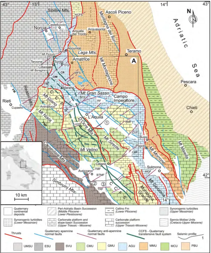
Fig. 1 - Simplified tectonic map of the Central Apennine with location of the study area (key box A). 1 - Trace of the seismic profile IT 89-01 and geological cross-section; 2, 3 - Traces of the seismic profiles 1-80-AZ-03 and 1-82-AZ-05.
UMSU, Umbria-Marche-Sabina Unit; ESU, Eastern Sabina Unit; SMU, Simbruini Mountain Unit; SVU, Salto Valley Unit; CMU, Cicolano - Western Marsica Unit; GMU, Mt. Giano - Montagna Grande Unit; AGU, Accumoli - Mt. Genzana Unit; MMU, Montagna dei Fiori - Montagna del Morrone Unit; MCU, Maiella – Cellino Unit, and the PBU, Periadriatic Basin Unit
Fig. 2 - Simplified structural map of study area.
Quaternary left transtensive Fault System (green): CCFS, Celano-Cittareale (TS, Tornimparte-Scoppito branch; OM, Ovindoli-Marana branch; CR, Cittareale-Rocca di Cambio branch).
Quaternary anti-apennine structures (violet): TFS, Torrita Fault System; MFS, Marana Fault system; VF, Vomano Fault; SFS, S. Vittorino Fault System; RF, Roio-Assergi Fault; RMF, Rocca di Mezzo Fault; CVF, Civitaretenga Fault; CBF, Celano-Bussi Fault.
Quaternary normal faults (blue): GF, Mt. Gorzano Fault; CAF, Capitignano Fault; PBF, Pizzoli - Barete (or Mt. Marine) Fault; SFF, Mt. S. Franco Fault; ARF, Arischia Fault; AF, Assergi Fault; STF, Mt. Stabiata Fault; COF, Collebrincioni Fault; MF, Macchione Fault; PEF, Mt. Pettino Fault; CIFS, Campo Imperatore Fault System; SCF, Mt. Scindarella Fault; FAF, Cima Faiete Fault; RUFS, Mt. Ruzza Fault System; SSS, S. Stefano di Ses-sanio Fault; BFS, Barisciano Fault System; PGF, Paganica Fault; PPF, Poggio Picenze Fault; PAF, Prata d’Ansidonia Fault; BAF, Bazzano Fault; FOF, Fossa Fault; SDFS, S. Demetrio dè Vestini Fault; FNS, Fontecchio Fault System; VEF, Velino Fault.
Miocene-Pliocene, Thrust (red).
SL IT 89-01: trace of the seismic profile and geological cross-section. 1, 2, 3 and 4 structural-seismological interpretative cross-sections
luCCio & PiNo, 2011; herMaNN et alii, 2011; Margheriti et
alii, 2011; vaNNoli et alii, 2012; CalDeroNi et alii, 2013;
• Elaborations of GPS, RADAR and INSAR data: aNtoNioli
et alii, 2009; aNziDei et alii, 2009; atzori et alii, 2009;
avalloNe et alii, 2009, 2011, 2013; Cirella et alii, 2009; De
Natale et alii, 2011; serPelloNi et alii, 2010, 2012; Walters
et alii, 2009; CaPorali et alii, 2010; CeNNi et alii, 2012;
CheloNi et alii, 2010; DisPerati et alii, 2010; guerrieri et
alii, 2010; PaPaNikolaou et alii, 2010; roBerts et alii, 2010;
Moro et alii, 2010 e 2013; Dalla via et alii, 2012; gori et
alii, 2012; tiNti et alii, 2012;
• Research on coseismic surface faulting data: EMERGEO WORKING GROUP, 2009, 2010; FalCuCCi et alii, 2009;
galli et alii, 2009; BoNCio et alii, 2010; Di BuCCi et alii,
2011; vittori et alii, 2011;
• Studies on fluid and ground motion: akiNCi & MalagNiNi,
2009; akiNCi et alii, 2010; aMeri et alii, 2009; italiaNo et
alii, 2009; PaCor et alii, 2009; ÇeleBi et alii, 2010; Di luCCio
et alii, 2010; ChioDiNi et alii, 2011; zaMBoNelli et alii, 2011;
BoNFaNti et alii, 2012; Pastori et alii, 2012.
Many authors hold that the 2009 L’Aquila seismic sequence was induced by the activation of some NW-SE striking Quaternary extensional en-echelon faults, mainly SW-dipping, in particular, the Paganica (Aquila Fault, sensu valoroso et alii, 2013) and the
Mt. Gorzano Faults (PGF and GF). Several debates concerned the relationships between the fault geometries (length, down-dip, depth, width), slip-rates, recurrence time, long-term or short-time kinematics and their role in the seismic hazard, and the thickness of the seismogenic layer. By contrast, some of these authors
(ChiaraluCe et alii, 2011a, b; valoroso et alii, 2013), showed
that a part of the 2009 L’Aquila seismic sequence was located outside the Paganica Fault plane and was disposed along a deeper NE-dipping plane that they regarded as antithetic to the Paganica Fault (ChiaraluCe et alii, 2011a; 2011b; valoroso et alii, 2013).
Furthermore, laveCChia et alii (2012) believe that this seismicity
is related to an indeterminate and yet-to-be located low-angle, NE-dipping “hidden Mts. D’Ocre source”.
The present work tries to recognize, through a different approach, the seismogenic source of the 2009 L’Aquila seismic sequence, on the ground of many data from : a) the vast literature; b) the numerous geological, structural, and morphotectonic data acquired during detailed mapping of the Domains of Lazio-Marche-Abruzzi (CARG Project: APAT 2006a; 2006b; 2006c; 2006d; ISPRA, 2010; MURST, CNR, COFIN Programs; ENI Task Force Maiella; and CEE: Marche Sud Project); c) our identification and definition of the deep structure geometry through interpretation of some available seismic profiles (in particular IT-89-01, 1-82-AZ-05, 1-80-AZ-03, VIDEPI Project); d) our identification and definition of the space-time evolution and kinematics of part of the 2009 L’Aquila seismic sequence (1/10/2008-30/09/2009,
including the 1/10/2008-5/04/2009 foreshocks (PoNDrelli et
alii, 2010) and the 6/04/2009-30/09/2009 aftershocks, Database
ISIDe/BollettiNo sisMiCo (2009)-INGV); and e) our analysis
and reconstruction of the pre-Quaternary geological-structural evolution of the study area so as to identify the role and the kinematics of the Quaternary active structures.
GEOLOGICAL SETTING
The study area (Figs. 1 and 2) extends from Cittareale-Mt. Gorzano (North) to Fucino Plain (South) and from Cittareale-Borgorose (West) to Campo Imperatore-Navelli (East). This sector is a segment of the Central Apennines fold-and-thrust belt developed during Middle-Late Neogene time.
The evolution of this belt was strongly controlled by the polyphase activity of inherited structural elements, formed under different geodynamic regimes, with repeated tectonic inversion processes.
The main stages of the Apennine geodynamic evolution can be summarised as follows (according to CeNtaMore et alii, 2002;
2007; 2009, a.r.t.):
a) a Triassic-Jurassic extensional stage, linked to the Tethyan rifting, where the former carbonate paleoplatform was dissected by ocean-dipping normal faults, joined with anthitetic ones, and by transtensive transversal/oblique faults. These ones present regional lengths ranging from several tens to hundreds of kilometres and somewhere they cross-cut the boundary basement/crust (laveCChia et alii, 1988; CalaMita
& DeiaNa, 1996; CeNtaMore et alii, 2002, 2009; Mazzoli et
alii, 2005; PieraNtoNi et alii, 2013; sCisCiaNi et alii, 2014).
b) a Late Cretaceous to Lower Paleogene stage (Alpine Orogenesis). During the Alpine Orogenesis, linked to the Africa-Europe convergence, the morphostructural pattern of the region was characterized by the development of growing anticlines at the hanging-wall of the Triassic-Jurassic ocean-dipping normal faults, reactivated in a positive inversion, joined to the accommodation normal faults forming. In this context, the transversal/oblique faults acted as tear/transfert faults, with strike-slip movements. They are arranged in transversal/oblique belts that somewhere offset the basement, favouring basic magma emissions (CeNtaMore et alii, 2002,
2009). The onset of the first compressive stresses in the Apennine Domain may be referred to this stage.
c) an Oligocene-Late Pliocene stage (Apennine Orogenesis). This stage is linked to the Africa -Europe collision. An eastwards shifting of a thrust belt-foredeep system progressively incorporated the external foreland sectors into the orogenic realm (foredeep phase); the processes, such as bending of growing anticlines and the forming of new accommodation normal faults, continued to develop further. Afterwards, in the upper part of the Lower Messinian, the
Central Apennines were involved, from the inner sector to the more eastern one, in the fold and thrust belt; this one is composed of thrusts with associated minor structures, such as folds, splays, back-thrusts, and brittle-ductile shear zones, and is dissected by transversal/oblique faults. In this phase, tectonic inversion processes affected the inherited tectonic structures. In particular, a great part of the thrust planes reactivated in positive tectonic inversion the former SW-dipping normal faults; the pre-existing E/NE dipping normal faults were rotated as W/SW dipping reverse faults or cut and passively transported by thrusts. The transversal/oblique faults were reactivated as tear/transfert faults (Bigi et alii, 1996, 1999); CalaMita & Pizzi, 1994); tavarNelli,
1996; CalaMita et alii, 1994, 1997, 2000; PieraNtoNi, 1998;
PieraNtoNi et alii, 2013; sCisCiaNi et alii, 2001, 2014; CeNtaMore
et alii, 2002; 2006a; 2006b; 2006c; 2006d; 2009; CeNtaMore &
DraMis, 2010). The geometry of the fold and thrust belt is a set
of arches, delimited by transversal/oblique ramps, along which deflections of strata strike are observed.
The main NE-SW/NNE-SSW trending structures are, from NW to SE: the Norcia-Castellucccio Fault System (NCFS), the Terzone-Accumoli Fault System (TAFS), the Torrita Fault System (TFS), the Marana Fault System (MFS), which is composed of two parallel en-echelon faults; the Vomano Fault (VF); the S. Vittorino Fault System (SFS); the Roio-Assergi Fault (RF), the Rocca di Mezzo Fault (RMF), the Civitaretenga Fault (CVF), the Celano-Bussi Fault (CBF, CeNtaMore et alii, 2002; or Avezzano-Bussi
line, ghisetti & vezzaNi, 1999 a.r.t.); the Tre Monti Fault (TMF)
and the Mt. Morrone-Mt. Genzana Fault (MGF) (Figs. 1 and 2). These structures had an important role during the Alpine and Appennine Orogenic Stages: they formed narrow belts of faults, often arranged en-echelon, crossing the Apennines from SW to NE with regional continuity; during the maximum compressive stage these structures delimited sectors or crustal blocks with different tectonic transport.
In the Central Apennines, several tectonic units characterized by different sedimentary successions, structural patterns and deformation chronology have been identified. They are, from the innermost/upper unit to the outermost/lower one (Figs. 1), the more external Umbria-Marche-Sabina Unit (UMSU), Eastern Sabina Unit (ESU), Simbruini Mountains Unit (SMU), Salto Valley Unit (SVU), Cicolano-Western Marsica Unit (CMU), Mt. Giano-Montagna Grande Unit (GMU), Accumoli-Mt. Genzana Unit (AGU), Montagna dei Fiori-Montagna del Morrone Unit (MMU), Teramo Unit (TU) and Maiella-Cellino Unit (MCU). The transgressive deposits of the Periadriatic Basin (PBU), cover the more eastern units (MCU, TU and MMU).
In the Late Neogene-Quaternary sedimentary successions of these units, several main depositional sequences have been recognized (CeNtaMore & rossi, 2009). These sequences are
linked to important geodynamic processes that affected the study
area during this period. Time-scanning of the stratigraphic events made it possible to reconstruct the stages of the eastward shifting of the chain-foredeep system and the deformation chronology.
The Umbria-Marche-Sabina Unit, formerly involved in the chain system since Tortonian-Lower Messinian, largely overrode, through a series of out-of-sequence pulses, the eastern ESU, SVU, CMU, GMU, AGU and MMU units.
In the Late Messinian?/Early Pliocene the UMSU, arranged in a complex thrust-sheet,overthrusted the eastern Units through the dextral oblique ramp of the Sibillini Mts. Thrust, the Ancona-Anzio Line, characterized by a high-angle, NNW dipping/NNE-SSW trending plane (Mazzoli et alii, 2005; PieraNtoNi et alii,
2005; 2013).This structural element represents a polyphasic structure developed along a Jurassic transversal Master Fault, separating the Tuscan-Umbrian-Marchean Pelagic Domain from the Latium-Abruzzi Neritic Domain (sCarsella, 1951;
CastellariN et alii, 1978; Coli, 1981; BarChi et alii, 1988;
CeNtaMore & Nisio, 2002).
The Eastern Sabina Unit (ESU), involved in the Chain System in the Late Early Messinian, overthrusted the Salto Valley Unit (SVU) through the Navegna Thrust, while the Fiamignano-Micciani Fault (FMF, CeNtaMore & NISIO, 1999, 2002; ISPRA,
2010) separated the SVU from the CMU. The FMF is a polyphasic structure, reactivating in negative sense part of the former thrust (APAT, 2006c; ISPRA, 2010). The Sabbie di Piagge, M4/P1a Sequences piggy-back deposits, sutured this thrust and are affected by more recent compressive pulses (CeNtaMore & Nisio,
1999; 2002).
The CMU is a NE-wards overturned antiform, joined at the inside by other minor thrusts, back-thrusts and a set of NE-trendig tear faults. This unit came into the chain domain during the M2 Sequence. The Sabbie di Piagge, M4/P1a Sequences piggy-back deposits,sutured the former thrust and are affected by more recent compressive pulses (CeNtaMore & Nisio, 1999, 2002). The
tectonic relationships between CMU and GMU are varying:in the Corno Valley,at the NW,and along the Giovinco Valley, at the SE, GMU overrides CMU, while in the Middle Aterno Valley, the CMU is arranged in an embricated-fan thrust on GMU.
The Mt. Giano-Montagna Grande Unit (GMU) is a wide pop-up structure, with back-thrust in the extreme NW Micigliano-Valle del Corno and in the SW sector Anversa-Scanno, and widely overriding in the eastern sector on the AGU (the Antrodoco Well
- MartiNis & Pieri, 1962; the Vigliano tectonic-window, APAT,
2006c; ISPRA, 2010).
The fold-and-thrust system of the Accumoli-Mt. Genzana Unit (AGU) formed during the first stages of the M3 Sequence; the piggy-back deposits of M3 p.p., M4 and P1a Sequences close the local marine succession.
In the northern sector, the compressive network of the AGU is represented by a set of anticlines, with axis trending from
NW-SE to NNW-SNW-SE to NNE-SSW and by the Accumoli Thrust, a segment of the regional Accumoli-Gran Sasso-Mt. Genzana Thrust (CeNtaMore et alii, 1992). In the southern sector, where
the Unit is constituted by a wide Mt. Genzana antiform delimited westwards by a back-thrust, overrode the Montagna dei Fiori-Montagna del Morrone and Teramo Units (MMU).
In the Montagna dei Fiori-Montagna del Morrone Unit, the chain building developed in the early M4 p.p. Sequence; several fan-delta deposits, formed by crystalline pebbles of the M4 p.p. Sequence, unconformably lie on former turbidites. This unit is constituted by two spaced anticlines: the Mts. Laga/Acquasanta anticlinorium and the Montagna dei Fiori-Montagnone-Montagna del Morrone anticline. The latter is arranged at the front in an embricate-fan with several splays, and delimited in the eastern side by a N-trending shear zone (the Rigopiano-Bussi Belt,
vezzaNi & ghisetti, 1995).
In the Teramo Unit, the whole Messinian succession (M1, M2, M3, M4 Sequences) and piggy-back deposits of P1a Sequence are present. These latter sutured the Gran Sasso Thrust and are involved in an Upper Pliocene compressive stage (APAT 2006a; 2006b; 2006c; 2006d; ISPRA, 2010). The eastern Laga Thrust-front, arranged in a set of splays and folds, overthrusted on the Maiella-Cellino Unit.
The Cellino-Maiella Unit (CMU) is the easternmost unit exposed in the area where the fold-and-thrust system formed at the end of Lower Pliocene.
The Periadriatic Basin Deposits (PBU) are represented by Upper Pliocene-Lower Pleistocene piggy-back deposits (P2, Q1a, Q1b, Q1c, Q1d Sequences) resting unconformably on the eastern part of the Apennine chain.
In the sector delimited by the Vomano Fault (VF) on the NW, by the Celano-Bussi Fault (CBF), on the SE, and by the Middle Aterno Valley, on the SW, the Mt. Giano-Montagna Grande Unit (GMU) and the Accumoli-Mt. Genzana Unit (AGU), detached from their own substratum and roughly piled on a complex thrust-sheet, are largely overrode out-of-sequence the MMU Units through the Accumoli-Gran Sasso-Mt. Genzana Thrust. In this context, the VF and the CBF were reactivated as tear/transfert faults with remarkable offsets (APAT, 2006a, 2006b; ISPRA, 2010; Figs. 1 and 2). Left strike-slip kinematics are observed in the study area along the VF, SF, and RF, while dextral strike-slip kinematics are noted along the RMF, CVF and CBF (Figs. 1 and 2).
d) Upper Pliocene–Quaternary extensional stage.In the Late Pliocene, after the late compressional pulses stage (Lower Pliocene), in the Upper Pliocene the axial sector of Apennine Chain was affected by high uplift and by NE-SW extensional processes, while the compressional domain migrated progressively toward NE (MaliNverNo & ryaN, 1986; PataCCa
et alii, 1990; laveCChia et alii, 1995; FrePoli & aMato, 1997;
CeNtaMore & rossi, 2009; MaNtovaNi et alii, 2009; vezzaNi et
alii, 2010, a.r.t.).
The present-day extension/compression boundary is located along the Montagna del Morrone-Gran Sasso-Sibillini Mts-Mt. Fema Range-Upper Tiber Valley alignment (from SSE to NNW), obliquely cutting the respective main thrust fronts (Fig. 1).
The Late Pliocene-Quaternary structural network is represented by some fault systems (CAFS, sensu): Apennine trending (NW-SE), (NNW-SSE), anti-Apennine trending, transversal (NE-SW) or oblique structures (NNE/SSW) striking (Fig. 3), and subordinately ESE-WNW (Figs. 1 and 2). Some of these structures are of new formation, while a great part reactivated pre-existing elements, inherited from the former tectonic structures characterized by polyphase activity and several tectonic inversion processes. In particular, the most important negative inversion processes occurred on the main SW-dipping thrust planes, while segments of the former NE-SW/NNE-SSW transversal/oblique tear/transfert faults reactivated as normal/ transtensive faults (Figs.1 and 2).
All these faults dislocated Pleistocene, and sometimes, Holocene continental deposits and Quaternary paleosurfaces; furthermore, they controlled the evolution of the present-day hydrographic network and of the continental landscape.
A great part of them have been described by CalaMita et
alii,1997,1979, by CeNtaMore et alii, (1979) and by Cello et alii,
1997; therefore they have been mapped on the n° 358, 359, 360, 368, 369 Geological Sheets, 1:50.000 Geological Map of Italy (CARG PROJECT) and described in Illustrative Notes (APAT, 2006a; 2006b; 2006c; 2006d; ISPRA, 2010; CeNtaMore et alii,
2006a; 2006b; 2006c; 2006d; CeNtaMore & DraMis, 2010).
The pre-existing compressional edifice is subdivided by these faults into a set of blocks, characterized by differential vertical movements; in this context, several intermountain depressions formed and were filled by continental deposits. The more ancient of these basins, arranged in a series of sub-parallel/ NNW-SSE striking belts, opened since Late –Pliocene in the more internal Apennine Sector. The opening of these basins migrated progressively NE–wards during the Early Pleistocene: the Leonessa-Cagnano Aminterno-Scoppito-Campo Felice-Fucino p.p. Belt; the Gubbio-Nocera Umbra-Cascia-Terzone-Pizzoli-Roio Plain-Fucino p.p. Belt; the Colfiorito-Norcia-Cittareale-Monterale-Middle Aterno Valley Belt. The more recent depressions (Sulmona- Campo Imperatore-Campotosto-Amatrice-Castelluccio-Gualdo Tadino Belt) are located directly to the SW of the extension/compression boundary (Fig. 1).
The development of these depressions has been strongly controlled by the activity of three main fault system: the SSE and the NE-SW/NNE-SSW Fault Systems. The NNW-SSE Main Fault System is the major regional system, arranged in several sheaves of faults, extending for about a hundred km, widening or narrowing. It presents changes in the strike,from
NNW-SSE to NW-SE to N-S and in opposite high-angle plane dipping, NNE or SSW (sensu, kraus et alii, 2009).
For Cello et alii (1997,19987) this main faults system of
(CAFS) represents an immature flower structure, indicative of a deep-seated shear-zone, while for kraus et alii (2009) it constitutes
a pop-up structure. Minor WNW-ESE trendig faults are joined to the main NNW-SSE System Faults as releasing faults.
The geometry, kinematics and deformation rates of some structures of the CAFS have been investigated in the past by
FaCCeNNa et alii (1993), Bosi et alii (1994), salvi & NarDi
(1995), PaNtosti et alii (1996), MoreWooD & roBerts (2000),
toNDi (2000), toNDi et alii (1997), and kraus et alii (2009). They
recognized a Quaternary polyphasic activity, evidenced by the superimposition in different times of different kinematics, from sinistral strike-slip to oblique slip to normal.
A remarkable left strike-slip event along the NNW-SSE Main Fault System occurred in the first stages of the Middle Pleistocene, when the compressive structures have been dislocated with considerable offsets ;in this stage the more eastern intramontane depressions opened as pull-a-part basins (Cello et alii, 1997;
FaCCeNNa et alii,1997; CeNtaMore & Nisio, 2002; CeNtaMore et
alii, 2009), volcanic apparatus of Intramontane Alkaline
Province-IUP (laveCChia & stoPPa, 1996), Colle Fabbri, Polino, Cupaello
(laveCChia et alii, 2006, a.r.t.) formed at the intersection among
the NW-SE / NNW-SSE and the NNE-SSW main faults and a set of sinkholes opened in S.Vittorino Plain (FaCCeNNa et alii,1997;
CeNtaMore et alii, 2009).
In the more recent times only moderate left-oblique slip or normal kinematics developed, often superimposed each other (Cello et alii, 1997, 1998; FaCCeNNa et alii, 1997; kraus et
alii, 2009).
The main Quaternary structure of the study area has been identified between Celano and Cittareale (CCFS) and extends for more than 70-75 km in a NNW-SSE trend; it is arranged in several sheaves of faults, often widening or narrowing. This structure running through the Aterno Valley (Fig. 2) divides the area into two domains characterized by different Quaternary tectonic patterns: a W-Domain and an E-Domain. The Celano-Cittareale Fault System (CCFS) is formed by three main, nearly parallel, branches: the Tornimparte-Scoppito Fault (TS), the Ovindoli-Marana Fault (OM) and the Rocca di Cambio-Cittareale Fault (RC) and by minor vicariant structures arranged in en-echelon segments (Fig. 2); other minor WNW-ESE striking structures are joined with this main fault system.
It is to be noted that in this study the CCFS has been identified for the first time as a unique structure with clearly defined role, extension, and geometric and kinematic characteristics. Formerly many faults or fault segments of the CCFS were long
ago identified, mapped, described and investigated by previous authors. The OM branch fault, which includes the Ovindoli-Pezza Fault (CiNti et alii, 1992; D’aDDezio et alii, 1995; PaNtosti et
alii, 1996) or the Celano–L’Aquila Fault (salvi & NarDi, 1995;
salvi et alii, 2003), is the main structural element of the CCFS
(Fig. 2). It crosses the study area from Ovindoli to Marana northward with a curvy trend; the fault surface is marked by a change of dip. From Ovindoli to Casamaina it exhibits a NNW-SSE trend, with a high-angle plane. Left-transtensive kinematics (pitch 50°-60°) have been recognized by BeCCaCiNi et alii (1992),
girauDi & Frezzotti (1995), CalaMita et alii (1997) and by
MoreWooD & roBerts (2000) near Ovindoli and Vado di Pezza;
Cello et alii (1997, 1998) recognized in the same area left-lateral
strike-slip motions, while MoreWooD & roBerts (2000) also
pointed out dip-slip kinematics near Ovindoli, Vado di Pezza, and Mt. Cefalone. Along this segment, the OM offsets Quaternary deposits and former compressive structures; in Vado di Pezza-Ovindoli salvi & NarDi (1995), and PaNtosti et alii (1996,
a.r.t.) recognized coseismic effects in recent deposits, associated with historical earthquakes; for salvi et alii (2003), the OM
branch is the deep seismogenic source of those earthquakes, causing coseismic effects. From Casamaina to Lucoli the OM is characterized by a high-angle fault plane. Northwest of Lucoli the fault plane changes the strike, from NW-SE to NNW-SSE, N-S, with a 70°NE dipping. The kinematics indicators show several polarity changes along the strike: sinistral strike-slip (pitch 10°), sinistral-oblique-slip (pitch 50°-60°) and dip-slip (pitch 70°-90°), but it is difficult to recognize the chronological relationships among them (Bigi et alii, 1995a; 1995b; CeNtaMore
et alii, 2006a; APAT, 2006a; ISPRA, 2010). Near Pagliare the
70°NE- dipping fault plane changes the strike, from NW-SE to NNW-SSE, N-S. From Pagliare to S. Vittorino the OM crosses the Preturo-S. Vittorino Plain deposits; this plain has been filled by Upper Pliocene-Quaternary continental deposits that hidden the OM, but its recent activity is highlighted by a remarkable N-S striking step in the Holocene deposits near Preturo airport (ISPRA, 2010). In the Upper Aterno Valley, OM is located along the Aterno River and extends northwestwards as far the Velino Valley and over (Figs. 1 and 2). The Quaternary activity of this high-angle northern segment (near Barete-Marana) of the OM is recorded by the faulting of slope deposits (BagNaia et alii,
1996) and of Lower to Upper Pleistocene continental deposits
(BluMetti, 1995; galaDiNi & galli, 2000). Furthermore,
galaDiNi (1999) recognized extensional kinematics with dip-slip
or oblique left indicators.
The Tornimparte-Scoppito Fault (TS) and the Rocca di Cambio-Cittareale Fault (RC) are two other important faults branches of the CCFS. These two faults show the same structural characteristics of the OM, namely the same snake geometry and polyphasic activity, the same regional continuity, the offsetting
of both former compressive structures and the Late Pliocene-Quaternary deposits of Scoppito-L’Aquila depressions (APAT, 2006a; ISPRA, 2010). The northern segment of the TS offsets the Lower Pleistocene deposits of the Scoppito basin (ISPRA, 2010), while the northern segment of the RC offsets the former compressive structures near Coppito and older Pleistocene conoids near S. Vittorino (APAT, 2006a; ISPRA, 2010); furthermore, along the SW side of Castello Ridge, it presents a high-angle fault plane, with change in dip from NE to SW, and it offsets the Upper Pleistocene continental deposits near Castello (galaDiNi
& galli, 2003) and the Lower Pleistocene paleosurfaces between
Montereale and Cittareale (CaCCiuNi et alii, 1995). The RC and TS
are joined to the main fault OM (Fig. 2) by secondary elements: the Mt. Orsello and the Piano di Pezza faults, between TS and OM and the Mt. d’Ocre fault, between RC and OM. These have a NW-SE to a WNW-ESE strike, a high dip angle and mainly dip-slip indicators (APAT, 2006a; ISPRA, 2010).
Summarizing, the main faults of the CCFS are set up in dextral en-echelon segments, joined by vicariant structures. The CCFS structures change the strike from NNW-SSE to NW-SE and on to N-S (snake-geometry, sensu kraus et alii, 2009) and
in opposite high-angle fault plane dipping (NNE or SSW) (Fig. 1). The geometrical, kinematics and evolutionary characteristics of the CCFS are indicative of an important polyphasic and polykinematic brittle-shear zone structure, in which left strike-slip, left transtensive and dip slip motions have been recorded in different Quaternary stages and in different parts. As discussed previously this structure divides the investigated area into two different structural domains. In the W-Domain, the post-orogenic structures, superimposed on the compressional thrust-belt edifice, are represented by a discontinuous set of NNW-SSE to NW-SE striking Quaternary normal faults, mainly SW-dipping, and by several transversal fault segments.
The E-Domain is characterized by numerous and continuous sets of NW/SE to ENE-WSW striking Quaternary normal faults, mainly SW-dipping. These faults are often organized in an en-echelon pattern and locally interrupted and/or deformed by NE-SW transversal faults. The E-Domain is split by some transversal normal/trastensive faults, reactivating the former tear/transfert structures (TFS, MFS, VF, SFS, RF and RMF) in six main sectors. From north, they are the Amatrice-Cittareale, Mt. Gorzano-Mt. Marine, Mt. S. Franco-Arischia, Gran Sasso-Mt. Pettino, Campo Imperatore-Middle Aterno Valley and Navelli-Fontecchio (Figs. 1 and 2). These faults delimit sectors characterized by different structural trends of the quaternary normal faults (NW-SE, NNW-SSE, WNW-ESE); the sectors are subdivided into minor blocks, arranged in a general SW-collapsing staircase pattern. Often these normal faults cut the upper thrusts and root in the deeper ones (Bigi
et alii, 1995a, 1995b); they may be former thrusts, reactivated
(COF) and Mt. Pettino Faults (PEF). The Mt. Pettino Fault, which bounds the SW side of Mt. Pettino, presents a change of trend from NW-SE in the northern segment to E-W in the southeastern one. All these faults show Quaternary activity with extensional dip-slip and sometimes oblique-slip kinematics; they dislocate the Lower Pleistocene paleosurfaces and the Lower to Upper Pleistocene Holocene deposits (APAT, 2006a; BagNaia et
alii, 1996; BluMetti, 1995; BluMetti et alii, 1993, 2000, 2009,
2010; BluMetti & guerrieri, 2007; BoNCio et alii, 2004a, 2010;
EMERGEO grouP, 2009, 2010; FalCuCCi et alii, 2009, 2011,
2014, 2015; galaDiNi et alii, 2003a, b; galaDiNi & galli, 2000,
2003; galli et alii, 2002, 2008, 2009, 2010, 2011; girauDi &
Frezzotti, 1995; guerrieri et alii, 2009, 2010; laveCChia et alii,
1994, 2002, 2010, 2012; MessiNa et alii, 2009a, b; roBerts et
alii, 2010; vezzaNi & ghisetti, 1998; vittori et alii, 2011).
The two southernmost sectors, Campo Imperatore-Middle Aterno Valley and Navelli-Fontecchio, are separated by the transversal RMF Fault; these two sectors are the widest and most complex structural sectors of the study area. Here the pattern of the fold-and-thrust compressional structure has been quite obliterated by the postorogenic extensional tectonics. These sectors are dislocated by numerous Late Pliocene-Quaternary normal faults that are SW and NE dipping and arranged overall in a SW-collapsing staircase pattern, forming horst-graben systems (Figs. 1 and 2). The northeastern sides of these structures are bounded by SW-dipping, high-angle normal fault systems whose segments at some point cut the eastern N-S trending lateral ramp of the Gran Sasso Thrust (Fig. 1); according to CeNtaMore et alii
(1992), these may reactivate former thrusts in negative inversion. In the Campo Imperatore-Middle Aterno Valley sector many normal faults, mainly SW-dipping, showing a long Quaternary activity, have been recognized (Figs. 1 and 2). The Campo Imperatore Fault System bounds the SW side of the Mt. Prena Range and presents SW dip, extensional kinematics, mainly dip-slip and dextral oblique (CalaMita et alii, 2000b). They offset
Upper Pleistocene-Holocene deposits, in which coseismic effects of prehistoric and historical earthquakes have been recognized
(girauDi & Frezzotti, 1995; galaDiNi & galli, 2000; galaDiNi
et alii, 2003). The Scindarella Fault System is characterized by
NW-SE trending and SW/NE dipping fault planes. The main active structures of this system are the Scindarella and Mt. Bolza segments. Their SW-dipping planes show extensional kinematics, with dip-slip or left transtensive movements; they dislocated paleosurfaces and Lower and Upper Pleistocene/Holocene deposits (Bigi et alii, 1995a; 1995b). The Cima Faiete-Castel
del Monte and S. Stefano di Sessanio Faults are arranged in a synthetic/anthitetic fault network, trending 140° to 170° with dip-slip or left oblique striae; their active segment faults (Cima Faiete, Castel del Monte, Mt. Ruzza, S. Stefano di Sessanio, Camarda, Barisciano Faults) dislocated Lower/Upper Pleistocene deposits
et alii, 1995a, 1995b; CeNtaMore et alii, 2002, 2009). A great
part of these faults, mainly SW-dipping and some kilometers long, shows an intense Late Pliocene-Quaternary activity (Fig. 2); many authors regard them as seimogenic sources (Bagnaia et
alii, 1992; BarChi et alii, 2000; BertiNi & Bosi, 1993; BluMetti,
1995; BoNCio et alii, 2004a, 2004b; Bosi, 1975; Bosi & BertiNi,
1970; CalaMita & Pizzi, 1994; Cello et alii, 1997, 1998; toNDi
et alii, 1997; CiNti et alii, 2004, 2011; FrePoli & aMato, 1997;
galaDiNi et alii, 2000, 2003a; galli et alii, 2002, 2008; ITHACA
WorkiNg grouP, 2000; laveCChia et alii, 1994, 2002; MoreWooD
& roBerts, 2000; Moro et alii, 2002; PaCe et alii, 2002, 2006;
PaNtosti et alii, 1996; roBerts & MiChetti, 2004; toNDi, 2000;
valeNsise & PaNtosti, 2001; vezzaNi & ghisetti, 1998).
In particular, in the Amatrice-Cittareale and Mt. Gorzano-Mt. Marine Sectors, separated by the MF Fault, the NW-SE striking minor blocks are bounded by three NW-SE active normal faults: the Mt. Gorzano Fault (GF), the Capitignano Fault (CAF), and the Mt. Pizzoli-Barete Fault (PBF) (Fig. 2). The Mt. Gorzano Fault, bounding at the NE two intermountain basins, Campotosto and Amatrice (Figs. 1 and 2), is composed of a narrow belt of sub-parallel, high-angle, SSW-dipping normal faults. It presents dip-slip indicators and offset Lower to Late Pleistocene deposits (BaChetti
et alii, 1990; BluMetti et alii, 1993; CaCCiuNi et alii, 1995), while
evidence of Holocene activity has been recognized by galaDiNi &
galli (2000, 2003) and by BoNCio et alii (2004). The Capitignano
Fault bounds the NE edge of Capitignano-Montereale Plain (Figs. 1 and 2) and is composed of a narrow bundle of high-angle SSW-dipping normal faults; they present dip-slip kinematics, and offset Lower Pleistocene paleolandslide deposits, several Upper Pleistocene alluvial cones and the Lower Pleistocene paleosurface near Montereale (CaCCiuNi et alii, 1995; galaDiNi & galli, 2000).
The Pizzoli-Barete Fault, dissecteding Lower to Upper Pleistocene continental deposits (BluMetti et alii, 1993; galaDiNi & galli,
2000) shows a high-angle SW-dipping plane, and extensional kinematics with dip-slip or oblique left indicators.
In the Mt. S. Franco-Arischia Sector, bounded by the VF and SF Faults, the Quaternary faults have a mainly WNW-ESE trend; it is subdivided into strongly fractured blocks that are bounded at their SW side by the Mt. S. Franco and the Arischia Faults. The Mt. S. Franco Fault has SSW-dipping fault planes with listric geometry, while the Arischia Fault presents a high-angle plane. Both these faults show intense Quaternary extensional dip-slip activity, offsetting Lower to Upper Pleistocene deposits; furthermore, effects of seismic events (29.690 B.P. and 1703) have been recognized (BagNaia et alii, 1992; 1996; BluMetti, 1995).
In the Gran Sasso-Mt. Pettino sector, delimited by the transversal SFS and RF Faults, the Quaternary faults have a prevalent WNW-ESE trend. This sector is subdivided into several minor blocks delimited by SSW-dipping normal faults: the Gran Sasso (GSF), Assergi (AF), Mt. Stabiata (STF), Collebrincioni
structures (not shown in Figs. 1 and 2), offset with remarkable throw the basal Villafranchian deposits of Coppito and L’Aquila Plain and even more the Quaternary deposits of Roio Plain; c) the RMF bounds the SW side of the Quaternary Paganica-Bazzano graben, and the sinkholes of Rocca di Mezzo Plain and associated karst apparatus of Stiffe caves formed on the Mt. d’Ocre range.
GEOLOGICAL AND SEISMIC SECTIONS
Only a few seismic sections of the study area are available (Fig. 1), mostly from the VIDEPI Project.
In Fig. 4b, 4c and 4d are shown the selected seismic profiles IT-89-01, 1-80-AZ-03 and 1-82-AZ-05. All these 2D seismic time (TWT) sections have been migrated so as to have the reflections near the real position and to facilitate comparison with the surface structures. For this pourpose we prepared a geological cross section along the same trace of the IT-89-01 seismic section (Fig. 4a) to compare the interpretation of the seismic section with the structural network derived from the surface geological data, recorded on the new maps on a scale of 1:50,000-1:10,000 of the Abruzzo-Lazio Regions (APAT, 2006a; 2006b; 2006c; 2006d; ISPRA, 2010).
In the extreme south-western side of the geological section (Fig. 4a), the Salto Valley Unit (SVU), arranged in an embricate– fan geometry, overrides on the Cicolano-WMarsica Unit (CMU, APAT, 2006c; Figs. 1 and 2). From Mt. Velino to Casamaina, the structural array of the CMU is represented by gentle folds dissected by a set of NNW-SSE trending normal faults. The most important of these are the Mt. Velino Fault (VEF), the Tornimparte-Scoppito Fault (TS), and the Ovindoli-Marana Fault (OM) (Figs. 1 and 2). The TS and OM belong to the Celano-Cittareale Fault System (CCFS). In the Casamaina-Roio Plain sectors, the CMU is also cut by another element of the CCFS, the Cittareale-Rocca di Cambio Fault (CR, Figs. 1 and 2). Further eastward of the latter structure, the CMU is arranged in a complex embricate-fan geometry (the Mts d’Ocre Thrust system) overridden on GMU (Figs. 1 and 2). Between Mt. D’Ocre and Fossa village, two high-angle NE-dipping normal faults further dislocate the Mt. Giano-Montagna Grande Unit (GMU). From Fossa to Poggio Picenze, the thick Quaternary cover does not make it possible to recognize the structural features of this sector, but one can suppose that the outcrop of Miocene carbonate rocks belonging to the GMU lies under continental cover. The GMU extends until it comes into sharp contact with the Accumoli-Mt. Genzana Unit (AGU) along the Cima Faiete–Castel del Monte Fault System, which is a former thrust reactivated as a normal fault during the more recent extensional phase. GMU and AGU are largely overridden out-of-sequence on the Montagna dei Fiori–Montagnone–Montagna del Morrone Unit (MMU, Fig. 1). The MMU is the lower unit of the study area; in this unit, as well, tectonic subunits separated by minor thrusts have been recognized.
(BertiNi et alii, 1989; Bigi et alii, 1995a, b).
The Navelli-Fontecchio sector, delimited by the RMF and CBF transversal faults, is the southern sector of the study area. Here the Navelli Fault System (NFS) is also arranged in a synthetic/anthitetic fault network, NW-SE trending with a normal or left oblique component; their Quaternary activities are well documented (BertiNi et alii, 1989; Bigi et alii, 1995a, b).
The Aterno Valley is located in the lower part of the staircase of the Campo Imperatore and Navelli sectors; it is divided by the Rocca di Mezzo Fault (RMF) into two minor blocks: the Tempera-S. Demetrio and the Fontecchio-Acciano blocks. The first is filled with a thick cover of Lower Pleistocene to Holocene deposits; the second is characterized by a set of NW-SE trending carbonatic ridges, bounded on both slopes by NE and SW dipping normal faults. The Villafranchian paleosurfaces and the Upper Pleistocene deposits of the second block are affected by a gentle NE tilting (Di BuCCi et alii, 2011) while
the Aterno River course was diverted towards the present day direction. These movements are linked to the Middle-Upper Pleistocene activity of the Barisciano Fault System. The main active faults of Aterno Valley are the Paganica, Poggio Picenze, Prata d’Ansedonia, S. Demetrio de Vestini, Fontecchio, Bazzano, Fossa, and Villa S. Angelo Faults (Fig. 2). With the exception of the NW-SE trending/NE dipping Bazzano and Fossa faults, the others are SW dipping. Dip slip or sinistral oblique movements and displacements of paleosurfaces and of Lower Pleistocene to Holocene deposits have been recognized (APAT, 2006a, b; BOSI, 1975; BOSI & BertiNi, 1970; BagNaia et alii, 1992; BertiNi &
BOSI, 1993; BertiNi et alii, 1989; CeNtaMore et alii, 2006a,
b; galaDiNi & giuliaNi, 1991; ghisetti & vezzaNi, 1999). The
present-day Upper-Middle Aterno Valley is superimposed on the wide Villafranchian lacustrine environment. After the Middle Pleistocene time, intense extensional tectonics dismembered the former depression, forming another set of smaller horst and graben systems.
In this Plio-Quaternary stage, transversal/oblique faults again played a remarkable role in building the morphostructural network of the study area. In fact, during the Late Pliocene-Quaternary extensional phase, they offset Late Pliocene to Pleistocene erosional/depositional surfaces and deposits (Fig. 3). Often the spatial continuity of these elements is hidden by Quaternary deposits and/or other NW-SE quaternary faults; moreover, geological and mainly morphological features evidenced their recent activity as triangular or trapezoidal facets, fresh scarp faults, anomalies of the hydographic-network, sinkholes aligments and deep-seated gravitational deformations, such as trenches and counterslope tilting of Quaternary deposits. In particular (APAT, 2006a): a) the SFS offsets the Lower-Upper Pleistocene alluvial deposits on the NW of S. Vittorino and delimits the Preturo Plain on the NW (Figs. 1 and 2 ); b) the RF and associated minor
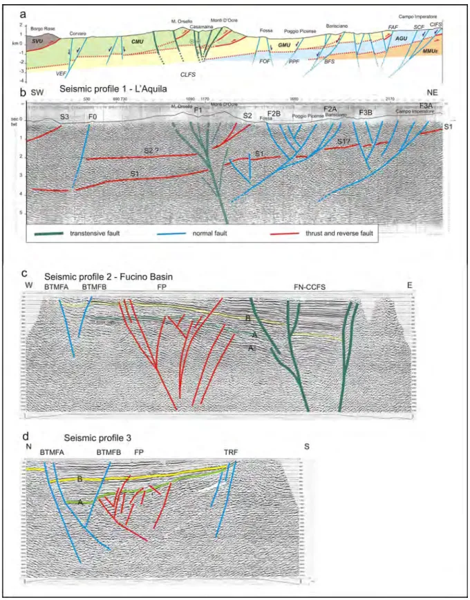
Fig. 4 - a) Geological cross-section across the study area; b) NE-SW seismic profile IT 89-01: (The geological cross-section is drawn along the same trace of the seismic profile); c) 1-80-AZ-03 E-W seismic profile in the Fucino Plain; d) 1-82-AZ-05 N-S seismic profile in the Fucino Plain. Explanations of acronyms in the text
faults (F2B, F3B) are stopped at the intersection with the F2A and F3A main fault planes. This tectonic framework is in agreement with that identified in the superficial part of the Paganica sub-basin through seismic tomography by iMProta et alii (2012).
The SW sector shows a structural setting less disjointed than the NE one. Only a normal, high-angle, SW-dipping fault (F0) is identified on the seismic section. Outside this fault, the S2 and S1 thrust planes are continuous or not significantly displaced.
The other important seismic sections are 1-80-AZ-03 and 1-82-AZ-05, which cross the Fucino Plain approximately in E-W and N-S directions (Figs. 1, 4c and 4d). These sections made it possible, inter alia, for us to verify the continuity to the south of some structures identified on the northern IT-89-01 seismic section.
A very concise representation of the Upper Pliocene-Quaternary structural framework of the Fucino Plain is shown in Fig. 1. Also, we re-interpreted the VIDEPI seismic sections 1-82-AZ-02, 1-80-AZ-04, 1-80-AZ-06, 1-80-AZ-10, AQ 319-85-V (Fucino area) and RI-315-85, RI-313-84319-85-V, 3-84, CAM-2-84, CAM-5-84, and CPT-1-84 (Lake Campotosto/Cittareale areas) to examine the local details of some faults.
Seismic section 1-80-AZ-03 (Fig. 4c) which crosses the median sector of the Fucino Plain E-W, presents some well-structured and continual reflections, such as the horizons A and B (except the two ends). The N-S seismic section 1-82-AZ-05 (Fig. 4d) crosses the eastern sector of the Plain and intercepts the previous seismic section.
In the upper part of the recording of both seismic sections, there are two more evident seismic reflections that separate intervals with different characteristics. The lowest, A, an erosional surface, in agreement with CaviNato et alii (2002), is extensively involved
in the tectonic evolution of the area and deepens considerably to E, where it ceases to be recognizable. Horizon A was identified by VIDEPI as the top Miocene carbonates. According to our study, horizon A formed as a result of an erosional process that developed in this sector in the Upper Messinian (see Geological Setting). The probable boundary between carbonates and Miocene terrigenous deposits is marked by A0.
Horizon B marks the transition between a lower depositional sequence that is somewhat irregular, discontinuous, sometimes lenticular, and coarsely structured, and an upper depositional sequence that is more regular and homogeneous. The lower sequence is strongly influenced by the faults of the FP flower structure; W and E of FP, the lower sequence tends to become a little more regular and continuous. Above horizon B there is a series of generally well structured and roughly parallel seismic horizons belonging to a sedimentary sequence of lacustrine, fluvial-lacustrine and detrital deposits (CaviNato et alii, 2002).
In more detail in particular, two seismic reflections above the B erosion surface appear to be a discontinuous sedimentary succession (pinch out towards W and maybe towards S) whereas The seismic section IT-89-01 is the key element because
it crosses the whole central area affected by the 2009 L’Aquila seismic sequence (Figs.1, 2, 4b and 5). It trends NE-SW and is orthogonal to the main structural lineaments so it is possible to recognize the real subsurface structural pattern and to distinguish the structures involved in the 2009 L’Aquila seismic sequence. Low angle compressive structures (S1, S2, and S3), all NE-vergent and SW-dipping, and extensional structures (F0, F1, F2, F3) have been recognized. Among the low angle compressive structures, the most evident is the S1. This structure is characterized by well organized and continuous reflections together with evident angular unconformities (from 730 to 1090 shot points, hereafter s.p., around 3 sec TWT depths). The most continuous reflection corresponds to a thrust fault plane, while the unconformal reflections highlight different lithostratigraphic horizons inside the overridden units or minor and antithetic thrust fault planes. To the SW (from s.p. 690), the S1 plane deepens through a ramp till 3.7 sec depth. The front of the S1 structure is external to the NE boundary of the seismic section.
The S2 is an embricated-fan thrust with two main fault planes. The easternmost is low-angle while the westernmost is high-angle; they join at 1.2 sec depth. From s.p. 1090 to 530, at around 2 sec depth, there is a low angle continuous and wavy horizon with some angular unconformities, the latter being interpreted here as the SW extension of S2, although it may possibly be another thrust plane. At s.p. 530, the horizon S2 is offset by a SW-dipping high angle normal fault (F0). The S3 thrust front consists of a single low-angle fault.
The F1 structure (Fig. 4b) is a NE-dipping high angle fault system which reaches great depths (>4.5 sec) and offsets the S1 and S2 planes. The upper part of this structure consists of several branches, high and lower angle NE (mainly) and SW-dipping, joining at < 2.5/3 sec TWT; the lower part, below 3 sec, consists of one (or two sub-parallel) high angle, NE-dipping fault plane(s). In the deeper part, between F1 and F2A, there is an especially complex zone with several local faults that are NE and SW-dipping; these faults are compressive and slightly offset the S1 but not the F2A lower fault plane. F1 is a flower structure and the main structure of the seismic section, as it divides the seismic section into two very structurally different sectors: the NE sector and the SW one.
The NE sector is characterized by several NE and SW-dipping low and high angle normal faults, which in some cases can be recognized up to the surface horizons of the seismic section. Within this sector, there are two main fault systems, F2A and F3A, which are SW-dipping and reach considerable depths (about 4 sec TWT; 9/10 km b.s.l.). The dip plane of these two fault systems becomes less steep with increasing depth. Furthermore, the faults show wavy and ramp-flat geometries (in particular F3A), but overall they have a dip angle of 45°. The antithetic, NE-dipping
Fig. 5 - Map of M≥2 epicentres of 2009 L’Aquila seismic sequence (ISIDE Data base, INGV). Yellow: aftershocks epicentres (April 06th - September 30th, 2009); orange: foreshock epicentres October 01st, 2008 – April 05th, 2009). a, b and c seismic boxes. 1, 2, 3 and 4 traces of the structural-seismolog-ical cross-sections of Fig. 8. Main faults delimiting the seismic boxes
There is also a slight tilting toward E of this sequence part. The FP structure is older than the FN, BTMF and TRF ones. Indeed, in FP some faults are sealed from the horizon B and just the main ones offset it with very low displacements. Instead, in FN, BTMF and TRF the fault planes can be seen up to the shallow horizons of the seismic section, also with significant vertical displacements (about 200/300 m). The vertical displacements of the FP faults, both in correspondence with the horizons A and B, are small (<25/30 m) probably because they belong to a predominantly transcurrent structure.
The comparison between the geological cross-section and the seismic sections shows the following corrispondences (Figs 1, 2 and 4): starting from the SW side of the geological cross-section (Fig. 4a), the Salto Valley Unit (SVU) overrides onto the Cicolano-Marsica Unit (CMU); the thrust plane corresponds to S3 of the seismic section (Fig. 4b); the Mt. Velino Fault (VEF) corresponds to F0. Regarding the areas between Corvaro (Mt. Velino) and Mt. Orsello, a correspondence in the seismic section has not been identified for the SW and NE-dipping normal faults and the minor Mt. Orsello thrust of the geological section (Fig. 4b), because of their limited length, depth and very low offsets. Further NE, the TS, OM and CR faults of the geological cross-section correspond to the three main branches of the CCFS. TS, OM and CR merge in the depth into a single, high-angle, NE-dipping, deep seated flower structure of Fig 4b. At the NE of the Monti d’Ocre Range, the embricate-fan Mt. d’Ocre Thrust corresponds to S2. In the Middle Aterno Valley, the NE-dipping normal fault (FOF) of the geological cross-section belongs to anthitetic faults (F2B) of the F2 Fault System. The SW-dipping main fault of the F2A system corresponds to the western structure of the Barisciano structural high (BFS)(Figs 2, 4a and 4b). The SW and NE dipping normal faults of the Campo Imperatore sector belong to the F3 Fault System; in particular, the main fault of F3A corresponds to the Campo Imperatore Fault System (CIFS). In the more eastern part of the geological cross-section, the AGU overrides the MMUE by the low-angle, SW-dipping plane of the Gran Sasso thrust, which could be in correspondence with the S1 plane of Fig. 4b.
Finally it is to be emphasized that the two structural sectors mentioned in the description of the seismic section IT-89-01 correspond to the W and E-Domains, divided by CCFS, described in the chapter “Geological setting”.
The Fucino Plain, about 30 Km south of the town of L’Aquila, is filled with loose, upper Pliocene-Quaternary continental deposits (Fig. 1); therefore, the correlation with the outcropping structures is not direct as in the previous case, but requires a more detailed description. On the Fucino Plain subsurface, some important tectonic structures and two erosion surfaces, respectively referable to an event at the pre-beginning of Apennine deformation (A) and to a post-compressional phase (B), have been recognized. On the basis of geological knowledge and the evolution of the area, the the reflection immediately above B is continuous and parallel to
B. The whole sequence above B dips and thickens towards the E (where its bottom reaches about 1200 milliseconds/~ 1000 m depth) and N (where its bottom reaches about 600 milliseconds/~ 500 m depth). The first two seismic reflections above B, being similar and parallel, indicate a regular sedimentation in a flat basin, while the upper pinch out sedimentation shows the, progressive and consistent lowering to E and N of the same basin. In seismic section 1-80-AZ-03, three groups of tectonic structures can be identified:
• to the west, just a small graben, whose faults displace the seismic horizons A and B;
• in the central part, a highly branched structure with mostly high-angle, W- and E-dipping reverse faults (positive flower structure, hereinafter FP) that offset widely, albeit with minimal offsets, horizon A and, only locally, horizon B (a quite similar interpretation of this structure is also found in the original VIDEPI seismic section);
• in the eastern part, a very branched structure with high-angle W- and E-dipping normal or transtensive faults (negative flower structure with the two main branches joining at just under 3 sec TWT, hereinafter FN), that cut the seismic horizons A and B with very evident offsets.
Some faults of all these structures displace or deform the most superficial reflections of the seismic recording.
Seismic section 1-82-AZ-05 crosses the Fucino Plain in an approximately N-S direction. To the north there is a system of normal or transtensive faults (hereinafter BTMF), consisting of mainly S-dipping faults (with the exception of a N-dipping antithetic fault characterized by minimal but very evident vertical displacement) that dislocated the seismic horizons A and B (displacement 300 msec, 150/200m) and virtually the entire sedimentary sequence, including the most recent horizons and shallow reflections. At the center there is a deep structure (FP) consisting of S- and N-dipping high to medium angle reverse faults that cut the seismic horizon A broadly (with offsets of a few tens of meters) and the seismic horizon B only marginally. To the south, there is a system of N-dipping normal or transtensive faults (TRF) that cuts the seismic horizons A and B, with displacement of a few tens of meters. At the FN, BTMF and TRF structures, the whole sedimentary sequence over B as well as the underlying one is strongly displaced by the main normal faults, whereas at the FP structure it is only locally affected by faults with weak vertical offsets. Between the two main E- and W-dipping faults of the FN structure (FNa and FNb), the sedimentary sequence over B is thicker; it differs from the one immediately to the west because of its alternation of very regular and thin sedimentary layers (probably fine grain size lacustrine) with other more irregular and perhaps coarse species in its medium-low part; this area corresponds to the central-east part of the so-called “Bacinetto”.
edge, up to where they are interrupted to the east against FN. It consists of two high-angle, SE-dipping (main) and NW-dipping (antithetic) normal or transtensive faults. Also this fault system shows remarkable Quaternary activity. BTMF represent the southernmost part of the staircase fault system known in the literature as the Tre Monti Fault (368, Avezzano Geological sheet-APAT, 2006c), which is the western prolongation of the Celano-Bussi Fault (CBF-CeNtaMore et alii, 2002) or a segment
of the Avezzano-Bussi Fault (ghisetti & vezzaNi, 1999). Other
normal or transtensive Quaternary faults are present at the western and southern edges of the Plain, and are, respectively, E- and N-dipping (Figs. 1 and 4c-d).
In the light of these considerations, the Fucino depression began structuring in the late Upper Pliocene-early Lower Pleistocene, when the central Apennines began to be affected by extensional and regional uplift processes (DraMis, 1993;
CaviNato et alii, 2002; CeNtaMore & Nisio, 2003; CeNtaMore
& rossi, 2009).
SEISMOTECTONIC
The L’Aquila seismic sequence developed from October 2008
(PoNDrelli et alii, 2010) through all of 2009 and afterwards. This
study focuses on the sequence up to September 30th, 2009 (Figs.
5 and 6), which according to the data reported by ChiaraluCe et
A surface is younger than the Salinity Crisis (Sequence M2, early Upper Messinian; CeNtaMore & rossi, 2009) and the B surface
is early Upper Pliocene (CaviNato et alii, 2002; CeNtaMore &
DraMis, 2010, a.r.t.). Two groups of structures have also been
identified: the more recent one consists of transtensive faults (FN negative flower) that widely and diffusely displace the B surface; the older one consists of compressive or strike-slip faults (FP positive flower) largely sealed from the B surface. The main faults in the first group, develop all along the eastern edge of the Plain and are the continuation of the CCFS system. They are high-angle, NE- and SW-dipping, normal or transtensive faults with remarkable Quaternary activity. Parts of these faults on the surface are known in the eastern Fucino Plain as the San Benedetto-Gioia de’ Marsi Fault (galaDiNi et alii, 1997; Ciotoli et alii, 1998),
the Parasano and Serrone faults (PiCCarDi et alii, 1999) or the
Parasano-Cerchio Fault (laveCChia & BoNCio, 2006). The main
buried faults have clear morphostructural evidence and are visible in the ASTER images; also at the FN main faults, on the surface, widespread and important coseismic effects occurred during the 1915 earthquake (oDDoNe, 1915; girauDi, 1988; SERVA et alii,
1986; galaDiNi et alii, 1997; MiChetti et alii, 1996).
Another important system of the first group consists of ENE-WSW trending buried faults (BTMF, Buried Tre Monti Fault) that cross the Plain approximately in its central-northern
Fig. 6 - A) Map of M≥2 earthquake epicentres of the 2009 L’Aquila seismic sequence occurred in the first day (April 06th, 2009): yellow dots – Southern seismic box (a); red and green dots - Intermediate seismic box (b); grey - uncertain attribution (for more details see text).
(ChiaraBBa et alii, 2009; ChiaraluCe et alii, 2011a; 2011b;
valoroso et alii, 2013; Fig. 7); these authors have sought to identify
seismogenic faults on the basis of the plot in depth of a large amount of hypocenters of earthquakes of any magnitude and time. This method can generate ambiguities in the correlations. In fact, without any tectonic reference structure, different clusters of hypocenters have been joined by creating a presumed and fictitious fault plane. In this way, in some cases not real or only partially real fracture
alii (2011b) can be considered significant because of the number
and energy of the seismic events. In this period, there were just over 3,200 earthquakes of M=>2, 75 of which were foreshocks (Mmax=3.9), while the rest were aftershocks (including the 4/6/2009 main shock of MW=6.1).
The specific seismic characteristics of this sequence have been discussed extensively by several authors, with special effort to identify the fault plane geometry of seismogenic structures
Fig. 7 - Map of the L’Aquila entire seismic sequence showing a seismological dataset of 64k moderate magnitude earthquakes (redrawn and modified after Valoroso et alii, 2013)