DIPARTIMENTO DI SCIENZE DELL’AMBIENTE FORESTALE E DELLE SUE
RISORSE
CORSO
DI
DOTTORATO
DI
RICERCA
IN
ECOLOGIA
FORESTALE
–
XX
CICLO
A NEW GIS-BASED SPATIAL MODELLING
APPROACH FOR DESERTIFICATION RISK
ASSESSMENT IN THE MEDITERRANEAN AREA.
AN ITALIAN CASE STUDY: SARDINIA ISLAND
Settore Scientifico Disciplinare – AGR/05
Dottorando: Monia Santini
Coordinatore: Prof. Paolo De Angelis
Tutori:
Co-Tutore:
Prof. Riccardo Valentini
Dr.ssa Paola Molinari
Index
INTRODUCTION 1
1. THE DESERTIFICATION ISSUE 5
1.1. INTRODUCTION 5 1.2. DEFINITIONS OF DESERTIFICATION 6 1.2.1. Land Degradation 6 1.2.2. Causes 7 1.2.2.1. Climate 9 1.2.2.2. Human activities 10
1.2.3. Manifestations and Effects 10
1.2.4. Reversibility 11
1.2.5. Threatened areas 11
1.3. ACTIONS AGAINST DESERTIFICATION 15
1.3.1. World action 15
1.3.2. European Actions 15
1.3.3. Italian Actions 16
1.4. DESERTIFICATION AS A RESEARCH ISSUE 16
1.4.1. First approaches 16
1.4.2. The indicators 18
1.4.3. D.P.S.I.R. framework 19
1.4.4. Projects regarding desertification 20
2. DESERTIFICATION IN THE STUDY AREA AND NEW APPROACH 28
2.1. INTRODUCTION 28
2.2. THE STUDY AREA: ISLAND OF SARDINIA 28
2.2.1. General description of the area 28
2.2.2. The desertification phenomenon in Sardinia 30
2.2.2.1. Agriculture 32
2.2.2.2. Pastoral activities 32
2.2.2.3. Urbanisation 33
2.2.2.4. Quarrying and mining activities 34
2.2.2.5. Water resources contamination 35
2.2.2.6. Fires 35
2.2.2.7. Soil erosion 35
2.2.2.8. Decline in organic matter 36
2.2.3. Previous regional experiences: state of the art 36
2.3. THE NEW PROPOSED METHODOLOGY 41
2.3.1. Vulnerability and risk 42
2.3.2. Why models? 42
2.3.3. Why GIS? 43
2.3.4. The methodology 43
2.3.5. Spatial and Temporal scale 45
2.3.6. Models 45
2.3.7. Relative importance of the degradation processes 46
2.3.8. The Integrated Desertification Index (IDI) 46
2.4. TOOLS AND SOFTWARE 48
3. THE WATER EROSION ASSESSMENT MODEL - RUSLE 50
3.1. INTRODUCTION 50
3.2. DESCRIPTION OF THE MODEL 50
3.3. PARAMETERIZATION AND MODIFICATIONS TO THE MODEL 51
3.3.2. K factor: soil erodibility 52
3.3.3. LS factor: topography 54
3.3.4. C factor: vegetation cover 56
3.3.5. P factor: management practices against erosion 57
3.4. PRODUCTION AND FORMAT OF INPUT DATA 57 3.4.1. Erodible areas 58 3.4.2. R factor 59 3.4.3. K factor 60 3.4.4. LS factor 62 3.4.5. P factor 63 3.4.6. C factor 64
3.4.7. Other input data 65
3.5. SIMULATION AND RESULT DISCUSSION 66
4. THE OVERGRAZING ASSESSMENT MODEL - CAIA 71 4.1. INTRODUCTION 71
4.2. DESCRIPTION OF THE MODEL 71
4.3. PARAMETERIZATION AND MODIFICATIONS TO THE MODEL 73 4.4. PRODUCTION AND FORMAT OF INPUT DATA 76 4.4.1. Sustainable CAIA 76
4.4.2. Actual CAIA 76
4.4.3. Output structure 76
4.5. SIMULATION AND RESULT DISCUSSION 77
5. THE VEGETATION PRODUCTIVITY ASSESSMENT MODEL - MOD17 79 5.1. INTRODUCTION 79
5.2. DESCRIPTION OF THE MODEL 79
5.2.1. The GPP algorithm 80
5.2.2. Examples of validation of the model 81 5.3. PRODUCTION AND FORMAT OF INPUT DATA 83 5.3.1. Radiation use efficiency, Tmin_scalar and VPD_scalar 84
5.3.2. Climatic Data 85
5.4. GIS-BASED TOOL 85
5.5. SIMULATION AND RESULT DISCUSSION 86
6. THE SOIL PRODUCTIVITY ASSESSMENT MODEL - CENTURY 90
6.1. INTRODUCTION 90
6.2. DESCRIPTION OF THE MODEL 90
6.2.1. Examples of validation of the model 91 6.3. PRODUCTION AND FORMAT OF INPUT DATA 94 6.3.1. Textural data 97
6.3.2. Field capacity and wilting point 97
6.3.3. Density 97
6.3.4. Soil Organic Carbon (SOC) 97
6.3.5. Climatic data 98
6.3.6. C and N of litter, roots, stems and leaves 98 6.3.7. Final database 98
6.3.8. “.100” file creation 99
6.3.9. Output structure 100
6.4. SIMULATION AND RESULT DISCUSSION 100
7. THE WIND EROSION ASSESSMENT MODEL - WEAM 104
7.1. INTRODUCTION 104
7.2. DESCRIPTION OF THE MODEL 105
7.2.1. Threshold wind friction velocity 105
7.2.3. Examples of validation of the model 107
7.3. PARAMETERIZATION AND MODIFICATIONS TO THE MODEL 110 7.3.1. Particle Size Distribution 110
7.3.2. Wind friction velocity 112
7.3.2.1. Soil moisture factor 112
7.3.2.2. Roughness factor 113
7.4. WEAM SIMULATION TOOL 113
7.5. PRODUCTION AND FORMAT OF INPUT DATA 114
7.5.1. Erodible areas 114
7.5.2. Soil roughness 114
7.5.3. Textural composition 115
7.5.4. Vegetation/soil drag coefficient 115
7.5.5. Daily climatic data 116
7.5.6. Leaf Area Index (LAI) 116
7.5.7. Other input data 118
7.6. SIMULATION AND RESULT DISCUSSION 118
8. THE SEAWATER INTRUSION ASSESSMENT MODEL - SHARP 120
8.1. INTRODUCTION 120
8.1.1. The physical process 121
8.2. DESCRIPTION OF THE MODEL 123
8.2.1. Boundary terms 124
8.2.2. Leakage terms 124
8.2.3. Sources and sinks 125
8.3. PARAMETERIZATION, MODIFICATIONS TO THE MODEL AND CRITICALITY 126
8.3.1. Criticality of the data availability in Sardinia 126
8.4. PREPARATION AND FORMAT OF INPUT DATA 127
8.4.1. Non spatialized input data 129
8.4.2. Spatialized input data 129
8.4.2.1. Aquifer data 129
8.4.2.2. Well data 131
8.5. SIMULATION AND RESULT DISCUSSION 132
9. ANALYSIS OF IDI RESULTS 135
9.1. INTRODUCTION 135
9.2. IDI APPLICATION 135
9.2.1. Standardization of model results 135
9.2.1.1. Normalization of erosion model results 136
9.2.1.2. Normalization of productivity model results 141
9.2.2. Weighting the indices 144
9.3. IDI RESULTS 146
9.3.1. Extraction of hotspots 148
9.3.2. Comparison of IDI with a simplified-IDI 149
9.3.3. Field verification 150
9.3.4. Geographic characteristic influence over IDI 154
9.3.5. Risk evaluation on a basin scale 155
9.3.6. Risk evaluation on a municipality scale 156
9.3.7. Risk evaluation on a land use scale 158
10. METHODOLOGY APPLICATION AT LARGER SCALE: ”PARTIAL-IDI” 159 10.1. INTRODUCTION 159
10.2. TEST AREA: RIO MANNU 159
10.3. NEW INPUT PRODUCTION 161
10.3.1. Pedologic Map 161
10.3.3. Precipitation data 162
10.3.4. Normalization Difference Vegetation Index 163
10.3.5. Digital Elevation Model (DEM) 163
10.4. APPLICATION OF THE MODELS TO TEST-AREA 163
10.4.1. RUSLE 163 10.4.2. WEAM 169 10.4.3. MOD17 170 10.4.4. CENTURY 171 10.4.5. CAIA 172 10.5. PARTIAL-IDI 173
11. FUTURE SCENARIOS OF DESERTIFICATION 176
11.1. INTRODUCTION 176
11.2. MODELLING OF LAND USE CHANGE 176
11.2.1. CLUE-s model 176 11.2.1.1. Main Principles 176 11.2.1.2. Driving factors 177 11.2.1.3. Model Description 177 11.2.1.4. Spatial Analysis 178 11.2.1.5. Decision rules 179 11.2.1.6. Allocation 180 11.2.1.7. Model limits 181
11.3. CLUE-S IMPLEMENTATION IN THE STUDY AREA 181
11.3.1. Driving factors 182
11.3.2. Land use 185
11.3.3. Statistical analysis 186
11.3.4. Land Use demand 187
11.3.5. Decision rules and elasticity 189
11.3.6. Convergence criteria 189 11.3.7. Restriction 190 11.4. SCENARIOS OF IDI 191 11.4.1. CENTURY 192 11.4.2. SHARP 192 11.4.3. RUSLE 192 11.4.4. WEAM 192 11.4.5. CAIA 192 11.4.6. IDI estimation 193 CONCLUSIONS 197 REFERENCES 199 ANNEX A 208 ANNEX B 218 ANNEX C 219 ANNEX D 221 ANNEX E 223
Introduction
1
Introduction
Desertification is land degradation occurring in arid, semiarid and dry sub-humid areas of the world. These susceptible territories cover about the 40% of the earth's surface and put at risk more than 1 billion people who are dependent on these lands for survival.
Desertification is acknowledged as the process which turns productive into non-productive land resulting from wrong land-management and overexploitation. Because of the common link between the desertified areas and aridity conditions, this issue was in the past mainly related with the one of climate changes, leading most areas of the world toward more and more hot-dry conditions. But in the last two decades it arose the idea that desertification is strictly dependent on the wider issue of global changes, including climate but also transformation of land use and management.
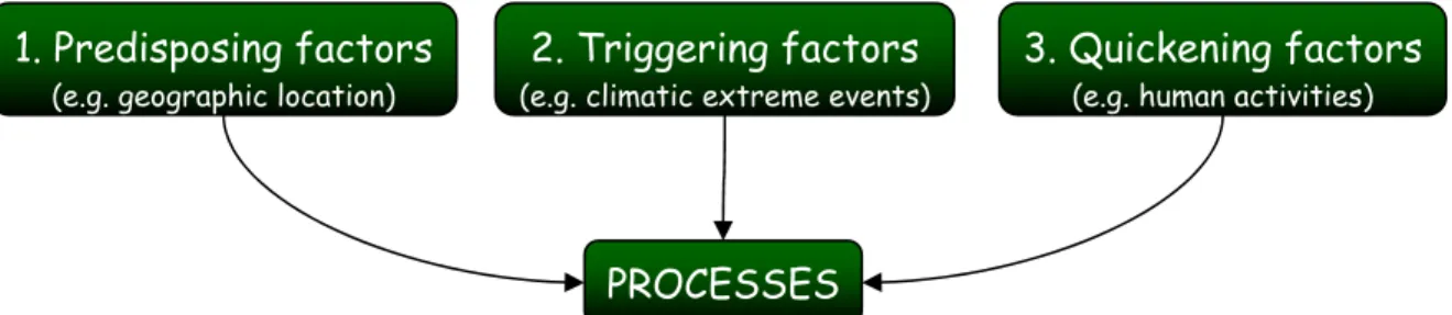
Treating it the same way than another natural hazard, the desertification can be thought as due to three types of factors: i) predisposing factors, related to natural conditions of an area; ii) triggering factors, given by extraordinary climatic events; iii) accelerating factors, caused by anthropogenic actions; anyway it is often difficult to distinguish among them. In this sense, desertification is considered a “human-induced” natural hazard.
Indeed degradation of lands relates to a combination of excessive human exploitation, that oversteps the natural carrying capacity of the land resource system, and inherent ecological fragility of the system. These features usually affect the main categories of ecosystem components: soil, vegetation and water resources, manifesting themselves with the worsening of the quality and the availability of these resources fundamental for life. Numerous on site and offsite effects of processes related to desertification can be resumed in a series of losses for the ecosystems:
- loss of biological productivity; - loss of economic productivity;
- loss of heterogeneity in the landscape.
Anyway, despite various definitions and concepts in defining causes and effects, the main element of the phenomenon distinguishing it from land degradation is its irreversibility: the probability that altered ecosystems will not return to the former state, even after human pressure is removed, constitutes the real concept of desertification. Combining the fragility of ecosystem, the natural hazards of drought and the excessive human pressures the system would be seriously damaged and without corrective interference of society natural processes alone could not redress the damage.
Among factors related with the phenomenon, the human activities play a fundamental role, for this reason it is clear desertification not only affects drylands, but also moist lands. Land degradation/desertification is seen occurring in many different contexts: in cool-dry or warm-dry environments, in very arid or semi-arid climates, on different types of soil and in very different societies.
This extent of the problem drove numerous actions, at various spatial levels, in order to face the desertification spreading, involving often not only politicians and land managers, but also scientific researchers with the aim of better understanding the problem before to take decision and to plan prevention, mitigation or adaptation actions. Most of these approaches focused on assessing desertification ‘vulnerability’, that is the attitude of an area to suffer damages and losses due to the specific event, whereas there is a lack of products concentrated on desertification ‘risk’ that is an estimation of potential consequences over a territory for a given phenomenon. These two terms are often confused, but in dealing with natural hazard they have to be distinguished.
Anyway, until now research and politic activities aimed to the production of cartography to evaluate desertification extent and severity, favouring the development of numerous methods as direct observations and measurements, remote sensing, until empirical equations.
In particular, most of the efforts carried out in implementing a quantitative approach to assess desertification using the numerous concepts and definitions existing in literature are based on indicators, defined as parameters useful to synthesize and communicate qualitative or quantitative information relative to a phenomenon. The indicators often simplify the reality with
Introduction
the aim of quantify complex processes sometimes difficult to measure or observe.
Recently, the most useful indicators for assessing desertification are derived from the logic model known as DPSIR (Driving force-Pressure-State-Impacts-Responses), developed by the Environmental European Agency. Anyway, these widely used indicators, also if combined together in order to give a more exhaustive assessment of desertification, show several limits. First of all they are static and too simple to represent the complexity of processes occurring on the land and their interactions with biota, and not able to represent with reliability the continuously changing world. Secondly, they are inadequate in their capability to provide future scenarios, which is one of the most urgent problem to address climate change signal and human pressures in future land degradation predictions.
For this reason the necessity of a new approach arose, an approach that is: i) capable to quantitatively estimate the risk of desertification, making an evaluation of the vulnerability relatively to the land use of a given territory, and ii) not only diagnostic but also prognostic, permitting to produce scenarios. This work had the purpose of developing a methodology for creating a plausible and feasible model to identify areas vulnerable and at risk of desertification.
In particular this was made for desertification risk evaluation in Sardinia (Italy), aiming to assess desertification risk of this region that, since last decades, suffered from severe land degradation problems. In this context, the Autonomous Regional Government of Sardinia funded the project called “Design and implementation of a G.I.S. (Geographic Information System) to monitor the areas of Sardinia at risk of desertification, with the specific indication of the
components of this risk, included their parameterization”* that started in February 2005
(coordinated by Agriconsulting S.p.A. and ESRI Italia), and whose framework and implementation are the topic of this thesis.
The region of Sardinia is situated at the centre of western Mediterranean Sea; the Island is characterized by a high variability of landscapes due to their geologic, morphologic, pedologic and vegetation characteristics.
The study area, sharing many environmental characteristics with the other Mediterranean regions, shows a menacing interaction of soil erosion and overgrazing that affects the territory: the areas for breeding are often obtained through fires or ploughing to seed pasture on every kind of slope, making the soil more instable and susceptible to erosion, because of the removing of vegetation cover and the compaction of the soil, both increasing runoff processes. Among secondary factors of desertification in Sardinia there are the drought periods, the overexploitation of groundwater and consequent salinization, the high frequency and extension of firewood, the reduction of vegetation cover and the agricultural land abandonment.
We developed a new framework to assess desertification and land degradation based on a suite of models (in contrast with indicators) which are integrated in a Geographical Information Systems (GIS) environment and simulate a set of processes related to land degradation in the study area. We chose to couple GIS and models with the advantage of allowing environmental managers and scientists both to generate different scenarios simulating particular conditions and decisions both to display the outcomes in a spatial context, this functional for comparisons more easily than with tables, graphs or texts. But we differentiated our approach from the one of previous works, not only using models instead of indicators, but also distinguish the concept of vulnerability (i.e. the tendency if the territory to suffer from damages by desertification) from the one of risk (i.e. the gravity of the resulting damages according to the type of land exploitation).
This approach has the advantage to be dynamic and fully interacting with environmental and human variables, providing the possibility to derive future scenarios about desertification.
In particular our objectives were:
1) to assess the nature, the intensity and the relative influence of desertification factors; 2) to identify the direct and indirect impacts of desertification;
*
“
Progettazione e realizzazione di un Sistema Informativo Geografico per il monitoraggio delle aree della Sardegna a rischio di desertificazione, con la specifica indicazione delle componenti di tale rischio, compresa la parametrazione delle stesse”, bando G.U.C.E. serie n. S248-221050 del 24.12.2003Introduction
3 3) to develop an evaluation procedure for desertification risk assessment;
4) to detect the most critical areas (Hotspots);
5) to promote software applications as decision support tool; 6) to favour the diffusion and the exchange of information.
This thesis wants to present the rationale of the research, the methodological approach and the application and validation experience.
A large multi-thematic dataset was acquired, processed and re-arranged in a GIS environment in order to model six degradation processes frequent in the study area: overgrazing, soil erosion (by wind and water), vegetation degradation, soil degradation and seawater intrusion. When necessary, the maps of model results were normalized to adimensional indices varying from 0 (representing no degradation) to 1 (representing irreversible degradation). These procedures were applied for two different periods: the early nineties and the present. Resulting degradation indices were then integrated into a final one, combining different aspects of desertification processes: their magnitude and their development rate, weighting them according to their significance and to the quality of their input data. The final Integrated Desertification Index (IDI) was classified into five levels of increasing severity and the results where verified by means of field survey in sites resulting as areas at risk.
The thesis is organized as follow. In the first part (Chapter 1) we illustrate the issue of desertification, its occurring and facing at various spatial levels until focusing on the study area (Chapter 2) and its criticalities, also describing actions already carried out in assessing desertification vulnerability, producing several cartographic products, then we introduce the new developed evaluation methodology. In the second part (Chapters from 3 to 8) we describe the degradation models used in the procedures, the modification made on them, their parameterization and their results for the two periods of reference. Afterward, in the third part we discuss the results of the application of the new GIS-modelling based methods for the study area (Chapter 9), the experience of application of the same methodology on a test areas resulted at risk from the first application in order to evaluate the performance of the methodology on a larger scale (Chapter 10), and the experiment of application of the method to simulate desertification scenarios for the future, deriving it by coupling of climate change and land use change predictions (Chapter 11). In the conclusions we resume the results of the research. The Annexes aid in more detailed description of used database (Annex A) and of several procedures for database treatment (Annexes from B to E).
Chapter 1 – The Desertification Issue
5
1. THE DESERTIFICATION ISSUE
1.1. Introduction
The phenomenon known as desertification received extensive attention in last decades, since the time of the organization of the United Nations Conference On Desertification (UNCOD), hold in Nairobi in 1977, that was mainly a result of the impact of an extended drought in the West African Sahel in the early 1970s. That drought caused a loss of human lives and livestock and an invasive environmental deterioration. Although the role of the Sahelian drought in the increasing consideration of the desertification issue is commented in a lot of recent documents, papers and reports from many countries (e.g. Glantz, 1977; UN Secretariat, 1977), that drought was neither the first appearance of the desertification phenomenon nor the only reason for scientific interest in it (Glantz and Orlovsky, 1983). Indeed, despite the attention focused upon it in recent thirty years,
desertification was not a new phenomenon: similar droughts occurred in 1911 and 1940, but the
difference was that at the time of Sahelian episode television brought the images to the entire world. If we look at the historical occurrence during the last few centuries we can find three main epicentres of desertification: the Mediterranean region, the Mesopotamia and the Loessial Plateau of China. Particularly, what happened in the past two centuries is that the impact of human agricultural, industrial and extractive activities, when coupled with human induced climate variations, is leading to land degradation on an unprecedented extent.
The Nairobi Conference in 1977 provided the biggest attention to the phenomenon (UN Secretariat, 1977). It described desertification as: "...the diminution or destruction of the biological potential of
the land, which can lead ultimately to desert-like conditions…Desertification is a self-accelerating process, feeding on itself, and as it advances, rehabilitation costs rise exponentially. Action to combat desertification is required urgently before the costs of rehabilitation rise beyond practical possibility or before the opportunity to act is lost forever.”
So desertification is a general land degradation problem, and the land degradation can happen in many different contexts: in cool-dry or warm-dry environments, in very arid or semi-arid climates, on different types of soil and in very different societies, both ancient and modern, both with advanced technologies and with traditional ones, both rich and poor, both capitalist and socialist and so on.
As the desertification is such a complex phenomenon it requires the expertise of researchers in many different disciplines as climatology, soil science, meteorology, hydrology, range science, agronomy, veterinary medicine, as well as geography, political science, economy and anthropology. The concept has been defined in many different ways by researchers in those and other disciplines, as well as from many national and institutional perspectives, each highlighting different aspects of the phenomenon.
In particular desertification is of great interest to climatologists in their efforts to understand climate variations and changes on both short and long terms. Indeed, with increasing pressure on governmental decision-makers for allowing populations to move into the climatically marginal areas, the implications of natural variations in climate became even more important in decisions relating to the use by society of its land in desertification-prone regions.
One can easily assert that there will be always climatic deserts. However, man-induced extensions of these deserts or the creation of desert-like conditions in areas where they had never existed can and must be avoided. The climatologists both at national and international levels (e.g. World Meteorological Organization's Climate Programme and UNEP’s (United Nation Environment Program) World Climate Impacts Programme) have, in general, made the identification of the climatologic and meteorological aspects of desertification one of their most important priorities (Glantz and Orlovsky, 1983).
In this chapter we will focus on the general concept of desertification phenomenon and on its aspects as: its relationships with land degradation, its causes, its effects, the different degrees of the phenomenon severity (reversibility or not) and the extent of the phenomenon. Then we will introduce briefly the actions undertaken at various scales (global, continental, national) together
Chapter 1 – The Desertification Issue
with some information about the most diffuse and used approaches (mainly in a research context) in dealing with desertification.
1.2. Definitions of desertification
A review of the desertification literature shows a great confusion among definitions: there are numerous different descriptions of the process, giving the idea of the complexity of the phenomenon. This mix of meanings attributed to the concept leads to miscommunication among researchers, among policy-makers and, first of all, between researchers and policy-makers (Glantz and Orlovsky, 1983).
Within the hundreds of existing definitions of desertification, many words are used to describe the phenomenon, some of which complement each other while others appear to be contradictory. The point on which they all agree, anyway, is that desertification is viewed as an adverse environmental process. The negative descriptors used in these definitions of desertification include: deterioration of ecosystems (e.g. Reining, 1978), degradation of various forms of vegetation (e.g. Le Houerou, 1975), destruction and diminution of biological potential (e.g. UNCOD, 1978), decay of a productive ecosystem (e.g. Hare, 1977), reduction of productivity (e.g. Kassas, 1977), decrease of biological productivity (e.g. Kovda, 1980), alteration in the biomass (e.g. UN Secretariat, 1977), intensification of desert conditions (e.g. WHO, 1980), impoverishment of ecosystems (e.g. Dregne, 1976) and so on.
The first author defining desertification was Aubreville (1949) that looked at the phenomenon as a slow and underhand process but also as an event, which is the end state of a process of degradation. Each of used terms suggests changes from a favourable or preferred state (with respect to quality, societal value or ecological stability) to a less favoured one and each was used to describe the condition of vegetation, or moisture availability, or soil conditions, or atmospheric phenomena, depending on the particular definition. Other descriptors used in these definitions connote a movement or a transfer of the characteristics of a desert landscape into an area where such characteristics did not exist; these descriptors are: extension, encroachment, acceleration, spread, transformation etc. If one combines each of these negative and transfer descriptors with all the other factors cited in the existing definitions, desertification would include most kinds of environmental changes related to biological productivity.
AGENDA 21, one of the most important documents of the United Nations Conference on Environment and Development (UNCED, 1992), describes desertification as “…land degradation
in arid, semi-arid and dry sub-humid areas resulting from various factors, including climatic variations and human activities”. This definition is internationally accepted as the most complete
one for describing the desertification phenomenon, being also the one officially considered by the UNCOD (1978).
But finally Mainguet (1994), after a large review of the different definitions, concluded defining the process as: “the ultimate step of land degradation, the point when land becomes irreversibly
sterile in human terms and with respect to reasonable economic limitation”.
But this statement of the desertification perception needs to be further explained elaborating its five main concepts: (1) what is the “menace” (land degradation); 2) what are the “causes” (natural and anthropogenic); (3) what “effects” are produced by phenomenon; (4) the degree of “reversibility” of the phenomenon; (5) what are “the menaced territories” (drylands, but not only).
1.2.1. Land Degradation
There are in general two main concepts in approaching desertification issue:
- considering this as a loss of productivity of ecosystem caused by climatic condition changes and by human activities;
- considering desertification as a long time, complex and intricate process involving, as precursor, the land degradation.
Chapter 1 – The Desertification Issue
7 Indeed, some researchers consider desertification to be a process of change, while others view it as the final result (an event) of several processes of change (land degradation). This distinction underlies one of the main disagreements about what constitutes desertification.
Desertification-as-process has generally been viewed as a series of incremental (sometimes step-wise) changes in
biological productivity in arid, semi-arid and sub-humid ecosystems. It can include such changes as a decline in yield of the same crop or, more drastically, a decrease in the density of the existing vegetative cover. Desertification-as-event is the creation of desert-like conditions (where perhaps none had existed in the recent past) as the end result of a process of changes (Glantz and Orlovsky, 1983).
In both cases, the changes can be seen as prevailing only over the short term, with the degraded resource recovering quickly, or they may be the precursors of a strong deterioration process, causing a long-term and permanent alteration in the status of the resource. Land degradation therefore includes changes on soil quality, the reduction in available water, the diminution of vegetation resources and of biological diversity and the many other ways the overall integrity of land is menaced by inappropriate use.
Despite this work will focus on the study of the desertification problem, nevertheless some parts of the study such as those concerning causes, processes and indicators will address both concepts:
land degradation as fragmentary processes and desertification as the general phenomenon, since
they are closely interrelated.
1.2.2. Causes
There is a tendency to blame for desertification the land pressure due to the rapidly expanding population over the middle 20th century, but, although it greatly exacerbated this situation, there is a wider range of other causes to take into account.
Treating it in the same way than another natural hazard (e.g. landslides, earthquakes, floods, tsunamis), we can look at the desertification as a process caused by three different types of factors (Figure 1.1):
1. predisposing factors: related to natural conditions of an area, in general stable over the time
or anyway changing slowly if seen at a human time scale (e.g. topography, historical climate, vegetation and soil conditions, etc.);
2. Triggering factors: given by extraordinary climatic events;
3. Quickening factors: caused by anthropogenic actions (inadequate agricultural practices,
deforestation, fires, tourism, demographic increase, poverty conditions, urbanization and industrial, waste disposal, extractive activities, etc.).
Figure 1.1 – Scheme showing the three categories of factors causing in general natural hazard and in this case desertification-linked processes.
But these factors, in particular the ones comprised into the second and third category, tend to mix one another, indeed quickening factors (i.e. the “indirect” ones, as the green houses gas emissions from human activities) are the ones likely generating conditions influencing triggering factors (i.e. the “direct” ones, as the extreme climatic events).
Let’s think to an increasing of aridity conditions and/or to a larger frequency of drought phenomena in alternation with brief and intense rain in particular on poorly vegetated soil: this can cause high and rapid ground degradation, for the mechanical removal of its fertile portion. Then
1. Predisposing factors
(e.g. geographic location)3. Quickening factors
(e.g. human activities)2. Triggering factors
(e.g. climatic extreme events)
Chapter 1 – The Desertification Issue
“human” activities, together with the exploitation of upland and wooden areas for pasturage in a careless and irrational way, without an adequate planning, constitute a further disequilibrium element.
Another example is population concentration in the coastal zones and the intensive agrarian utilization in the adjacent territories determining water requirements that, often for a long period of the year, exceed the real availabilities. Consequently the excessive extraction from coastal aquifers often determines intrusion phenomena of sea water, that lead to the increase of desertification risk because of salting effects.
Land degradation, as key element of ultimate desertification, can be the result of causes both manifest and hidden, different from an area to another and also different in time; they also exist, of course, feedback mechanisms linking one another various physical, chemical, biological and economic processes and factors belonging to different categories of the scheme in Figure 1.1. Some researchers consider climate (drought, aridity, rain erosivity) to be the major contributor to desertification processes, with human factors playing a relatively minor role. Other researchers think the contrary. For example Le Houérou (1959) concluded that "on its edges the Sahara is
mainly made by man, climate being only a supporting factor" (quoted in Rapp, (1974)). In a recent
book on drylands the authors noted that in the absence of accurate paleoclimatological data "it must
be assumed that man is the most common cause, sometimes in combination with climatic variations but generally on his own" (Adams and Adams, 1979). A third group blames climate and man more
or less equally. For example Grove (1973) noted that "desertification or desert encroachment can
result from a change in climate or from human action and it is often difficult to distinguish between the two".
Each of these views can be considered valid, at least at the local level, and on a case-by-case basis. This suggests that there is a region-specific bias to perceptions about desertification, which goes far the general definitions. Debates about causes of desertification occupy a large part of the desertification literature and can only be summarized here.
In general desertification can be perceived as result of a long term failure to balance demand for ecosystem in drylands, in particular agricultural lands. Degradation of agriculturally used drylands relates to a combination of (1) excessive human exploitation that oversteps the natural carrying capacity of the land resource system, and (2) inherent ecological fragility of the system.
The driving forces of overexploitation include: increase in population and rise of human needs; re-orientation of rural production from subsistence economy to commercial economy (Kassas, 1995); cultivation of marginal land with a high risk of crop failure and a very low economic return; poor grazing management after accidental or man-made burning of semi-arid vegetation; removal or destruction of vegetation in arid regions, often for fuelwood; groundwater overexploitation that can cause seawater intrusion into coastal aquifer; incorrect irrigation practices in arid areas originating soil salinization, acidification or contamination which can prevent plant growth etc.
Following all these pressures, fragility of dryland ecosystems contributes because of (Kassas, 1992): rainfall limited and variable (recurrent incidents of drought, and consequent reduction of plant growth); reduced or thin plant cover, that does not give effective protection against erosion; low biological productivity (limited carrying capacity); softs skeletal (surface deposits showing little development), with consequent low content of organic matter.
Following Figure 1.2 shows a resume of this paragraph about the causes and processes of land degradation and desertification.
Chapter 1 – The Desertification Issue
9
Figure 1.2 – Logical framework relative to desertification causes.
In the following we will focus on the two main cited factors considered as the main cause of desertification.
Even if we were specifically talking about drylands, all that can be associated also to moist lands where the above mentioned factors/causes become more and more concomitant.
1.2.2.1.
Climate
References to climate in desertification definitions are related either to climate variability, climate change, and drought.
Climate variability refers to the natural fluctuations that appear in the statistics representing the
state of the atmosphere for a designated period of time, usually of the order of months to decades. Fluctuations may occur in any or all of the atmospheric variables (precipitation, temperature, wind speed and direction, evaporation, etc.). A result of those fluctuations may be the alteration of an ecosystem, and this could eventually affect societal activities that have been developed to exploit the productivity of that ecosystem.
Climate change refers to the view that the statistics representing the average state of the weather for
a relatively longer period of time are changing, and desertification is primarily a result of such natural shifts in climate regimes.
Drought episodes have also been cited as a major cause of desertification, since during such
extended dry periods desertification becomes relatively more severe, widespread and visible, and its rate of occurrence increases sharply. As the probability of droughts increases as one moves from the humid to the more arid regions, so, too, does the proneness to desertification.
In the effort of understanding the future direction of climatic impacts, climate models are considered the most valuable tool for long-term climate prediction and for the construction of regional scenarios, although they have limitations and uncertainties.
Most of climate models tend to produce somewhat too warm and dry regional scenarios (like for Southern Europe and the Mediterranean), it is important to assess the impact of future predictions on the hydrological system as well as on agriculture and forestry, as it was done in the European projects MICE (Modelling the Impact of Climate Change, http://www.cru.uea.ac.uk/projects/mice/)
DESERTIFICATION CAUSES
CLIMATIC VARIATIONS DROUGHT RAIN EROSIVITY WATER RESOURCES FIRES AGRICULTURE ZOOTECHNY URBANIZATION TOURISMWASTE DISPOSAL AND MINING ACTIVITIES NATURAL HUMAN PREDISPOSING FACTORS FRAGILITY OF ECOSYSTEMS LITHOLOGY HYDROLOGY PEDOLOGY MORPHOLOGY VEGETATION DEGRADED AREAS DEGRADATION PROCESSES SOIL EROSION
ORGANIC MATTER LOSS SALINIZATION
CONTAMINATION POLLUTION
Chapter 1 – The Desertification Issue
and PRUDENCE (Prediction of Regional Scenarios and Uncertainties for Defining EuropeaN Climate change risks and Effects, http://prudence.dmi.dk/).
1.2.2.2.
Human activities
We can divide human activities that affect land degradation roughly into two realms. The first is the agricultural sphere, which includes cropping and pastoral activities that affect agro-ecosystems. The second are those activities that affect the ecology of natural or quasi-natural ecosystems. Cultivation, herding and wood-gathering practices, as well as the use of technology, have all been cited in the definitions as major contributors to the desertification process in arid, semi-arid and sub-humid areas.
Cultivation practices that can lead to desertification include: land-clearing practices, cultivation of
marginal climatic regions, cultivation of poor soils and inappropriate cultivation tactics such as reduced fallow time, improper tillage, drainage, and water use. For example, areas that might support agriculture on a short term basis may be unable to do so on a long-term sustained basis.
Rangeland use that can lead to desertification includes excessively large herds for existing range
conditions (leading to overgrazing and trampling) and herd concentration around human settlements and watering points. Government policies towards their pastoral populations can also indirectly lead to desertification by, for example, not pursuing policies that encourage herders to cull their herds, by putting a floor on grain prices and a ceiling on prices that pastoralists might receive for their livestock, and so forth.
Gathering fuelwood by itself or in combination with overgrazing or inappropriate cultivation
practices creates conditions that expose the land to existing "otherwise benign" meteorological factors (such as wind, evaporation, precipitation runoff, solar radiation on bare soil, etc.), thereby contributing to desertification.
The use of technology in arid, semi-arid and sub-humid environments is the result of the policy-makers' desire for economic development. Thus, deep wells, irrigation and cash-crop schemes, each in its own way, can increase the risk of desertification processes in an area. It has been shown that desertification can result from road building, industrial construction, geological surveys, ore mining, settlement construction, irrigation facilities, and motor transport (Glantz and Orlovsky, 1983).
1.2.3. Manifestations and Effects
The costs of land degradation and desertification are most often measured in terms of lost productivity: UNEP estimates that economic losses from desertification are more than $42 billion each year.
In the text of the UNCCD (United Nation Convention to combat Desertification, 2004), are highlight the following effects caused by desertification/land degradation:
- loss of biological productivity; - loss of economic productivity;
- loss of heterogeneity in the landscape.
According to UNCCD the consequences of desertification include undermining of food production, famines, increased social costs, decline in the quantity and quality of fresh water supplies, increase poverty and political instability, reduction in land’s resilience to natural climate variability and decreased soil productivity.
Thus, desertification reduces the ability of land to support life, affecting wild species, domestic animals, agricultural crops and people. It is clear that the reduction of plant cover accompanying desertification leads to accelerated soil erosion by wind and water. Then, as vegetation cover and soil layer are reduced, rain drop impact and run-off increase. As consequence, water is lost off the land instead of infiltrating into the soil to provide moisture for plants. Furthermore, a reduction in plant cover also results in a reduction in the quantity of humus and plant nutrients in the soil, and
Chapter 1 – The Desertification Issue
11 plant production drops further. As protective plant cover disappears, flood become more frequent and more severe.
Different definitions of effects focus on changes in soil (e.g. salinization), or vegetation (e.g. reduced density of biomass), or water (e.g. waterlogging), or air (e.g. increased albedo). Most of them, regardless of primary emphasis, also describe changes in biological productivity, with comments related to the type, density, and value of vegetation.
From this analysis we evince that desertification is self-reinforcing, i.e. once the process has started, conditions are set for continual deterioration and effects that trigger other causes.
1.2.4. Reversibility
Several other concepts are important in studying desertification: the sustainability or the ability of the land to remain productive over long time periods; the resilience or that quality of a resource that makes it sustainable or resistant to degradation and, finally, the reversibility of the process.
Few documents deal with the issue of reversibility of desertification. Le Houérou (1975), for example, explained briefly the conditions under which desertification might be reversible. Others said that reversibility depends on the costs of rehabilitation of desertified areas as opposed to prevention. For example, Adams (IGU, 1975, p.133) suggested that the "reversibility of
desertification was a function of technology and the cost of rejuvenating an area... Irreversibility should refer to a situation in which the costs of reclamation were greater than the return from a known form of land use".
But others think that the end result of desertification is irreversible.
To evaluate desertification reversibility two considerations have to be taken into account : (a) when desertification might be reversed (i.e. the "time" factor), and (b) under what conditions (i.e. the "how" factor) (Glantz and Orlovsky, 1983).
First, desertification may be considered by some observers to be irreversible during a season or a few seasons but may be reversible on the scale of decades, or if not decades, perhaps centuries. One author has drawn a distinction between temporary and permanent desertification (WMO Secretariat, 1982).
In respect to how desertification might be reversed, the reversal might occur naturally, once the contributing causes have been removed, otherwise, human intervention might be required (e.g. Kassas, 1977) if there is a desire for the part of decision-makers to reverse it in less time than might be required to do so naturally.
For example, after the incidents of drought that cause failure of plant growth and the fauna dependent on it, with the return of normal rainfall the system could redress the damage. Even with prolonged drought (desiccation), the system may eventually recuperate after the event. But combining the fragility of ecosystem, the natural hazards of drought and the excessive human pressures the system would be seriously damaged and without corrective interference of society natural processes alone could not redress the damage. This is desertification.
1.2.5. Threatened areas
There is no agreement on where desertification can take place. Desertification occurs mainly in semi-arid areas (where average annual rainfall is less than 600 mm) bordering on deserts. But many researchers identify the arid, semi-arid, and sometimes sub-humid regions as the areas in which desertification can occur or where the risk of desertification is highest.
But looking at desertification as final step of land degradation, we can say that it is very world-wide spread, both in drylands and in moist lands. Drylands are territories where water income (precipitation) is less than the potential water “outflow” (evapotranspiration and consumption by plant growth), we mean their ratio is less than 0.65 during part of, or the whole, year. This shortfall is the measure of aridity (Aridity Index). Drylands are classified according to this measure into four zones (World Atlas of Desertification, UNEP, 1992, UNEP, 1997): hyper-arid, arid, semiarid and dry sub-humid. Table 1.1 (Kassas, 1995) provides estimates of categories of drylands in world
Chapter 1 – The Desertification Issue
continents. The hyper-arid territories are natural (climatic) deserts that are extremely arid (practically rainless). The arid and semi-arid territories are rangelands and rain-fed farmlands, the dry sub-humid territories are more bio-productive (woodlands, farmlands and pasturelands). The total area of these world drylands is 41% of the total land area of the world.
Table 1.1 – World drylands in millions of hectares (UNEP/GRID, 1991), modified from Dregne et al., 1991
.
Although the estimates of the extent of desertification range widely (Dregne, 1983; Mabbut, 1994; Oldeman and Van Lynden, 1998), all the above territories are areas prone to desertification. They are inhabited by about 900 millions of people, whereas, according to UNCCD, over 250 million people are directly affected by desertification.
Three agricultural land-use systems prevail: irrigated farmlands, rain-fed croplands, and rangelands. Table 1.2 summarizes the assessment (Dregne et al., 1991) of areas in the five continents that are at least moderately degraded. The extent of damage is highest in the rangelands (73% of all rangelands of the menaced drylands), and least extensive in irrigated farmlands (30% of irrigated drylands). Total agriculturally used drylands are 5159.6 million ha, and total damaged areas are 3562.1 million ha (69%).
Table 1.2 – Global status of desertification/land degradation in agriculturally used drylands (from Dregne et al., 1991)
Others imply that the areas prone to desertification might not be restricted to arid, semi-arid, or sub-humid regions, by using such descriptive words as “extension”, “encroachment”, and “spread” of desert characteristics into non-desert regions. Still others (e.g. Mabbutt and Wilson, 1980) refer to the “intensification” of desert-like areas.
Many others assert that desertification can only occur along the desert fringes. According to Le Houérou (1962), "desertification" can occur only in the 50-300 mm isohyet zone.
In reality, it is evident that desertification not only affects developing countries but also industrialized nations in semi-arid and dry sub-humid regions, where land degradation processes cause a severe reduction or loss of the biological and economic productivity.
In the early 1980s it was estimated that, worldwide, 61% of all productive drylands (lands where stock are grazed and crops grown without irrigation) were moderately to very severely desertified. The problem is clearly enormous.
Chapter 1 – The Desertification Issue
13 Practically there are two land use practices responsible for most of the world’s land degradation: deforestation to create cropland in the humid regions, and overgrazing in the drylands (UNEP, 1992). Soil erosion is the greatest problem in rain-fed cropland (affecting 47% of the land) whereas salinity and waterlogging are the main problems in irrigated drylands, affecting 30% of the lands (Glenn et al., 1998; Kassas, 1995).
It is predicted that global warming will increase the area of desert climates by 17% in the next century. The area at risk of desertification is thus large and likely to increase, damaging in particular agricultural areas (UNEP, 1992).Worldwide, desertification is making approximately 12 million hectares useless for cultivation every year.
Desertification and the consequent degradation of vulnerable ecosystems are problems that occur in all the European countries of the Northern Mediterranean, which is a complex mosaic of diversified landscapes. These Mediterranean countries such as: Spain, Portugal, Italy and Greece are considered by the UNCOD as potentially degraded areas.
In a Mediterranean context, desertification is considered as the consequence of a set of important processes, active in arid and semi-arid environments (Kosmas et. al, 1999). In particular, among all the previously cited processes of desertification, water erosion is the most intense and widespread in Europe (Poesen, 1995). The area of land with a high water erosion risk in the southern EU member states is remarkable (CEC, 1992), equal to about 10% of the rural land surface.
As in most other semi-arid regions, desertification in the Mediterranean region is largely a human-driven problem, which can be effectively managed only through a thorough understanding of the principal ecological, socio-cultural and economic driving forces associated with land use and climate change, and their impacts (MedAction, http://www.inea.it/medaction/documenti.cfm). Mediterranean land degradation is often linked to poor agricultural practices. Soils become salinized, dry, sterile and unproductive in response to a combination of natural hazards - droughts, floods, forest fires - and human-controlled activities, especially overgrazing. The situation was aggravated by the social and economic crisis in traditional agriculture in recent years and the resulting migration of people from rural to urban areas. The result is abandoned land, particularly on marginal and easily eroded hillsides, and weakened agricultural planning and land management. The modern economy is also contributing to the problem. Fertilizers, pesticides, irrigation, contamination by heavy metals and the introduction of exotic (invasive) plant species is undermining the long-term health of the soils of the region. Physical changes imposed on watercourses by the construction of reservoirs, the canalization of rivers and the drainage of wetlands are affecting land quality. Meanwhile, groundwater levels are declining widely, resulting among other things in saltwater intrusion into coastal aquifers. Some 80% of the region‘s available freshwater is used for irrigation. The dramatic and continuing growth of industry, tourism, intensive agriculture, and other modern economic activities along the coastlines is placing particular stress on coastal areas.
For that concerning Italy, various combinations of predisposing physical factors (aridity, drought, rain erosivity, morphology, orography, highly erodible soils) have augmented in our country the effects of degradations together with human pressures. Indeed Italy shares with the northern Mediterranean countries many of features above described.
In particular the desertification interests the areas of southern Italy (Sicily, Sardinia, Calabria, Apulia, Basilicata regions) exposed to climatic and human stresses. Also the central-northern regions (Tuscany, Emilia Romagna, and the Po river valley in general) show a deterioration of the climatic conditions and they are more and more susceptible to irregular precipitation, drought and aridity.
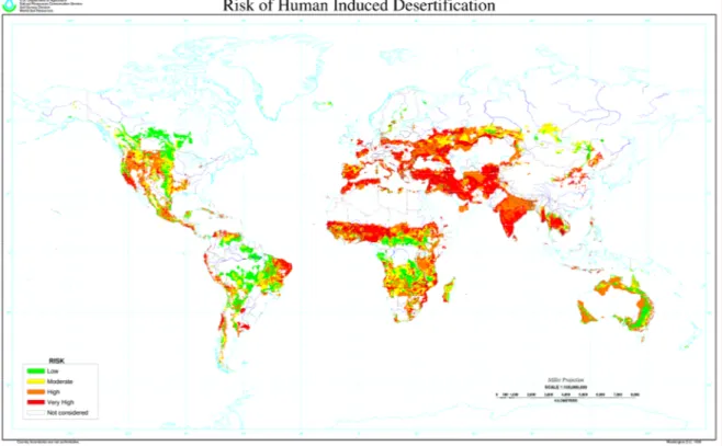
It was estimate that the 52% of Italian territory (Table 1.3) is exposed to risk of degradation processes: this is the study area considered for the production of the National Atlas of Areas at Risk of Desertification (supplied by the Istituto Sperimentale per lo Studio e la Difesa del Suolo - CRA), territory largely coincident with Mediterranean biogeographic region (EEA, 2002) and divided according to following Figure 1.3.
Chapter 1 – The Desertification Issue
Table 1.3 - Percent of surface at risk of desertification for Italian regions according to the National Atlas of Areas at Risk of Desertification (ISSDS – CRA).
Figure 1.3 – Spatial distribution of areas at risk for Italy according to the National Atlas of Areas at Risk of Desertification (ISSDS – CRA).
Chapter 1 – The Desertification Issue
15
1.3. Actions against desertification
1.3.1. World action
After stating that land degradation and desertification constitute a great problem with dramatic environmental, social and economic consequences, and after severe and protracted drought interesting African countries, the UN General Assembly decided to hold a UN Conference On Desertification (UNCOD) in 1977 in Nairobi (Kenya). The Conference produced a Plan of Action to Combat Desertification (PACD), a technically elaborate document: 28 recommendations each detailing actions to be carried out at the international, national and regional levels. The Action Plan became the framework for national and international action for the next 15 years under the general guidance of UNEP. These efforts reached a turning point with publication of the first edition of the World Atlas of Desertification (UNEP, 1992), which resulted in a revised edition (UNEP, 1997), and a subsequent series of program reviews (Dregne et al., 1991; Kassas, 1995). Despite the initial optimism, because of scarce resources, the implementation of PACD was limited.
The United Nations Conference on Environment and Development (UNCED, known as Earth Summit, Rio de Janeiro, June 1992) produced an action-oriented document: AGENDA 21. In its final version it represents a world consensus on what needs to be done. Chapter 12 Managing
fragile ecosystems: combating desertification and drought, addresses problems that are directly
related to our subject providing guidelines for elaboration of national plans of action for (1) managing of drought and (2) combating land degradation.
In 1994 the United Nations Convention to Combat Desertification (UNCCD) was signed in Paris, France, and entered into force on 1996. The aim of this treaty is to prevent and reduce land degradation, rehabilitate partly degraded lands and reclaim desertified ones. It deals with the extensive desertification phenomena of the northern Mediterranean countries and also addresses the problem in Central and Eastern Europe. The actuation of the Convention is at regional, sub-regional, national and local levels. For this reason, the Convention is completed by four annexes supplying guidelines to apply it in menaced territories, grouped into 4 geographic areas: Africa, Asia, South America/Caribbean, North Mediterranean.
The elaboration and implementation of Regional Action Programmes (RAPs) and National Action Programmes (NAPs), form helpful policy instruments to combat desertification and soil degradation phenomena in these areas. Until now, over 170 countries have accepted the Convention clearly demonstrating the global nature of the problem of desertification.
1.3.2. European Actions
It is specifically recognized that desertification and consequent land degradation are occurring in areas of Portugal, Spain, Italy and Greece.
The European Commission and its northern Mediterranean member states are signatory partners of the UNCCD. Indeed a sub-regional group (Greece, Italy, Portugal, Spain and Turkey) has already prepared and launched a Subregional Action Programme (SRAP) with the aim of delineate common strategies and programs, not only cooperating together with the Developing Countries but also by means of planning and intervention at regional, sub-regional and national levels. At regional level, activities are being undertaken particularly through the establishment of regional thematic networks for scientific cooperation.
European Commission (EC) promoted several activities for improving European research about desertification, by means of the Six Framework Programme (FP6), for the period 2003-2006. The section devoted to mechanism of Desertification focuses on “study the driving processes of the
desertification in the framework of likely scenarios of multiple stresses driven by land use changes and climate changes and development of methods and tools to achieve an integrated assessment”.
A great importance is given to the identification of indicators useful to assess the effects of land degradation and to the development of advanced modelling tools and actions. Furthermore, it is also established that all these strategies have to be developed in areas relevant to the UNCCD.
Chapter 1 – The Desertification Issue
Moreover, specific desertification research efforts at the European scale were also promoted by the EC including projects which have involved researcher from universities and research centres of different European countries working together and using an interdisciplinary approach in order to take into account all aspects concerning desertification.
These projects focused their efforts on providing reliable data and information sources, to increase the understanding of the causes of desertification, in order to forecast and combat it, as well as to mitigate the effects of on-going processes. The studies were carried out both at local and at regional scale, and environmental and socio-economic factors characteristics of the Mediterranean area were taken into account.
EU members are also investing in the systematic monitoring of land degradation, although there is still a need for a better coordination of the collection, analysis and exchange of data, including the countries outside the EU.
1.3.3. Italian Actions
Italy is considered to be one of the countries affected by desertification as comprised in the Annex IV of the UNCCD. At national level the Convention provides that these nations are adopting specific NAPs (National Action Plans).
In 1997 the Italian government instituted the National Committee to Combat Drought and Desertification (CNLSD, Comitato Nazionale per la Lotta alla Siccità e alla Desertificazione), with the task of coordinating the actuation of Convention. The committee includes components representing different cultural realities with the aim of facing desertification in its environmental, social, economic and scientific aspects. The main principle of NAP is implement the interventions and their integration both at national and local level. The NAP provides that the Region governments and the River Agencies find in their territory the areas vulnerable to desertification and define proposals of intervention to adopt in these areas, focusing on four main sectors:
- soil protection;
- sustainable resource management;
- reducing impact of productive activities; - re-equilibration of the territory.
The NAP focus over a fundamental concept, the desertification vulnerability: if it is easy to understand a desertified area, as it is sterile, it is more difficult to detect an area vulnerable to desertification and even more at risk of desertification (see Chapter. 2 for vulnerability/risk distinction).
1.4. Desertification as a research issue
1.4.1. First approaches
Desertification has been the subject of much activity and research in the physical sciences, inside four main broad areas (Thomas, 1997): i) attempting to assess, as reliably as possible, the extent and nature of the problem and the rate at which it might increasing or diminishing (at global, national and regional scale); ii) attempting to identify the physical processes of desertification in order to understand how systems subject to degrading disturbances actually function and change; iii) aiming to identify appropriate remedial actions to stabilize or recover lands subject to desertification; iv) to assess the relationship between desertification and environmental problems and natural hazards occurring in drylands, including recent explorations of the position of desertification in the context of predicted anthropogenically-induced global climate changes.
Despite the link with the physical sciences, desertification, with its social impacts and human causes, is also an issue in the domain of the social sciences.
Desertification assessment has shifted from simple evaluation of the interannual movement of the desert boundaries to complex multivariate field surveys, to practical methodologies based on indicators of ecosystem functioning (e.g. rain use efficiency).
Chapter 1 – The Desertification Issue
17 Lamprey (1975) attempted to quantify the rate of advancing of the Sahara by comparing the location of the southern margin at two different times: the year 1958, according to a vegetation map produced by Harrison and Jackson (1958), and the year 1975, according to aerial and terrestrial surveys conducted by Lamprey (1975). During this 17 year period, he observed a 90–100 km displacement, thus concluding that desert edges were encroaching at about 5.5 km per year. This prompted many, a posteriori ineffective, anti-desertification actions.
After Sahelian tragedy in early 70s’, desertification studies diversified using multidimensional methodologies.
For example, the FAO/UNEP (1984) method was summarized by a matrix whose rows are quantitative and qualitative variables of vegetation and soil. The columns are classes of degree of desertification (slight, moderate, etc.). The elements of the matrix are, in the case of quantitative variables, the range of values of each variable corresponding to each degree of desertification status (Table 1.4). In the case of qualitative variables, there are verbal descriptions instead of values. Individual sites whose desertification status needs to be determined are visited and actual values or descriptions are recorded. The elements of the matrix are then integrated in an unexplained way into a single index that summarized the desertification status of a site into one of four classes: slight, moderate, severe and very severe (Table 1.4). The most well-known result produced by this approach was the estimation that 70% of all drylands were affected by desertification (UNEP, 1992).
Table 1.4 – FAO’s matrix. Example of the criteria for the evaluation of the desertification status proposed by FAO/UNEP (1984)
But this methodology presents at least two problems: the first one is the subjectivity if data are not a measure, the second one is that this is a time-consuming methodology. Furthermore, this methodology is diagnostic but not prognostic.
Chapter 1 – The Desertification Issue
Then we can understand how the need to develop a practical and objective methodology based on indicators which were applicable and readily interpretable across different regions was an important lesson from the 1980s and early 1990s attempts.
1.4.2. The indicators
In the sphere of dealing with desertification, the European Environmental Agency introduced the use of indicators as “parameters or values derived by other parameters, supplying numerous
information relative to a phenomenon. They are quantitative information that help in explaining how some situations or conditions evolve in the space and in the time. The indicators often simplify the reality with the aim of quantify several phenomena and of communicating them” (Gentile,
1999). The indicators are very useful to efficacy describe some complex processes unless difficult to measure or observe (Rubio and Bochet, 1998).
We can define an indicator in several ways: variable, parameter, measure, statistical measure, fraction, value, index etc. In general it can be both quantitative and qualitative. Indicators can be further aggregated in indices allowing a simultaneous evaluation of different changing factors; moreover they can be used to elaborate responses and actions and to predict future impacts of human activities over the environment and society.
It is possible to use indicators to: i) determine conditions and environmental changes in respect to the society and development processes; ii) analyze causes and effects in order to supply useful decisional tools for responses to and prevention of a phenomenon; iii) individuate trends to predict potential impacts of human activities to decide future political strategies.
We can know indicators at different spatial scales: local, national and continental. The chosen scale influences the observation duration of the phenomenon, moreover the data gathering to create indicators has to be based over a network of observations that will be representative for various systems over which the land degradation process acts. At this time, thanks to Remote Sensing and GIS disciplines, more and more indicators can be generated directly at the desired scale. It is fundamental to know what kind of indicators are more appropriated for each scale.
The indicators have to be temporally sensible to changes. If we consider those characteristics of systems prone to degradation that modify themselves in few weeks or in many years, we have not an appropriate indicator. In general, the best indicators about the quality and degradation of the various system components are the ones showing significant changing in few years. We have also to specify that the validity of an indicator changes if they change also the data used to evaluate it. We can observe, indeed, that some characteristics change very slowly (e.g. topography and stream network), other ones in mid-term (e.g. vegetation and type of erosion), other ones very fast, as seasons or one year (e.g. soil moisture and grazing management).
At this regard researchers speak of “fast” and “slow” variables. In terms of biophysical variables, crop yield, for example, would be a fast (or quickly changing) variable whereas soil fertility, which affects yield, is a slowly changing variable. In terms of socio-economic variables, household debt would be a fast variable whereas market access, which affects debt, is a slowly changing variable. Anyway, it is clear that, in the context of desertification, the indicators are variables that show the land degradation, but not necessarily are able to “control” it.
The complex desertification phenomenon, caused by different and interrelated factors, cannot be described by a single indicator or measure (e.g. aridity index) but we need a set of indicators, each one describing an aspect of the process (Enne and Zucca, 2000). Various research projects and national institution efforts proposed some indicators and models to organize them, in particular within specific target areas (e.g. in the European projects MEDALUS (Mediterranean Desertification And Land Use), MEDACTION (Policies for land use to combat desertification) and DESERTLINKS (combating DESERTification in Mediterranean Europe: LINKing Science with Stakeholders)).
Indeed while earlier research work was more concentrated on the physical dimension of desertification, the focus has been adjusted more on the involvement of local stakeholders and research on social, economic and institutional dimensions of desertification. In connecting these
Chapter 1 – The Desertification Issue
19 multi-disciplinary dimensions of the desertification problem, much knowledge has been gained on suitable indicators, such that European research has led to substantial progress in this field.
In particular, we should remember that DESERTLINK project (http://www.kcl.ac.uk/projects/desertlinks/) developed a system of key indicators (Desertification Indicator system for Mediterranean Europe (DISforME)), and it is a very useful tool for monitoring desertification processes in Mediterranean area and for helping in decision support system.
1.4.3. D.P.S.I.R. framework
The logic model known as DPSIR (Driving force-Pressure-State-Impacts-Responses), developed by the EEA and showed in Figure 1.4, was used to classify efficiently the information and to identify that key set of indicators better describing desertification phenomenon and the relationships and feedbacks among them.
.
Figure 1.4 – Relationship among various indicators (and their description) according to DPSIR framework
The DPSIR framework is fundamental to organize information about environmental state. It assumes relationships of cause-effect among the social-economic and environmental components. The STATE indicators give an indication about the degradation of the lands at a given time. They can be qualitative and quantitative indicators, relative to the environment quality and determine its status from a temporal, spatial and functional point of view.