Full Terms & Conditions of access and use can be found at
http://www.tandfonline.com/action/journalInformation?journalCode=tjom20
Download by: [Universita G D Annunzio] Date: 19 June 2017, At: 07:23
Journal of Maps
ISSN: (Print) 1744-5647 (Online) Journal homepage: http://www.tandfonline.com/loi/tjom20
Morphotectonics of the Pescara River basin
(Central Italy)
Tullio Urbano, Tommaso Piacentini & Marcello Buccolini
To cite this article: Tullio Urbano, Tommaso Piacentini & Marcello Buccolini (2017)
Morphotectonics of the Pescara River basin (Central Italy), Journal of Maps, 13:2, 511-520, DOI: 10.1080/17445647.2017.1338204
To link to this article: http://dx.doi.org/10.1080/17445647.2017.1338204
© 2017 The Author(s). Published by Informa UK Limited, trading as Taylor & Francis Group
View supplementary material
Published online: 12 Jun 2017.
Submit your article to this journal
Article views: 39
View related articles
SCIENCE
Morphotectonics of the Pescara River basin (Central Italy)
Tullio Urbano, Tommaso Piacentini and Marcello Buccolini
Dipartimento di Ingegneria e Geologia (INGEO), Università degli Studi“G. d’Annunzio” di Chieti-Pescara, Chieti (CH), Italy ABSTRACT
This work presents a morphotectonic map of the Pescara River basin (1:40,000 scale), located in the piedmont-hilly area of the central-eastern Apennines (Abruzzo Region, Italy), and stretching from the eastern slope of the chain (Maiella Massif, Morrone Mt. and Gran Sasso Range) to the Adriatic coast. It is the outcome of an extensive drainage basin-scale geomorphological analysis and incorporates four main sections: orography and hydrography; morphotectonics; azimuthal analysis of the morphotectonic elements; Quaternary fluvial deposits and morphotectonic profiles. The morphotectonic map provides a basis for the study of morphotectonic features at basin-scale, the reconstruction of paleo-landscapes with special regard to drainage network evolution, and the recognition of tectonic control and selective erosion on the landscape. It also contributes to an outline of the main phases of the post-orogenic landscape evolution of the piedmont-hilly area of the Apennines, resulting from the link of alternating morphotectonic and surface processes.
ARTICLE HISTORY Received 16 November 2016 Revised 26 May 2017 Accepted 31 May 2017 KEYWORDS Geomorphological mapping; fluvial terraces; longitudinal profiles; drainage evolution; Pleistocene; Adriatic piedmont
1. Introduction
Determining the relative influence of tectonics, climate, base-level, and local factors on the evolution of the flu-vial system is key to understanding landscape dynamics (Bull, 2007; Schumm, 1977). In this context, an inte-grated geomorphological analysis of fluvial terraces in uplifting areas represents one of the most widely used methods to investigate the role of tectonic and climate forcing in controlling landscape evolution (e.g. Bridg-land & Westaway, 2008;Pazzaglia & Brandon, 2001).
In the Adriatic piedmont of the Italian Apennines, major valleys are characterized by a staircase of alluvial terraces that have developed since the Middle Pleisto-cene, and whose evolution is correlated with climatic oscillation and uplift processes (Coltorti, Consoli, Dra-mis, Gentili, & Pambianchi, 1991; Demangeot, 1965;
Dramis, 1992;Farabollini & Nisio, 1997;Nesci, Savelli, Calderoni, Elmi, & Veneri, 1995). The particular arrangement of Quaternary fluvial terraces in the Pes-cara River basin (Central Adriatic Piedmont) has attracted the attention of many researchers for a long time (Alberti, Lipparini, & Stamponi, 1962; Bonarelli, 1931; Carrara, 1998; Demangeot, 1965; Principi,
1930). More recently, studies of these features have
been carried out in the framework of the Geological
Map of Italy (APAT, 2006; ISPRA, 2010a, 2010b).
Most of these studies were undertaken at a local scale, missing a geomorphological characterization at a basin-scale. Furthermore, soft bedrocks of this region rarely preserve evidence of tectonic deformation,
making the analysis of geomorphic features a valuable tool in reconstructing the tectonic setting (Centamore, Ciccacci, Del Monte, Fredi, & Lupia Palmieri, 1996;
Currado & Fredi, 2000).
In this work, we present the morphotectonic map of the Pescara River basin, at a 1:40,000 scale, implemented with integrated geomorphological ana-lyses focused on hydrographic, fluvial/alluvial and morphotectonic features. As part of an extensive geo-morphological analysis in the central-eastern Apen-nines (Miccadei, Orrù, Piacentini, Mascioli, & Puliga, 2012b; Miccadei, Piacentini, Dal Pozzo, La Corte, & Sciarra, 2013;Miccadei, Piacentini, Gerbasi, & Daverio, 2012a; Piacentini, Sciarra, Miccadei, & Urbano, 2015;
Piacentini, Urbano, Sciarra, Schipani, & Miccadei, 2016; Santo et al., 2014; Sciarra, Coco, & Urbano, 2016), this map provides a basis for the study of mor-photectonic features at basin-scale and the reconstruc-tion of paleo-landscapes with special regard to drainage network evolution.
2. Study area
The Pescara River is located in the piedmont-hilly area of Abruzzo Region (Central Apennines), stretching from the eastern slope of the chain (Maiella Massif, Morrone Mt., and Gran Sasso Range) to the Adriatic coast for about 45 km (see physiographic map on the
Main Map upper-left slice). This river is fed by two main tributaries draining mountain basins (Aterno and Sagittario rivers) and by the Pescara springs, all
© 2017 The Author(s). Published by Informa UK Limited, trading as Taylor & Francis Group
This is an Open Access article distributed under the terms of the Creative Commons Attribution License (http://creativecommons.org/licenses/by/4.0/), which permits unrestricted use, distribution, and reproduction in any medium, provided the original work is properly cited.
CONTACT Tullio Urbano [email protected] Dipartimento di Ingegneria e Geologia (INGEO), Università degli Studi“G. d’Annunzio” di Chieti-Pescara, Via dei Vestini 31–66100 Chieti (CH), Italy
JOURNAL OF MAPS, 2017 VOL. 13, NO. 2, 511–520
located in the eastern chain sector. The overall hydro-graphic basin covers a surface area of some 3170 km2,
of which about 800 km2are in the piedmont-hilly area
(Pescara River basin stricto sensu).
The chain area shows a high-relief landscape dominated by resistant Mesozoic-early Tertiary (pre-orogenic) carbonate ridges and erodible Tertiary (syn-orogenic) siliciclastics valleys, and by Quaternary continental (post-orogenic) deposit-filled intermoun-tain basins (D’Alessandro, Miccadei, & Piacentini,
2003). The Adriatic piedmont fringes the easternmost
ridges of the chain and is characterized by a low-relief hilly landscape (i.e. hogback, cuesta, mesa reliefs) carved on Mio-Plio-Quaternary terrigenous deposits, related to syn-, late-orogenic phases of the Apennines, and by Quaternary marine regressive deposits and con-tinental deposits of post-orogenic phase. Here, the marine environment persisted until the Early Pleisto-cene, when the regional north-eastward tilting of the
area followed the main thrusting (Centamore &
Nisio, 2003) led to a sub-parallel (SW–NE)
arrange-ment of the main valley across the emerged coastal plain (D’Alessandro, Miccadei, & Piacentini, 2008;
Mayer, Menichetti, Nesci, & Savelli, 2003). Generalized tectonic uplift started in the Middle Pleistocene (D’Agostino, Jackson, Dramis, & Funiciello, 2001;
Pizzi, 2003), along with a series of glacial–interglacial
cycles linked with the Mid-Pleistocene climate tran-sition (e.g.Pisias & Moore, 1981), that forced alternat-ing phases of fluvial incision (at both warmalternat-ing and cooling transitions) and deposition (at cold stages), as recorded by a staircase of fill terraces recognizable
along the major valleys (e.g. Coltorti et al., 1991;
Nesci et al., 1995). According to a general classification, these terraces are arranged in no less than four different orders, commonly named T1 to T4, starting from the highest. These features are well exposed along the Pes-cara River basin that connects the drainage system of the eastern chain with the consequent one of the Adria-tic piedmont, playing an important role in the
Qua-ternary evolution of the Central Apennines
(Piacentini & Miccadei, 2014).
3. Methods
In order to define the role of morphotectonics in the evolution of the study area, an integrated drainage basin-scale study was carried out. Vector topographic
data (1:25,000–1:5000 scale) were provided byAbruzzo
Region (2007a, 2007b). A 5 m cell Digital Terrain Model (DTM) was processed from the 1:5000 scale vector map.
Orography (slope analysis and hypsometry) and hydrography analyses were based on the 5 m DTM and 1:5000 scale topographic maps (Ciccacci, D’ Ales-sandro, Fredi, & Lupia Palmieri, 1992;Strahler, 1952). The drainage network and sub-basins were digitized
from the 5 m DTM, controlled by means of 1:5000
scale orthophoto color images (Abruzzo Region,
2009) and then analyzed focusing on stream profiles
and pattern types (Hack, 1973;Howard, 1967;Twidale,
2004). The photogeology analysis was performed on
1:5000 scale orthophoto color images (Abruzzo Region,
2009) for preliminary mapping of the main landforms
(structural, fluvial and slope landforms, etc.), and on 1:33,000 scale air-photos (IGMI, 1954) for the mapping of the anthropized areas.
Field survey (scale 1:10,000) was carried out in the years 2013–2016, investigating bedrock, Quaternary continental (post-orogenic) deposits, and the main mor-photectonic elements (Centamore et al., 1996; Chelli, Segadelli, Vescovi, & Tellini, 2015; Ciccacci, Fredi, Lupia Palmieri, & Salvini, 1986; Griffiths, Smith, & Paron, 2011;Miccadei et al., 2013;Panizza & Castaldini, 1987; Picotti, Ponza, & Pazzaglia, 2009). Morphotec-tonic elements were classified according to their location in the landscape (ridges, slopes, valleys, hydrography forms, and fluvial terraces) and morphogenetics. The mapping was focused on the analysis of alluvial (terrace tread and strath, scarps, erosional surfaces) and hydro-graphic (hanging and beheaded valleys, counterflow confluences, and straight valleys) features, and their cor-relation to specific evidence of morphotectonics.
After a genetic characterization of terraced deposits during field mapping, the correlation of these deposits with the relative terrace level (order) was inferred by means of morpho-lithostratigraphic transverse pro-files. In this way, terrace levels within individual sub-basins, from the youngest to the oldest, were defined based on the heights of terrace surfaces (tread and strath when visible) above the bottom valley and on their morphological continuity. Then, the reconstruc-tion and comparison of the trend of terrace along different drainage sub-basins were computed via mor-photectonic transverse profiles, in which morphotec-tonic elements are portrayed, summarizing collected data. To better understand the longitudinal distri-bution of any single terrace level these data were plotted on a longitudinal profile, with the x-axis repre-senting the distance from the mouths of the basins. Local correlation, geochronological constraints (dating, paleosols, and lithic industries) and correlation with the neighboring valleys allowed us to outline Pleisto-cene–Holocene UBSUs (Unconformity-Bounded Stra-tigraphic Units, International Subcommission on
Stratigraphic Classification, ISCC, Salvador, 1994).
Finally, a statistical azimuthal analysis of the mapped morphotectonic elements considered more significant in the study of the fluvial landscape was performed. This analysis allowed us to define the connection and alignment of the elements along a specific orientation,
giving evidence of morphotectonic processes (Ciccacci
et al., 1986). The relationship between geomorphic evi-dence of tectonics and fluvial deposits is likely to
provide evidence of morphotectonics and contribute to determining its control on valley development, thus attempting relative geomorphological constraints in the timing of landscape development.
4. Results
The main features of the Pescara River basin are pre-sented on the morphotectonic map, which incorpor-ates four main sections, described in the following paragraphs.
4.1. Orography and hydrography section
From the east of the mapped area, the Pescara River
cuts the easternmost relief of the chain at the ‘gorge
of Popoli’. Downstream of the ∼7.5 km long gorge, it flows from 205 m a.s.l. down to the Adriatic Sea, col-lecting several minor tributary basins. The longitudinal profile has a concave shape, with a length of some 40 km and an average gradient of 5.12 m/km. The overall drainage basin covers a surface of some 800
km2in which three main sectors can be recognized:
(1) The chain front sector, including the eastern slopes of the southern Gran Sasso arc (e.g. Mt. Cappuc-ciata, 1801 m a.s.l.; Mt. La Queglia, 995 m a.s.l.) and of the northern Morrone Mountain (2061 m a.s.l.). To the southwest of the mapped area, the chain–piedmont boundary is more articulated due to the northernmost slope of the Majella mas-sif (2793 m a.s.l.);
(2) The piedmont sector, with elevations ranging from 700–800 m to 200–300 m, slopes from ∼50% to more than 100%, and local vertical scarps. This sector fingers the eastern chain front with a rugged to gentle (concave) morphology locally interrupted by deep and narrow incisions of the main water-courses; and
(3) The eastern hilly-coastal sector, mostly with tabular relief, at an elevation of <350 m a.s.l., slope value ≤50% but with some local high slopes to vertical scarps along the edges of the tabular relief. The orographic setting shows a main (Pescara) valley shifted to the far southern side of its basin, with limited steep slopes on the right side and large gentle slopes on the left side.
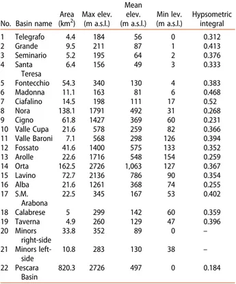
The whole Pescara River basin is divided into 22 sub-basins of which the main orographic parameters are defined inTable 1.
4.2. The main morphotectonic map section On the morphotectonic map, lithology and morpho-tectonic elements are represented. Outcropping lithol-ogies have been classified by their general geodynamic
context of formation (APAT, 2006; ISPRA, 2010a,
2010b). The description and numbers refer to the map legend.
4.2.1. Bedrock lithology
4.2.1.1. Pre-orogenic bedrock (1). The pre-orogenic marine bedrock is mapped as a single unit (limestone, marly-limestone, and calcarenite sequence) which includes different kinds of carbonate rocks belonging to the platform-to-basin depositional systems of
Trias-sic to Miocene age (APAT, 2006; ISPRA, 2010a), and
constitutes the relief of the chain sector (western mapped area). Along the western slope of the La Que-glia relief, a 3–4 m thick lamprophyre dike (1a) of Eocene age is intruded between two layers of limestone.
4.2.1.2. Early/syn-orogenic bedrock. The early/syn-orogenic marine bedrock comprises three main
sequences (APAT, 2006; Centamore et al., 1992;
ISPRA, 2010a):
. The marly-limestone, perlite and chalk sequence (2)
includes rocks of basinal (Upper Messinian–Lower Pliocene) and continental shelf (Lower Pliocene) environments, and it is mapped along the mountain front sector.
. The pelitic–arenaceous sequence (3) includes
turbi-dite rocks of Upper Messinian–Lower Pliocene age,
that extensively outcrops in the central-western mapped area.
Table 1. Orographic features (area, max, mean, and min elevation, hypsometric integral) for each drainage sub-basin of the Pescara River basin (number 1–22).
No. Basin name Area (km2) Max elev. (m a.s.l.) Mean elev. (m a.s.l.) Min lev. (m a.s.l.) Hypsometric integral 1 Telegrafo 4.4 184 56 0 0.312 2 Grande 9.5 211 87 1 0.413 3 Seminario 5.2 195 64 2 0.376 4 Santa Teresa 6.4 156 49 3 0.333 5 Fontecchio 54.3 340 130 4 0.383 6 Madonna 11.1 163 81 6 0.468 7 Ciafalino 14.5 198 111 17 0.52 8 Nora 138.1 1791 492 31 0.268 9 Cigno 61.8 1427 369 60 0.231 10 Valle Cupa 21.6 578 259 82 0.366 11 Valle Baroni 7.1 568 298 126 0.394 12 Fossato 41.6 1400 575 133 0.352 13 Arolle 22.6 1716 548 154 0.259 14 Orta 162.5 2726 1,063 127 0.367 15 Lavino 72.7 2136 786 90 0.354 16 Alba 21.6 1261 368 74 0.255 17 S.M. Arabona 22.5 345 167 53 0.402 18 Calabrese 5 299 142 60 0.359 19 Taverna 4.9 260 129 47 0.396 20 Minors right-side 33.8 352 89 0 – 21 Minors left-side 10.8 283 130 38 – 22 Pescara Basin 820.3 2726 497 0 0.184 JOURNAL OF MAPS 513
. The conglomerate sequence (4) represents the infill of lower Pliocene piggy back basins and is now recognizable in limited outcrops on the summit of the Fiore, Picca and Morrone mountains.
4.2.1.3. Late-orogenic bedrock.The Late-orogenic bed-rock comprises two main units which record a gradual transition from a marine depositional environment to a continental one (APAT, 2006;ISPRA, 2010a;2010b):
. The clay, sandstone, and conglomerate sequence (5)
consists of three main associations (pelitic-sandy, sandy-pelitic, and sandy-conglomeratic) showing a deepening-upward trend during the Late Pliocene p.p. and a shallowing-upward trend during the Early Pleistocene. This sequence crops out in the entire eastern hilly-coastal sector as a wide homo-cline gently dipping north-east in which pelitic-sandy and pelitic-sandy-pelitic associations are widespread along the valley bottoms and flanks respectively, whereas a sandy-conglomeratic association lies on the top of the mesa relief. Deltaic conglomerates and calcirudites (1a) are present at the base of this sequence, mapped between the Turrivalignani and Cepagatti villages.
. The conglomerate sequence (6) highlights a
tran-sition to a subaerial environment during the Middle
Pleistocene p.p. (Di Celma, Ragaini, & Caffau,
2016), and is mapped in outcrops of very small
extent within the Fontecchio basin. 4.2.2. Quaternary continental deposits
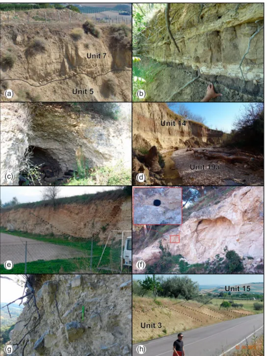
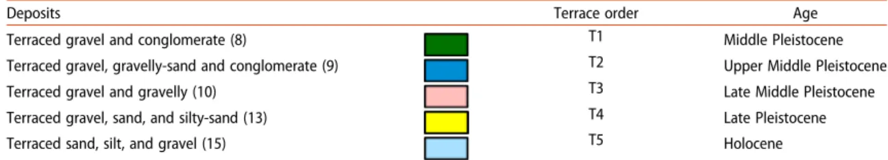
Quaternary (post-orogenic) continental deposits are listed below (units 7 to 20) and have been classified on the basis of their predominant morphogenetic pro-cess (fluvial and alluvial fan, fluvio-lacustrine, slope/ weathering, beach/deltaic and anthropogenic). A specific focus was devoted to terraced deposits (Figure 1).
Mapped fluvial and alluvial fan deposits are as fol-lows: terraced gravel and conglomerate (7), terraced gravel, gravelly-sand and conglomerate (8), terraced gravel and gravelly-sand (9), terraced gravel, sand and silty-sand (12), terraced sand, silt, and gravel (14), active and bankfull channel (19). The deposits of units 7, 8, 9, 12 and 14 are allostratigraphic units arranged in a staircase of fill terraces, often associated
with minor suites of strath terraces (sensu Bull,
1991). These units show a basal unconformity (strath)
typically carved across the bedrock (Figure 1(a)), with the exception of the youngest units (12 and 14) in the mid- and lower-Pescara valley, where they partly cut alluvium. The deposits of unit 7 are portrayed in few remnants of the piedmont sector. They usually constitute the top of the highest relief within sub-basins, but typically lie below the main basin divide. The deposits of unit 8 are widespread within the
Nora (Figure 1(b–c)), Cigno, Alba and Fontecchio
basins, and along scattered outcrops on the left side of the mid-lower Pescara River valley. The deposits of units 9 and 12 are mapped with great continuity throughout the Nora and Alba basins, and all along the left side of the upper and mid-lower Pescara River valley. The deposits of unit 14 are commonly
referred to as the ‘Holocene floodplain’ and outcrop
all along the valley floors of the Pescara River and of the lowest reaches of its main tributaries. Watercourses are now deeply entrenched within these deposits (Figure 1(d)), allowing us to define them as terraced units. From a general stratigraphic point of view, the upstream deposits of units 7, 8, 9, and 12 in the chain front areas show coarse alluvial fan facies (deb-ris-flow-dominated), whereas moving downstream they appear more fluvial-dominated. Along the Nora and Alba basins, great exposures of these units high-light a continuous lateral variation of facies from prox-imal, through mid-fan, to distal fan. In the central-eastern Pescara River valley, terraced deposits mainly
consist of gravelly braided-stream alluvium (Figure 1
(e)), even though units 9, 12, and 14 show a general fin-ing-upward trend characterized by coarse-grained and finer sediments at the lower and upper portions, respectively. This dichotomy is particularly evident on units 9 and 12, lying at the junction of tributary catchments with the main valley. The deposit of unit 19 has been divided into two sub-units: (a) active and (b) bankfull channel. The sub-unit 19a lies at the base of the narrow channels in major torrents and riv-ers with low gradient (Figure 1(d)), reflecting the influ-ence of the present flood regime. Sub-unit 19b is portrayed exclusively along the Pescara River and along the lowest reaches of its tributaries. Bankfull deposits outline the recent (after the mid-1900s) valley floors adjustment along the main watercourse, as well
evidenced in similar rivers of the Region (Piacentini
et al., 2016). Local correlation, geochronological data constraints (Agostini, 2003; Agostini, Di Canzio, & Rossi, 2001; Carrara, 1998;Marcolini et al., 2003) and
the correlation with neighboring valleys (i.e.
D’Ales-sandro et al., 2008;Della Seta et al., 2008) have allowed
us to outline at least five Pleistocene–Holocene UBSU
and infer their ages (seeTable 2).
Mapped fluvio-lacustrine deposits are terraced tra-vertine (11) and tratra-vertine (13). Terraced tratra-vertines (11) are discordant with the syn-orogenic bedrock and constitute the plate of the Tocco village on the right valley side (Figure 1(f)) and the nearby low relief of Vicenne on the left side. The travertine deposits of unit 13 are entrenched within the Terraced Travertines ones and constitute the flat bottom valley of the Casti-glione-Piano D’Orta area. These deposits have sedi-mented in basins closed by natural dams mainly
composed of autochthonous lithotypes (Carrara,
progressing downstream. Unit 11 dates back to the Late Pleistocene whereas unit 13 is of Holocene age.
Mapped Slope/weathering deposits are: ancient slope (10), eluvial–colluvial (15), landslide (16), scree slope (17). Ancient slope deposits (11) are por-trayed exclusively in the mountain front areas. Occasionally, they outcrop as small and isolated lobes hanging on mountain slopes, in which sedimen-tary features suggest a proximal alluvial fan
environ-ment (Figure 1(g)). Colluvial deposits (15) are
widespread throughout the basin, particularly at
toeslopes, on convex valley flanks, and within concave bottom valleys (areas with slope angle <20°). Fre-quently, these deposits are related to different sedi-mentation events (wedges), of which the oldest were
recognized along road cuts (Figure 1(h)). Eluvial
deposits (5) lie on the flat and gentle sloping tops of hills. Landslide deposits (16) and slope deposits (17) are related to several slope gravity processes and they outcrop with higher spatial density and size in the piedmont sectors. Deposits of beach/deltaic environment (18) and of anthropogenic origin (20)
Figure 1.Lithology of the study area (the units numbers and ages refer to the legend of the map): (a) strath contact between the clay bedrock (5) and fluvial (overbank) deposits belonging to unit 7 (at S. Caterina); (b) dark tephra level within the terraced deposits of unit 8 (at Colle Picconetto), interlayered with silty-clay palaeosols (lowest level indicated by the hand) and sheet-like silty-sand and arenaceous layers (upper layers); (c) fluvial conglomerate deposits (8) at Piano Scarpara; (d) channel incision of the Cigno Tor-rent highlighting the fine sediments of unit 14 with brownish topsoil; (e) fluvial channel deposits within the gravel of unit 9 and reddish topsoil; (f) travertine deposits of unit 11 (near Tocco village); (g) ancient slope deposits (10) of the upper Nora valley; and (h) colluvial deposits (15) characterized by four main wedges.
were grouped as‘Other deposits’. Ancient scree slope deposits date back to the late Middle Pleistocene. Other units (15, 16, 17, 18, and 20) date back to the Holocene, even though some older unmappable deposits have been observed.
4.3. Morphotectonic elements
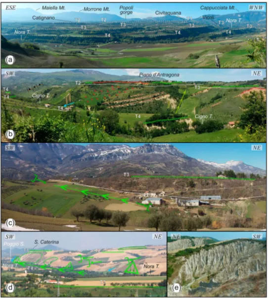
The study area is characterized by diverse landforms, heterogeneously distributed in relation to the morpho-logical, hydrographic and lithological setting (Figure 2) of the three main orographic sectors. A statistical azi-muthal analysis of morphotectonic elements highlights such connection and preferential alignment of these features.
4.3.1. Sector 1 (chain front)
The morphotectonic elements are mainly carved on pre-orogenic bedrock and their distribution is strictly influenced by lithostructural control and high slope angles. In the western chain front, N–S to NE–SW oriented structural scarps, hogback relief and straight (subsequent) valleys following the regional N-S trend of the thrust system overlapping pre-orogenic bed-rock on syn-orogenic bed-rocks. Along the mid-lower slopes, subsequent valleys bend in a general E orien-tation into main consequent valleys (e.g. upper Nora and Cigno streams). Vertical erosional deepening has helped the development of several and large mass movements with related landforms (landslide scarps and trenches). The northern culmination of the Maiella anticline is characterized by a wide N-dip-ping (10–15°) structural surface. This surface appears
deeply weathered and displaced by NW–SE faults, and
has therefore been mapped as several minor
‘struc-tural surfaces’. NW-SE local tectonics and dip-slope strata also influenced the straight and parallel drai-nage of this area.
4.3.2. Sector 2 (piedmont)
The morphotectonic arrangement of this sector is strictly influenced by the lithostructural setting of the thrust system, which here only involves the early/syn-orogenic bedrock. The main features are a narrow hog-back in the western relief and cuesta relief in the eastern-most areas, both oriented in a N–S to NE–SW direction, and associated subsequent valleys that join the main
consequent valleys with 90° or counterflow confluences. Main straight ridges, entrenched erosional surfaces and terrace scarps are mainly elongated in a NE–SW to NNW–SSE direction, evidencing linear incision pro-cesses along the straight subsequent valleys. The valley slopes are characterized by sharp vertical scarps and step-like slopes due to selective erosion of alternating sandstone and pelitic beds. In the lower Nora and
Cigno basins, the main valleys bend from SW–NE to
NW–SE; these deep valleys cut a SW–NE parallel drai-nage with associated hanging and beheaded valleys, tri-angular facets and counterflow confluences.
4.3.3. Sector 3 (hilly-coast)
The main drainage divide area is characterized by a structural surface on late-orogenic sandstone and con-glomerate sequence (top of the mesa relief). These sur-faces are often bounded by structural scarps and locally by landslide and/or degradational scarps. Beheaded valleys and saddles are mapped on the main drainage divide, and locally at the heads of small straight valleys, with a systematic orientation. Significant river bends and counterflow confluences are widespread in areas with an angular drainage pattern, mostly with the same orientations as the straight fluvial segments. Fluvial erosion scarps are mapped along the valley bot-toms, where they affect floodplain (unit 14) and channel (unit 19) deposits, but also landslide and colluvial depos-its. Terrace scarps are steeper where the streams have most recently swung against their base. Badlands were formed on clayey bedrock (unit 5) along the left side of the Pescara River basin and in the lower Nora valley. Most of these landforms are isolated and developed on S to SE facing slopes, except in the upper Arabona basin, where they are randomly grouped together, thus form-ing the typical calanchi landscape.
4.4. Morphotectonic profiles
Morphotectonic profiles consist of valley transverse and longitudinal profiles that have different horizontal and vertical scales for reasons to graphic and visual bal-ance. In the transverse profiles, morphotectonic elements are correlated to continental deposits, outlin-ing the distribution of the processes affectoutlin-ing the area (mainly fluvial and slope processes). The terraced deposits are drawn below the topography and the
Table 2.Correlation of fluvial and alluvial fan terraced deposits (colors refer to the lithological units of the map), terrace orders, and Pleistocene–Holocene UBSU.
Deposits Terrace order Age
Terraced gravel and conglomerate (8) T1 Middle Pleistocene
Terraced gravel, gravelly-sand and conglomerate (9) T2 Upper Middle Pleistocene
Terraced gravel and gravelly (10) T3 Late Middle Pleistocene
Terraced gravel, sand, and silty-sand (13) T4 Late Pleistocene
height above the present valley is defined for each ter-race level (see tables in the profile section).
In the longitudinal profiles of the main valleys (Pes-cara, Alba, Nora, Cigno, and Fontecchio), terrace treads show a general downstream convergence geo-metry, even though the Pescara profiles appear more articulated at the confluences with the main tributaries. The Alba, Nora, and Cigno profiles are characterized by a physical continuity of tread levels, in which the knickpoint of modern streams have a lithostructural control or correspond with changes in the cross-section morphology of the valleys.
5. Conclusion
The morphostructural setting of the Pescara River basin and the arrangement of the fluvial terraces were
analyzed through the morphotectonic map and sec-tions. Fluvial and alluvial deposits are arranged in five main orders of entrenched terraces (from the Middle Pleistocene to the Holocene), recording drai-nage evolution of the piedmont since its emersion. The transverse profiles show the relative incision of the fluvial terraces on the alluvial fan terraces and of the different terrace levels one into the other. The longitudinal convergent geometry of the terrace treads suggests the role of uplift in drainage development (Merritts, Vincent, & Wohl, 1994).
The remnants of the oldest alluvial fan surfaces (T1 and T2), on the top of the hilly reliefs and divides of the chain front areas, outline a landscape completely
differ-ent from the presdiffer-ent one– a Middle Pleistocene wide
piedmont plain on which large alluvial fans formed, as already observed in the northern Adriatic piedmont
Figure 2.Geomorphological features of the study area (symbols of morphotectonic elements are portrayed as in themain map): (a) panoramic view of the entrenched fluvial/alluvial fan terraces in the Nora valley (T1 = Middle Pleistocene; T2 = upper Middle Pleis-tocene; T3 = late Middle PleisPleis-tocene; T4 = Late Pleistocene); (b) structural scarps highlight the bedrock on which T2 and T3 terraces lie; (c) a hanging and beheaded valley with W–E orientation highlights a paleolandscape developed in the late Pleistocene (post T3 terraces) and subsequently dissected by N-S and SW–NE fluvial incision; (d) small hanging valleys, triangular facets, and counterflow confluences along the straight valley of the Poggio stream (Nora basin), possibly connected to lithostructural control (along WNE– ESE fractures and joints, also surveyed in the lowest Nora valley); and (e) badland areas in the uppermost reaches of the Arabona basin.
(Nesci & Savelli, 2003). These fans filled incipient leys that are now ridges bounded by newly formed val-leys on each side, evidencing inversion of relief processes (Pain & Oilier, 1995).
Between the Lower Cigno and Fontecchio streams, the spatial distribution of the T2, T3 and T4 terraces,
elongated in the SW–NE direction and entrenched
into the ancient fan surfaces and along both margins of the present valleys, indicates the development of a SW–NE consequent drainage starting in the upper Middle Pleistocene. This is confirmed by the SW–NE parallel pattern of the straight valleys and crests. In the lower portion of these valleys, the main streams make an abrupt bend (>60–90°), and then flow
down-stream into the Pescara River with straight WNW–ESE
and NW–SE orientations (parallel to the minor val-leys), cutting late Middle-Late Pleistocene terraces (T3 and T4). The resulting angular pattern of this sec-tor, along SW–NE,WNW–ESE and NW–SE orien-tations (with associated hanging and beheaded valleys, and counterflow confluences), indicates the control of local tectonics on drainage development along WNW–ESE and NW–SE faults and fractures and suggests that the age of these elements can be ascribed to the late Middle-Late Pleistocene.
In this context, the last phase of drainage incision related to Late Pleistocene–Holocene climatic changes resulted in the gradual organization of the drainage network to its present configuration, and indicates a main lithostructural control in the development of the current fluvial landscape.
Software
The vector/raster data and main map were managed
using Esri ArcGIS 10.1®, with final editing performed using Corel Draw®.
Acknowledgements
The authors wish to thank the Open Data service (http:// opendata.regione.abruzzo.it/) of Abruzzo Region for provid-ing the topographic data and orthoimages used in this work, and Silvano Agostini (Soprintendenza Archeologia dell’ Abruzzo) for providing archaeological data and helpful dis-cussion concerning the Quaternary geology.
Disclosure statement
No potential conflict of interest was reported by the authors.
Funding
The work was supported by the‘G. d’Annunzio’ University of Chieti-Pescara funds (T. Urbano, School of Advanced Studies ‘G. d’Annunzio’; T. Piacentini, Department of Engineering and Geology).
ORCID
Tommaso Piacentini http://orcid.org/0000-0002-5007-7677
References
Abruzzo Region. (2007a). 1:25,000 scale regional topo-graphic maps. L’Aquila: Struttura Speciale di Supporto Sistema Informativo Regione Abruzzo. Retrieved July 27, 2015, fromhttp://opendata.regione.abruzzo.it/
Abruzzo Region. (2007b). 1:5,000 scale regional technical maps. L’Aquila: Struttura Speciale di Supporto Sistema Informativo Regione Abruzzo. Retrieved July 27, 2015, fromhttp://opendata.regione.abruzzo.it/
Abruzzo Region. (2009). 1:5,000 scale orthophoto color images. L’Aquila: Struttura Speciale di Supporto Sistema Informativo Regione Abruzzo. Retrieved July 27, 2015, fromhttp://opendata.regione.abruzzo.it/
Agostini, S. (2003). La più antica preistoria. In Guida Geologica Regionale dell’ Abruzzo, Società Geologica Italiana (pp. 57–59). Roma: BE-MA Editrice.
Agostini, S., Di Canzio, E., & Rossi, M. A. (2001). Abruzzo (Italy): The Plio–Pleistocene proboscidean-bearing sites. In G. Cavarretta, P. Gioia, M. Mussi, & M. R. Palombo (Eds.), Proceedings of the 1st international congress“The World of Elephants” (pp. 163–166). Rome: Consiglio Nazionale Ricerche.
Alberti, A., Lipparini, T., & Stamponi, G. (1962). Note illustrative della carta geologica d’Italia alla scala 1:100000, Foglio 141‘Pescara’. Serv. Geol. It., Roma. APAT. (2006). Carta Geologica d’Italia alla scala 1:50.000,
Foglio 360‘Torre de Passeri’. Servizio Geologico d’Italia. Retrieved March 3, 2015, fromhttp://www.isprambiente. gov.it/Media/carg/360_TORRE_DE_PASSERI/Foglio.html
Bonarelli, G. (1931). Il Quaternario della Val di Nora in ter-ritorio di Catignano, Prov. di Pescara. Bollettino Della Società gEologica Italiana, 50, 113–116.
Bridgland, D. R., & Westaway, R. (2008). Climatically con-trolled river terrace staircases: A worldwide quaternary phenomenon. Geomorphology, 98, 285–315.doi:10.1016/ j.geomorph.2006.12.032
Bull, W. B. (1991). Geomorphic response to climatic change. New York, NY: Oxford University Press. 326 pp. Bull, W. B. (2007). Tectonic geomorphology of mountains: A
new approach to paleoseismology. Oxford: Blackwell Publications.
Carrara, C. (1998). I travertini della Valle del Pescara tra Popoli e Tor dè Passeri (Abruzzo, Italia Centrale). Il Quaternario, 11(2), 163–178.
Centamore, E., Adamoli, L., Berti, D., Bigi, S., Casnedi, R., Cantalamessa, G.,… Chiocchini, U. (1992). Carta geolo-gica dei bacini della Laga e del Cellino e dei rilievi carbonatici circostanti (Marche meridionali, Lazio nord-orientale, Abruzzo settentrionale). S.E.L.C.A. Firenze. Centamore, E., Ciccacci, S., Del Monte, M., Fredi, P., & Lupia
Palmieri, E. (1996). Morphological and morphometric approach to the study of structural arrangement of north-eastern Abruzzo (Central Italy). Geomorphology, 16, 127– 137.doi:10.1016/0169-555X(95)00138-U
Centamore, E., & Nisio, S. (2003). Effects of uplift and tilting in the central-northern Apennines (Italy). Quaternary International, 101–102, 93–101. doi:10.1016/S1040-6182 (02)00092-7
Chelli, A., Segadelli, S., Vescovi, P., & Tellini, C. (2015). Large-scale geomorphological mapping as a tool to detect structural features: The case of Mt. Prinzera ophiolite rock
mass (northern Apennines, Italy). Journal of Maps, 12(5), 770–776.doi:10.1080/17445647.2015.1072115
Ciccacci, S., D’ Alessandro, L., Fredi, P., & Lupia Palmieri, E. (1992). Relations between morphometric characteristics and denudational processes in some drainage basins of Italy. Zeitschrift Geomorph. N.F., 36(1), 53–67, Berlin – Stuttgart.
Ciccacci, S., Fredi, P., Lupia Palmieri, E., & Salvini, F. (1986). An approach to the quantitative analysis of the relations between drainage pattern and fracture trend. International Geomorphology, Part II, 49–68, Wiley, Chichester.
Coltorti, M., Consoli, M., Dramis, F., Gentili, B., & Pambianchi, G. (1991). Evoluzione geomorfologica delle piane alluvionali delle Marche centro-meridionali. Geografia Fisica e Dinamica Quaternaria, 14(1), 87–100. Currado, C., & Fredi, P. (2000). Morphometric parameters of drainage basins and morphotectonic setting of eastern Abruzzo. Mem. Soc. Geol. It., 55, 411–419.
D’Agostino, N., Jackson, J. A., Dramis, F., & Funiciello, R. (2001). Interactions between mantle upwelling, drainage evolution and active normal faulting: An example from the Central Appennines (Italy). Geophysical Journal International, 147(2), 475–497.doi:10.1046/j.1365-246X. 2001.00539.x
D’Alessandro, L., Miccadei, E., & Piacentini, T. (2003). Morphostructural elements of central-eastern Abruzzi: Contributions to the study of the role of tectonics on the morphogenesis of the Apennine chain. Quaternary International, 101–102, 115–124. doi:10.1016/S1040-6182(02)00094-0
D’Alessandro, L., Miccadei, E., & Piacentini, T. (2008). Morphotectonic study of the lower Sangro River valley (Abruzzi, Central Italy). Geomorphology, 102, 145–158.
doi:10.1016/j.geomorph.2007.06.019
Della Seta, M., Del Monte, M., Fredi, P., Miccadei, E., Nesci, O., Pambianchi, G.,… Troiani, F. (2008). Morphotectonic evolution of the Adriatic piedmont of the Apennines: An advancement in the knowledge of the Marche– Abruzzo border area. Geomorphology, 102(1), 119–129. doi:10. 1016/j.geomorph.2007.06.018
Demangeot, J. (1965). Geomorphologie des Abruzzes Adriatique. Mem. et Documents, Centre de Rech. et Documentation Cartogr. et Geogr., C.N.R.S., Paris. Di Celma, C., Ragaini, L., & Caffau, M. (2016). Marine and
nonmarine deposition in a long-term low-accommodation setting: An example from the middle Pleistocene Qm2 unit, Eastern Central Italy. Marine and Petroleum Geology, 72, 234–253.doi:10.1016/j.marpetgeo.2016.02.010
Dramis, F. (1992). Il ruolo dei sollevamenti tettonici a largo raggio nella genesi del rilievo appenninico. Studi Geologici Camerti, vol. spec. 1992(1), 9–15.
Farabollini, P., & Nisio, S. (1997). Evoluzione quaternaria del bacino del fiume Vomano (Abruzzo settentrionale). Il Quaternario, 10(1), 101–104.
Griffiths, J. S., Smith, M. J., & Paron, P. (2011). Geomorphological mapping, methods and applications. Developments in Earth Surface Processes, 15, Oxford, UK. Elsevier.
Hack, J. T. (1973). Stream-profile analysis and stream-gradi-ent index. United States geological survey. Journal of Research of the U.S. Geological Survey, 1, 421–429. Howard, A. D. (1967). Drainage analysis in geologic
interpretation: A summation. American Association of Petroleum Geologists Bulletin, 51(11), 2246–2259. IGMI. (1954). 1:33,000 scale aerial photos of Flight GAI.
Istituto Geografico Militare Italiano. Retrieved October
3, 2013, from http://geoportale.regione.abruzzo.it/ geoportale/sovrapposta.asp?mapid=132&catID=7
ISPRA. (2010a). Carta Geologica d’Italia alla scala 1:50.000, Foglio 361‘Chieti’. Servizio Geologico d’Italia. Retrived March 3, 2015, from http://www.isprambiente.gov.it/ Media/carg/361_CHIETI/Foglio.html
ISPRA. (2010b). Carta Geologica d’Italia alla scala 1:50.000,
Foglio 351‘Pescara’. Servizio Geologico d’Italia. Retrieved March 3, 2015, from http://www.isprambiente.gov.it/ Media/carg/351_PESCARA/Foglio.html
Marcolini, F., Bigazzi, G., Bonadonna, F. P., Centamore, E., Cioni, R., & Zanchetta, G. (2003). Tephrochronology and tephrostratigraphy of two Pleistocene continental fos-siliferous successions from Central Italy. Journal of Quaternary Science, 18, 545–556.doi:10.1002/jqs.768
Mayer, L., Menichetti, M., Nesci, O., & Savelli, D. (2003). Morphotectonic approach to the drainage analysis in the North Marche region, Central Italy. Quaternary International, 101-102, 157–167.doi:10.1016/S1040-6182 (02)00098-8
Merritts, D. J., Vincent, K. R., & Wohl, E. E. (1994). Long river profiles, tectonism, and eustasy: A guide to interpret-ing fluvial terraces. Journal of Geophysical Research, 99(7), 31–50.
Miccadei, E., Orrù, P., Piacentini, T., Mascioli, F., & Puliga, G. (2012b). Geomorphological map of Tremiti Islands Archipelago (Puglia, southern Adriatic Sea, Italy), scale 1:15,000. Journal of Maps, 8(1), 74–87. doi:10.1080/ 17445647.2012.668765
Miccadei, E., Piacentini, T., Dal Pozzo, A., La Corte, M., & Sciarra, M. (2013). Morphotectonic map of the Aventino-Lower Sangro valley (Abruzzo, Italy), scale 1:50,000. Journal of Maps, 9(3), 390–409. doi:10.1080/ 17445647.2013.799050
Miccadei, E., Piacentini, T., Gerbasi, F., & Daverio, F. (2012a). Morphotectonic map of the Osento River basin (Abruzzo, Italy), scale 1:30,000. Journal of Maps, 8(1), 62–73.doi:10.1080/17445647.2012.668764
Nesci, O., & Savelli, D. (2003). Diverging drainage in the Marche Apennines (Central Italy). Quaternary International, 101–102, 203–209. doi:10.1016/S1040-6182(02)00102-7
Nesci, O., Savelli, D., Calderoni, G., Elmi, C., & Veneri, F. (1995). Le antiche piane di fondovalle nell’Appennino nord-marchigiano. In: Assetto fisico e problemi ambientali delle pianure italiane. Memorie della Società Geografica Italiana, 53, 293–312.
Pain, C. F., & Oilier, C. D. (1995). Inversion of relief– a com-ponent of landscape evolution. Geomorphology, 12(2), 151–165.doi:10.1016/0169-555X(94)00084-5
Panizza, M., & Castaldini, D. (1987). Neotectonic research in applied geomorphologic studies. Zeirschriftfür Geomorphologie, Suppl.-Bd., 63, 173–211.
Pazzaglia, F. J., & Brandon, M. T. (2001). A fluvial record of long-term steady-state uplift and erosion across the Cascadia Forearc High, western Washington State. American Journal of Science, 301(4–5), 385–431.
Piacentini, T., & Miccadei, E. (2014). The role of drainage systems and intermontane basins in the quaternary land-scape of the Central Apennines chain (Italy). Rendiconti Lincei, 25, 139.doi:10.1007/s12210-014-0312-2
Piacentini, T., Sciarra, M., Miccadei, E., & Urbano, T. (2015). Geomorphological mapping of near-surface deposits: Hillslope evolution of the Adriatic piedmont of the Central Apennines (Feltrino Stream basin and minor coastal basins, Abruzzo, Italy). Journal of Maps, 11(2), 299–313.doi:10.1080/17445647.2014.949884
Piacentini, T., Urbano, T., Sciarra, M., Schipani, I., & Miccadei, E. (2016). Geomorphological mapping of the floodplain at the confluence of the Aventino And Sangro Rivers (Abruzzo, Central Italy). Journal of Maps, 12(3), 443–461.doi:10.1080/17445647.2015.1036139
Picotti, V., Ponza, A., & Pazzaglia, F. J. (2009). Topographic expression of active faults in the foothills of the northern Apennines. Tectonophysics, 474, 285–294. doi:101016/j. tecto.2009.01.009
Pisias, N. G., & Moore Jr T. C. (1981). The evolution of Pleistocene climate: A time series approach. Earth and Planetary Science Letters, 52, 450–458.
Pizzi, A. (2003). Plio-Quaternary uplift rates in the outer zone of the Central Apennine fold-and-thrust belt, Italy. Quaternary International, 101-102, 229–237. doi:10. 1016/S1040-6182(02)00105-2
Principi, P. (1930). Osservazioni geologiche e morfologiche sulla Valle del Pescara (Abruzzo). L’universo, 11(1), 413–434.
Salvador, A. (1994). International stratigraphic guide. A guide to stratigraphic classification, terminology, and
procedure. The International Union of Geological Sciences and the Geological Society of America (Eds.), 214.
Santo, A., Ascione, A., Di Crescenzo, G., Miccadei, E., Piacentini, T., & Valente, E. (2014). Tectonic-geomorpho-logical map of the middle Aterno River valley (Abruzzo, Central Italy). Journal of Maps, 10(3), 365–378. doi:10. 1080/17445647.2013.867545
Schumm, S. A. (1977). The fluvial system. New York, NY: Wiley.
Sciarra, M., Coco, L., & Urbano, T. (2016). Assessment and validation of GIS-based landslide susceptibility maps: A case study from Feltrino stream basin (Central Italy). Bulletin of Engineering Geology and the Environment, 76, 437.doi:10.1007/s10064-016-0954-7
Strahler, A. N. (1952). Hypsometric (area-altitude) analysis of erosional topography. Geological Society of America Bulletin, 63, 1117–1142.
Twidale, C. R. (2004). River patterns and their meaning. Earth Science Reviews, 67(3–4), 159–218. doi:10.1016/j. earscirev.2004.03.001