Papers of the British School at Rome
http://journals.cambridge.org/ROM Additional services forPapers of the British School at
Rome:
Email alerts: Click here Subscriptions: Click here Commercial reprints: Click here Terms of use : Click hereOPENING THE FRONTIER: THE GUBBIO–PERUGIA
FRONTIER IN THE COURSE OF HISTORY
Simon Stoddart, Pier Matteo Barone, Jeremy Bennett, Letizia Ceccarelli, Gabriele Cifani, James Clackson, Irma della Giovampaola, Carlotta Ferrara, Francesca Fulminante, Tom Licence, Caroline Malone, Laura Matacchioni, Alex Mullen, Federico Nomi, Elena Pettinelli, David Redhouse and Nicholas Whitehead Papers of the British School at Rome / Volume 80 / October 2012, pp 257 294 DOI: 10.1017/S0068246212000128, Published online: Link to this article: http://journals.cambridge.org/abstract_S0068246212000128 How to cite this article: Simon Stoddart, Pier Matteo Barone, Jeremy Bennett, Letizia Ceccarelli, Gabriele Cifani, James Clackson, Irma della Giovampaola, Carlotta Ferrara, Francesca Fulminante, Tom Licence, Caroline Malone, Laura Matacchioni, Alex Mullen, Federico Nomi, Elena Pettinelli, David Redhouse and Nicholas Whitehead (2012). OPENING THE FRONTIER: THE GUBBIO–PERUGIA FRONTIER IN THE COURSE OF HISTORY. Papers of the British School at Rome, 80, pp 257294 doi:10.1017/S0068246212000128 Request Permissions : Click here Downloaded from http://journals.cambridge.org/ROM, IP address: 93.40.129.154 on 25 Sep 2012OPENING THE FRONTIER: THE GUBBIO–PERUGIA
FRONTIER IN THE COURSE OF HISTORY
by Simon Stoddart, Pier Matteo Barone, Jeremy Bennett, Letizia Ceccarelli, Gabriele Cifani, James Clackson, Irma della Giovampaola, Carlotta Ferrara, Francesca Fulminante, Tom Licence, Caroline Malone,
Laura Matacchioni, Alex Mullen, Federico Nomi, Elena Pettinelli, David Redhouse and Nicholas Whitehead
The frontier between Gubbio (ancient Umbria) and Perugia (ancient Etruria), in the northeast part of the modern region of Umbria, was founded in the late sixth centuryBC. The frontier endured in
different forms, most notably in the late antique and medieval periods, as well as fleetingly in 1944, and is fossilized today in the local government boundaries. Archaeological, documentary and philological evidence are brought together to investigate different scales of time that vary from millennia to single days in the representation of a frontier that captured a watershed of geological origins. The foundation of the frontier appears to have been a product of the active agency of the Etruscans, who projected new settlements across the Tiber in the course of the sixth centuryBC,
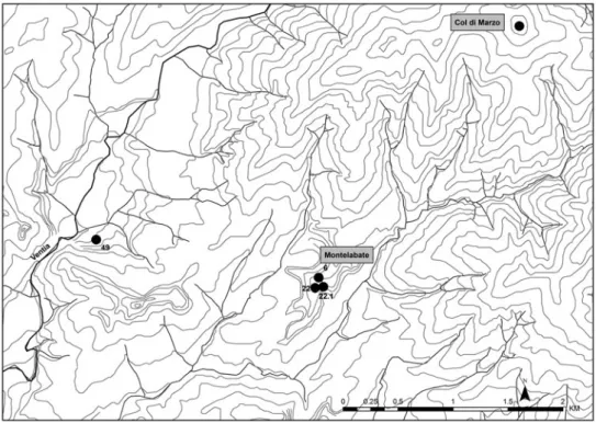
protected at the outer limit of their territory by the naturally defended farmstead of Col di Marzo. The immediate environs of the ancient abbey of Montelabate have been studied intensively by targeted, systematic and geophysical survey in conjunction with excavation, work that is still in progress. An overview of the development of the frontier is presented here, employing the data currently available.
La frontiera tra Gubbio (antica Umbria) e Perugia (antica Etruria), nella parte nordorientale della moderna Umbria, è stata fondata nel tardo VI secolo a.C. La frontiera resistette in forme diverse, più significativamente nei periodi tardo-antico e medievale, altrettanto fugacemente nel 1944, ed è fossilizzata oggi nei locali confini amministrativi. L’evidenza archeologica, documentaria e filologica sono messe insieme per analizzare differenti scale di periodo che variano da millenni ai singoli giorni nella rappresentazione di una frontiera che catturava uno spartiacque di origini geologiche. La fondazione della frontiera appare essere stata il risultato di una mediazione attiva degli Etruschi, che proiettavano nuovi insediamenti attraverso il Tevere nel corso del VI secolo a.C., protetti verso i limiti più esterni del loro territorio dalla fattoria naturalmente difesa di Col di Marzo. Gli immediati dintorni dell’antica abbazia di Montelabate sono stati studiati intensivamente da una ricognizione mirata, sistematica e geofisica, unitamente ad uno scavo, tuttora in corso. Qui viene presentato uno sguardo sullo sviluppo della frontiera, includendo i dati attualmente disponibili.
INTRODUCTION
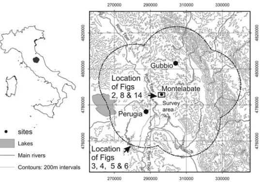
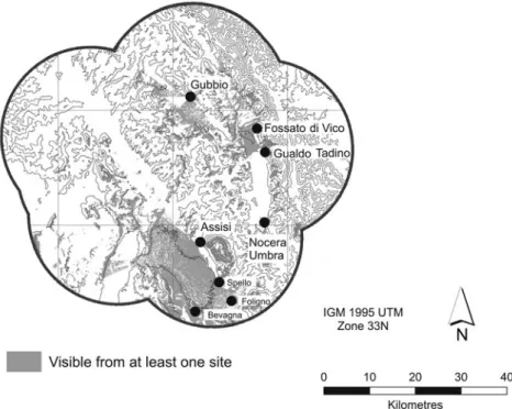
This paper analyses the Gubbio–Perugia frontier (Fig. 1), located in the northeast of modern Umbria, which captured the local physiognomy of the landscape in the late sixth century BC, and which endures to the present day. The study of the Papers of the British School at Rome80 (2012), pp. 257–94 © British School at Rome
frontier is not a new concept for archaeologists, geographers and historians (Lightfoot and Martinez, 1995; Rousselle, 1995; Stazio and Ceccoli, 1999; Zanini, 2000; Sodini, 2001; Schofield et al., 2002; Abulafia and Berend, 2002; Pastore, 2007; Pohl, 2011). However, the approach taken here goes further, in the light of the fact that modern frontiers have been much studied by anthropologists in terms of their fluidity, permeability, multivocality, ambivalence and contestation (Wilson and Donnan, 1998; Donnan and Wilson, 1999). These new approaches have studied the historical flux, derived from a mix of local autonomy at the frontier and power at the centre, but have avoided the preoccupation with modernist boundary definition and dispute. Can these same issues be played back onto the pre-modern past? The paper applies recent understanding of frontiers principally to the historical case of the Etruscans and their relationship to the Umbrians, in a geographical sector that has been well studied recently, at both a general and specific level. Moreover, the formation of this frontier in the late sixth century BC had profound longue
durée effects on the location of the frontier in all subsequent periods, most notably granting to modern Gubbio one of the largest communal boundaries of any city of comparable size in the modern period (Desplanques, 1969).
The work builds on broader long-standing study of Etruria (Stoddart, 1987; Stoddart, 1990; Cifani, 2003) and critique of dynamic frontiers (Redhouse and Stoddart, 2011) that has moved away from a modernist approach, whilst still incorporating a quantitative as well as qualitative analysis. Furthermore, there is
Fig. 1. Location of the study area in which the frontier is situated. (David Redhouse.) SIMON STODDART ET AL. 258
now a good level of understanding of the main power centres of this part of the Umbrian region, namely Perugia and Gubbio, from intensive original fieldwork (Malone and Stoddart, 1994c; Manconi, 2008), its further interpretation (Sisani, 2001) and interrogation of the accumulated archives of material from areas where systematic fieldwork has not been undertaken (Bonomi Ponzi, 2002b; Maggiani, 2002; Nati, 2008).
Specific study has been undertaken both by the current team around the ancient abbey of Santa Maria di Valdiponte (Montelabate) and the probable late Etruscan settlement of Civitella Benazzone (Sisani, 2008: 54) and by Italian colleagues around the comparable Etruscan settlement of Civitella d’Arna (Donnini and Bonci, 2008a). These results can be situated effectively within the general studies of the frontier in this region for the period of foundation (Sisani, 2008), and enlarge, contribute, as well as substantially confirm, initial conclusions.
The current article provides a provisional analysis of the dynamics of this frontier after one main excavation season and three phases of surface survey (a detailed list of participants being given in the acknowledgements), setting the scene of the main questions and answers. It is not the place to describe in detail the methodology of the survey or excavation, but briefly the survey methodology combined the best of targeted topography survey (principally led by Gabriele Cifani) and systematic field by field survey of accessible ground (principally led by Simon Stoddart), mainly to the south and southwest of the abbey in the middle reaches of the Ventia river valley, where land use is more forgiving. This methodology thus has combined both lowland and upland investigation, in spite of the difficulties of studying the wooded upland terrain. This was integrated with geophysical survey (magnetometer survey of five sites to date, one Etruscan, three Roman and one prehistoric; metal-detecting of one Etruscan site (in direct conjunction with excavation); and georadar survey of two sites to date, one Etruscan and one Roman). Finally, excavation of one Etruscan site, Col di Marzo, has commenced (under the principal direction of Caroline Malone with Simon Stoddart). Documentary data have been collected also (for the Umbrian language by Alex Mullen and James Clackson, for the medieval period coordinated by Gabriele Cifani, and for 1944 by Simon Stoddart). The use of digital recovery of data in a Geographical Information System (GIS) format has permitted the immediate release of the information so far recovered in a systematic format, and this will continue to be employed to integrate different scales of spatial and chronological data.
The detailed study area around Montelabate comprises the catchments of a series of tributaries of the Tiber (most notably the Ventia) running southwest down from the largely wooded high ground of sandstone interbedded with marl geology that forms the frontier between Gubbio and Perugia, as well as the watershed between the major rivers flowing into the Tiber. The tributaries to the southwest of this frontier descend through clay and pebble lacustrine deposits of probable Plio-Pleistocene date (derived from the ancient Tiber basin) and then through younger fluviolacustrine terraces as the Tiber itself is
approached. The archaeological finds so far encountered on these deposits (see below) broadly seem to confirm their date (Perno, 1969; Tosti and Natali, 2009).
BEFORE THE FRONTIER: PREHISTORY
The longest period of human occupation took place before the frontier developed in the last centuriesBC(Stoddart, Ceccarelli and Redhouse, in press). Work during
the survey uncovered on the early lacustrine and fluvial deposits a scatter of potential palaeolithic material, defined as such on the basis of comparison with material discovered in the Gubbio area (Reynolds, 1994). In contrast to the Gubbio area and other parts of the nearby main Tiber basin (such as the discovery of upper palaeolithic material in the lower Chiascio: Bellucci, 1915; Donnini and Bonci, 2008b: 147), there are no substantial concentrations of material from this early period in the environs of Montelabate, although there is a number of locations in the upper part of the landscape with higher densities than single finds. The situation changes in the Neolithic/Bronze Age (Fig. 2), since for this period two concentrations were found in the lower part of the landscape, the first on a lower terrace of the Ventia river (79) and the second at slightly higher elevation near a spring (48). Both are broadly
Fig. 2. Distribution of the main concentrations of prehistoric material. The river Ventia flows into the Tiber to the south. The locations of Col di Marzo and
Montelabate (not occupied in this period) are shown. (Letizia Ceccarelli.)
SIMON STODDART ET AL. 260
characterized by small numbers of bladelets and flakelets accompanied by meagre amounts of prehistoric pottery (including at least one upright rim and an a squame (scale decoration) fragment) and occasional evidence of organic staining of the sediments.
By the end of the second millenniumBC, the most prominent phenomenon of
the region is the presence of middens (Fig. 3) on the crests of the main limestone escarpments above Gubbio (Malone and Stoddart, 1994a), Perugia (Matteini Chiari and Mattacchioni, 2008) and Umbertide (Cenciaioli, 1992). These are best interpreted as feasting deposits, on the basis of the quantity and profile of the ceramic and faunal material. Moreover, they are clearly intervisible over a landscape still without formal frontiers. The main controversy is over the rituality of these upland sites (Stoddart, 2012) and their relationship to more poorly known lowland settlements. The best progress has been made at Gubbio, where both upland and lowland sites have been investigated, and form a collective system of sites within a relatively small
Fig. 3. The location of the main final bronze age sites in the region, showing the importance of intervisibility between them. (David Redhouse.)
horizontal distance; but the issue is clouded by a purported relationship to the ritual of the Iguvine Tables (Ancillotti and Cerri, 1996; Sisani, 2001). Perugia provides a case of an apparently lower altitude occupation in the same period, although the location (via Settevalli) is in the suburbs and not in the upper levels of the town (Bonomi Ponzi, 2002b) where, because of the modern city, it has been difficult to establish the true extension of the settlement.
FOUNDING THE FRONTIER: THE LAST MILLENNIUM BC
In the first half of the last millennium BC, population consolidated around the
centres of Gubbio and Perugia, moving down from the previously occupied upland locations, thereby drastically changing the viewsheds calculated from areas of habitation. New discoveries at Gubbio demonstrate clearly that a population centre of some 34 ha developed principally on the right bank of the Camignano river between the eighth and fifth centuries BC, with associated
cemeteries (similar to those found in the Marche) in the San Biagio area to the south (Manconi, 2008; Manconi, pers. comm. 2009). There are also traces of settlement further east on the flanks of Monte Ansciano (Malone and Stoddart, 1994b) and possibly subsidiary settlements at Torre Calzolari and Branca (Stoddart and Whitley, 1994), an area of potential political vacuum where a boundary might have emerged between Gualdo (another early centre) and Gubbio. An accumulation of discoveries in Perugia has shown clearly a widespread Villanovan occupation of the city. These finds occur in a number of locations, indicating a sizeable nucleation of population — not unlike the size of the modern historic centre —, surrounded by cemeteries at a distance of 500–1,000 m, with satellite villages towards the major Etruscan and Umbrian centres (Bonomi Ponzi, 2002b: 588). This latter distribution of smaller centres, probably politically associated with Perugia, contrasts with the situation in Gubbio, whose community, as can be seen also below in the analysis of the Iguvine Tables, was more preoccupied with the city limits than the more distant political boundaries. We cannot know whether this perception of the political landscape was shared by other Umbrian communities in the absence of documentation as elaborate as the Iguvine Tables.
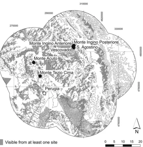
The conceptual vision of the territory was maintained by the panoramic viewsheds of the sanctuaries that were founded principally in the sixth century
BC on and near the crests of the Umbrian landscape (Fig. 4). In the case of
Gubbio much has been made by some (Ancillotti and Cerri, 1996; Sisani, 2001) of the stratigraphic relationship between bronze age feasting deposits and superimposed depositions of schematic figurines (after an apparent hiatus of hundreds of years). This superimposition also occurs at Monte Acuto (Cenciaioli, 1996) and Col di Mori (Stefani, 1935; Bonomi Ponzi, 2002a) (Fig. 4). In the case of Monte Tezio, the sanctuary is not located at the same altitude but offset to the east (Colonna, 2009), permitting a panorama over
SIMON STODDART ET AL. 262
many of the other Umbrian sanctuaries of the period. If we can equate this cumulative panorama with a shared identity, then it appears that the frontier was not formed by this period (see also below for complementary evidence), but that communities still considered themselves interconnected and not distinct. The distribution of types of figurines across the landscape also shows the permeability of ritualized material culture, cutting across the divisions that later became Etruscan and Umbrian (Stoddart, Stevenson and Burn, in press). Indeed, the discovery of two figurines similar in style to those from both the future Etruscan and Umbrian areas during the 2011 excavation of Col di Marzo emphasizes the interconnectedness of a landscape without distinct frontiers.
The frontier appears to have crystalized only towards the very end of the sixth century BC in the Montelabate area. Its construction seems to have been
substantially an Etruscan initiative in a number of locations north of Perugia (Berichillo, 2004: 179–84; Nati, 2008), following a pattern coinciding with the
Fig. 4. The location of the main Archaic sanctuary sites in the region, showing the importance of intervisibility between them. (David Redhouse.)
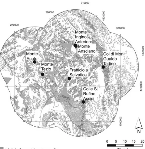
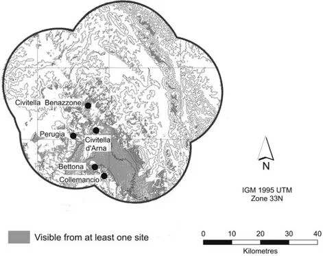
limits of visibility from Perugia (Fig. 5). The initiative also incorporated the viewshed of sanctuaries near to Perugia (but not those focused on Gubbio and Gualdo Tadino). When the Etruscan viewshed (Fig. 5) is combined with the viewshed from the immediately opposing Umbrian centres (Gubbio, Fossato di Vico and Gualdo) (Fig. 6) a considerable expanse of dead ground is left in the intervening mountainous area. In detail, the development of the frontier involved the following actions. Firstly, flanking the detailed survey area, two larger settlements accompanied by Etruscan inscriptions appear to have been projected across the Tiber: Civitella Benazzone (Sisani, 2008: 53–4) and Civitella d’Arna (Sisani, 2008: 54). These are both topographically distinctive urban locations (as suggested by the term Civitella) that command their local micro-regions, including the tributaries of the Tiber (Resina and Ventia; Chiascio) that drain the southern flanks of the higher ground between Gubbio and Perugia. Secondly, at least one smaller defended farmstead (Col di Marzo) (see below) (Fig. 7) seems to have been projected towards Gubbio at the limits of visibility from Perugia, Civitella Benazzone and Civitella d’Arna. Thirdly, rural settlement seems to have infiltrated at a much slower rate between these topographically distinct locations (Fig. 8), only taking proper hold in the full Roman period (below, Fig. 14), once the frontier had been absorbed into higher order administrative structures. Even though this frontier lasted only about 200 years, it did not disappear from the conceptual landscape, since this frontier of varying degrees of consolidation remained in place right up to the present day
Fig. 5. The vision of the Etruscans. Viewsheds from a selection of settlement sites that might be expected to have had Etruscan identity. (David Redhouse.)
SIMON STODDART ET AL. 264
(see below, p. 285). A similar political strategy also appears to have extended further south to Brufa to the south (Sisani, 2008: 54–5) and to Solfagnano to the north (Dareggi, 1972: 389, 396; Cenciaioli, 2008). Still further south, the frontier was probably more ambiguous and contested since the ‘Etruscan’ vision of Perugia, Bettona and Collemancio over the Valle Umbra overlapped considerably with the ‘Umbrian’ vision (Fig. 6) from Assisi, Spello, Foligno and Bevagna. Dead ground was replaced by ground within sight of both sets of communities.
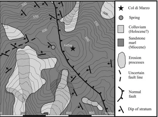
A different scale of detail is provided by the examination of Col di Marzo, a circular, sandstone hill (645 metres above sea level), with a flat terrace to the northwest. Various phases of topographic survey (Fig. 9) have defined an upper rounded eminence above a naturally defended substantially flat area of about one ha, extending to the southeast, with a possible entrance to the west. The hill is currently under pasture, small oaks and black thorn scrub. The underlying stratigraphy has proved to be still reasonably well preserved, even though there is some local evidence of erosion on the steeper slopes and ploughing recalled in local memory, which has brought tile and building stone to the surface and led to the construction of some clearance piles.
This location epitomizes the enduring quality of the frontier since it has a substantial, although not flawless, panorama of the local landscape, is the nodal point of a number of significant roads of different periods (Pinder and
Fig. 6. The vision of the Umbrians. Viewsheds from a selection of settlement sites that might be expected to have had Umbrian identity. (David Redhouse.)
Parthey, 1860: 273, 478; Matteini Chiari, 1975: 18, n. 75; Cavallo, 2004; Sisani, 2007: 117; Berichillo, 2009: 67–90) that interlink to Perugia (Grohmann, 1981: 649–66; Colonna 2009: 250), Gubbio (Sisani, 2001: 33–7, 39–42) and the Adriatic (Luni, 1996) and lies astride the modern boundary between Gubbio and Perugia. In addition, there is a modern spring located some 200 m to the west of the summit (Fig. 10). A normal fault runs north-northwest– south-southeast to the west of the site, contributing to the defensive topography of the west side of the hill and recalling the active tectonics of the area (Tosti and Natali, 2009).
More detailed evidence has been provided by the August 2011 excavations of Col di Marzo (Fig. 9). These have dated the occupation securely to the late sixth centuryBC, accompanied by unusual preservation under collapsed and burnt tiled
structures, sealing rich information on economics (subsistence and production) and ritual. The recovered data suggest that the small population of this frontier
Fig. 7. The fortified farmstead of Col di Marzo on the frontier between Gubbio and Perugia. (David Redhouse.)
SIMON STODDART ET AL. 266
site were engaged in self-sufficient grain and wine production and in artisan activity (for example, metal- and horn-working) in a naturally defended location that was strengthened by the construction of banks, ditches and terracing.
THE SITE OF COL DI MARZO (GC)
Col di Marzo has a circular shape, flanked on the northwest side by a huge flat terrace; the top of the hill is roughly flat and it can be described as a rocky circular platform set within a naturally defended circular area of about 1 ha. On the top of the hill we can distinguish a flat sector on the southeast side and a more elevated area on the northwestern side. A spring is located about 200 m west from the top of the hill, at the bottom of the slope, along the 600 m contour. The hill is located in a seismic area, precisely along a fault line that runs across its southern and western slopes (Tosti and Natali, 2009) (Fig. 10). At the present time the site is not cultivated, but it is used sporadically for grazing sheep; it is covered mainly by young oaks and bushes; the top of the hill is affected by soil erosion, above all on the steeper southern slope.
Col di Marzo was identified for the first time as a‘castelliere’ in the mid-1970s by Matteini Chiari (1975: 18, n. 75; 1980: 220, tav. XV, 2–4) among the pre-Roman settlements between Gubbio and Perugia. In fact, the place marks
Fig. 8. Late Etruscan rural sites from the detailed study area on the frontier. For the location, see Fig. 1. (Letizia Ceccarelli.)
perfectly the boundary between the two city-states, and it today lies at the administrative border between the modern city councils. In antiquity, the site controlled a crucial network of roads between Perugia and Gubbio, and particularly the short-cut from the Tiber valley, from the area of Ponte Pattoli, along the Ventia valley toward Gubbio, where the road from the south is marked by the location of the necropolis of Vittorina (Sisani, 2001: 35–7, 39–42), which was in use from the end of the fifth century BC (Matteini Chiari,
1975: 18, n. 75; Colonna, 2009). Grohmann (1981: 649–66) discussed the road system in the fifteenth century.
This route can be considered the easiest and the fastest to link Perusia with Iguvinum, and both cities, according to the anonymous author of the Cosmographia Ravennatis, were linked by the Via Amerina, the Roman road that started from Veii or Nepi (Pinder and Parthey, 1860: 273, 478; Cavallo, 2004; Sisani, 2007: 117; Berichillo, 2009). The site of Col di Marzo also had
Fig. 9. Excavation and geophysics areas on Col di Marzo. (David Redhouse.)
SIMON STODDART ET AL. 268
visual control of the area of Belvedere, from where a road system started towards the east, reaching the site of Gualdo Tadino and from there other areas in the direction of the Adriatic coast (Luni, 1996).
The presence of a pre-Roman settlement seems to characterize at least the upper terrace of the hill; this area was fortified not only by the cliffs themselves (which were steepened artificially), but also by an earthwork faced by walls made of irregular blocks of the local stone, which are still visible mainly on the southern and eastern sides of the hill (Fig. 11). A possible entrance to the settlement was on the west side, where the slope appears less steep. The upper plateau is characterized by a series of mounds, fragments of red tiles and dolia, which might indicate the presence of ancient buildings. Some material collected mainly from the southern slope of the hill contributes to a preliminary chronology of this site within the pre-Roman period, since three rim fragments of local grey bucchero hemispherical bowls find comparisons with similar items found in funerary contexts from the fifth to the third centuries BC (Bonomi
Ponzi, 1997: 136, tav. 62, 12.5, 12.6; Tamburini, 2004: 189) and ceramica ad impasto buccheroide from excavations in Gubbio (Manconi, 2008: 72–4). The fortified settlement at Col di Marzo can be considered to lie amongst frontier sites of the territory belonging to the Etruscan city of Perusia (Berichillo, 2004: 179–84; Nati, 2008); among these we can quote the sanctuaries (and settlements) of Monte Acuto, Pasticcetto di Magione, Colle Arsiccio, Civitella
Fig. 10. The geological environs of Col di Marzo. (Adapted by Simon Stoddart from Tosti and Natali, 2009.)
d’Arna, Mandoleto, Bettona and Monte Tezio (Berichillo, 2004: 197; Colonna, 2009). Monte Acuto and Monte Tezio can be compared to the morphology of the settlement of Col di Marzo, being located on the top of mountains and fortified by a circle of walls; in addition, the chronology of their use (since the latest phases of the Bronze Age and the Archaic phase onward) may suggest an earlier chronology also for the site of Col di Marzo.
IMAGINING THE FRONTIER? THE ROLE OF THE IGUVINE TABLES FROM GUBBIO
The Iguvine Tables, dating from the third to first centuries BC, are a unique
survival from the ancient world. No surviving text from anywhere else in Italy compares. The tables have been the object of scholarly study for centuries, and since the work of Aufrecht and Kirchhoff (1849–51) there has been general agreement about their structure and purpose. Scholarly differences remain,
Fig. 11. The southern‘defences’ of Col di Marzo. (Gabriele Cifani.)
SIMON STODDART ET AL. 270
however, particularly as regards the interpretation of individual words and phrases. In recent years, there has been debate about the subject under investigation in the current project, namely whether the tables can inform us about the boundaries of ancient Iguvinum.
Two passages are of potential importance for this issue. Both occur within the longest section describing the ritual purification of the city and the lustration of the people. (The purification ritual occupies VIa1–VIb47 and exists in a short version at Ia1–Ib9; the lustration is described in the short version at Ib10–45, and a longer one at VIb48–VIIa54.) The first passage of interest occurs in the long version of the purification ritual on Table VIa, one of the sections written in the Roman alphabet and dating to the second or first century BC. In the
course of the preparation for the ritual, the tablets describe the ritual taking of auguries. This involves two participants, the augur and the officiating magistrate, arsfertur in Umbrian. The tablet describes when the observation takes place and marks out the sacral area. In this passage a short section appears headed toderor totcor, which is usually translated as ‘public boundaries’ or ‘city boundaries’. These are then described from the point of view of the augur sitting in the lapides augurales. Boundary points are listed, each with a directional marker indicating motion ‘towards’ and some with a following dependent genitive.
The exact meanings of these boundary points and dependent genitives have been debated, with some scholars pushing the interpretations to their limits. Ancillotti and Cerri (1996), for example, gave a translation of VIa12–14 (reproduced in Table 1), identifying a range of geographical features, buildings and places, which they subsequently assigned to locations in ancient Iguvinum (Fig. 12). Ancillotti and Cerri’s translation, and their mapping of particular points of the townscape of Iguvinum, has attracted a fair amount of scepticism from the scholarly community (compare, for example, the entries for the individual words discussed by Untermann (2000)).
Recently, Sisani has rejected Ancillotti and Cerri’s interpretation and proposes a radically new one (Sisani, 2009; cf. Sisani, 2001). His interpretation is based on the context in which the description of the boundaries is found, namely the interpretation of the flight of birds from the augural rocks. Sisani proposes that the boundaries are not those of terrestrial space, but an area in the sky, a celestial sacred space. The points are therefore marks occurring across the vision of the augural priest (Fig. 13).
The German scholar Rix (2009) is critical of Sisani’s idea of a ‘temple in the sky’ in a posthumously published text. Rix calls into question the usual interpretation of the opening Umbrian phrase, toderor totcor. Rix was of the opinion that this does not refer to city boundaries, but publicly agreed limitations to the line of sight of the augur and the augur’s position across the Umbrian plain. In Rix’s interpretations, ‘commonly agreed limitations’ might be a better translation.
We therefore are faced with three very different interpretations of this short passage. Following the lead of more cautious scholars (such as Untermann
(2000) and Rix (2009)), we suggest that the only plausible interpretation of any of these lexical items is tettom ‘roof’, based on comparison with Latin tectum, although even this is not certain (cf. Weiss, 2010: 150, n. 56). We can suggest etymologies and comparanda for the other lexemes endlessly, but must admit that this is mostly a futile exercise. Our tentative interpretation (Table 2) leaves most of the words untranslated (in italics).
Our general inability to understand this section of text in its details means that its relevance for the current project on the frontier is limited. Nevertheless, some important issues arise. The list of markers does not seem to contain any Umbrian words for peaks, ridges, hills, rivers and so on, but rather seems to focus on the urban setting, presumably within the confines of ancient Iguvinum (based on the only likely interpreted word in the section, tettom ‘roof’, and the range of interpretations offered for the remaining words). It therefore cannot help us in establishing the nature and position of the wider frontiers and boundaries that may have marked out the broader territory. Despite numerous difficulties in understanding the whole text engraved on the Iguvine Tables, we are sure that its main function is in prescribing ritual acts. These records presumably were of significance to a group of people that may have consisted of anything from a small group of initiates to the entire community at Iguvinum. In this context it is perhaps not too surprising that they were not interested in setting out in Table 1. Transliteration and translation of the text from Table VIa following Ancillotti and Cerri (1996: 299).
tuderor totcor: E questi sono i confini della città: (a partire dal punto dei
confini) all’altezza delle rocce augurali nella direzione delle porte, al ponte, ai cortili di Norbio, alla curva del fiume, alla palude, al tetto della famiglia Miletina, fino al terzo dei terrapieni di prosciugamento. Sempre dal punto all’altezza della rocce augurali, alla grotta del dio Vesticio, al loggiato di Rufro, al tetto della famiglia Nonia, al tetto di Salio, alla grotta del dio Hoio, al passaggio sacro alle divinità dei transiti.
Uapersusto auieclir ebetrafe ooserclome
presoliafe nurpier uasirslome smursime
tettome miletinar
tertiame praco pracatarum Uapersusto auieclir carsome uestisier randeme rufrer tettome noniar tettome salier carsome hoier pertome padellar
SIMON STODDART ET AL. 272
detail the boundaries of their territory, as that information presumably would have been established within the community.
One other, much longer, section in the tablets may take us a little further. Within the section dealing specifically with the lustration, the officiating priest is instructed to go to a certain point in the city and then pronounce the expulsion of various alien peoples, named in turn. (The names exist in both the
Fig. 12. Plan of the ancient city of Iguvinum. (Adapted by Simon Stoddart from Ancillotti and Cerri, 1996: fig. 49.)
short version at Ib17–18 and are repeated several times in the long version on Tables VI and VII.)
short version (native Umbrian Script): tuta tarˇinate, trifu tarˇinate, turskum, naharkum numem, iapuzkum numem
long version (Latin script): totam tarsinatem, trifo tarsinatem, tu(r)scom naharcom iabuscom nome
translation: The community of Tadinom, the tribe of Tadinom, the Etruscan, the Naharcan name, the Iapydic name.
Whilst frontiers are still not described, here is a list of the‘others’ who existed beyond the boundaries. We can identify one of these ancient communities and position it geographically: tuta tarˇinate/totam tarsinatem refers to the people of ancient Tadinum, now located in modern Gualdo Tadino, 25 km to the southeast of Gubbio. The ethnic naharkum/naharcom is doubtless linked to the people round the river Nar in southern Umbria (note the ancient name of Terni, Interamna Nahars); turskom/tu(r)scom refers to the Etruscans; and the name iapuzkum/iabuscom probably is to be identified with the Greek ethnic label Iapydes, located by other ancient sources on the opposite side of the Adriatic. These names provide us with some important evidence to factor into the overall picture of the mutable and transformational frontiers and interacting communities of this area, but the impossibility of specifying locations more exactly using the epigraphic evidence is frustrating. What is perhaps significant,
Fig. 13. Skyline with the interpretation following Sisani (2009: 183), with additions for orientation. (Simon Stoddart.)
SIMON STODDART ET AL. 274
however, is that Rome does not feature in this list of names or, in fact, at all in these tablets. Yet the act of recording in bronze may well be a result of contact with Roman practice, and the later part of Table Vb and Tables VI and VII use the Latin alphabet. We could theorize that the increased interest in specifying, recording and preserving ritual acts, which were seen as essential in the formation of an urban identity and history for Iguvinum, was one response to the wider political concerns of the time and a reaction to the increasing power of Rome. Rome is not mentioned as an enemy, but nor are Iguvine rituals in any way explicitly linked to Rome. Iguvinum may be creating its own identity and keeping its relationship with Rome ambiguous and open to negotiation.
ABSORBING THE FRONTIER: THE ROMAN EMPIRE
In the course of the third centuryBC, our frontier zone was drawn into the Roman
political orbit, even if (see above) the citizens of Iguvinum chose not to mention the Roman presence. Significant events include the Battle of Sentinum of 295BC,
the foundation of the colony of Rimini in 268 BC and the construction of the
Via Flaminia in 220 BC (Harris, 1971; Stoddart, 1994: 176). The conclusive
Table 2. The interpretation of Table VIa (by Clackson and Mullen).
Umbrian Tentative interpretation
tuderor totcor: Urban / publically agreed boundaries
Uapersusto auieclir from the augural rocks
ebetrafe to the ebetraf
ooserclome to the ooserclom
presoliafe nurpier to the presoliaf of Nurbis
uasirslome to the uasirslom
smursime to the smursim
tettome miletinar to the roof of Miletina
tertiame praco pracatarum to the third praco pracatarum
uapersusto auieclir from the augural rocks
carsome uestisier to the carsom of Vesticis
randeme rufrer to the randem of Rufer
tettome noniar to the roof of Nonia
tettome salier to the roof of Salis
carsome hoier to the carsom of Hois
pertome padellar to the pertom of Padella
absorption of the frontier within the administrative apparatus of Rome dissolved aspects of the formality of the frontier, but did not completely dismantle its memory or even its administrative existence, since it was revived (see below, pp. 280–2) in the early Middle Ages, when political control once again was downscaled. In any case, Roman political strategies generally operated through preceding political organization, rather than running against the grain of the pre-existing political structure. The area became well networked into the local and international economy, employing the Tiber valley as a key communication conduit. The local clays were employed extensively to produce amphorae and coarse-wares, and a reverse trade with locations as distant as north Africa can be detected amongst the pottery.
The spatial patterning of the frontier region was changed substantially. Rural settlement infilled the area (Fig. 14), distributed both in the lower sandstone interbedded with marl foothills between 250 and 300 m above sea level, on the Pliocene lacustrine sediments and on the terraces of the Tiber tributaries. In common with many areas of central Italy, a demographic peak was reached in the early Imperial period. There was also some continued presence into the later Roman period, on a scale apparently greater than that encountered in the Gubbio valley (Whitehead, 1994), although redating of the Gubbio material with new information on amphorae may now minimize these differences. The evidence of the agricultural exploitation and the production of wine in the area is documented by site 6 (Figs 14 and 15), where a kiln already known from
Fig. 14. Roman rural settlement in the Montelabate area. (Letizia Ceccarelli.)
SIMON STODDART ET AL. 276
previous research (Cenciaioli, 1984; 1985) has now been studied in more detail. Initial magnetometer study of the site has shown that subsurface structures (identifiable as five magnetometer peaks) most probably survive even in this heavily worked modern agricultural landscape (Fig. 16).
The kiln produced a type of flat-bottomed amphorae known as ‘Spello amphorae’ or Ostia III, 369/70 (Panella, 1989: 143–6). These small wine amphorae were produced from the Tiberian-Claudian period until the end of the second century AD, and were used for the transport of wine. The Hirtiola
wine, as mentioned by Pliny (Naturalis Historia 14.37), was exported from the upper Tiber valley to Rome, the largest market, and Ostia, although there is also evidence for local distribution as noted at Scoppieto (Speranza, 2011: 286). In Rome, this type of amphorae represented the largest Italian production after the Dressel 2–4 from the Flavian period (Bertoldi, 2011: 150). On the basis of the collected fragments (Fig. 17), there was little standardization, as the rims were both almond-shaped (type 2.6 of Lapadula’s typology (1997)) and ring-shaped (type 4.10; also documented at the Villa of Pliny at San Giustino, defined as Altotiberina 1; see Molina Vidal, 2008). The kiln was used also to produce tiles and coarse-ware, providing evidence for a villa production system, where both wine and the vessels to hold it were made as part of the same commercial productive process. Moreover, it also offers evidence for another production centre on the eastern bank of the river Tiber.
Local identity was sufficient also to involve the presence of small rural cemeteries (Cenciaioli, 1986) that were separate from those associated with small local urban centres. Both the rural settlement and the tombs continued into the later Roman period, although subject to a relative decline and probable contraction of population in common with other areas of central Italy. The late Roman occupation is documented by local production and imported material, such as the small amphorae type Keay XXVI, dated to the fifth century AD
(Keay, 1984: 145).
The pattern for the Montelabate area appears to be typical of the frontier region more generally. In the territory of Civitella d’Arna to the south there is
Fig. 15. The subsurface structure revealed by magnetometer survey of an early Imperial Roman rural farmstead in the Montelabate area (site 6). (David Redhouse.)
the same relative absence of rural settlement until the very last centuriesBC, with a
peak in the early Imperial period. The researchers in the area have suggested that after the Bellum Perusinum (41–40 BC) and other progressive weakening of
Perugia’s political control on local settlement, administrative control of this area to the south may have been reallocated to the colony of Spello (Hispellum) (Donnini and Bonci, 2008b), and it is conceivable that economic networks (such as pottery production) may have been redirected at the same time. Data
Fig. 16. Evidence for ceramic production. High magnetometer readings (black) of probable kiln structures at Site 6. (David Redhouse.)
Fig. 17. Amphorae from Site 6. (Drawn and identified by Letizia Ceccarelli.)
SIMON STODDART ET AL. 278
from the area to the north have not been synthesized, but preliminary indications from rescue excavations by the Superintendency (Ministero per i Beni Culturali e Ambientali, Soprintendenza Archeologica per l’Umbria, 1983; Cenciaioli, 2008) and the more extensive excavation of at least one Imperial villa (Cappelletti, 1998) suggest a broadly similar picture.
REASSERTING THE FRONTIER: LATE ANTIQUITY
During the Byzantine period, the frontier zone was located at an important juncture on the corridor between Rome and Ravenna (Fig. 18), a historical circumstance that added another dimension to the complexity of frontier development (Partner, 1972: 3; Menestò, 1999). In this case the frontier became linear, operating on two fronts at right angles to its original direction, requiring the control of a series of strong points, castra or ‘strategic hamlets’ (Brown, 1978), to maintain communication between key points in the surviving empire in the West. Perugia, in particular, had a crucial role during the events of the Greek–Gothic war (AD 535–54) (Bocci, 1997). From AD570 to 774 the territory
between Perugia and Gubbio became one of the most contested frontier areas in the Mediterranean, since it was set pivotally in the narrow tract of territory that linked Rome to the Byzantine Exarchate of Ravenna along the Via Amerina (Zanini, 1998: 246; De Santis, 1999; Brown, 2008; McCormick, 2008). Two Lombard Duchies, Spoleto to the east and Tuscia to the west, pressed each side (Riganelli, 1994; Carile, 1999; Riganelli, 1999). This led to a tenuous political control of both nodal points such as Perugia (Zanini, 1998: 138–41) and the territorial borders, containing a strip of Byzantine territory as narrow as 2–10 km (Del Lungo, 1999), focused on what is now the modern road to Gubbio. Consequently, there was frequent military action, including the temporary Lombard conquest of Ravenna between 751 and 756 by King Astulf (Cosentino, 2008).
The strategy of maintaining the urban status of both Gubbio (Lanzoni, 1923; Matteini Chiari, 1995: 410–14, nn. 617–21) and Perugia (Lanzoni, 1923: 350–3; Castellani, 1996; Castellani, 1998; Bisconti, 2005; D’Acunto, 2005; Del Lungo, 2005; Fonseca, 2005; Palombaro, 2005; Pani, 2005; Scortecci, 2005; Sisani, 2005; Vagni, 2009) was crucial in these circumstances, and, in spite of the limited archaeological evidence, this appears to have been successful. There is an equal lack of knowledge of the countryside, but we can surmise that castra also served to protect the sourcing of food for the city. This understanding runs in agreement with work by Francovich (2002) and Moreland (2010: 147–58), whose work has concentrated on Tuscany and Lazio respectively. Systematic targeted survey and excavation as undertaken by these scholars may be able to prove that the pattern identified by them extended to this strategic zone of Umbria.
DOWNSCALING THE FRONTIER: THE MIDDLE AGES
The 817 treaty between Pope Paschal I and the Franks was ‘the first well-authenticated document to define the temporal power of the popes’ (Partner, 1972: 47), and the ‘Byzantine’ Perugia frontier was implicit in this understanding, where jurisdiction had been handed on to papal authority.
Fig. 18. The Byzantine‘corridor’ prior toAD751. (Adapted by Simon Stoddart from
Zanini, 1998: combining fig. 10 (p. 101) with fig. 79 (p. 263).)
SIMON STODDART ET AL. 280
However, in practice throughout the medieval period the Perugia population manipulated their strategic position between the Franks, or their successors from the north such as the Visconti, and the papacy to their own political ends or even for safety (Partner, 1972: 242, 356). For instance, in the thirteenth century, Gregory IX, even though often forced to be resident in Perugia, found that the political authorities did not always set up alliances of his liking (Partner, 1972: 252). In the late fourteenth century, Boniface IX was forced to permit the Visconti to hold the city (Partner, 1972: 382), albeit temporarily, even though not officially yielding political authority. A stronger papal position in Perugia was established from 1424, when it became a large and rich focus of financial support (Partner, 1972: 403, 430–1).
In the tenth century, and possibly earlier, the specific frontier zone between Perugia and Gubbio was reoccupied slowly through the process of incastellamento, common to other parts of the Tiber valley and central Italy more widely (Tiberini, 1999: 179; Benni, 2006). In the northwest of our area of the frontier, this process was centred on Civitella Benazzone, previously known as mons Martelli, and fortification here can be dated to at least 1068, and most probably to 995 (Luttrell, Adams and Toker, 1972: 150). A comparable colonization of the area by local landed aristocracy can be proposed around the similar centre of Civitella d’Arna to the southeast of our study region.
The frontier zone between Perugia and Gubbio, coinciding with the border of the dioceses of the two cities (Banti, 1936; Cenciaioli, 2005), was filled also with spiritual authority. The Benedictine abbey of Santa Maria di Val di Ponte was founded by at least 995 (De Donato, 1962: 4–7, n. 2; Becchetti, 1997). The authority of the abbey in this phase (tenth–thirteenth centuries) was based on specific privileges (immunities) granted directly from the pope granting temporal autonomy separate from the local lay authorities (De Donato, 1962: 12–14, nn. 5–6). A similar privilege was offered to the church of San Pietro of Perugia (Zucchini, 2004). Its economic power was based not only on the ownership of fertile arable lands along the Tiber and its tributaries, but pre-eminently on the control of the road systems between the two cities and on the ownership of mills along the Tiber. (Sella (1952) recorded that the abbot was still able to pay the Holy See 165 pounds in 1334, a large sum for the diocese of Perugia.)
In the case of the smaller (and sometimes dependent) abbey of San Paolo di Valdiponte, it was a natural process to insert the second abbey in the shelter of the fortified point of Civitella Benazzone, but this took place only in the very early twelfth century, traditionally 28 May 1100 (Luttrell, Adams and Toker, 1972; Tiberini, 1999: 52–4), and at least by 1109 (Blagg, Blake and Luttrell, 1974).
The relationship between the component parts of this equation — temporal and spiritual authority, smaller and larger abbeys, urban centre and rural frontier, mediated through the personalities of the nobility — is the history of the region in the rest of the Middle Ages. The annalistic accounts of Santa Maria di Valdiponte reveal successful conflicts with San Paolo, other defences of the abbey’s possessions, and phases of renovation and ultimately decline (Ricci and Amatori, 1935: 267, 271, 287). These accounts also reveal the
extensive possessions of the abbey, ranging widely into the neighbouring regions of Lake Trasimene, Perugia, Gubbio and Gualdo, comprising churches, lands and castles (Tiberini, 1999: 4–12). Documents from the city of Perugia reveal, in considerable detail, the demographic and familial relationships between city centre and countryside, providing invaluable minutiae of numbers and value (Grohmann, 1981). The castles under the abbey’s control included those bounding the detailed survey area at Castelfidatto (from 1050), Montelabate and Civitella Benazzone (from 1166) (Ricci and Amatori, 1935: 308). Thus the abbey was part of an intermittently autonomous buffer zone between Gubbio and Perugia, on the Perugia side of the political frontier itself marked by the construction of series of castles that became increasingly in active use during the course of the twelfth and fifteenth centuries (Menichetti, 1979; Grohmann, 1981; Allegrucci, 1994: 207) (see, for example, Fig. 19).
THE LEGACY OF THE FRONTIER: THE MODERN PERIOD
The dissolution of the frontier between Gubbio and Perugia followed the end of the military and political independence of both city-states in favour of the rising
Fig. 19. Two castles adjoining the abbey of Santa Maria di Valdiponte (Montelabate). A. Castellaccio di Montelabate. B. Castiglion Fidatto. Heavy lines show the surviving masonry; thin lines show the probable line of the walls. (Wall
plan survey undertaken by Federico Nomi.)
SIMON STODDART ET AL. 282
power of the Church between the fifteenth and sixteenth centuries. In the fully modern period, the communal boundaries were consolidated in the same frontier area that had already been established in the medieval period, surviving collective ownership by the papal states and the Unification of Italy. After Unification, the demilitarization of the frontier became complete, but it was remilitarized fleetingly in June and July 1944 (Fig. 20).
During the Second World War, the geographical framework of the Tiber valley and the flanking mountains led to a natural funnelling of evidence of military activity (bullets and shrapnel being found during the survey) into natural access routes along the Ventia tributary towards strong points on the uplands to the north, providing natural elements of the Frieda/Albert/Trasimene line. Perugia was outflanked by Gurkhas and the North Irish Horse advancing from the east (after the capture of the Assisi airfield on 17 June 1944), heading towards the ridge of Ripa and Civitella d’Arna. At about the same time the Frontier Force secured the Belvedere ridge towards Gubbio (Hingston, 1946). This outflanking manoeuvre undoubtedly led to the withdrawal of the Germans from Perugia on the night of 20/21 June 1944 (Absalom, 2001; Ranieri, 2002; Carver, 2002: 214), and the city was entered by troops that included the famous historian E.J. Thompson (1985). The Germans were still probing south from one base at Ramazzano on 22 June, coming under direct counter-fire, as recorded in the journal of Major Georg Zellner (Holland, 2009: 229–30). His opponents probably included components of the 3rd King’s Own Hussars, who advanced ‘in a spirited tank action’ (Reid, n.d) on 23 June to secure, in bitter fighting, Piccione and Colombella, leading to the alleged destruction of 200 Germans and 1,100 guns, as well as the capture of 50 mules (Hingston, 1946).
At this point the Eighth Indian Division was relieved by the Tenth Indian Division, and because these strong points of the Tiber valley were offering strong resistance and were less suitable for tank warfare (Brooks, 1996: 55), the 6th British Armoured Division was diverted to the Battle for Lake Trasimene (Dethick, 2002), and the promise of the open country of the Val Chiana north to Arezzo and Florence (Fisher, 1977: 268–9). It was on the two sides of Lake Trasimene (and more particularly the western) that the decisive battles were fought in late June and early July 1944, permitting advance on Cortona and Arezzo. Meanwhile, progress continued in the upper Tiber valley after a five-day lull necessitated by the change of personnel harassed by the enemy. In spite of the reduced armoured support, the 10th Indian Infantry Division, relative specialists in mountain warfare, made progress up the Tiber valley past Montelabate. Reid (n.d) reported that the occupation of Colombella and Piccione was repeated without resistance on 30 June, and the 3/1 Punjab, after occupying Ramazzano, by first light on 2 July had taken hold of Civitella (Benazzone?) and Solfagnano (Sollagnano in Reid’s text). Thus the advance continued up the Ventia valley, with the Mahrattas on the Belvedere ridge above Montelabate, the Gurkhas in the centre, and the 8th Manchesters on the flank closer to the Tiber (Hingston, 1946); Montelabate and Col di Marzo are
not mentioned by name, but must have been occupied on about 2 July. An attack by an officer of the Indian army against German defenders was revealed during excavation in 2011. The date of this encounter (bracketed by documentary evidence) must again be 2 July, but the event is physically recorded only by the archaeological evidence of Smith & Wesson bullets (upslope) and cartridges (downslope), and we do not know the names of the combatants. At about the
Fig. 20. The military frontiers in 1944. (Adapted by Simon Stoddart from: Laurie, 2003: map 4.)
SIMON STODDART ET AL. 284
same time on the 2 July, the 10th Indian Rifles had reached the uplands on the right bank of the Tiber, initially on Monte Tezio and then, on the night of 2/3 July, on Monte Acuto and Monte Corona (Reid, n.d; Brooks, 1996: 56–8), reaching Umbertide on 6 July. The same Zellner, now further north in the village of Trevine, was soon under attack by the 10th Indian Infantry Division (Holland, 2009: 269). By 24 July, Perugia was safe enough to receive King George VI. The frontier, albeit in fluid form, had emerged once again. However, the main military frontier of the Germans, the so-called Gothic line, was even further north on the upper Apennines, and it was here that Kesselring made his last substantial stand against the Allied forces during August and September 1944 (Fisher, 1977: 312–37).
CONCLUSION
The continuing study of this longue durée frontier, combining archaeological, geographical, textual and linguistic information, shows clearly the complex cycles of development embedded in any frontier. The key factors are the competing political history of Gubbio and Perugia, coincident with a convenient intervening upland. An extra dimension was the political requirement of linking Rome with Ravenna in the period of late antiquity, creating a linear frontier in a larger geopolitical context. Over the course of the Middle Ages, the underlying logic of this new political discourse gradually dissolved, as the political scale reverted to the local level of the relationship between Gubbio and Perugia. Even though at two crucial stages, during the Roman Empire and at the time of Italian Unification, some power structures operated at a much higher level, the memory of the late sixth centuryBC foundation of the frontier was never lost.
It is a frontier that was at times simply a geographical watershed, at times permeable and fuzzy, at other times liminal and ritualized, on other occasions strongly militaristic, sometimes reaching levels of considerable formality. The collective actions and differentially received receptions of these actions have survived both in memory and in formal administrative boundaries. One material symbol of the layers of deep history is to be found today to the south of Belvedere, in Iguvine territory, on the very modern border of communal territory of the two modern cities of Gubbio and Perugia. This is the effigy of Saint Ubald, the distinctive patron saint of Gubbio, who has Perugia (but not Gubbio) in his sights.
Addresses for correspondence: Dr Simon Stoddart
Magdalene College, Cambridge, CB3 0AG, United Kingdom. [email protected]
Dr Pier Matteo Barone
Dipartimento di Fisica‘E. Amaldi’, Università degli Studi Roma Tre, via della Vasca Navale 84, 00146 Rome, Italy.
Jeremy Bennett
School of Geography, Archaeology and Palaeoecology, Queen’s University Belfast, Belfast, BT7 1NN, United Kingdom.
[email protected] Letizia Ceccarelli
McDonald Institute for Archaeological Research, Downing Street, Cambridge, CB2 3DZ, United Kindgom.
[email protected] Dr Gabriele Cifani
Università degli Studi di Roma Tor Vergata, Facoltà di Lettere e Filosofia, Edificio B, IV piano, via Columbia 1, 00133 Rome, Italy.
[email protected] Dr James Clackson
Jesus College, Cambridge, CB5 8BL, United Kingdom. [email protected]
Dr Irma della Giovampaola
Università degli Studi di Roma Tor Vergata, Facoltà di Lettere e Filosofia, Edificio B, IV piano, via Columbia 1, 00133 Rome, Italy.
[email protected] Dr Carlotta Ferrara
Dipartimento di Fisica ‘E. Amaldi’, Università degli Studi Roma Tre, via della Vasca Navale 84, 00146 Rome, Italy.
[email protected] Dr Francesca Fulminante
McDonald Institute for Archaeological Research, Downing Street, Cambridge, CB2 3DZ, United Kingdom.
[email protected] Dr Tom Licence
Department of History, University of East Anglia, Norwich Research Park, Norwich, NR4 7TJ, United Kingdom.
[email protected] Dr Caroline Malone
School of Geography, Archaeology and Palaeoecology, Queen’s University Belfast, Belfast, BT7 1NN, United Kingdom.
[email protected] Laura Matacchioni
Facoltà di Lettere e Filosofia, Università degli Studi di Perugia, Palazzo Manzoni, Piazza Morlacchi, 11, 06123 Perugia, Italy.
[email protected] Dr Alex Mullen
All Souls College, Oxford, OX1 4AL, United Kingdom. [email protected]
SIMON STODDART ET AL. 286
Federico Nomi
via Castro dei Volsci 10, 00179 Rome, Italy. [email protected]
Prof. Elena Pettinelli
Dipartimento di Fisica‘E. Amaldi’, Università degli Studi Roma Tre, via della Vasca Navale 84, 00146 Rome, Italy.
[email protected] David Redhouse
Department of Archaeology and Anthropology, University of Cambridge, Downing Street, Cambridge, CB2 3DZ, United Kingdom.
Nicholas Whitehead
32 Fulbrooke Road, Cambridge, CB3 9EE, United Kingdom. [email protected]
Acknowledgements
The authors would like to thank the British Academy, the McDonald Institute, Magdalene College, Cambridge, the Thriplow Trust, the Province of Perugia and Unicredit Banca di Roma, the City Councils (comuni) of Gubbio and Perugia, the Soprintendenza per i Beni Archeologici dell’Umbria and the Gaslini Foundation. We would particularly like to thank Antonio Rosatelli and Francesco Allegrucci. In addition, the research project was supported financially by a Marie Curie Reintegration Grant of the European Union (Seventh Research Framework 2007–2012, grant no. 230890, 2008–2011) (principal investigator Gabriele Cifani). Simon Stoddart, Caroline Malone and Gabriele Cifani are the directors of the project. The roles of the individual authors of this article are as follows. Letizia Ceccarelli, Francesca Fulminante and David Redhouse undertook the different scales of GIS integration. Matteo Barone (georadar), Jeremy Bennett (magnetometer), Carlotta Ferrara (georadar), Tom Licence (metal detection), Elena Pettinelli (georadar) and David Redhouse (magnetometer) undertook the remote sensing. Federico Nomi undertook the wall plan survey of the medieval structures. James Clackson and Alex Mullen analysed the Iguvine Tables. Irma della Giovampaola undertook the original medieval documentary work. Simon Stoddart undertook the documentary analysis in the Imperial War Museum in London. Letizia Ceccarelli analysed the Roman material. Nicholas Whitehead gave background advice on the Roman period. Laura Matacchioni provided key support in both the survey and excavation. Caroline Malone advised on the environment and prehistory. Gabriele Cifani wrote his own separate section on Col di Marzo and contributed substantially to the late antique and medieval sections. Simon Stoddart wrote the first draft of all sections, edited the contributions from colleagues (except for the separate section on Col di Marzo) and drew together the component parts. We would like to thank two anonymous reviewers, the Editor Mark Bradley and Gill Clark.
The area was first studied by Maurizio Matteini Chiari in the late 1970s (Matteini Chiari, 1979–80), investigated in more detail in 2008 by Gabriele Cifani and by a larger combined team represented by this publication in 2010. Excavation was started in 2011. The first phase of the current project took place in September 2008 and July 2009 with field survey limited to the sites of Col di Marzo, Castiglion Fidatto,
Castellaccio di Montelabate and the area near the abbey of Santa Maria di Valdiponte; this season of fieldwork was directed by Gabriele Cifani and it was carried out with Federica Smith, Letizia Ceccarelli, Massimiliano Munzi and Fabrizio Felici, with the full support of the Soprintendenza per i Beni Archeologici dell’Umbria (particularly Luana Cenciaioli). The second phase covered many of the wider lands of the Montelabate estate owned by the Gaslini Foundation, a more detailed topographic (and later magnetometer, metal detecting and georadar) survey of Col di Marzo, the more detailed ground-plan survey of the two principal castles (Castiglion Fidatto and Castellaccio di Montelabate) and re-analysis of the Iguvine Tables. A team of Stuart Alexander, Steven Ashley, David Bell, Jeremy Bennett, Rachel Bingham, Catriona Brogan, Letizia Ceccarelli, Francesca Fulminante, Ben Hinson, John McNeilly, Skylar Neil, Megan Roberts, Matthew Smyth, Simon Stoddart, Emanuele Vaccaro and Nicholas Whitehead studied the lands of the abbey. David Redhouse and Jeremy Bennett formed the main Col di Marzo team. Federico Nomi, Gabriele Cifani, Giandaniele Castangia, David Redhouse and Laura Matacchioni formed the main castle survey team. The 2011 excavation team was directed by Caroline Malone with Simon Stoddart, with the full support of the Soprintendenza per i Beni Archeologici dell’Umbria (once again particularly Luana Cenciaioli) and a permit from the Ministero per i Beni e le Attività Culturale, and included Stephen Armstrong, Catriona Brogan, Jamie Cameron, Stefano Caruso, Giandaniele Castangia (area supervisor), Letizia Ceccarelli (finds), Hugh Doherty, Charlie Draper, Edward Eagleton (logistics), Francesca Fulminante (documentation), Joel Goodchild, William Goodenough, Michael Harris, Ben Hinson, Mallika Leuzinger, Tom Licence (metal detecting), Jeremy Marchant (digital data and geophysics), Laura Matacchioni (area supervisor), Conor Mcadams, Lucy Musselwhite, Skylar Neil, Federico Nomi, David Redhouse (digital data and geophysics), Benjamin Ross, Deborah Schroeter, Elowyn Stevenson, Charlotte Stoddart (artist in residence), Lucy Stoddart, Catriona Stoer, Rory Sutton, Saskia Volhard-Dearman (draughtsmanship), Nicholas Whitehead (area supervisor) and Emily Willes. Nikki Whitehouse, Francesco Allegrucci and Evan Hill provided logistical support.
The paper and digital archives of the project will be submitted to the Soprintendenza per i Beni Archeologici dell’Umbria, and publication will be offered to the Papers of the British School at Rome. A report has been lodged with Fasti. The material culture of the project is currently housed in the stores of the Soprintendenza per i Beni Archeologici dell’Umbria in Gubbio.
REFERENCES
Absalom, R. (2001) Perugia liberata. Documenti anglo-americani sull’occupazione alleata di Perugia (1944–1945). Florence, Leo S. Olschki.
Abulafia, D. and Berend, A. (2002) Medieval Frontiers: Concepts and Practices. Aldershot/ Burlington (VT), Ashgate.
Allegrucci, F. (1994) The medieval period. In C.A.T. Malone and S.K.F. Stoddart (eds), Territory, Time and State. The Archaeological Development of the Gubbio Basin: 204–7. Cambridge, Cambridge University Press.
Ancillotti, A. and Cerri, R. (1996) Le Tavole di Gubbio e la civiltà degli Umbri. Perugia, Edizioni Jama.
Aufrecht, S.T. and Kirchhoff, A. (1849–51) Die Umbrischen Sprachdenkmäler. Berlin, Dümmler. SIMON STODDART ET AL. 288
Banti, L. (1936) Contributo alla storia ed alla topografia del territorio Perugino. Studi Etruschi 10: 97–127.
Becchetti, L. (1997) (ed.) L’abbazia di S. Maria di Valdiponte in Corbiniano detta di Montelabate (con contributi di F. Bozzi, R. Pardi, M. Soldani). Perugia, Edizioni Era Nuova.
Bellucci, G. (1915) L’epoca paleolitica nell’Umbria. Archivio per l’Antropologia e l’Etnologia 44: 289–324.
Benni, G. (2006) Incastellamento e signorie rurali nell’alta valle del Tevere tra Alto e Basso Medioevo: il territorio di Umbertide (Perugia, Italia). Oxford, John and Erica Hedges Ltd. Berichillo, C. (2004) Studi sul territorio perugino nell’antichità. Ostraka 13: 177–276. Berichillo, C. (2009) Tuder, storia di un territorio. Ostraka 18 (1): 9–98.
Bertoldi, T. (2011) Le anfore. In A. Capodiferro and P. Quaranta (eds), Gli scavi di via Marmorata: 148–70. Milan, Electa.
Bisconti, F. (2005) La produzione scultorea paleocristiana ed altomedievale a Perugia. In A. Bartoli Langeli and E. Menestò (eds), La chiesa di Perugia nel primo millennio. (Atti del convegno di studi, Perugia 2004): 247–58. Spoleto, Centro Italiano di Studi sull’Alto Medioevo.
Blagg, T.F.C., Blake, H.M. and Luttrell, A.T. (1974) An Umbrian abbey: San Paolo di Valdiponte. Part II. Papers of the British School at Rome 42: 98–178.
Bocci, S. (1997) L’Umbria nel Bellum Gothicum di Procopio. Rome, Istituto Italiano per la Storia Antica.
Bonomi Ponzi, L. (1997) La necropoli plestina di Colfiorito di Foligno. Perugia, Ministero per i Beni Culturali e Ambientali, Soprintendenza Archeologica per l’Umbria/Quattroemme Srl.
Bonomi Ponzi, L. (2002a) L’abitato di Colle Mori. In P. De Vecchi (ed.), Museo civico di Gualdo Tadino. Rocca Flea 2. Materiali archeologici e ceramiche dal XVI al XX secolo: 33–4. Perugia, Electa/Editori Umbri Associati.
Bonomi Ponzi, L. (2002b) Perugia e il suo territorio in età villanoviana e orientalizzante. In G.M. Della Fina (ed.), Perugia Etrusca. Atti del IX convegno internazionale di studi sulla storia e l’archeologia dell’Etruria (= Annali della Fondazione per il Museo ‘Claudio Faina’ 9): 584–617.
Brooks, T.R. (1996) The War North of Rome, June 1944–May 1945. New York, Sarpedon. Brown, T.S. (1978) Settlement and military policy in Byzantine Italy. In H. Blake, T.W. Potter and D.
B. Whitehouse (eds), Papers in Italian Archaeology I: the Lancaster Seminar. Recent Research in Prehistoric, Classical and Medieval Archaeology (British Archaeological Reports, International Series 41): 323–38. Oxford, British Archaeological Reports.
Brown, T.S. (2008) Byzantine Italy (680–876). In J. Shepard (ed.), The Cambridge History of the Byzantine Empire c. 500–1492: 433–92. Cambridge, Cambridge University Press.
Cappelletti, M. (1998) Gli insediamenti romani. In L. Cenciaioli (ed.), Umbri ed Etruschi. Genti di confine a Monte Acuto e nel territorio di Umbertide: 78–91. Umbertide, Tipografia La Fratta/ Comune di Umbertide/Soprintendenza Archeologica per l’Umbria.
Carile, A. (1999) L’Umbria bizantina nei rapporti tra Roma e Ravenna. In E. Menestò (ed.), Il corridoio bizantino e la Via Amerina in Umbria nell’Alto Medioevo: 99–116. Spoleto, Centro Italiano di Studi sull’Alto Medioevo.
Carver, M. (2002) The Imperial War Museum Book of the War in Italy, 1943–1945: a Vital Contribution to Victory in Europe. London, Pan Books (in association with The Imperial War Museum).
Castellani, P. (1996) Un’ipotesi di lettura longobarda per la chiesa di S. Michele Arcangelo a Perugia. Arte Medievale 10: 1–13.
Castellani, P. (1998) Perugia (secoli 6°–12°). In Enciclopedia dell’arte medievale 9: 313–16. Rome, Istituto della Enciclopedia Italiana.
Cavallo, D. (2004) Via Amerina. Rome, Istituto Poligrafico e Zecca dello Stato.
Cenciaioli, L. (1984) Relazione. Perugia. Montelabate. Sopralluogo del 11/7/84. Perugia, unpublished manuscript.
Cenciaioli, L. (1985) Relazione. Perugia (PG). Montelabate, Sopralluogo. Perugia, unpublished manuscript.
Cenciaioli, L. (1986) Relazione. Perugia (PG). Montelabate. 31 luglio 1986. Perugia, unpublished manuscript.
Cenciaioli, L. (1992) Monte Acuto (Umbertide, provincia di Perugia). Rivista di Scienze Preistoriche 44 (1–2): 260–1.
Cenciaioli, L. (1996) Un santuario di altura nella valle Tiberina: Monte Acuto di Umbertide. In G. Bonamente and F. Coarelli (eds), Assisi e gli Umbri nell’antichità. Atti del convegno internazionale. Assisi, 18–21 dicembre 1991: 193–234. Assisi, Società Editrice Minerva/ Università degli Studi di Perugia/Accademia Properziana del Subbasio di Assisi.
Cenciaioli, L. (2005) Per una carta archeologica della diocesi di Perugia. In A. Bartoli Langeli and E. Menestò (eds), La chiesa di Perugia nel primo millennio (Atti del convegno di studi, Perugia 2004): 211–29. Spoleto, Centro Italiano di Studi sull’Alto Medioevo.
Cenciaioli, L. (2008) Le necropoli perugine in prossimità al Tevere. In H. Patterson and F. Coarelli (eds), Mercator Placidissimus. The Tiber Valley in Antiquity: New Research in the Upper and Middle Valley. Rome, 27–28 February 2004: 387–400. Rome, Quasar.
Cifani, G. (2003) Storia di una frontiera. Dinamiche territoriali e gruppi etnici nella media valle tiberina dalla prima età del ferro alla conquista romana. Rome, Libreria dello Stato/Istituto Poligrafico e Zecca dello Stato.
Colonna, G. (2009) Il dio Tec Sans´, il Monte Tezio e Perugia. In S. Bruni (ed.), Etruria e Italia preromana: studi in onore di Giovannangelo Camporeale: 239–53. Pisa, Fabrizio Serra. Cosentino, S. (2008) Storia dell’Italia bizantina (VI–XI secolo). Da Giustiniano ai Normanni.
Bologna, Bononia University Press.
D’Acunto, N. (2005) Le fonti per la storia della chiesa di Perugia nell’alto medioevo. In A. Bartoli Langeli and E. Menestò (eds), La chiesa di Perugia nel primo millennio. (Atti del convegno di studi, Perugia 2004): 19–40. Spoleto, Centro Italiano di Studi sull’Alto Medioevo.
Dareggi, G. (1972) Urne del territorio perugino. Rome, De Luca.
De Donato, V. (1962) (ed.) Le più antiche carte dell’abbazia di S. Maria in Val di Ponte (Montelabate) I (969–1170). Rome, Istituto Storico Italiano per il Medio Evo.
Del Lungo, S. (1999) Il corridoio bizantino e la Via Amerina: indagine toponomastica. In E. Menestò (ed.), Il corridoio bizantino e la Via Amerina in Umbria nell’Alto Medioevo: 159–218. Spoleto, Centro Italiano di Studi sull’Alto Medioevo.
Del Lungo, S. (2005) Topografia, toponomastica e antroponimia della diocesi di Perugia tra tarda antichità e Medioevo. In A. Bartoli Langeli and E. Menestò (eds), La chiesa di Perugia nel primo millennio. (Atti del convegno di studi, Perugia 2004): 259–88. Spoleto, Centro Italiano di Studi sull’Alto Medioevo.
De Santis, G. (1999) La Via Amerina e l’area del ‘corridoio Bizantino’ nella cartografia antica. In E. Menestò (ed.), Il corridoio bizantino e la Via Amerina in Umbria nell’Alto Medioevo: 295– 314. Spoleto, Centro Italiano di Studi sull’Alto Medioevo.
Desplanques, H. (1969) Campagnes ombriennes. Contribution à l’étude des paysages ruraux en Italie centrale. Paris, Librairie Armand Colin.
Dethick, J.K. (2002) The Trasimene Line June–July 1944. Perugia, Uguccione Ranieri di Sorbello Foundation.
Donnan, H. and Wilson, T.M. (1999) Borders: Frontiers of Identity, Nation and State. Oxford, Berg.
Donnini, L. and Bonci, L.R. (2008a) (eds) Civitella d’Arna (Perugia, Italia) e il suo territorio: carta archeologica. Oxford, John and Erica Hedges Ltd.
Donnini, L. and Bonci, L.R. (2008b) Sintesi storico-topografica. In L. Donnini and L.R. Bonci (eds), Civitella d’Arna (Perugia, Italia) e il suo territorio: carta archeologica: 147–58. Oxford, John and Erica Hedges Ltd.
SIMON STODDART ET AL. 290