Registration Code: S-P1463070033
THE 2016 ITALIAN SEISMIC HAZARD MODEL
C. Meletti(1), W. Marzocchi(2), D. Albarello(3), V. D’Amico(4), L. Luzi(5), F. Martinelli(6), B. Pace(7), M. Pignone(8),
A. Rovida(9), F. Visini(10) and the MPS16 Working Group
(1) Istituto Nazionale di Geofisica e Vulcanologia (Pisa, Italy), [email protected] (2) Istituto Nazionale di Geofisica e Vulcanologia (Roma, Italy), [email protected]
(3) Dipartimento di Scienze Fisiche, della Terra e dell’Ambiente, University of Siena (Italy), [email protected] (4) Istituto Nazionale di Geofisica e Vulcanologia (Pisa, Italy), [email protected]
(5) Istituto Nazionale di Geofisica e Vulcanologia (Milano, Italy), [email protected] (6) Istituto Nazionale di Geofisica e Vulcanologia (Pisa, Italy), [email protected]
(7) Dipartimento di Scienze Psicologiche Umanistiche e del Territorio, University of Chieti-Pescara, (Italy), [email protected] (8) Istituto Nazionale di Geofisica e Vulcanologia (Roma, Italy), [email protected]
(9) Istituto Nazionale di Geofisica e Vulcanologia (Milano, Italy), [email protected] (10) Istituto Nazionale di Geofisica e Vulcanologia (L’Aquila, Italy), [email protected]
Abstract
The Italian reference seismic hazard model was released in 2004, but it has been adopted for the definition of seismic zones in 2006 and for building code only in 2009.
At the beginning of 2015 the Seismic Hazard Center (CPS) of INGV was commissioned to coordinate the national scientific community with the aim of elaborating a new reference seismic hazard model, mainly finalized to the update of seismic code.
The CPS designed a roadmap to release within 2 years a significantly renewed model, with regard both to the updated input elements and to the strategies to follow, in order to obtain a shared and largely accepted PSHA. The main requirements of the model were discussed in meetings with the experts on earthquake engineering.
A public call was opened according to a transparent procedure; we received 24 proposals from many national institutions. The activities were organized in 6 tasks: project coordination, input data, seismicity models, ground motion prediction equations, computation and rendering, validation. In the first phase, the working groups of each task worked separately; in the second phase of the project they collaborated to release a final model.
During the project, many scientific aspects were carefully considered, as in many other seismic hazard projects: the use of a declustered catalogue versus a non declustered one, the adoption of the logic-tree approach instead of an ensemble modeling, the definition of objective strategies to assign the weight to each single model, and so on.
Keywords: Seismic hazard; Italy; building code.
1. Introduction
In the period 2004-2006 a seismic hazard model (MPS04; http://zonesismiche.mi.ing.it) was released in Italy, based on the most recent data, approaches, codes available, it was considered one of the most advanced model in Europe. For the first time in Italy it was possible to define the seismic code on the uniform hazard spectra assessed on a regular 5 km spaced grid over the whole national territory; before that moment, the territory was classified into 4 seismic categories where a unique response spectrum for each one was defined and adopted.
However, the adoption of the new seismic hazard model in the building code was mandatory only in 2009, few months after the Mw6.1 L’Aquila earthquake.
In the following years, the update of the model was not performed in order to not confuse designers and engineers that were still learning the correct application of the new building code, based on EuroCode8.
Following the release of the European SHARE hazard model (delivered in 2013; http://www.share-eu.org/), the scientific community observed a generalized increase of PGA values with respect to the Italian reference model and the differences were investigated in order to understand them, considering that the area source model used in SHARE was very similar to that defined in the 2004 national model [1]. Even if the SHARE model was the result of the combination of 3 different approaches to seismicity models (i.e. area sources, faults with background zones, smoothed seismicity), these analyses showed the large influence of the more recent ground-motion prediction equations (GMPE) used in SHARE [2].
In the last 10 years, many new data became available, the computational codes have been largely improved, and so it was time to update the reference hazard model. In 2015, the Seismic Hazard Center (Centro Pericolosità Sismica – CPS), established at National Institute of Geophysics and Volcanology (Istituto Nazionale di Geofisica e Vulcanologia – INGV), started a 2-year project, finalized to define the seismic zones and to update the seismic code, that involved a broad scientific community.
This paper describes the organization of the activities, the different approaches to model the seismicity, the strategies to validate the final model and, in general, the roadmap to define the new seismic hazard model
2. The seismic hazard in Italy
Since the late ‘70s Italy have had a long history on seismic hazard assessment. The first application dates back to the Irpinia 1980 earthquake (Mw 6.9), when a very preliminary attempt was performed to better define the seismic zones; the 8100 Italian municipalities were classified into 3 zones, each corresponding to a response spectrum defined for the design of new buildings.
In 1996, a seismic hazard model [3] was produced adopting the standard Cornell approach [4]; that model used the first seismogenic zonation released for Italy [5] and a new earthquake catalog [6] compiled for hazard application (that means a declustered catalog for events above the damage threshold). A new hazard model was then released in 2000 [7], but none of these models was used for updating the seismic zones.
In 2002, an earthquake (Mw 5.7) struck an area that had never been considered a seismic zone by national or regional administration, even if the available hazard models indicated that area as seismic. As a consequence of that earthquake, the seismic zones were immediately updated by taking into account the [7] model and an Ordinance by Prime Minister defined the design spectra for each seismic zone and the requirements for compiling a new seismic hazard model of Italy within 1 year. In April 2004, the new model (MPS04; http://zonesismiche.mi.ingv.it) [8] was released and the High Risks Committee of the Civil Protection Department verified that the model was consistent with the requirements delineated in the Ordinance. In 2006 the map of PGA with 10% probability of exceedance in 50 years was published in the Official Gazette as the reference seismic hazard model for Italy and identified as general criterion to define the seismic zones; 4 seismic zones were defined according to the expected PGA values. The identification of the seismic zones is competence of the Regional administrations: those Regions that want to update the seismic classification of their municipalities have to consider the seismic hazard values, but it is not mandatory for the Regions to adequate the seismic zones to the hazard model.
In the years 2006-2007, new maps were released for 9 probabilities of exceedance for PGA and 10 spectral accelerations [9] (http://esse1.mi.ingv.it) using the same approach of [8]. The detailed data now available suggested their adoption to define directly the seismic action in the building code that was in preparation at that time. For a 5 km-spaced grid, covering all Italian territory, a design spectrum is now defined according to the EuroCode8 spectrum shape that minimizes the residuals with respect to the computed uniform hazard spectrum. The current building code (Norme Tecniche per le Costruzioni) [10] defines the design spectrum site by site and no longer for seismic zones. The seismic zones are now purely an instrument to identify the priority areas for initiatives of risk reduction or microzonation analysis.
However, only after the 2009 Mw6.1 L’Aquila earthquake [10] become mandatory, after a long phase in which new and old building codes coexisted. This Mw6.1 earthquake was considered by many people a test for the seismic hazard model. The same happened after the 2012 Emilia earthquake (Mw 5.9) that occurred in an area of moderate hazard. Being a probabilistic assessment, of course the only meaningful test is to verify, e.g.
experiences ground accelerations higher than those expected. Nevertheless, some comparisons were performed and the PGA recordings resulted compatible with the range of values proposed by the national reference model for different return periods, both for the 2009 [11] and for the 2012 earthquake [12].
3. The comparison with SHARE EU project
In 2013, the SHARE EU project released a new seismic hazard model for Europe (http://www.share-eu.org/) [13], also with the contribution of the authors of the Italian reference model (MPS04; [8], [9]). Immediately, the comparisons between the two models started, not only to understand the impact of new data and approaches on the seismic hazard, but also to evaluate if the reference model for Italy is still reliable or not.
The main differences between the two approaches consist in the definition of the seismic sources (one single area source model in MPS04, the combination of area source, faults and smoothed seismicity models in SHARE) and in the GMPEs adopted (SHARE uses a set of GMPEs recently developed on the basis of a large dataset of accelerometric recordings). [2] and [14] investigated the results of the two models in terms of PGA maps, hazard curves and uniform hazard spectra (UHS) for selected localities. The cause of largest differences seems to be the different adopted GMPEs. By comparing UHS for some sites, in SHARE the expected accelerations are larger than in MPS04 for PGA and spectral ordinates up to 0.3 second, while lower for spectral periods greater than 0.3 second; the same behavior appears comparing the GMPEs adopted in the two models.
More tests were performed in [14] by analyzing separately the PSHA results obtained by the 3 source models adopted in SHARE (i.e., area sources, fault sources with background, and a redefined smoothed seismicity model). Results show that, besides the strong impact of the GMPEs, the differences on the seismic hazard estimated among the 3 source models are relevant and, in particular, for some selected test sites, the fault-based model returns lowest estimates of hazard.
4. The designed roadmap for a new model
At the beginning of 2015, the Italian Civil Protection Department (DPC) funded the Seismic Hazard Center of INGV for a 2-years project aimed at releasing a new seismic hazard model of Italy. The [8,9] model is still the reference model in use for seismic zoning and for building code, but it is 11 years old and, thus, it represents the state of the art and available knowledge at 2004. Now many new data are available, modern and more sophisticated computational codes were released, so it is possible to realize an updated hazard model that can take into account the bulk of new geological and seismological evidences.
Some key points of the project were agreed with DPC in order to obtain a large participation and consensus to the project, briefly summarized here: (i) the adoption of international standards according to the state of the art PSHA (e.g. [15], [13]); (ii) open and transparent procedures, with the participation of the national scientific community; (iii) release of fully reproducible data and transfer to decision makers; (iv) the involvement of the scientific community in proposing data, models and approaches; (v) the model will be the result of the combination of the best available data in a logic-tree framework to fully explore the epistemic uncertainty; (vi) the model will be determined after the “validation” of each single branch and of the whole model with respect to the observables and through shared approaches.
The main requirements of the new hazard model were discussed together with the national earthquake engineering community, which defined the features of the seismic hazard model to be adopted by the building code: the time-independent model has to cover the national territory, the reference soil is rock (Vs30 > 800m/s), the hazard will be expressed in terms of PGA, PGV, PGD, spectral acceleration, velocity, displacement, macroseismic intensity, the spectral ordinates to be assessed are between 0.05 and 4 seconds, and the return periods from 30 to 2500 years (probably extended to 10000 years).
A call was opened in April for 1 month and CPS asked the contribution for one of the 5 tasks defined: Input Data, Seismicity models, Ground-Motion Prediction Equations, Computation and Rendering, Validation. We received 24 proposals mainly focused on input data and seismicity models. More than 150 researchers are involved in the submitted proposals. One more task is the Project coordination, in which Italian experts on
seismic hazard from different institutions were invited to participate. This task evaluated all the proposals and only 3 out of 24 proposals were rejected being not consistent with the requirements of the call. The project started with separated activities of each tasks.
The deadlines for MPS16 (Mappa di Pericolosità Sismica 2016) were strict, due to the agreement between DPC and CPS. In November 2015, each research team released a first preliminary version of its deliverable; in June 2016 the final version of each deliverable was released; in December 2016 the final model has to be elaborated and released.
The following subsections describe the activities performed by each task. It is only a very synthetic description of the large amount of work done during the MPS16 project; more detailed reports will be delivered in the first half of 2017.
4.1. Task 1 – Project Coordination
This task is in charge of the supervision of the entire project. The CPS coordinators are also the coordinators of this task, as well as of the MPS16 whole project. Task 1 was informed about all the ongoing activities, it defined the deadlines and the general strategies to create the model, it fixed some general rules to be adopted by the project (e.g.: the area to be analyzed, the computational grid, and so on), but also some critical aspects to be considered, such as how to assign the final weights to the branches of the logic tree, how to handle the declustering of the earthquake catalog, how to combine seismicity models based on earthquake data and model based on geodetic approach, if the final model will be the mean or the median model.
4.2. Task 2 – Input Data
This task is in charge of selecting all basic data useful for the project, in order to have a common dataset of information. Many deliverables were released from this task, starting from a new earthquake catalog that updates the previous versions. The CPTI15 catalog (http://emidius.mi.ingv.it/CPTI15) contains more than 4500 records, from 1000 AD to 2014, compiled with homogeneous criteria with regard to location and magnitude of each event; for the pre-instrumental period, the moment magnitude was assessed on the basis of the distribution of macroseismic intensities, now available for every earthquake in the Italian territory. The catalog was then declustered with the [16] algorithm and its time-interval completeness was also defined according both a historical and a statistical approach.
For the Etna volcanic area, characterized by a frequent and shallow although moderate seismicity, a specific earthquake catalog was compiled for moment magnitude from 3.0.
An updated catalog of focal mechanisms and moment tensors was compiled for the time period 1980-2015 from magnitude 4.5. This catalog is the input for the evaluation of the prevalent focal mechanism over a regular grid or single area sources, in order to guide the definition of the predominant style of rupture to be associated to each seismic source for the application of the GMPEs.
A coherent and validated GPS velocity solution for the Mediterranean area was also released. It is based on a combination of different solutions, fully re-processed, provided by the analysis centers at INGV. More than 1600 velocity vectors (three components with relevant uncertainties) are the inputs for two seismicity models that use deformation data instead of the earthquake catalog for estimating the seismicity rates on a regular grid. This information was also one of the objective criteria used for designing the area sources.
Data about seismogenic sources are available through the DISS database (http://diss.rm.ingv.it/DISS; [17]). It includes faults that are deemed capable of generating earthquakes of Mw≥5.5 and ensures a homogenous input for use in seismic hazard assessment in the considered region. The DISS hosts two types of formalized seismogenic faults stored in two separate GIS layers: crustal faults and subduction zones. For the parameterization of crustal faults, the DISS adopts the Composite Seismogenic Source (CSS) model; the CSS is a simplified 3D model of a fault or fault system containing an unspecified number of aligned earthquake ruptures that were not - or simply could not be - singled out. In addition to this geographic feature, each fault is characterized by geometric parameters (minimum and maximum depth, strike, and dip) and behavior parameters
(rake, slip rate, and maximum earthquake magnitude). The DISS database is the input for two seismicity models that use faults for seismicity larger than 5.5 and background area sources for minor seismicity.
The last product here described (among the 13 released deliverables) is the flat file of accelerometric recordings. The file contains available strong motion data for earthquakes in Italy with Mw>=4.0; data from 6 foreign earthquakes were added in the magnitude range 6.5-7.5 not sufficiently covered by Italian recordings. These data furnish information for shallow active crustal regions, volcanic areas and subduction zones. This file represents the reference information for the activities of task 4 (selection and ranking of GMPEs) and task 6 (validation).
4.3. Task 3 – Seismicity Models
Task 3 aims at coordinating and providing the seismicity models proposed by the Working Groups (WGs) and at ensuring the compatibility of these models with the OpenQuake engine platform [18]. Besides these support activities, this task acts as a link between WGs and task 2 that furnish common databases. All the individual requests from the WGs were analyzed and homogenized in order to be summarized in eventually supplementary common database in agreement with task 2.
The first issue of this task concerned how each WG can synthetize its own seismotectonic model into a parametric form, following a standardized scheme. One of the requirements of the project was to claim all steps achieved to build a seismicity model and to furnish scientific information to support each choice, for example for the definition of the tectonic model and the standardization of the seismogenic source parameters, or for the criteria to characterize uncertainties of parameters such as maximum magnitude, earthquake rates and hypocentral parameters. Moreover, task 3 required to share the tools used by WGs to define seismicity models. To these aims, the coordinators also supported WGs with ad-hoc codes to convert parametric forms of seismicity models parameters into the OpenQuake language, checked for the consistency of these parameters with OpenQuake requirements and supported WG for the analyses of the impact of uncertainties of input parameters in terms of variability of the expected ground motions.
The WGs elaborated 12 models at national scale and 1 specific model for the Mt. Etna volcanic area. The 12 models were grouped according to the (main) typology of seismogenic sources: areas (5 models), faults (2 models) and points (5 models).
Within the group of the area source models, we included the seismicity models that defined area sources based on tectonic and seismic regionalization of the territory. Earthquake rates have been evaluated by different approaches, spanning from “classical” fit of individual rates by assuming the Gutenberg-Richter relationship, to stochastic simulation methods for estimation, with a Bayesian hierarchical model, of the position of the change-point and the rate of the two parts (complete and incomplete) of the data set.
Concerning the group of fault-based models, two models were included for which the geometry of seismogenic sources was derived from the composite and individual sources listed in the DISS database [17]. Earthquake rates were derived from slip rates associated to the faults assuming a Gutenberg-Richter or a characteristic magnitude-frequency distribution.
The third group, i.e. models defined by point sources, includes seismicity models with different characteristics. Two models are based on the spatial smoothed seismicity approaches using a fixed-radius [19] or an adaptive-radius [20] to derive earthquake rates with magnitude equal or greater than the minimum magnitude defined in the historical catalogue. These rates were then distributed over a magnitude-frequency distribution assuming regional distribution of the b-value of the Gutenberg-Richter distribution. A third model is based on the strain field computed by GPS velocity field and estimate seismic moment via [21] equations. It is important to note that this model is seismicity independent as it regards the estimates of the rate of seismic moment. Another model not based on seismicity is included into this group; this model aims at deriving expected earthquake rates by means of numerical modelling optimizations taking into account horizontal GPS velocity field, azimuth of maximum horizontal stress axis and geometry of the known active faults. On-faults and Off-faults rates are computed by means of modified versions of NeoKinema and SHIFT codes [22]. The last
seismicity model included into this group is based on the [23] smoothed seismicity method to derive earthquake rates.
Finally, a local scale seismicity model was developed for the Etna volcanic area. In this case the seismic sources responsible for volcano-tectonic seismicity have been defined with an increasing degree of detail and complexity, in relationship with the large amount of available information. In details, 3 different types of sources were defined: i) areal sources with Gutenberg-Richter relationships calibrated on instrumental and historical earthquake data; ii) faults with activity based both on historical and geometrical-kinematic approaches; iii) point sources with smoothed seismicity from an ad hoc instrumental catalogue.
4.4. Task 4 – Ground-Motion Prediction Equations
Task 4 aims at analysing the recent GMPEs available for Italy [24], the European area (e.g., [25]), and the NGA-West2 models [26], developed for the latest seismic hazard maps of United States produced by the USGS [27], in order to select a set of GMPEs suitable for the different Italian geodynamic contexts. Such analysis and selection is also carried out for macroseismic intensity prediction equations (IPE).
The performance of each attenuation model was evaluated through the comparison with accelerometric records available in the Italian (itaca.mi.ingv.it: [28], [29]) and European (esm.mi.ingv.it: [30]) strong-motion databases and with Italian macroseismic data (DBMI15; http://emidius.mi.ingv.it/DBMI15), in order to estimate a ranking parameter to be used to assign preliminary weights for each model in the logic tree structure. To this purpose, the accelerometric and macroseismic databases were provided by task 2 and the ranking procedures are chosen in agreement with task 6.
A preselection of the many attenuation relationships available in the literature was performed taking into account the following basic requirements of the MPS16 model: i) the model should uniformly cover the Italian territory and surrounding areas (with exception for volcanic zones); ii) rocky soil conditions and flat topography are considered (although hazard maps for different soil classes could also be released); iii) the hazard is estimated in terms of PGA, PGV, PGD, response spectra in acceleration, velocity and displacement (in the case of PGD and of velocity and displacement spectra, very few GMPEs are available and, thus, they are derived by integration from PGA and acceleration response spectra, respectively), macroseismic intensity and possible additional parameters, such as Housner or Arias intensity; iv) horizontal motion is represented by the geometrical mean of the horizontal components; v) 12 spectral periods, in the range 0.05-4 seconds, are examined.
Activities of task 4 were grouped into two categories: models for ground motion prediction and models for macroseismic intensity prediction.
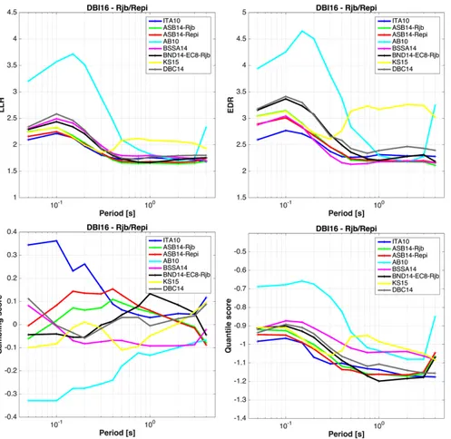
Concerning the first category, due to the basic role played by GMPEs in PSHA and to the huge number of prediction equations published in the last decade (see the list continuously updated by Douglas at http://www.gmpe.org.uk/), it was decided to focus on selecting and ranking the available models in a proper way rather than to develop new models. In addition to the MPS16 requirements listed above, the selection of suitable GMPEs was also performed according to the criteria of [31] and [32]. Two different strategies for ranking were followed. The first one estimates the performance of each GMPE against recorded strong-motion data available for Italy and Europe for several intensity measures (i.e., PGA, PGV and acceleration spectral ordinates in the range 0.05-4 seconds) using different scoring techniques, included the well-known method based on the log-likelihood value [33], the Euclidean Distance-Based Ranking (EDR) method [34] and two novel methods commonly used for evaluating general probabilistic forecasts, such as the pari-mutuel gambling score [35] and the scoring rule for quantiles [36]. The results of the ranking of models for active shallow crustal regions, and epicentral and Joyner-Boore distances metrics, are shown in Fig. 1.
Fig. 1 - Results of the ranking analysis using four methods: LLH (upper left), EDR (upper right), parimutuel gambling score (lower left) and quantile score (lower right). ITA10: [24]; ASB14: [37]; AB10: [40];
BSSA14: [41]; BND14: [38]; KS15: [42]; DBC14: [43].
The best performing models are the one specifically developed for Italy [24] or the most recent European GMPEs ([37], [38]). The second strategy for ranking is based on the comparison among several hazard estimates, produced varying the selected GMPE, and a set of strong-motion data recorded at Italian accelerometric stations where observations are available for at least 25 years. The comparison is performed through a likelihood value computed considering the number of stations where the estimated strong-motion parameter (i.e., PGA and several acceleration spectral ordinates) for a given probability level (or mean return period) is exceeded (for details about the methodology, see [39]).
About the second category, a new model for macroseismic intensity prediction, as a function of moment magnitude and epicentral distance, was developed and the IPE of [44] was updated using the most recent versions of the Italian earthquake catalogue CPTI15 (http://emidius.mi.ingv.it/CPTI15) and macroseismic database DBMI15 (http://emidius.mi.ingv.it/DBMI15) supplied by task 2. In addition, a set of probabilistic attenuation models as a function of epicentral intensity developed for whole Italy and volcanic area of Mount Etna [45] were implemented. Finally, the ranking of a set of selected IPEs for Italy was performed following the approach proposed by [46] using the DBMI15 macroseismic database as validation data set.
Based on ranking results, a score was assigned to each selected attenuation model to derive a preliminary weight in the ground-motion logic tree.
4.5. Task 5 – Computation and Rendering
To compute seismic hazard, we selected the code OpenQuake (www.openquake.org; [18]) because of several reasons, among which it is free; it is open source, so it is possible to verify the code. Moreover, OpenQuake is
developed by GEM (www.globalquakemodel.org) and it is possible to easily interact with the developer team for modification or integration to the code as well as to ask for developing dedicated functions; it is also possible to get quick assistance for problems concerning the elaboration or installation issues. Finally, the code is continuously updated and it is used by a wide community in several countries.
The final hazard data will be collected in a geographical database, according to the specification of DPC, to allow the direct use within the DPC systems. The database will be the reference container for all the uses of the model: webGis interfaces, file download, reports, etc. The selected database is PostgreSQL (http://www.postgresql.org) with PostGIS extensions (http://postgis.net): it is free and open source software widely used all over the world for a great number of different applications, that also require robustness and high performance, and it is one of the format accepted by DPC. The geographical data will be referenced using as reference system the geographical WGS84 (EPSG 4326).
Part of the effort will be to disseminate the resulting data in the form of graphs, tables, maps, through both paper and electronic means. These data do not require to be changed over the time after the publication, and the dissemination tools can take advantage from this feature. We had a previous experience in disseminating the data resulted from the previous national project, MPS04 [47], which turned out to be of great interest and successful: a webGIS application allowing to view hazard maps, hazard curves and uniform hazard spectra. At the time it was an innovative tool for this scientific sector, it still remains valid despite scarcely adoption in the world. Hazard data will be then disseminated developing an analogous web tool, with extended features, to allow the users to receive more information and additional formats.
Different ways of data rendering were considered, each one with distinctive features and needs, requiring specific solutions: interactive hazard maps with graphs (hazard curves, uniform hazard spectra, etc.) of single specific coordinates; search tools by meta data (i.e. the catalog); download of data files with the hazard values visualized on the maps, to allow the users to perform their own elaborations; static maps to be downloaded; generation of pdf reports of specific hazards and location.
Different aspects were taken in consideration while developing the system. The efficiency is a crucial aspect in the development of the webGIS application, as we already experienced hundreds of requests per minute during the earthquakes of Abruzzo in 2009 and Emilia in 2012. During such events the bandwidth is a typical limiting factor, therefore we preferred solutions requiring low amount of data transfer, i.e. using map images with limited geographical details rather than maps based on photo images, like those offered by Google Maps. We considered the possibility of directly handling the hardware infrastructure as a strategic solution, in order to be able to monitor the usage and to optimize the configuration and the application: this was opposed to using the “cloud”. We opted for an in-house server, by which it is possible to monitor the data access to the database and the system response, and possibly to scale-up the hardware. Another important aspect for an in-house solution with dedicated hardware is that upgrades of the O.S. and of the libraries can be turned down, and the application effectively frozen, avoiding the costs associated to the software upgrade and the associated application maintenance.
All the available information, organized in a web portal, will be provided with all the details required to public institutions for the publication (transparency) and to allow data re-use (open data). The complete documentation on the activity concerned with the realization of the MPS16 model will also be available.
4.6. Task 6 - Validation
In common practice, the reliability of a seismic hazard model is usually attributed on the consensus of the scientific community on the model's outcomes. A more objective approach is based on testing the seismic hazard model with the available data. Despite the obvious importance of this step to keep seismic hazard into a scientific domain, there is not yet a commonly accepted framework for testing seismic hazard models, and only a few approaches based on different assumptions have been proposed. The pervasive role of experts’ opinion, the heterogeneous probabilistic approaches to build the models, and the scarcity of independent data for evaluation make this issue extremely challenging, both from a theoretical and practical point of view.
Seismic hazard is essentially expressed in probabilistic terms. We defer to [48] and references therein for a detailed discussion on the most important theoretical issues associated with a proper and meaningful validation of seismic hazard models. Here we just mention that any meaningful validation of seismic hazard models has to be embedded into a suitable and consistent probabilistic framework. Here we adopt the framework proposed in [48], in which the probability represents the expected long-term frequency of a set of exchangeable events that, in turn, defines the so-called experimental concept of validation. The definition of the experimental concept becomes the cornerstone of any validation test and it provides a framework for a correct interpretation of the results.
As far as long-term seismic hazard models are concerned, seismologists cannot usually evaluate models using independent data as requested for pure scientific evaluation. Some efforts in this direction is ongoing, but with some severe limitations (e.g. [49]). Most of the times, as for MPS16, only past data, which have been used more or less directly for building the hazard model, can be used for testing. Hence, instead of using the term validation – that is the cornerstone of science – we prefer to use the less ambitious term “consistency” of the model's output with data, i.e., to check if – in a well-defined experimental concept – the model is able to describe satisfactorily the data that have been used to build the model. A good consistency of the model with past data does not guarantee the reliability of the model in anticipating ground shaking from future earthquakes; on the other hand, a failure of consistency testing would under-mine the credibility of the model to forecast future ground shaking. MPS16 model is composed of the convolution of two main components: the seismicity rate models and the GMPEs. The most important target of our analysis is testing the consistency of the whole MPS16 model. However, we also recognize the importance to evaluate the consistency of single components of the model, so we also test the consistency of the seismicity rate models and GMPEs (see subsection 4.4).
Besides estimating the consistency of the final MPS16 model, or some of its components such as the seismicity rate models, with past data, we also compared different models that form MPS16 to rank them ac-cording to their retrospective forecasting (hereafter pastcasting) performances; we name this procedure “scoring”. All hazard models (for instance, but not necessarily, the outcomes of a logic tree), and each single component will be also scored according to a few pre-selected specific metrics. The goal of scoring is to facilitate the merging of models in a final seismic hazard assessment.
Specifically, the testing of MPS16 was carried out in 4 different phases. In testing phase 1, we evaluated the consistency of the final MPS16 model using the past accelerometric data that are available in Italy. To this purpose we develop a new procedure to account properly the epistemic uncertainty. In testing phase 2, we test one of the outputs of MPS16, namely the seismic hazard model expressed in terms of macroseismic intensity. We compared the outcomes of the model with the intensity observations that occurred in the last centuries. In testing phase 3, we test for consistency each single seismicity rate model, comparing the rates with the seismicity that has been observed in the last centuries (taken from the CPTI15 catalog). In testing phase 4, we provide a quantitative scoring of each model based on the comparison of their past casting. This scoring could be useful to establish the weight of each model, but we underline that scoring a model is entirely based on data analysis, while establishing weights could require more subjective assessment, for instance, when the dataset used for scoring is not particularly large. The scoring is applied to the set of final hazard models as well as to single components such as the seismicity rate models and the GMPEs, using the databases described for the previous testing phases.
5. Conclusions
The national scientific community released a new seismic hazard model (MPS16) for Italy after a 2 years project that involved more than 150 researchers. The main aspect we took care is the agreement within a broad community for a transparent and reproducible procedure that explored the many epistemic uncertainties in the input definition. The final model is not yet completed at the moment of the submission of this paper, so it is not possible here to discuss its main features and results. We presented the roadmap delineated for realizing a huge number of activities during the project to obtain a model in line with the most advanced international standards in probabilistic seismic hazard assessment.
6. References
[1] Meletti C, Galadini F, Valensise G, Stucchi M, Basili R, Barba S, Vannucci G, Boschi E (2008): A seismic source model for the seismic hazard assessment of the Italian territory. Tectonophysics, 450 (1), 85-108. DOI:10.1016/j.tecto.2008.01.003.
[2] Meletti C, Rovida A, D’Amico V, Stucchi M (2014): Modelli di pericolosità sismica per l’area italiana: “MPS04-S1” e “SHARE”. Progettazione Sismica, 5 (1), 15-25. Doi: 10.7414/PS.5.1.15-25
[3] Slejko D, Peruzza L, Rebez A (1998): Seismic hazard maps of Italy. Annals of Geophysics, 41, 183-214.
[4] Cornell CA (1968): Engineering seismic risk analysis. Bulletin of the Seismological Society of America, 58, 1583-1606.
[5] Meletti C, Patacca E, Scandone P (2000): Construction of a seismotectonic model: the case of Italy. Pageoph, 157, 11-35.
[6] Camassi R, Stucchi M (1997): NT 4.1.1, un catalogo parametrico di terremoti di area italiana al di sopra della soglia di danno. Rapporto tecnico GNDT, Milano, 66 pp.. http://emidius.mi.ingv.it/NT/home.html.
[7] Albarello D, Bosi V, Bramerini F, Lucantoni A, Naso G, Peruzza L, Rebez A, Sabetta F, Slejko D (2000): Carte di pericolosità sismica del territorio nazionale. Quaderni di Geofisica, 12, Roma, 7 pp..
[8] MPS Working Group (2004): Redazione della mappa di pericolosità sismica prevista dall’Ordinanza PCM del 20 marzo 2003 n. 3274, All. 1. Rapporto conclusivo per il Dipartimento della Protezione Civile, aprile 2004, Istituto Nazionale di Geofisica e Vulcanologia (INGV), Milano-Roma, 163 pp., http://zonesismiche.mi.ingv.it/
[9] Stucchi M, Meletti C, Montaldo V, Crowley H, Calvi GM, Boschi E (2011): Seismic hazard assessment (2003-2009) for the Italian building code. Bulletin of the Seismological Society of America, 101, 1885-1911.
[10] NTC (Norme Tecniche per le Costruzioni) (2008): Norme Tecniche per le Costruzioni, Ministerial Decree 14/01/2008,
Official Gazette n. 29, 4 February 2008.
[11] Crowley H, Stucchi M, Meletti C, Calvi GM, Pacor F (2010): Revisiting Italian design code spectra following the L'Aquila earthquake, Progettazione Sismica 'Speciale Abruzzo' (special volume in English), 73-81.
[12] Meletti C, D’Amico V, Ameri G, Rovida A, Stucchi M (2012): Seismic hazard in the Po Plain and the 2012 Emilia earthquakes. Annals of Geophysics, 55 (4), 623-629. doi: 10.4401/ag-6158.
[13] Woessner J, Danciu L, Giardini D, Crowley H, Cotton F, Grünthal G, Valensise G, Arvidsson R, Basili R, Demircioglu MB, Hiemer S, Meletti C, Musson R, Rovida A, Sesetyan K, Stucchi M, the SHARE consortium (2015): The 2013 European seismic hazard model: key components and results. Bulletin of Earthquake Engineering, 13, 3553-3596.
[14] Visini F, Meletti C, D’Amico V, Rovida A, Stucchi M (2016): Comparing the European (SHARE) and the reference Italian seismic hazard models. EGU General Assembly 2016, Vienna, 18-22 April 2016.
[15] SSHAC (Senior Seismic Hazard Analysis Committee) (1997): Recommendations for probabilistic seismic haz-ard analysis: guidance on uncertainties and use of experts. Report NUREG-CR-6372, U.S. Nuclear Regulatory Commission, Washington D.C..
[16] Gardner JK, Knopoff L (1974): Is the sequence of earthquakes in southern California, with 836 aftershocks removed, Poissonian? Bulletin of the Seismological Society of America, 64, 1363–1367.
[17] Basili R, Valensise G, Vannoli P, et al. (2008): The Database of Individual Seismogenic Sources (DISS), version 3: Summarizing 20 years of research on Italy’s earthquake geology. Tectonophysics, 453, 20–43. doi: 10.1016/j.tecto.2007.04.014
[18] Pagani M, Monelli D, Weatherill G, Danciu L, Crowley H, Silva V, Henshaw P, Butler L, Nastasi M, Panzeri L, Simionato M, Vigano D (2014): OpenQuake Engine: an open hazard (and risk) software for the Global Earthquake Model. Seismological Research Letters, 85, 692-702.
[19] Frankel A (1995): Mapping Seismic Hazard in the Central and Eastern United States. Seismological Research Letters,
66 (4), 8-21.
[21] Kostrov VV (1974): Seismic moment and energy of earthquakes, and seismic flow of rock. Izv. Acad. Sci. USSR, Phys.
Solid Earth, Engl. Trans., 1, 23-44.
[22] Bird P, Liu Z (2007): Seismic hazard inferred from tectonics: California. Seismological Research Letters, 78 (1), 37– 48, doi:10.1785/gssrl.78.1.37.
[23] Woo G (1996): Kernel estimation methods for seismic hazard area source modelling. Bulletin of the Seismological
Society of America, 86, 353-362.
[24] Bindi D, Pacor F, Luzi L, Puglia R, Massa M, Ameri G, Paolucci R (2011): Ground motion prediction equations derived from the Italian strong motion database. Bulletin of Earthquake Engineering, 9 (6), 1899-1920, doi:10.1007/s10518-011-9313-z.
[25] Douglas J, Akkar S, Ameri G,Bard P-Y,Bindi D,Bommer JJ,Bora SS,Cotton F, DerrasB,Hermkes M,Kuehn NM,
Luzi L,Massa M, Pacor F,Riggelsen C,Sandıkkaya MA, Scherbaum F, Stafford PJ,Traversa P (2014): Comparisons
among the five ground-motion models developed using RESORCE for the prediction of response spectral accelerations due to earthquakes in Europe and the Middle East. Bulletin of Earthquake Engineering, 12 (1), 341-358, doi:10.1007/s10518-013-9522-8.
[26] Bozorgnia Y, Abrahamson NA, Al Atik L, Ancheta TD, Atkinson GM, Baker JW, Baltay A, Boore DM, Campbell KW, Chiou BS-J, Darragh R, Day S, Donahue J, Graves RW, Gregor N, Hanks T, Idriss IM, Kamai R, Kishida T, Kottke A, Mahin SA, Rezaeian S, Rowshandel B, Seyhan E, Shahi S, Shantz T, Silva W, Spudich P, Stewart JP, Watson-Lamprey J, Wooddell K, Youngs R (2014): NGA-West2 Research Project. Earthquake Spectra, 30 (3), 973-987, doi:10.1193/072113EQS209M.
[27] Petersen MD, Moschetti MP, Powers PM, Mueller CS, Haller KM, Frankel AD, Zeng Y, Rezaeian S, Harmsen SC, Boyd OS, Field N, Chen R, Rukstales KS, Luco N, Wheeler RL, Williams RA, Olsen AH (2014): Documentation for the 2014 update of the United States national seismic hazard maps. U.S. Geological Survey Open-File Report
2014-1091, 243 p., http://dx.doi.org/10.333/ofr20141091.
[28] Luzi L, Hailemikael S, Bindi D, Pacor F, Mele F, Sabetta F (2008): ITACA (ITalian ACcelerometric Archive): a web
portal for the dissemination of Italian strong-motion data. Seismological Research Letters, 79 (5), 716-722, doi:
10.1785/gssrl.79.5.716.
[29] Pacor F, Paolucci R, Luzi L, Sabetta F, Spinelli A, Gorini A, Nicoletti M, Marcucci S, Filippi L, Dolce M (2011):
Overview of the Italian strong motion database ITACA 1.0. Bulletin of Earthquake Engineering, 9 (6), 1723-1739, doi:
10.1007/s10518-011-9327-6.
[30] ESM working group (2015): Engineering strong-motion database, version 1.0, doi: 10.13127/ESM.
[31] Cotton F, Scherbaum F, Bommer JJ, Bungum H (2006): Criteria for selecting and adjusting ground-motion models for specific target regions: application to central Europe and rock sites. Journal of Seismology, 10 (2), 137-156, doi:10.1007/s10950-005-9006-7.
[32] Bommer JJ, Douglas J, Scherbaum F, Cotton F, Bungum H, Fah D (2010): On the selection of ground-motion prediction equations for seismic hazard analysis. Seismological Research Letters, 81 (5), 783-793, doi:10.1785/gssrl.81.5.783.
[33] Scherbaum F, Delavaud E, Riggelsen C (2009): Model selection in seismic hazard analysis: an information-theoretic perspective. Bulletin of the Seismological Society of America, 99 (6), 3234-3247.
[34] Kale O, Akkar S (2013): A new procedure for selecting and ranking ground-motion prediction equations (GMPEs): The Euclidean Distance-Based Ranking (EDR) Method. Bulletin of the Seismological Society of America, 103 (2A), 1069-1084, doi:10.1785/0120120134.
[35] Zechar JD, Zhuang J (2014): A parimutuel gambling perspective to compare probabilistic seismicity forecasts.
Geophysical Journal International, 199, 60-68. doi:10.1093/gji/ggu137.
[36] Gneiting T, Raftery AE (2007): Strictly proper scoring rules, prediction, and estimation. Journal of the American
Statistical Association, 102, 359-378.
[37] Akkar S, Sandikkaya MA, Bommer JJ (2014): Empirical ground-motion models for point- and extended-source crustal earthquake scenarios in Europe and the Middle East. Bulletin of Earthquake Engineering, 12 (1), 359-387, doi:10.1007/s10518-013-9461-4.
equations for the average horizontal component of PGA, PGV, and 5%-damped PSA at spectral periods up to 3.0 s using the RESORCE dataset. Bulletin of Earthquake Engineering, 12 (1), 391-430, doi:10.1007/s10518-013-9525-5. [39] Barani S, Albarello D, Spallarossa D, Massa M (2016): Empirical scoring of ground motion prediction equations for
probabilistic seismic hazard analysis in Italy including site effects. Bulletin of Earthquake Engineering (submitted). [40] Akkar S, Bommer JJ (2010): Empirical equations for the prediction of PGA, PGV and spectral accelerations in
Europe, the Mediterranean and the Middle East. Seismological Research Letters, 81, 195-206.
[41] Boore DM, Stewart JP, Seyhan E, Atkinson GM (2014): NGA-West2 equations for predicting PGA, PGV, and 5% damped PSA for shallow crustal earthquakes. Earthquake Spectra, 30 (3), 1057-1085, doi:10.1193/070113EQS184M. [42] Kuehn NM, Scherbaum F (2015): Ground-motion prediction model building: a multilevel approach. Bulletin of
Earthquake Engineering, 13 (9), 2481-2491, doi:10.1007/s10518-015-9732-3
[43] Derras B, Bard P-Y, Cotton F (2014): Towards fully data driven ground-motion prediction models for Europe. Bulletin
of Earthquake Engineering, 12 (1), 495-516, doi:10.1007/s10518-013-9481-0.
[44] Pasolini C, Albarello D, Gasperini P, D’Amico V, Lolli B (2008): The attenuation of seismic intensity in Italy part II: modeling and validation. Bulletin of the Seismological Society of America, 98, 692-708, doi: 10.1785/0120070021.
[45] Rotondi R, Varini E, Brambilla C (2015): Probabilistic modelling of macroseismic attenuation and forecast of damage scenarios. Bulletin of Earthquake Engineering (published online), doi: 10.1007/s10518-015-9781-7.
[46] Mak S, Clements RA, Schorlemmer D (2015): Validating intensity prediction equations for Italy by observations.
Bulletin of the Seismological Society of America, 105 (6), 2942-2954, doi: 10.1785/0120150070.
[47] Martinelli F, Meletti C (2008): A webgis application for rendering seismic hazard data in Italy. Seismological
Research Letters, 79 (1), 68-78. DOI: 10.1785/gssrl.79.1.68
[48] Marzocchi W, Jordan TH (2014): Testing for ontological errors in probabilistic forecasting models of natural systems.
Proceedings of the Natural Academy of Science, 111 (33), 11973-11978.
[49] Mak S, Clements RA, Schorlemmer D (2014): The Statistical Power of Testing Probabilistic Seismic-Hazard Assessments. Seismological Research Letters, 85, 781-783.