UNIVERSITÀ DEGLI STUDI DELLA TUSCIA DI VITERBO
DIPARTIMENTO DI SCIENZE DELL’AMBIENTE FORESTALE E DELLE SUE RISORSE
(Di.S.A.F.Ri)
CORSO DI DOTTORATO DI RICERCA
in ECOLOGIA FORESTALE - XVIII CICLO.
ANALYSIS OF THE CARBON CYCLE OF STEPPE AND OLD
FIELD ECOSYSTEMS OF CENTRAL ASIA
---
ANALISI DEL CICLO DEL CARBONIO DI STEPPE ED AREE
AGRICOLE ABBANDONATE DELL’ASIA CENTRALE
settore scientifico-disciplinare AGR05
Coordinatore: Prof. Paolo De Angelis
Tutor: Prof. Riccardo Valentini
, ,
r t
t t f
t
The scientist, by the very nature of his commitment creates more and more questions never fewer. Indeed the measure of our intellectual maturity, one philosopher suggests, is our capacity to feel less and less satisfied with our answers to better problems.
(G.W. Allport; Becoming)
Never fall in love with you hypo hesis.
(Peter Medawar)
Whenever I have found out that I have blundered, or that my work has been imperfect, and when I have been contemptuously criticized, and even when I have been overpraised, so tha I have felt mortified, i has been my greatest com ort to say hundreds of time to myself that "I have worked as hard and as well as I could, and no man can do more than this".
(Charles Darwin; Autobiography)
Some scien ists work so hard there is no time left for serious thinking.
Eurasian steppes cover a vast area of about 8·106 km2, of which a fraction between 60% and 70% was converted to agricultural use in the past, and have been poorly investigated in respect with the
exchanges of CO2 with the atmosphere while they could play a relevant role in the carbon uptake
located over the northern hemisphere lands at temperate latitudes. In particular, old agricultural fields abandoned after 1990 in former Soviet Union could contribute actively to the sequestration of atmospheric carbon, since after land use change they tend to restore the original stock of carbon of steppe ecosystems, that went partly lost with the agricultural use of the land. This study provides a quantitative characterization of the carbon pools, of the patterns of carbon allocation within the
ecosystems, of the CO2 exchanges between the biosphere and the atmosphere, as well as of the
response of CO2 fluxes to environmental drivers of true bunchgrass steppes and neighbouring old
agricultural fields hosting different temporal stages of recovering grassland located in the Republic of Hakasia and in the Republic of Tuva (Russian Federation).
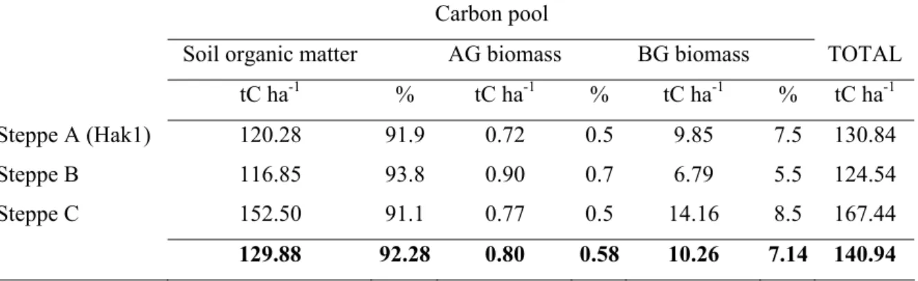
Within about 40 years, cultivations caused a loss of organic carbon not lower than 46%-52% in respect with the level of steppes (average carbon sotck: 140.9 tCha-1 in Hakasia and 45.5 tCha-1 in Tuva) and affected both the soil organic carbon pool, 80-92% of the lost carbon, and the belowground biomass pool for the remaining part.
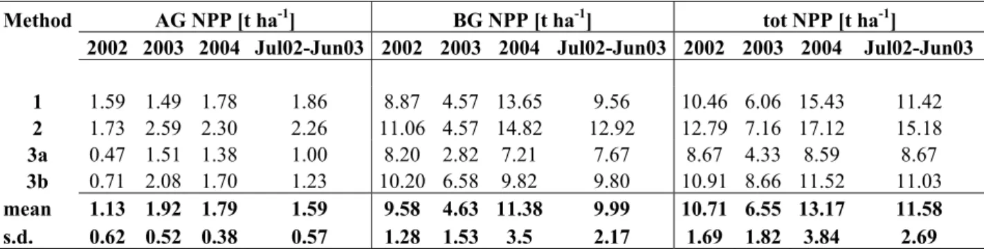
The biomass carbon stock of steppes of Hakasia and Tuva was found to be stored mainly in the belowground pool, with a proportion ranging 88-94%, due to the highly developed root system of perennial species. In old agricultural fields, belowground biomass was still predominant but the share of biomass found in the aboveground pool, from 12% to 42%, was larger than in steppes. The assessment of net primary productivity (NPP) at sites of Hakasia by different biometric methods ranged between 6.0 ad 13.1 t d.m. ha-1, and organicated carbon was allocated primarily to the root system, with a fraction varying between 70% and 90% for both steppe and old field ecosystems.
CO2 fluxes at ecosystem scale were monitored by eddy covariance technique over three stages of
an old field succession in Hakasia represented by an early stage (5 years since land use change), an intermediate stage (10 years) and a mature stage (steppe). Yearly CO2 exchange estimates disclosed all the sites to act as carbon sinks, with a strenght declining from the early stage (2.1 tC ha-1) to the
steppe ecosystem (1.1 tC ha-1). Also the amounts of carbon assimilated by photosynthesis (GPP)
and released to the atmosphere through ecosystem respiration (Reco) decreased over the stages of the succession, yielding the observed trend in the net ecosystem productivity (NEP).
The steppe ecosystem, even if characterized by lower carbon assimilation than old field ecosystems, displayed a less pronounced reduction of the photosynthetic process in response to extreme high air temperature and air dryness conditions, maintaining its efficiency in carbon uptake.
The steppe ecosystem was also found resilient to disturbances since after a fire burst before the onset of the growing season, it showed an enhanced carbon sequestration that could completely offset the amount of carbon lost from the burnt biomass.
The carbon budget of the true steppe, estimated additionally using the ecological inventory methodology based on the difference between net primary productivity and heterotrophic respiration (NEP=NPP-Rh), agreed with the result obtained with the micrometeorological technique.
The spatialization of the carbon balance observed at sites in the steppe region of the Republic of Hakasia, to assess the magnitude of the sink of steppes and old fields ecosystems in the Russian Federation, suggests a carbon sequestration of 0.17 PgC yr-1.
Le steppe eurasiatiche, che si estendono su di un’area di circa 8·106 km2 di cui tra il 60% e il 70% convertito in passato all’uso agricolo, sono state scarsamente oggetto di ricerche sugli scambi di CO2 con l’atmosfera, nonostante possano rivestire un ruolo rilevante nell’assorbimento di carbonio attualmente in atto da parte degli ambienti terrestri nelle zone temperate dell’emisfero boreale. In particolare i campi agricoli abbandonati a partire dal 1990 nell’ex-URSS possono contribuire attivamente al sequestro di carbonio dato che tendono a ripristinare lo stock originario di carbonio tipico delle steppe che si è parzialmente depauperato con l’uso agricolo del suolo.
Il presente studio ha come obiettivo la caratterizzazione quantitativa del ciclo del carbonio di steppe e campi agricoli abbandonati ospitanti diversi stadi temporali di una successione ecologica secondaria, di cui la vegetazione steppica rappresenta lo stadio finale, nella Repubblica dell’Hakasia e nella Repubblica di Tuva (Federazione Russa). Si analizzano gli stock di carbonio la loro distribuzione nei comparti (pools) degli ecosistemi, la produttività primaria netta e la sua
allocazione, gli scambi di CO2 tra ecosistema e atmosfera ed il controllo esercitato dai fattori
ambientali su flussi di carbonio.
In seguito a circa 40 anni di coltivazione, lo stock di carbonio negli agroecosistemi ha subito una diminuzione non inferiore al 46%-52% rispetto ai livelli degli ecosistemi di steppa (pari in media a 140.9 tCha-1 in Hakasia e a 45.5 tCha-1 a Tuva) a carico principalmente del carbonio organico del suolo (in ragione del 80%-92%) e della biomassa radicale per la restante parte.
Il carbonio nella biomassa delle steppe in Hakasia e a Tuva è risultato stoccato per l’88%-94% nella biomassa ipogea, costituita dall’apparato radicale particolarmente sviluppato delle specie perenni. Nei campi abbandonati, la biomassa ipogea rimane prevalente sebbene la biomassa epigea rappresenti una frazione, tra il 12% e il 42%, maggiore rispetto a quanto osservato per le steppe. La produttività primaria netta (NPP) stimata con diversi metodi biometrici per i siti dell’Hakasia è risultata compresa tra 6.0 e 13.1 t ha-1 di sostanza secca ed allocata prevalentemente nell’apparato radicale sia negli ecosistemi di steppa che negli ex-coltivi in proporzione variabile tra il 70% e il 90%.
La tecnica della correlazione turbolenta (eddy covariance) è stata impiegata in Hakasia per monitorare i flussi di CO2 a scala ecosistemica su tre stadi serali della successione innescata dalla ricolonizzazione dei campi agricoli da parte della vegetazione spontanea (pioniero-5 anni; intermedio-10 anni; finale-steppa). Il bilancio del carbonio su base annuale che ne è risultato ha evidenziato la capacità di sequestro del carbonio di tutti gli stadi analizzati che è massima nello stadio pioniero (2.1 tC ha-1) e decrescente nel tempo fino allo stadio di steppa (1.1 tC ha-1). Lo stesso andamento temporale caratterizza il carbonio assimilato per fotosintesi (GPP) e rilasciato in atmosfera per mezzo della respirazione ecosistemica (Reco), sebbene con tassi di variazione distinti che determinano le differenze osservate nella produzione netta ecosistemica (NEP).
L’ecosistema di steppa, nonostante sia caratterizzato da una minore capacità assimilativa rispetto agli stadi successionali precedenti, ha invece mostrato una maggiore capacità di mantenere l’efficienza nell’assorbimento netto di carbonio in condizioni ambientali di alta temperatura dell’aria e deficit di pressione di vapore. L’ecosistema di steppa è risultato anche dotato di buon livello di resilienza dato che ad un evento di incendio è seguita un’aumentata capacità assimilativa che nel corso di una singola stagione vegetativa ha portato a recuperare la quantità di carbonio perduto.
L’impiego di un approccio inventariale basato sulla differenza tra produzione primaria netta e respirazione eterotrofa (NEP=NPP-Rh) per la stima del bilancio del carbonio del sito di steppa è risultato convergente con quanto prodotto dal metodo dell’eddy covariance.
La spazializzazione delle stime di bilancio del carbonio ottenuto per i siti dell’Hakasia, finalizzata alla valutazione del potenziale del sequestro del carbonio atmosferico di steppe e campi agricoli abbandonati della Federazione Russa, indica un sink di 0.17 PgC yr-1.
INTRODUCTION... I BACKGROUND OF SCIENTIFIC RESEARCH ON THE CARBON CYCLE... I
CURRENT KNOWLEDGE, RELEVANCE AT GLOBAL SCALE, AND STEPS FORWARD IN THE
UNDERSTANDING OF THE CARBON CYCLE OF SIBERIA: THE TCOS-SIBERIA PROJECT.... III
FOCUS ON STEPPE ECOSYSTEMS: MOTIVATIONS AND OBJECTIVES OF THE STUDY... IV
1 STEPPES OF EURASIA
... 1
1.1 MAIN FEATURES OF VEGETATION AND CLASSIFICATION OF STEPPES... 1
1.1.1 Zonal types of steppes... 2
1.1.2 Distribution of vegetation according to edaphic characteristics ... 2
1.2 STRUCTURE AND ECOLOGICAL STRATEGIES OF STEPPE COMMUNITIES... 3
1.2.1 Community structure ... 3
1.2.2 Phenology... 4
1.2.3 Morphological adaptations ... 4
1.2.4 Functional adaptations... 5
1.2.5 Steppe ecosystems sustainability ... 6
1.3 LONGITUDINAL DIVISION OF EURASIAN STEPPES... 7
1.3.1 The Black Sea-Kazakhstan subregion ... 7
1.3.2 The Central Asian subregion... 8
1.4 STEPPES OF HAKASIA... 10
1.5 STEPPES OF TUVA... 12
1.5.1 Ulug-Khem basin... 12
1.5.2 Ubs-Nur basin ... 13
2 CARBON CYCLE AND CARBON SEQUESTRATION CAPACITY OF TEMPERATE GRASSLAND ECOSYSTEMS
... 15
2.1 CARBON CYCLE OF GRASSLAND ECOSYSTEMS WITH EMPHASIS ON THE ROLE OF SOIL... 15
2.1.1 The process of carbon sequestration in soils... 17
2.1.2 Turnover of SOM and capacity for long term carbon sequestration... 18
2.2 CARBON SEQUESTRASTION MAGNITUDE OF TEMPERATE GRASSLAND ECOSYSTEMS... 19
2.2.1 Climate-change effects on carbon sequestration of grasslands ... 21
2.2.2 Management effects on carbon sequestration ... 22
3 EFFECT OF LAND USE CHANGE ON CARBON STOCKS OF TEMPERATE GRASSLANDS AND LAND USE HISTORY OF EURASIAN STEPPES
... 25
3.1 CARBON DYNAMICS ASSOCIATED TO LAND USE CHANGE... 25
3.1.1 Conversion from pasture to crop... 26
3.1.2 Conversion from crop to pasture... 26
3.2 LAND USE CHANGE IN ARID AND SEMI ARID LANDS OF EAST AND CENTRAL ASIA... 28
3.3 LAND USE CHANGE IN STEPPE TERRITORY OF FORMER SOVIET UNION AND POTENTIAL OF CARBON ACCUMULATION... 31
4 RESEARCH SITES... 35
4.1 STUDY AREA IN THE REPUBLIC OF HAKASIA... 35
4.1.1 Research sites within the collective farm (sovkoz) of Solionoziornoe... 35
4.1.1.1 Land use... 35
4.1.2 Sites equipped with micrometeorological (eddy covariance) systems ... 40
4.2 STUDY AREA IN THE REPUBLIC OF TUVA... 42
4.2.1 The Ubs-Nur Hollow and the Ubsunurskaya Kotlvina Biosphere Reserve ... 42
5 CARBON STOCKS AND DISTRIBUTION INTO POOLS... 47
5.1 INTRODUCTION... 47
5.2 MATERIALS AND METHODS... 48
5.2.1 Definition of pools ... 48
5.2.2 Sampling design ... 48
5.2.3 Aboveground biomass ... 48
5.2.4 Belowground biomass ... 49
5.2.5 Soil organic matter ... 49
5.2.6 Statistical analysis ... 50
5.3 RESULTS... 50
5.3.1 Aboveground and belowground biomass ... 50
5.3.1.1 Hakasia ... 50
5.3.1.2 Tuva ... 52
5.3.2 Soil carbon and nitrogen stocks ... 53
5.3.2.1 Hakasia ... 53
5.3.2.2 Tuva ... 54
5.3.3 Total carbon stock and distribution into pools... 54
5.4 DISCUSSION... 55
5.5 CONCLUSIONS... 56
6 NET PRIMARY PRODUCTIVITY
... 61
6.1 INTRODUCTION... 61
6.2 MATERIALS AND METHODS... 63
6.2.1 Biometric measurements ... 63 6.2.2 NPP assessment... 63 6.2.3 Ingrowth cores... 65 6.3 RESULTS... 66 6.3.1 Biomass dynamics ... 66 6.3.2 NPP ... 70 6.4 DISCUSSION... 75 6.5 CONCLUSIONS... 76
7 CO2 FLUXES AT ECOSYSTEM SCALE BY EDDY COVARIANCE TECHNIQUE
77
7.1 USE OF THE EDDY COVARIANCE TECHNIQUE AS A TOOL TO CHARACTERIZE THE CARBON CYCLE... 777.2 MONITORING PERIODS AT THE SITES OF HAKASIA AND TUVA AND OBJECTIVES... 78
7.3 MATERIALS AND METHODS... 79
7.3.1 Theoretical background... 79
7.3.2 Implementation of eddy covariance flux measurements... 80
7.3.3 Data processing... 82
7.3.3.1 Computation of fluxes. ... 82
7.3.3.1.1 Sensible heat flux ... 82
7.3.3.1.2 Carbon dioxide and latent heat fluxes ... 83
7.3.3.2 Spectral corrections ... 84
7.3.3.3 Net Ecosystem Exchange... 86
7.3.3.4 Despiking... 86
7.3.3.5 The underestimation of night-time fluxes and the u* correction... 87
7.3.3.6 The u* threshold selection and uncertainty ... 88
7.3.3.7 Gapfilling... 88
7.3.3.7.1 Gapfilling of winter time NEE ... 89
7.3.4.2 Stationarity Test and Integral Turbulence Test... 91
7.3.4.3 Footprint analysis... 92
7.4 CARBON DIOXIDE FLUXES OVER A TRUE BUNCHGRASS STEPPE AND OLD FIELD ECOSYSTEMS OF HAKASIA... 97
7.4.1 Daily course of NEE... 97
7.4.2 Trend of daily integrated NEE ... 98
7.4.3 Partitioning into Reco and GPP... 100
7.4.4 Carbon balance ... 106
7.4.5 Response of ecosystem respiration to soil temperature and soil moisture... 110
7.4.6 Response of GPP to photosynthetically active radiation, air temperature and vapour pressure deficit. ... 119
7.4.7 Water Use Efficiency. ... 129
7.4.8 Discussion ... 131
7.4.9 Conclusions ... 133
7.5 CARBON DIOXIDE FLUXES OVER A DRY BUNCHGRASS STEPPE IN THE UBS-NUR HOLLOW (TUVA)... 134
7.5.1 Carbon dioxide flux measurements ... 134
7.5.2 Results and discussion... 135
7.5.3 Conclusions ... 141
8 CHAMBER BASED MEASUREMENTS OF CO2 EFFLUXES: PARTITIONING OF ROOT-DERIVED SOIL CO2 EFFLUXES AND CONTROL OF PHOTOSYNTHESIS OVER SOIL RESPIRATION
... 145
8.1 SOIL RESPIRATION: UNDERLYING PROCESSES... 145
8.2 FIELD EXPERIMENTS... 150
8.2.1 Applied methods for soil CO2 flux measurement partitioning... 151
8.2.1.1 Root exclusion ... 151
8.2.1.2 Shading and clipping. ... 152
8.3 CASE STUDY 1-PARTITIONING OF SOIL RESPIRATION OF HETEROTROPHIC AND AUTOTROPHIC ORIGIN IN A NATURAL STEPPE OF HAKASIA... 153
8.3.1 Soil CO2 fluxes: partitioning ... 153
8.3.2 Results and discussion... 153
8.4 CASE STUDY 2-PHOTOSYNTHESIS CONTROL ON SOIL RESPIRATION IN A NATURAL STEPPE OF HAKASIA... 156
8.4.1 Materials and methods ... 156
8.4.2 Results and discussion... 158
8.5 CONCLUSIONS... 161
9 MULTIPLE CONSTRAINED ESTIMATE OF NEP BY EDDY COVARIANCE AND ECOLOGICAL INVENTORY APPROACH... 163
9.1 MATERIALS AND METHODS... 164
9.1.1 Net primary productivity ... 164
9.1.2 Eddy covariance measurements ... 165
9.1.2.1 Gapfilling... 166
9.1.2.1.1 Non linear regressions. ... 166
9.1.2.1.2 Marginal Distribution Sampling... 167
9.1.2.1.3 Artificial Neural Networks ... 167
9.1.2.2 Flux partitioning ... 167
9.1.3 Soil CO2 fluxes... 168
9.1.4 Uncertainty analysis in inventory and eddy covariance based estimates of NEP.... 168
9.2.3 Comparison between eddy covariance system and chamber based measurements of
total ecosystem respiration... 175
9.2.4 Eddy covariance measurements ... 175
9.2.5 Comparison of carbon budget by ecological inventory and eddy covariance. ... 179
9.3 DISCUSSION... 179
9.4 CONCLUSIONS... 181
10 SYNTHESIS OF THE MAIN FINDINGS AND OUTLOOK ON THE ROLE OF STEPPE ZONE OF RUSSIAN FEDERATION IN THE GLOBAL CARBON CYCLE.
... 183
10.1 ROLE OF STEPPE ZONE OF THE RUSSIAN FEDERATION IN THE GLOBAL CARBON CYCLE185 10.2 CONCLUSIVE REMARKS... 187
Introduction
Background of scientific research on the carbon cycle
The atmosphere in the last century has experienced rapid changes in its chemistry due to human activities, at unprecedented rates at least during the last 20000 years: global atmospheric
concentrations of carbon dioxide (CO2), methane (CH4) and nitrous oxide (N2O), the main
greenhouse gases (GHGs), have indeed increased remarkably, starting already since 1750, and presently far exceed pre-industrial values.
This increase of carbon dioxide was determined in the first place by the burning of fossil fuels and, with a smaller but significant contribution, by the deterioration of the original carbon stocks of terrestrial ecosystems induced by deforestation, agricultural practices and generally associated with land use changes. Emissions of methane and nitrous oxide are primarily due to agricultural activities and are proportional to the intensity of the agricultural management.
Although the tendency of the scientific research at present is to investigate on all the GHGs, tracking the exchanges of these gases between the biosphere and the atmosphere, in the last decade the largest part of the efforts was focused on the quantitative study of the carbon cycle, the
ensemble of the exchanges of carbon, in the form of CO2, among the atmosphere, the terrestrial
ecosystems and the oceans by means of the processes of photosynthesis, respiration and dissolution.
Carbon dioxide is the most important greenhouse gas, and its global atmospheric concentration has increased from a pre-industrial value of about 280 ppm to 379 ppm in 2005. The analysis of the this trend reveals that, despite of the year to year variability in the growth rates, the annual carbon dioxide concentration growth-rate was larger during the last 10 years (1995 – 2005 average: 1.9 ppm per year), than it has been since the beginning of continuous direct atmospheric measurements (1960–2005 average: 1.4 ppm per year). The picture becomes concerning when we consider that the atmospheric concentration of carbon dioxide in 2005 exceeds by far the natural range over the last 650000 years (180 to 300 ppm) as determined from ice cores, and that at the same time annual anthropogenic carbon dioxide emissions are increasing worldwide. Fossil carbon dioxide emissions passed from an average of 6.4 [6.0 to 6.8] GtC per year in the 1990s, to 7.2 [6.9 to 7.5] GtC per year in 2000–2005, while carbon dioxide emissions associated with land-use change are estimated to be 1.6 [0.5 to 2.7] GtC per year over the 1990s, although these estimates have a large uncertainty.
The influence of anthropogenic GHG emissions on the global climate has been an extremely vivid matter of debate among the scientific community, interesting also the public opinion in recent years as long as the awareness of the drastic impacts of climate warming over human life spread wider.
The climatic records show that eleven of the last twelve years (1995 -2006) rank among the 12 warmest years in the instrumental record of global surface temperature (since 1850) and that the linear warming trend over the last 50 years (0.13 [0.10 to 0.16]°C per decade) is nearly twice that for the last 100 years. The global atmospheric temperature increase from 1850 – 1899 to 2001 – 2005 is 0.76 [0.57 to 0.95]°C.
If on the one hand the warming of the climate system is considered unequivocal, as it is more and more evident from observations of increases in global average air and ocean temperatures, widespread melting of snow and ice, and rising global mean sea level, on the other hand the effect of anthropogenic GHG emissions over climate has been at first only cautiously related to the climate warming as a hypothesis to explain global warming. That hypothesis started to be corroborated by an increasing bulk of experimental data, as long as new research projects were launched to address the new challenging issue.
In 2001, the Intergovernmental Panel on Climate Change (IPCC) concluded in the Third Assessment Report that “most of the observed warming over the last 50 years was likely to have been due to the increase in greenhouse gas concentrations”. Since then a considerable breakthrough in the understanding of anthropogenic warming influence was achieved: in the latest Fourth Assessment Report of the IPCC, partly released in February 2007, the human activities since 1750 are claimed to be have been responsible, at a high level of confidence, for the climate warming with a radiative forcing of +1.6 [+0.6 to +2.4] Wm-2 and discernible human influences are extended to other aspects of climate, including ocean warming, continental-average temperatures, temperature extremes and wind patterns.
The future scenarios projected by IPCC for the next two decades imply a warming of about 0.2°C per decade and even if the concentrations of all greenhouse gases and aerosols had been kept constant at year 2000 levels, a further warming of about 0.1°C per decade would be expected. Nevertheless the rate of emission of CO2 due to human activities exceeds the actual rate of increase
of CO2 concentration measured in the atmosphere. This imbalance was noted in the early 1990’s
and could not be explained only by the amount of CO2 dissolving in the oceans, leading to
postulate the existence of a net uptake of atmospheric CO2 by terrestrial ecosystems. The amount of this term of the global carbon cycle, generally indicated as “missing sink”, is estimated to be about 2.9±1.1 GtG (Houghton, 2003).
Therefore, since the 1990’s there was a major research effort to resolve uncertainties in the location and magnitude of sinks. The issue was tackled either by the establishment of global networks of research sites worldwide for surface flux measurements such as in the Euroflux, Ameriflux and LBA projects, and by intensifying the monitoring of CO2 and other carbon cycle relevant tracers in the lower troposphere.
Current knowledge, relevance at global scale, and steps forward in the
understanding of the carbon cycle of Siberia: the TCOS-Siberia project
The research activities upon which the present doctoral thesis is based, were carried out in the framework of a EU project, the Terrestrial Carbon Observing System–Siberia (TCOS-Siberia, EVK2-CT 2001-00131), aimed at enhancing the understanding the carbon cycle of this particular region of the Northern Hemisphere.The selection of Siberia as a target for investigation relies behind the fact that from atmospheric
measurements of the CO2 concentration it has been inferred that a substantial net carbon uptake
takes place in temperate latitudes of the northern hemisphere (Keeling et al., 1989, Tans et al. 1990), with a significant fraction over the continents.
It is reasonable to state that Siberia contributes in an important way to the northern hemisphere sink as it constitutes one of the most important terrestrial components of the global carbon cycle with an area of 13·106 km2, an amount of 74 PgC stocked in vegetation and 249 PgC in soils (Dixon et al., 1994), and an estimated Net Primary Productivity of 1-3 PgC yr-1 (Schulze et al., 1999).
At present there is still a modest understanding of the role of this region in the global carbon cycle, due to the scatter in the results produced by the few researches on the topic, although substantially they confirmed the hypothesis of Siberia being a hotspot in the global biogeochemical cycles. From the side of a top-down approach, based on inversion models, Bousquet et al. (1999) located the area with the largest sink in the North Asian continent, with a strength of the Asian boreal area of 1.5±0.7 Pg C yr-1, whereas they found a source in the global arctic area, North of 65 °N, of 0.2 ± 0.3 Pg C yr-1. Gurney et al. (2002) found a sink of 0.5 Pg C yr-1 in Boreal Asia and Rödenbeck et al. (2003) found a sink of 0.4 Pg C yr-1 in the Northern Hemisphere lands, largely located in North America, but a roughly balanced budget for Eurasia.
The TCOS-Siberia project implemented a continental scale observing system for an evaluation of the net Siberian carbon balance and its inter-annual variability. This objective was pursued by an integration of a “top-down” and “bottom-up” approaches where the first implies that atmospheric measurements of the concentration of the greenhouse gases are assimilated in inversion models to estimate magnitude and uncertainty of surface sources and sinks that are consistent with the observations, while the latter is based “bottom-up” point-wise flux measurements for various ecosystems, which are then aggregated to the regional scale.
Under the TCOS-Siberia project a network of long-term surface CO2 flux-measuring stations was
developed. These were located in a west-east transect (Bialystok, Fedorovskoje, Zotino, Yakutsk) cutting the boreal forest (taiga) of Russian Federation along 60°N , and were complemented by stations in the steppes of Hakasia in the south (54°N) and in tundra ecosystems (Cherskii, Chokurdakh) in the north (70°N).
The creation of such a network comprising the major ecosystem types (taiga, tundra, steppe) has a fundamental importance because the contribution of the different biomes to the aggregated continental flux is still a largely open question.
In particular, the role of forest biome has been approached by several studies based on biomass inventory that converged in reckoning the Russian taiga as a sink of atmospheric carbon:
Kolchugina and Vinson (1993) suggested a sink of 0.485 Pg C yr-1; Nilsson et al. (2000) and
Shvidenko & Nilsson (2003) found sinks of 0.42±0.07 Pg C yr-1 between 1961–1998 including
land-use change and peat-land dynamics, while Liski et al. (2003) suggest a sink of 0.43 Pg C yr-1. On the contrary there is a poor knowledge of the steppe biome in respect with its role as a carbon source/sink, since former studies focused mainly on the assessment of net primary productivity of these ecosystems (IGBP Programme) and its relation to the degree of grazing pressure. In the
global distribution of the monitoring stations of CO2 fluxes, gathered in the FLUXNET network,
Eurasian steppes are very weakly represented, and apart from the stations established during the TCOS-Siberia activities, in the knowledge of the writer there exists only one long term site, located in Mongolia, that produced published results on the net ecosystem exchange of a steppe ecosystem (Li et al., 2005).
Focus on steppe ecosystems: motivations and objectives of the study
Eurasian steppes cover an extremely vast area of about 8·106 km2, and are a relevant tile in the reconstruction of the continental carbon cycle of Siberia. Yet an analysis of the ecology of the steppes in respect with the carbon balance cannot avoid to take into consideration their land use history and actual management. A fraction between 65-70% of the steppes area was converted to agricultural use in the past, particularly during Soviet times, in order to create the so called “wheat field of Russia”. Since the breakdown of the USSR, a noticeable fraction of agricultural land
(lowest estimate: 22·106 ha between 1992-2003) was abandoned and is currently in the stage of
recovering steppe. The recover of the natural communities typical of steppe, after a disturbance that is widely associated to an impoverishment of the carbon stock, may represent a pre-eminent factor leading to carbon sequestration since these ecosystems tend to restore their carbon stocks to the original levels.
The aim of this study was to characterize the carbon cycle of natural and recovering steppe ecosystems of Central Asia. The location selected for the study were the steppes of the Shira region, in the Republic of Hakasia (Russian Federation), where the largest part of research efforts were concentrated, and the steppes of Ubs-Nur Hollow Reserve, in the Republic of Tuva (Russian Federation), differing in a higher climatic continentality and lower productivity.
In the Shira region, activities were carried out over a natural bunchgrass steppe and two successional stages of recovering steppe (old fields) aged 5 and 10 years since abandonment of agriculture were monitored during a 3 year campaign (2002-2004).
The overarching aim was approached by the use of different methods pursuant to the following specific objectives of the research:
1. Quantification of the carbon stock and analysis of pattern of distribution of carbon within aboveground biomass, belowground biomass and soil organic matter over the old field ecological succession. (Chapter 5)
2. Assessment of Net Primary Productivity, comparing different computational methods and field techniques for the assessment of aboveground and belowground NPP. (Chapter 6) 3. Assessment of the Net Ecosystem Productivity, by micrometeorological (eddy covariance)
technique; partitioning of fluxes into Gross Primary Productivity and Total Ecosystem
Respiration; analysis of the response of CO2 fluxes to the main environmental forcings.
(Chapter 7)
4. Chamber based measurements of soil CO2 effluxes in the context of experiments aimed at:
(i) partitioning soil respiration into autotrophic and heterotrophic component by root
exclusion technique; (ii) testing the control of photosynthesis over soil CO2 effluxes.
(Chapter 8)
5. Constraint of Net Ecosystem Productivity by multiple methodological approaches: eddy covariance versus ecological inventory. (Chapter 9)
In the case of the steppes of Tuva, the investigated sites included a natural dry bunchgrass steppe and an abandoned agricultural field since 12 years. Results are limited to objective 1, for both sites, and objective 3, for the natural dry steppe only, of which results from a short-term record of CO2 fluxes measured by eddy covariance technique are presented.
1 Steppes of Eurasia
The steppes of Eurasian continent form a well defined region occupying a vast area between 48 °N and 57 °N latitude and 27 °E to 128 °E longitude. Given the great expanse of steppe region, stretching for 800-1000 km from north to south and about 8000 km from west to east, a remarkable diversity of steppe communities is found.
1.1 Main features of vegetation and classification of steppes
Perennial microtherm xerophilous, and often sclerophyllous, bunch grasses predominate in steppe communities. These grasses are usually species of the genera Agropyron sp., Cleistogenes sp.,
Festuca sp., Helictotrichon sp., Koeleria sp. and Stipa sp.. Dominants also include bunch species of
sedges (Carex sp.), and, in central Asia, of species of bunch forbs (Allium sp. and Filifolium sp.). Dominant bunch grasses form the basis of plant community and provide most of the phytomass: these are usually composed of a combination of relatively tall bunch grasses, mostly species of
Stipa, of shorter bunch grasses of the genera Cleistogenes sp. and Festuca sp., and sometimes of
dwarf bunch species of Carex spp.or dwarf species of Stipa spp..
Forbs (herbaceous dycotiledons and non gramineous monocotyledons, usually of the families
Iridaceae and Liliaceae ) are often associated to bunch grasses. The number of species of forbs and
their proportional contribution to biomass decreases from north to south within the steppe region, because of increased aridity of climate. In the most arid semi-desert and desert steppes communities of dwarf half shrubs also occur, consisting mostly of species of the genus Artemisia
sp..
The rhizomatous grasses and sedges do not form a clearly defined structural group in zonal steppe communities, but they are abundant in more northerly grasslands. The relative vigour of the various species and of the one structural group compared to another, change with fluctuation in precipitation, therefore the vegetative cover exhibits considerable inter-annual variation.
Plants in the dominating structural part of the plant community grow during the whole vegetative period , but during droughty months in summer (July and early August) their rate of development is retarded overmuch of the steppe region. This period of semi-dormancy occurs throughout the steppes of the European part of the former Soviet Union, as well as in the northern part of Kazakhstan and south western Siberia. In these regions growth is most rapid during June, the month of greatest precipitation. To the east, in the Daurian steppes, maximum precipitation occurs in July and August and the maximum development of vegetation takes place later than in western regions.
1.1.1 Zonal types of steppes
In the steppe region different zonal types of steppe which successively replace one another from north to south are met, following conditions of decreasing precipitation, increasing aridity and temperature summations and lengthening of growing season.
The classification of steppe according to Lavrenko (1970) distinguishes four types of steppe: 1. meadow steppe (forest steppe), in semi humid climate.
2. true or typical steppe divided into: (a) bunch-grass steppes with many forbs in semi-arid climate; (b) bunch-grass steppes with few forbs, in arid climate.
3. desertified bunch grass and dwarf half shrub-bunch grass (semi-desert steppe), in very arid climate.
4. desert dwarf half shrub bunch grass steppe in hyperarid climate.
The northern meadow steppes are characterized by the dominance of mesoxerophilous bunch grasses and sedges and by the abundance of xeromesophilous.
The typical or true steppes are distinguished by greater aridity of habitat, domination of xerophilous species of bunch grasses, and by a lower abundance of forbs (which are of a more xerophilous character than those in the meadow steppe).
The southern semi-desert and desert steppes are more arid than the preceding types, the most xerophilous bunch grasses and dwarf half shrubs being dominant.
Many other structural features change with increasing aridity. Species diversity is reduced from 40-50 species per square meter in meadow steppe to 12-15 species in semi desert and desert steppes. The height of the grass canopy decreases from 80-100 cm in the north to 15-20 cm in the south and foliage cover decreases from 70-90% to 10-20% and even less.
The vegetative cover of the forest steppe zone was, in the past, a mosaic of meadow, grassland and forest. In the European part of the former Soviet Union the principal tree was Quercus robur L:. These forest stands occurred on well drained catchments along the slopes of rather large rivers. At present they have been preserved only as small tracts. In the zone of true steppes, patches of trees grow only along the slopes of ravines. In the western Siberian forest steppe, as well as in the low mountain ranges of Central Kazakhstan, small tract of Betula pendula Roth., B.pubescens and
Populus tremula L. are typical around shallow depressions. More or less steppified forests of Pinus sylvestris L. also grow along the flood plains and terraces of rivers throughout the Eurasian forest
steppe and in low mountain ranges in Central and Northern Kazakhstan. Larix gmelinii Rupr. and
L.sibirica Ledeb. occur in the mountainous forest steppe of Transbaikal and Mongolia.
1.1.2 Distribution of vegetation according to edaphic characteristics
Most types of steppes typically grow on Chernozem and chestnut (Kastanozem) soils (FAO soil classification). However, much of the variation in vegetation within each of the zonal types of
steppe is related to edaphic characteristics. The vegetation growing over flat, well drained plains with loamy soils, defined as plakor, most fully reflects zonal climate. Variations from this which affect the nature of vegetation are found in sands and loamy sands (psammophytic and hemi-psammophytic conditions), in stony and gravely soils (petrophytic conditions) and in soils with high salt content (halophytic conditions).
In hemi-psammophytic and psammophytic subtypes of steppes, the principal dominants are specific groupings of bunch grass species of Agropyron spp., Festuca spp., Koeleria spp. and Stipa spp.. Areas of gravely soils, in low hills and intermountain plains, are characterized by communities of dwarf half-shrubs of several families, especially Asteraceae, Cariophyllaceae, Lamiaceae and
Scrophulariaceae. Communities of dwarf half-shrubs with or without scattering of bunch grasses
and sedges are often formed on rock outcrops almost devoid of soil. In some places within the steppe zone, shrubs are dominant in diluvial loamy, sandy and gravely deposits.
These shrub steppes are widely distributed over the steppe region of Eurasia, especially in Eastern Kazahstan and in Mongolia. And are characterized by abundance of the species Caragana and
Spirea spp..
Thickets of steppe shrubs occur on the slopes of ravines, in gullies formed by water erosion and in the margins of forest steppes. These are composed by the representatives of many genera, including
Amygdalus sp., Calophaca sp., Caragana sp., Cerasus sp. and Cotoneaster sp..
1.2 Structure and ecological strategies of steppe communities
1.2.1 Community structure
Considerable variability exists in the structure of the above-ground and below-ground parts of communities in different subzones of the steppe, driven by differences in aridity. The proportion of soil covered by the vegetative canopy decreases from approximately 90% in the meadow steppe of the Black Sea region to about 10% in the desert steppe of Mongolia. Species diversity decreases along this same gradient from 22-36 species per square meter to only 7-10 species. Similarly also the height of grasses decreases from 80 cm or more in meadow steppes to only 5-8 cm (10 cm in moist years) in desert steppes.
Although the layer of grasses and dwarf-half shrubs constitutes the basic canopy of steppe vegetation, other strata are usually present. In meadow steppes a layer of mosses is often present (most commonly of Thiudium abietinum). In dry and semi-desert steppes of Kazakhstan, especially on sandy and stony soils, lichens (mainly Parmelia vagans Nyl..) form a rather thick cover on the soil surface.
The whole Eurasian steppe region is characterized by a well formed, but rarefied shrub layer (particularly of species of Caragana and Spirea) which is usually taller than grasses, reaching a height of 30 to 100 cm.
In the grass canopy of the forb-bunch-grass steppes, three sublayers are clearly distinguished: one of tall grasses (species Helictotrichon and Stipa ) and of dicotyledonous forbs; a second of low bunch grasses and dicotyledonous forbs; and a third stratum of ephermerals, often reaching several centimetres in height. Similar sublayering occurs in semi-desert and desert steppes.
1.2.2 Phenology
Phenological development of steppe species is highly diverse, both in the duration of the vegetative period and in the timing of the phenological phases (aspects), their number and their prominence, in response to variations in temperature and moisture supply.
In the steppified meadows of the central chernozem region (forest steppe) of the European part of former Soviet Union, where the vegetative period is from April to September, some species are flowering at all times and as many as eleven flowering phases can be identified.
In more xerophitic steppes of the same region, where growth begins in the second half of April and continues until early October, no pronounced period of semi-dormancy occurs, as in southern steppe.
In the bunch grass dry steppe of the Black Sea region and Kazakhstan where the vegetative period is still longer (from March to early November), a well pronounced period of semi-dormancy occurs during summer (late June and early July).
In the semi-desert steppe of Kazakhstan, where the vegetative period is from 7 to 8 months long, as well as in the dry steppe, the period of semi-dormancy lasts for one to one and a half months. In the extremely adverse environment in the desert steppe of Mongolia, growth begins between early April and early June depending on the occurrence of rainfall; nevertheless there is a general tendency towards an increasing number of species growing from spring to summer, the time of maximum precipitation.
1.2.3 Morphological adaptations
The dominating species in steppe communities are bunch grasses with pronounced xeromorphy of aboveground organs. The main feature of their xeromorphism is the presence of narrow, almost threadlike, more or less folded leaves. The stomata are located on the inner surface of the folded leaves, where they are protected during dry and hot weather. They are able to open at the moment of unfolding of the leaf during moist periods. These characteristics of leaves are very important adaptive features of steppe grasses.
The bunch life-form which predominates among species of the steppe, evidently has an advantage over the other life forms in adjusting to a tenuous supply of moisture. This is achieved by burial of vegetative buds, so that the basis of the tillers are positioned deeper in the soil. This protects them better than species of other life forms from grazing and trampling by wild and domesticated
ungulates. The bunches assist in the accumulation of snow and dust, which add to the supply of moisture and nutrients.
The underground parts of steppe plants also have characteristics that facilitate survival under adverse conditions such as a fibrous root system, typical of most plants of the steppe, providing a great number of small roots and root hairs which penetrate densely throughout the soil. The surface area of the root system is very great in relation to mass, a characteristic that is very important under conditions of low soil moisture.
The major amount of under-ground biomass was found to be in uppermost 50 cm, in the humus layer of the soil, whereas in the shallower soil of the southern steppes (Black sea steppes) the roots are concentrated in the uppermost 30 cm (Shalyt, 1950, 1952). In semi-desert steppes, the major portion of the root biomass is located in the top 20 cm of soil. In meadows the root system is also concentrated in the upper 50 cm, but the roots do not penetratre as deeply as in the steppe, where the moisture supply is more limited (Lavrenko, 1941).
1.2.4 Functional adaptations
An adaptive feature to survive in environments with low temperatures throughout the vegetative period, as in southern Mongolia, is the plasticity in respect with photosynthesis. For example, Stipa
gobica Roschev. has a rather high photosynthetic performance at temperatures much lower than its
optimal for this activity. At 0° and 10°C it is able to absorb, respectively, 22% and 56% of the amount of carbon dioxide which it fixes at optimum temperature (which varies from 20° to 25°C). This plasticity is a feature of the adaptation of many species to survive in southern Mongolia, where low temperatures are throughout the vegetative period. Such plasticity is not inherent in desert species.
Other adaptive features operate at the population level. For example, the steppe community is able to compensate for an adverse environment by rare and irregular peaks in rates of germination of seeds and survival of seedlings. This is especially important in the dry conditions of dry steppes. Even in the meadow of the Black Sea region indeed, where the annual precipitation reaches 600 mm, great fluctuations are observed in the time of appearance and abundance of seedlings as well as the numbers of juvenile individuals (Kamenetskaya, 1949).
Most steppe species are both anemphilous and anemochoric. The regimes of flower opening and pollination are generally controlled by humidity of the air and the wind, which is almost constant over steppes, is the controlling factor of distribution of fruits and seeds.
1.2.5 Steppe ecosystems sustainability
Steppe ecosystem sustainability is defined as capability of a steppe vegetation community to maintain its structure and functions for an infinite period of time under moderate grazing activity and recover back to the initial state once a moderate or a high grazing stress is removed.
The main steppe sustainability contributors are rapidly changing species composition, the effective use of various plant survival strategies, high dominant species productivity, accumulation of live plant parts mostly below ground, as well as spatial and temporal variability of soil nutrient availability.
Like other grass ecosystems, steppes are permanently under succession, as their biota species composition depends on management regime and particularly on grazing activity whose level varies place to place.
Dominant plant species structure is known to change drastically during post-grazing steppe recovery and during steppe degradation due to heavy grazing. In central Asian steppes it was found that the greater the grazing stress the bigger the proportions of Artemisia frigida (Willd.) and
Potentilla acaulis L. and the less the stress, the greater the graminoids proportion in green biomass.
In degrading dry Tuva steppes, for example, the graminoids proportion in aboveground biomass decreases compared to stable steppes and increases in recovering steppes of the same type.
It is rapid replacement (succession) of pre-disturbance species by others, which are more adapted to a given grazing level, that provides green biomass load recovery and makes a certain vegetation structure sustainable and maintains also the productivity potential of steppe ecosystems.
Grazing has been a direct influence historically inherent in steppe ecosystem evolution. As a result, steppe plants developed certain strategies of adaptation to grazing. One of them is redistribution of assimilates between green and below-ground plant parts when a stress gets severer.
Studies on steppes of Tuva (Tilianova, 1999) evidenced how species appeared to transport more than 70% of dry matter to their below-ground parts. The plants were found to have different strategies of carbon allocation between their above- and below-ground parts in response to increasing grazing stress. Sedges and Stipa krylovii Roschev. showed a sudden increase in the rate of transporting organic substances to roots with severe grazing. Helictotrichon desertorum Less. seemed incapable of redistributing organic substances rapidly among its parts to result in decreasing the species abundance under moderate grazing and almost complete elimination of the
species from the grass cover under overgrazing. Festuca valesiaca (Schleicher ex Gaud.) and
Cleistogenes squarrosa (Trin.) Keng are known to be very resistant to biting tops off and
trampling, although the rate of organic substance transport to the roots decreases for these species under heavy grazing. Their capability to recover, once their green biomass is consumed, is due to shooting from auxiliary buds and the ability of their terminal buds to produce two leaf generations. Such strategies can promote species survival and growth under increasing aridity and grazing. Coexistence of species having different stress adaptation strategies maintains biodiversity and functional heterogenity of a steppe ecosystem and, hence, its sustainability.
Below-ground accumulation of the plant parts playing the key role in regeneration reflects the steppe strategy developed in the course of evolution as a survival tool for vegetation suffering from long, cold and often dry winters and periodical severe summer droughts. In early spring and following drought spells, below-ground plant parts may support the development of above ground organs and the viability of photosynthetic tissues.
The below-ground layer can be defined as the steppe biodiversity storehouse. There seeds, the genetic fund of a community, are stored. This is where species manage to survive not only short-term frost or droughts, but also long-short-term (tens and hundreds of years) grazing influence. Moreover, rapid replacement of the dominant species above ground would be impossible if their rhizomes and regeneration nodes could not survive in the soil.
1.3 Longitudinal division of Eurasian steppes
The structure and floristic composition of vegetation of Eurasian steppes change from west to east accordingly to the degree of continentality of the climate which is expressed particularly in sharp fluctuations in the amount of precipitation and heat in different seasons of the year, as well as between years. The following sections can be recognized:
1. the temperate continental southern European part of the former Soviet Union and Romania 2. the continental southern part of Western Siberia and Northern Kazakhstan
3. the hyper-continental southern part of Eastern Siberia and Central Asia (including steppes of Trans-Baikal and Mongolia)
4. the temperate continental plains of north eastern China and adjacent meadow steppe. The boundary layer between the continental and hyper continental zones is used as a basis for dividing the Eurasian steppe into two sub regions: Black Sea-Kazakhstan and Central Asian (Dauro-Mongolian).
1.3.1 The Black Sea-Kazakhstan subregion
This includes the extensive plains of eastern Europe, the plain in the southern part of the Western Siberian lowland, the plain of western Kazakhstan to the east and south of the Ural mountains, the low hills and low mountains of central and eastern Kazakhstan respectively. Mountains are situated only in the extreme south–east , including the southern Altai, the Kalbinsk mountain ridge and the Targabatai and Saur ridges, which all exhibit a well pronounced altitudinal zonality of vegetation. The Ural mountains and the Ural river constitute an inner boundary that separates the western part of the subregion, where climate is temperate continental, from the continental block of zones on the east.
In this subregion spring (April-May) is relatively warm, with considerable precipitation and June is the month of highest precipitation. The soils over the most of this subregion are typical deep
southern chernozems, while chestnut soils occur only in the south. Salinized, solonetz and solonchak soils are common in the chestnut soil area and also in the chernozem soils of south-western Siberia.
The dominants include the following species of Stipa: S.dasyphylla Lindem., S.pennata L.,
S.pulcherrima Koch, S.tirsa Steven, S.ucrainica P.Smirn, S.zalesskii Wilensky (section Stipa); S.capillata L., S.sareptana A.Beck (section Leiostipa); S. korshinskyi Roschev., S.orientalis Trin., S.lessingiana Trin. et Rupr. (section Barbatae).
Festuca valesiaca Schleich. ex Gaudin is another important short bunch grass together with Koeleria cristata L., and species of Agropyron and Poa spp..
1.3.2 The Central Asian subregion
Central Asian steppes cover about 223·106 hectares (56°-41°N; 90°-120°E) and more than half of
this area is in Mongolia (Table 1.1). Unlike more westward Eurasian steppes, Central Asian steppes are discontinuous, as they are dissected by mountains in many places and often have an island distribution pattern. Tytlianova (2003) argues that would be probably more correct to name these steppes “east Siberian-central Asian” steppes, although steppe areas that occur far beyond Central Asia are often defined as “central Asian steppes” in literature.
Prominent features of this subregion are small hills and high mountain ranges (Mongolian and Gobi Altai, the Hangayn Nuruu, Bulnai, Targabatai) with well defined altitudinal differentiation of vegetation. To the east, highly elevated (500-1000 m or more), well drained plains are situated between the eastern foothills of the Hangayn Nuruu and the western edge of the greater Khingan Mountains. In part, steppes occur in basins, river valleys, and on lake terraces. Bedrock type, a high break-stone content of soil, and slope aspect are the major controls of vegetation type.
Geographic location Coordinates range Area Share of
total area
N E Mha %
Central Siberia
(Krasnoyarsk, Hakasia, Tuva) 56-50
0 90-970 9.85 4.4
Eastern Siberia
(Irkutsk, Buryatiya, Chita) 52-48
0 97-1200 16.88 7.6
Mongolia 50-420 90-1160 117.56 52.7
China, Inner Mongolia 46-410 110-1180 78.8 35.3
Table 1.1. Geographic location and area of steppes of Central Asia.
Central Asian steppes are markedly different from Black Sea-Kazakhstan steppes in that they do not exhibit a single latitudinal climatic gradient within which increasing mean annual air temperature would be accompanied by decreasing precipitation. Here, the climatic gradient is disturbed due to, among other reasons, a strong impact of Siberian anticyclone that is developed in autumn and winter over vast plains of central Asia as a result of intensive cooling of the area and long prevalence of dense and heavy air.
The climate is distinctly continental with frequent droughts during the growing season. July and August are the months of maximum precipitation. Spring (April – May) is cold, windy and dry. Air temperatures are very low in winter. The mean coldest winter month air temperature is, for example, -33.7 °C in the geometric center of Asia, which is in Kyzyl, Tuva, -29.2 °C in Ulan-Bator, Mongolia, and –28.0 °C in Borz, Dahuria. The warmest month mean temperatures are 19.6, 18.3, and 20.0 °C, respectively. Tuva, the center of Asia, is the coldest region with the greatest aridity and continentality. Continentality decreases north and eastward and monsoon climate has a mitigating effect in the east of central Asian steppes (Isachenko and Shlapnikov 1989).
Of all meadow, true, and dry steppes along the Yenisei meridian, the warmest are those in Minusinsk basin, where maximum air temperatures do not correspond to the minimum, but to the mean precipitation in this meridian section.
Widely varying combinations of heat and moisture amounts, mountain topography, big influences of the bedrock and a high break-stone content of soils in basins, foothills, and landscapes of the cuesta-ridge complex: all these factors contribute to central Asian steppes’ being different from big plain steppes.
The soils of the Mongolian steppe are mostly dark chestnut to light chestnut. They are usually free of salt, predominantly loamy sand or sandy loam in texture, and more or less gravely. In southern Mongolia, steppe vegetation also occurs in the brown desert-steppe soils, which is not in the case of Black Sea- Kazakhstan subregion. Chernozems only occur in the northern part of the forest steppe in Transbaykal and in the northern part of Mongolia.
A specific feature of central Asian steppes is that their type distribution is independent of soil type differences, except that meadow and native semi-desert steppe types are closely linked to soil: the former are limited to chernozem soils and the latter to chestnut desert soils. True and dry steppes, as well as those regressed to desert by secondary factors can be found on dark-chestnut and chestnut soils of any kind.
Wide occurrence of transitional desert steppe areas in Central Asia is, to a big extent, the result of continental climate and increasing grazing: these two factors account for secondary deserting of true short bunchgrass steppes (Kuminova 1982). The dominant species are as follows: Agropyron
cristatum L., Cleistogenes songorica Roschev., Cleistogenes squarrosa Trin., Festuca kryloviana
Reverd., Festuca lenensis Dobrov., Koeleria macrantha Ledeb., Poa attenuate, Poa botryoides Trin. ex Griseb., Stipa baicalensis Roschev., Stipa glareosa P.Smirn., Stipa gobica Roschev., Stipa
grandis P.Smirn., Stipa klemenzii Roschev., Stipa krylovii Roschev. Species of Caragana spp. are
also very important contributors in the vegetative cover.
Dwarf half-shrubs of semi-desert and desert steppes include: Ajana fruticolosa, Anabis brevifolia,
Artemisia frigida Willd., Artemisia xerophytica Krasch., Reaumuria songorica (Pall.) Mill..
Artemisa frigida occurs also in more northerly steppes. Ephemerals are absent or rare, those genera
typical of the Black Sea-Kazakhstan subregion being absent from Central Asia or limited to its western edge. Summer-autumn annuals and biennials are abundant in steppes, especially during moist years.
1.4 Steppes of Hakasia
Steppe areas account for about one third of Hakasia (2·106 ha of the total 6,15·106 ha) and occur mainly in the south of Minusinsk basin. Ploughland is 7,4·106 ha and hayfields and pastures total 6,25·106 ha in the steppe area. Minusinsk basin is lined by Kuznetsk Altai, West Sayan, and East Sayan mountain systems in the west, south, and east, respectively. The natural conditions of the basin are determined by its being situated in the central part of Asia and by mountain-basin topography.
Minusinsk basin steppes, as classified by E.M. Lavrenko (1956), fall within the category of Yenisei true Stipa capillata-dominated steppes and are found on slopes of hummocks (400-450m above sea level) and on flat surfaces elevated 250-300m and higher.
Helictotrichon desertorum Less./feather-grass steppes occupy mostly the southern part of the basin
(Koibal, Bey and Sabin steppes). The canopy is made up by big bunchgrasses, such as
Helictotrichon desertorum Less. and Stipa krylovii Roschev., whereas the second and third layers
were represented by Festuca valesiaca Schleicher ex Gaudin, Koeleria cristata (L.) Pers., Galium
verum L., Cleistogenes squarrosa Trin., and Carex pediformis. C.A.Mey. Closer to the northern
slopes of mountains and ridges, big bunchgrass/feather-grass steppes are replaced by tall wormwood/feather-grass steppes where Stipa krylovii Roschev., Artemisia glauca Pallas ex Willd.,
Festuca valesiaca Schleicher ex Gaudin, Koeleria cristata (L.) Pers., and Cleistogenes quarrosa
Trin. dominated. Small bunchgrass steppes with four co-dominating grass species (so called 4-grass steppes) are common in the driest, mostly central, parts of the basin. The grass layer consisted mainly of grasses, such as Stipa krylovii Roschev., Festuca valesiaca Schleicher ex Gaudin,
Koeleria cristata (L.) Pers, and Cleistogenes squarrosa Trin., with remarkable shares of Caragana pygmaea (L.)DC. and xerophitic herb species (Volkova et al. 1979).
However, Minusinsk basin vegetation cover has changed significantly due to long-term influence of intensive grazing (Volkova et al. 1979). Kuminova (1976) found 530 plant species in the flora of Hakasian steppes which characterizes its richness.
compared to other steppe islands in southern Siberia. In the flora, 3 families are most numerous: Fabaceae, Asteraceae, and Poaceae. According to the biological analysis, herbaceous perennials, short shrubs, semishrubs and shrubs dominate the flora. According to ecological analysis, xerophytes dominate, followed by xeropetrophytes. Mesophytes are not numerous, only 14% of the composition. Psychrophytes and cryophytes are glacial relics. Halophytes and psammophytes caused by edaphic conditions are locally found. Kuminova (1976) found 369 species in meadow steppes, 310 species in tall bunchgrass steppes, 279 species in short bunchgrass steppes, and 103 species in desertificated steppes.
1.5
Steppes of Tuva
Steppes of Tuva occupy intermountain basins (550-1200m a.s.l.), the lower parts of mountain slopes, and high river terraces. Steppe areas are concentrated in two basins: the Ulug-Khem and the Ubs-Nur.
1.5.1 Ulug-Khem basin
Ulug-Khem basin (550-700m a.s.l.) is located in Central Tuva depression and stretches for about 100km. The basin is limited by Bur and Tanu-Ol mountain range slopes in the north and south, respectively.
Ulug-Khem basin’s being situated in the center of Asia accounts for its severe environmental conditions – little precipitation and extremely continental climate. The total precipitation ranges 180-230 mm in the north (Kyzyl town) and 250 to 350 mm in the south of the basin (Sosnovka village). Spring and early summer are very dry and rains fall, usually as heavy showers, in July and August. Mean annual air temperature is very low (-5.7 °C), with absolute maximum (36-39 °C) in July, and it can drop as low as –55-60 °C in some days in winter. The frost-free period lasts for 100-120 days. Snow cover is not thick and does not exceed 24 cm around Kyzyl town. Soil freezes gradually down to 140 cm from the second half of November through early March and than it gradually thaws from late April to mid July (Gorshkova 1990).
Since meadow steppes typically occur in the forest-steppe belt, often on southern slopes, they are not characteristic of this basin. Here, petrophytic steppe vegetation, represented by true small and big bunchgrass communities, is widespread, as it is capable to develop on poorly developed soils with high stone content on steep southern slopes.
Tall bunchgrass steppes are represented by Helictotrichon desertorum Less., feather grass, sedge, and secondary forb communities (Helictotrichon desertorum Less., Stipa capillata L., Carex
pediformis C.A.Mey., Aster alpinus L., Bupleurum scorzonerifolium Willd., Artemisia glauca
Pallas ex Willd., Poa botryoides Trin. ex Griseb) (Kuminova 1982).
Short bunchgrass steppes occur on chestnut soil-dominated flat parts of well-developed river valleys, lake basins, and intermountain depressions. Grasses enjoy permanent predominance in sites that are only slightly damages by grazing. Heavy grazing results in bunchgrass decay, disturbs the general grass cover structure, and changes species composition. Secondary communities begin to establish where more grazing resistant plants prevail, such as Carex duriuscula C.A.Mey and
Artemisia frigida Willd.. As reproductive buds of Carex duriuscula are located deeper in soil
compared to grasses, this species spreads rapidly with increasing grazing activity. Grasses are broadcast, in small bunches, across the area. As grazing activity gets even heavier, Artemisia
frigida steppe is formed on eroded light-textured soils (Yershova 1982).
The following species are common in small bunchgrass steppes: Festuca valesiaca Schleicher ex Gaudin, Koeleria cristata (L.) Pers., Stipa krylovii Roschev., Poa botryoides Trin. ex Griseb,
Agropyron cristatum (L.) Gaertn., Carex duriuscula C.A.Mey, Veronica pinnata L., and V.incana
L.. Transitional desert steppes are covered by Artemisia frigida Willd., Agropyron cristatum (L.)Gaertn./Cleistogenes squarrosa Trin., and Cleistogenes squarrosa Trin./small forb communities with characteristic steppe species, such as Cleistogenes squarrosa Trin., Artemisia
frigida Willd., Potentilla acaulis L., Krascheninnikovia ceratoides (L.) Guldenst, and desert steppe
species, such as Kochia prostrata (L.) Schrad. , Gypsophila desertorum (Bunge) Fenzl, and
Convolvulus ammanii Desr..
While transitional desertification associated with erosion, heavy grazing, and road building occurs fragmentarily in Hakasia, transitional desert steppes are extremely vast in Tuva and their characteristic vegetation cover type dominates in a number of large regions.
There are typical secondary semi-deserted steppes also in Ulug-Khem basin, primarily on alluvial fans of rivers running down from the southern slope of West Sayan Mountains. These steppes are limited to poorly developed light-chestnut soils and their communities are characterized by Stipa
glareosa P.Smirn., S. orientalis Trin., Psathyrostachys juncea (Fisch.) Nevski, Gypsophila desertorum (Bunge) Fenzl, and Convolvulus ammanii Desr. (Kuminova 1982).
1.5.2 Ubs-Nur basin
Tuva includes the northern part of the basin of Ubs-Nur lake, whose water edge is at 760 m a.s.l. The lake basin is situated in Ubs-Nur basin, a depression in Altai-Sayan-Mongolian mountain belt. Ubs-Nur basin, like entire Tuva, is subjected to strong anticyclone that results in extremely cold winters. Mean minimum December and March air temperature is lower than –35 °C and it can drop to –48 °C and lower in January and February. This basin is located where sharp contrasts in the climate, the greatest on global record, occur. Large divergence of mean daily air temperature between the seasons,, with long and non-thaw winter with severe frost and hot summer, along with little precipitation (a pronounced maximum in summer) are the main features of the climate,. The frost-free period lasts for 140-160 days. Growing season, i.e. a period of mean daily air temperature
above 10°C, starts during the first ten days of May and goes on up to the third ten-day period of September. A multiyear record shows that average annual precipitation is about 230 mm. According to data from Erzin weather station, annual precipitation has varied 180-290 mm over the 90’s. Precipitation peaks in July-August. May and June are often very dry and steppes come to life as late as August, after late summer rains.
Ubs-Nur basin is remarkable for a complex and mosaic vegetation cover. Here, mountain steppes meet plain steppes. Steppe vegetation of the basin bottom can be divided, as stated by some authors, into two zones: true and transitional desert steppes (Kuminova 1985; Alekhno et al. 1995). True steppes include vegetation communities where xerophilous small bunch grasses account for the major proportion. They are mostly found in the north of the basin, and plant communities range widely. Cleistogenes squarrosa Trin./feather grass, small bunchgrass/feather grass, and feather grass/small bunchgrass are the most common steppe communities, whose dominants are Stipa
krylovii Roschev., Cleistogenes squarrosa Trin., Koeleria cristata (L.) Pers., Agropyron cristatum
(L.) Gaertn., Festuca valesiaca Schleicher ex Gaudin, and Carex duriuscula C.A.Mey.. Grass prevalence can drastically decrease as a result of grazing-induced digression and new dominants, such as Carex duriuscula C.A.Mey, Artemisia frigida Willd., and Potentilla acaulis L., can confer to steppe a quite aspect. As dominants are replaced rapidly, it is impossible to tell true steppe from dry areas based only on the dominating species criterion. We have no choice but to consider the communities of interest as dry steppe communities, since the steppes of the Tuva part of Ubs-Nur basin are confound to chestnut soils of usually light granulometric composition. In Mongolian part of the basin, true steppes are associated with dark-chestnut soils that are predominant mainly in broad valleys in the south-east of the basin (Deyeva et al. 1995). As was mentioned above, true steppes are widespread on dark-chestnut soil and sparse chernozem sites in Ulug-Khem basin, Tuva.
Transitional desert steppes account much of Ubs-Nur basin and are covered mostly by Stipa
glareosa P.Smirn. communities where Stipa krylovii Roschev., Clestogenes squarrosa Trin., and Artemisia frigida Willd. prevail, while Caragana pygmaea (L.)DC. largely contributes to
developing shrub steppes.
2 Carbon cycle and carbon sequestration capacity of
temperate grassland ecosystems
Global estimates of the relative amounts of carbon in different vegetation types attribute to temperate and tropical grasslands, more than 10% of the total carbon store of the biosphere (Eswaran et al., 1993; Nosberger et al., 2000).
Of the temperate grasslands of the world, some have grasslands as their natural vegetation and some are anthropogenic in origin. In areas where grasslands are the natural climax vegetation (e.g. the steppes of central Asia and the prairies of North America) the rainfall is low enough to prevent the growth of forests. Where grasslands are non-natural (e.g. north-western and central Europe, New Zealand, parts of North and South America and Australia) rainfall is normally higher and the climax vegetation is forest. These climate differences mean that the productivity of natural grasslands is generally low while that of the non-natural grasslands is significantly higher, with the result that they tend to be used more for intensive agricultural production (Whitehead, 1995)
2.1 Carbon cycle of grassland ecosystems with emphasis on the role of soil
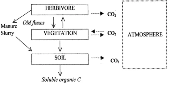
The paradigmatic carbon cycle of grassland ecosystems implies exchanges of carbon in form of organic matter among three compartments (soil, vegetation, herbivores) and under inorganic form as CO2 between each of these and the atmosphere (fig.2.1). The vegetation exchanges actively CO2 with the atmosphere through the biological processes of photosynthesis and respiration and contributes to inputs of organic matter into the soil by dead tissues that are partly decomposed and the carboncontained in released to the atmosphere as CO2. The herbivores consume grass matter, return part of
the ingested carbon through excrements, that naturally serve as fertilizing substrate for grass, and emit
CO2 to the atmosphere as a result of respiration. In managed grasslands the excreted carbon may be
incorporated directly into soil as manure by farming practices. For natural steppe ecosystems, in absence of livestock, the fraction of primary productivity consumed by herbivores, typically rodents, is very small and generally does not exceed 1-2% of NPP. Moreover, grasslands contribute to the
biosphere-atmosphere exchange of non-CO2 greenhouse gases, with fluxes tightly depending on
management practices: nitrous oxide (N2O) is emitted by soils and methane (CH4) is emitted by
livestock at grazing and can be exchanged with the soil. Moreover, horizontal transfers of organic carbon to or from grassland plots may occur as a result of harvesting grass as silage or hay, on the one hand, and of farm manure applications on the other. Up to 98% of the total carbon store in temperate