AFRICAN CULTURE COMPLEX
AFRICAN CULTURE TOWER & HOTEL
Supervisor : Prof. Maria Grazia Folli Prof. Corrado Pecora Prof. Francesco Romano Prof. Giovanni Dotelli
Prof. Lavinia Chiara Tagliabue Abduljaleel Sabo Sodangi İsmail Cem Aslan
Ugochukwu Elvis Anaka Co-Supervisors:
Authors:
ABDULJALEEL SABO SODANGI İSMAİL CEM ASLAN
UGOCHUKWU ELVIS ANAKA
Politecnico di Milano
School of Architecture Urban Planning Construction Engineering
2° level (Corso di Laurea Magistrale - Equivalent to Master of Science) - Architecture Supervisor : Prof. Maria Grazia Folli
Co-Supervisor : Prof. Corrado Pecora Co-Supervisor: Prof. Francesco Romano
POLITECNICO
DI MILANO
| 896575 | 891950 | 891798
AFRICAN CULTURE COMPLEX
AFRICAN CULTURE TOWER & HOTEL
ONTENT
ABSTRACT
CHAPTER
CHAPTER
1 - 1 Country : Nigeria 1 - 1 - 1 Geography 1 - 1 - 2 Climate1 - 1 - 3 Ethnic Diversity (Structure) 1 - 1 - 4 Ethnic Diaspora (Culture)
2 - 1 Site
2 - 1 -1 Distance Analyse
2 - 1 - 2 Current Suburban Suituation 2 - 1 - 3 Communities
2 - 1 - 4 Purpose, Aim, Approach 2 - 1 - 5
1 - 2 City : Abuja
1 - 2 - 1 Maps & Masterplans 1 - 2 - 2 Growth Demography 1 - 2 - 3 Urban Suituation 1 - 2 - 4 Problems & Critics 1 - 2 - 5 Urban Inbalance 1 - 2 - 6 Urban Case Study 1 - 2 - 7 Land Use
1 - 2 - 8 Possible Proposals & Recommendations 1 - 2 - 9 Sustainability
INTRODUCTION
URBAN CONTEXT
C
01
02
CHAPTER
03
ARCHITECTURE
3 - 1 Concept: Fulani Calabash 3 - 2 Masterplan
CHAPTER
CHAPTER
CHAPTER
CHAPTER
CONCLUSION
LIST OF FIGURES
source
source
REFERENCES
STRUCTURE
MATERIALS
BIM
BUILDING SERVICE
04
05
06
07
4 - 1 4 - 2 4 - 1 4 - 2 5 - 1 5 - 2 5 - 1 5 - 2ABSTRACT
Africa has always been a continent of lost culture and traditions. So many inspiring stories that have been neglected, it’s Art and Architecture unappreciated. Because of this there’s is very little research in Medicine, Technology, Art. This leaves the whole world at a loss since this knowledge is a contribution to global knowl-edge. Some blame it on colonialism and slave trade and the perception of Africans and especially Negro’s as an inferior race. That could have been a reason which gave room for Africans themselves neglecting their own rich culture and instead embracing foreign culture. While embracing foreign culture and methods is not a bad thing, the problem stems when culture is copied instead of being inspired from. The idea of inspiration is much stronger as it allows for stripping away unnecessary items from the source and only taking what is useful and combining it with the existing to create something beautiful. This aim of this intervention is to reawaken the passion for African Art and Architecture, using state of the Art technology and local content to pass a message that has both physical and mental value to those who belong to the culture and those wish to learn from it. In context, the country which suits best this kind of intervention is Nigeria. A country with vast Natural resources in agricultural and mineral resources that even neighboring countries depend on, but also Hu-man Resources with a population of 200 million people and over 360 languages and three times more di-alects. It’s evident that Nigeria has a lot of cultural history dating back to the early days of trans-Saharan routes. And with many Stories untold and many resources untapped, leaves room for a start of a New age. The project, which is a Culture tower and Hotel located next to the airport of Abuja, the country’s capital, will serve as an introduction to the many different resources of the country to transit passengers, visitors, residents. It would also include an educational facility where the visitors and the locals can learn native Art and crafts, a botanical garden with different fruits from all parts of the country and market place where all these crafts and products can be sold.
INTRODUCTION
1 - 1 COUNTRY: NIGERIA
Is a country in West Africa, bordering Niger in the north, Chad in the northeast, Cameroon in the east, and Benin in the west. Its coast in the south is located on the Gulf of Guinea in the Atlantic Ocean. The federation comprises 36 states and 1 Federal Capital Territory, where the capital, Abuja, is located Nigeria’s population is projected to grow from more than 186 million people in 2016 to 392 million in 2050, becoming the world’s fourth most populous country. Nigeria’s sustained high population growth rate will continue for the foresee-able future because of population momentum and its high birth rate.
01
Niger
NIGERIA : GEOGRAPHY
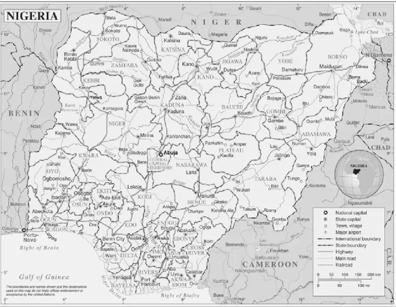
Nigeria is located in western Africa on the Gulf of Guinea and has a total area of 923,768 km2 (356,669 sq mi),[95] making it the world’s 32nd-largest country. It is comparable in size to Venezuela, and is about twice the size of the US state of California. Its borders span 4,047 kilometres (2,515 mi), and it shares borders with Benin (773 km or 480 mi), Niger (1,497 km or 930 mi), Chad (87 km or 54 mi), and Cameroon (1,690 km or 1,050 mi). It’s coastline is least 853 km (530 mi).[96] Nigeria lies between latitudes 4° and 14°N, and longi-tudes 2° and 15°E.
The Zuma Rock near Suleja
The highest point in Nigeria is Chappal Waddi at 2,419 m (7,936 ft). The main rivers are the Niger and the Benue, which converge and empty into the Niger Delta. This is one of the world’s largest river deltas, and the location of a large area of Central African mangroves.
Figure 2 : Map of Nigeria showing state boundaries,waters and highway
NIGERIA : CLIMATE
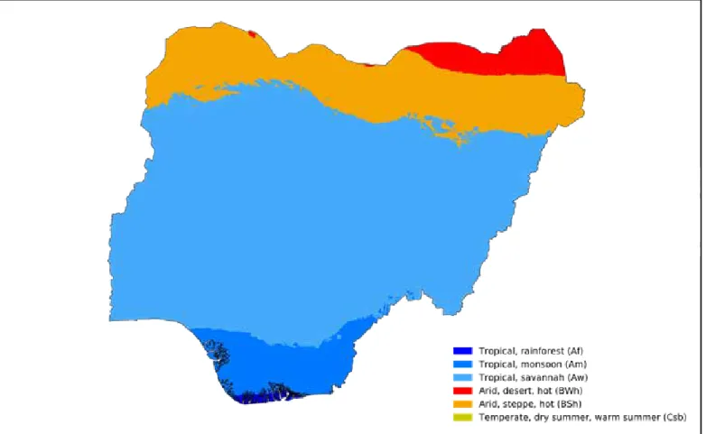
Nigeria has a tropical climate with variable rainy and dry seasons, depending on location. It is hot and wet most of the year in the southeast but dry in the southwest and farther inland. A savanna climate, with marked wet and dry seasons, prevails in the north and west, while a steppe climate with little precipitation is found in the far north.
In general, the length of the rainy season decreases from south to north. In the south the rainy season lasts from March to November, whereas in the far north it lasts only from mid-May to September. A marked inter-ruption in the rains occurs during August in the south, resulting in a short dry season often referred to as the “August break.” Precipitation is heavier in the south, especially in the southeast, which receives more than 120 inches (3,000 mm) of rain a year, compared with about 70 inches (1,800 mm) in the southwest. Rainfall decreases progressively away from the coast; the far north receives no more than 20 inches (500 mm) a year. Temperature and humidity remain relatively constant throughout the year in the south, while the seasons vary considerably in the north. The humidity generally is high in the north, but it falls during the harmattan (the hot, dry northeast trade wind), which blows for more than three months in the north but rarely for more than two weeks along the coast.
Figure 3: Köppen-Geiger Climate Classification Map of Nigeria (1980-2016)
NIGERIA : ETHNIC DIVERSITY (STRUCTURE)
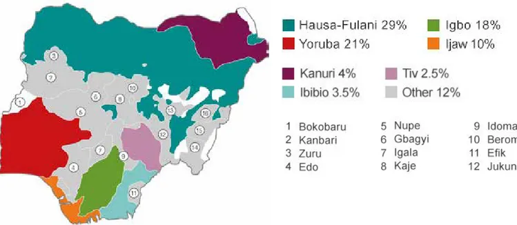
Nigeria is Africa’s most populous country, is composed of more than 250 ethnic groups. The country is a mo-saic of many ethno-linguistic groups, some large, many very small indeed, altogether numbering about 250 to 400,The architecture of Nigeria at amalgamation comprised two entities: the Northern and Southern Protectorates. Each of these Protectorates contained large numbers of ethnic and linguistic groups, some large, some small, some not aware of their neighbours; some were organized prior to colonization into kingdoms, states, provinces or outposts of other power systems, while some were entirely clan based with little awareness of far-flung parts of the same ethnic and linguistic group so that amalgamation was in some cases a first step in bringing together the different clans of the same ethnic and linguistic group to a sense of a shared identity. The common myth is that Nigeria has 250 ethnic groups. Some estimates put the number at over 400 [cf. Bangura, nd]. The sociologist, Onigu Otite, has provided a list of 374 ethnic groups [Otite, 1990]. There is common agreement, however, that these ethnic groups are broadly divided into ethnic ‘majorities’ and ethnic ‘minorities’. The numerically – and politically - major ethnic groups are the composite Hausa-Fulani of the north, the Yoruba of the southwest, and the Igbo of the southeast. These three ‘hegem-onic’ ethnic groups are popularly referred to by the generic term ‘wazobia’. Centres of large population con-centrations coincide with the homelands of these three majority ethnic groups who constituted 57.8% of the national population in the 1963 census [Afolayan, 1978; 147 & 155]. That census has the Hausa at 11,653,000 (20.9%), the Yoruba at 11,321,000 (20.3%), and the Igbo at 9,246,000 (16.6%) [Jibril, 1991, 111]. All the other ethnicities constitute different degrees of ‘minority’ status. There are ‘large minorities’ like the Ijaw, Kanuri, Edo, Ibibio, Nupe, and the Tiv. Eleven of such largeminorities constituted 27.9% of the population in the 1963 census [Afolayan, 1978;
Figure 4: Major Etnic Groups ( % of population )
NIGERIA : ETHNIC DIASPORA (CULTURE)
Nigeria hs vast population and concentrated ethic groups with different culture and belief system. However there are major, minor and much smaller ethic groups.That census has the Hausa,the Yoruba, and the Igbo. All the other ethnicities constitute different degrees of ‘minority’ status. There are ‘large minorities’ like the Ijaw, Kanuri, Edo, Ibibio, Nupe, and the Tiv. These groups have their unique arts and tradition
HAUSA AREWA YORUBA TWINS IGBO ADAMMA
BENIN BRONZE MASK
KANURI CALABASH URHOBO IPHRI
FULANI CALABASH
BENIN BRONZE MASK IBIBIO MASK
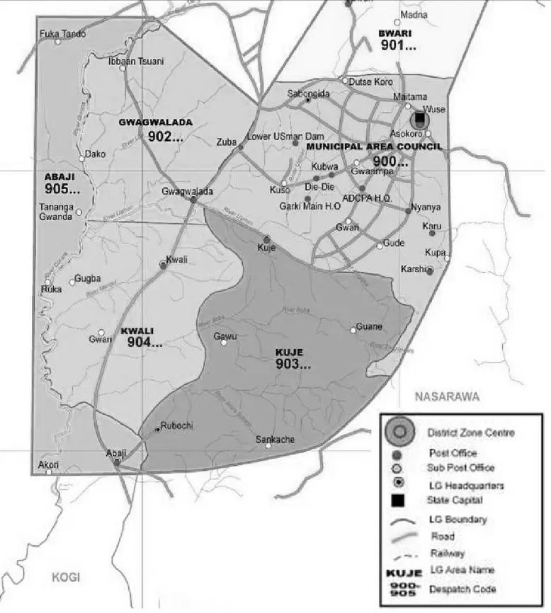
CITY: ABUJA
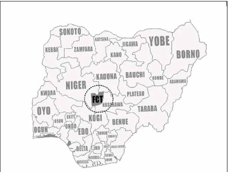
Figure 14: Location of Federal Capital Territory in Abuja
Source :
Abuja is the capital of Nigeria. It replaced the former capital, Lagos, as the capital city in 1991, although Lagos remains the most populous city.
Once Nigeria declared its independence, it was decided that a capital would be created that would unite the ethnicities and religions of the country. The location was selected during the 1970s.
The master plan for Abuja and the Federal Capital Territory (FCT) was developed by International Planning Associates (IPA), a consortium of three American firms: Planning Research Corporation; Wallace, McHarg, Roberts and Todd; and Archisystems, a division of the Hughes Organization. The master plan for Abuja de-fined the general structure and major design elements of the city that are visible in its current form. More detailed design of the central areas of the capital, particularly its monumental core, was accomplished by Kenzo Tange, a renowned Japanese architect.
ABUJA: MAP & MASTERPLAN
Figure 15: Maps of Federal Capital Territory
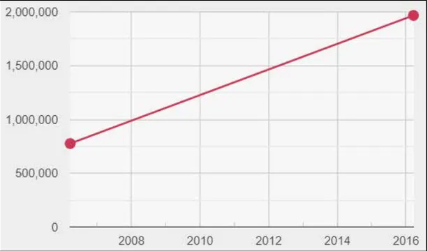
ABUJA: GROWTH DEMOGRAPHY
Figure 16: Growth Demographic Chart
Source :
The city of Abaja is one of the only planned cities in Africa, and judging by its massive population growth, it is one of the most successful. The city is home to multiple religious sites and centers, including the Nigerian National Mosque.Abuja is one of the wealthiest cities in Africa.The city’s population is extremely diverse, and groups that reside here include Afo, Gwari, Hausa, Koro and Bassa, just to name a few. The official language of the city is Enlish, although other languages are spoken, including Ibo, Fulani and Yoruba. Approximately-half of the city’s residents are Muslim, 40% are Christian, and the remainder have follow other religions. Abuja Population Growth
Abuja is one of the fastest growing cities in the world, with a population that already is climbing to 2.5 mil-lion since its development in the 1980s. During theearly 2000s, the city’s population grew by almost 140%. Today, most areas of the city still see annual growth of 35%, making it one of the fastest-growing cities in the world. Because of the city’s reputation for being welcoming to all groups, no matter their ethnicity or religion, the population is only expected to continue to grow for Nigeria’s capital city. The last census taken in 2006 put the population at 776,298. However, between 2000 and 2010, the population grew by almost 140%, with more recent estimates showing that the population now exceeds 2.4 million.
ABUJA: URBAN SUITUATION
The questions are, who are the people mostly affected by the poor implementation of the Abuja Master Plan, Abuja demolitions and, the high cost of securing housing accommodation in Abuja and its territory? According to Bamidele (2010), most of the workers who cannot afford to live within the city, find their way to the squatter settlements and uncompleted or abandoned buildings within the city which punctuated all high-brow areas of the city and many The people, according to Uji and Okonkwo (2007), frustrated by the in-adequacies and failure of the conventional approaches to provide urban shelter and services to a significantly large enough proportion of the poor in the urban areas of the developing nations, these ever-increasing class of urban populations have to resort to squatting on public or private land, either by invading and forcefully occupying or leasing such land (illegally sub-divided) on which they hurriedly construct (through self-help) their shelter from any available materials using any readily affordable and available technology.
The government’s approaches have not necessarily, extensively reviewed and investigated the ancestral con-cerns of most of the residents of the Abuja urban poor communities. A lot of government’s solutions are centered on quick-fix urban renewal programmes that have not in anyway, helped the course of the urban poor communities and settlements in Abuja metropolis. The demolition exercises (several), resettlements and land swaps programmes adopted by the governments have added more frustrations to the Abuja urban poor problems instead of solving them.
Almost all the government housing programmes have failed to address the housing needs of the urban poor, especially, the Abuja urban poor housing demands. Keeping and maintaining the government’s failed, ortho-dox housing delivering schemes to the expanding poor Nigerian populations, how can the government, sus-tainably, provide where the urban poor can live without disturbing the urban equilibrium, knowing that they (the urban poor) have no lands, that they squat anywhere they see and provide services needed to maintain the rich communities. Lack of accommodation has become the bane of most Abuja residents. During the Mallam Nasir el-Rufai administration of the Federal Capital Territory (FCT), many residents of Abuja lost their houses to the demolition exercise. That incident, however, contributed to the high cost of securing accom-modation in the city center and even in the satellite towns. The influx of people into Abuja to look for greener pastures has helped to worsen the situation. To the average civil servant, securing a befitting accommodation in the FCT, irrespective of its location, is not only a challenge, but also an uphill task. Decent accommodation has continued to constitute a big problem to Abuja residents. Houses located at Garki, Maitama, Asokoro, Wuse, Jabi and Utako districts are practically beyond what the middle and low income earners can afford. That resulted to concentration of squatter settlements in the Federal Capital Territory.
ABUJA: URBAN INBALANCE
ABUJA: URBAN CASE STUDY
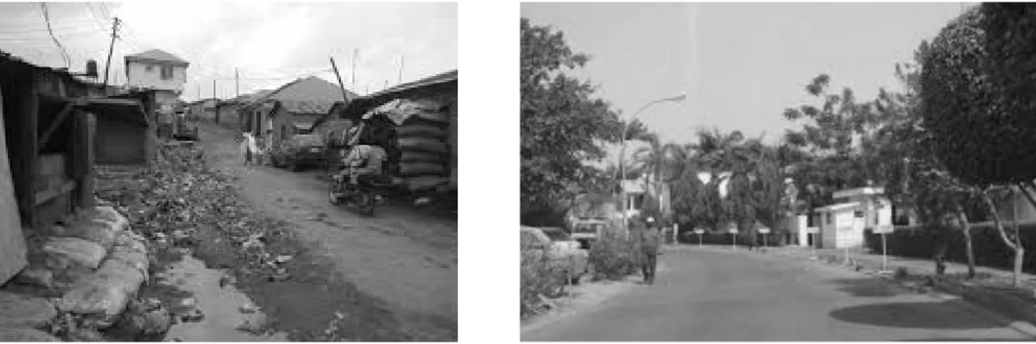
Kuruduma community in Asokoro
The Story of Koroduma, the Slum near Asokoro in Abuja, Nigeria, where Opulence meets Squalor, Odinaka (2017), indicated that, it is a tale of striking ironies. Opulence on one side, squalor and debilitating poverty on the other side. That is the story of Koroduma, a slum near the highbrow Asokoro in the Federal Capital City of Abuja, Nigeria Undoubtedly, there are scores of slums in Abuja, but Koroduma stands out for its heart-rending narrative. The United Nations Human Settlements Programme (UN Habitat) in Nigeria has stated that about 80 million Nigerians, representing 79 per cent of the population, are living in slums. Growth of informal settlements are on the increase in the FCT. This is largely as a result of inadequate, unaffordable housing for all classes of the citizenry. The challenges of securing land tenure for the teeming populace, the high cost of building materials, inaccessible mortgage mechanisms for the poor as well as the high rents of urban accommodation have been responsible for the mushrooming of many of the city’s suburban slums. To get to Koroduma village, one needs to get to the “Asokoro AYA,” where tricycle-lists line up for their turns to the bus stop called Kasangari. There, one would be greeted by hundreds of makeshift shacks, most of them made of mud, roofed with rusty zinc sheets.The settlement, like every other village, despite the obvious cha-os in the structures, has leaders and a system of law and order. One feature of the village that stands out is its landscape. Roads are dusty and narrow.
The image above clearly shows the extent of urban and Architectural disconnect in one area due to negli-gence of professionally established policies and bad governmance .
Figure 23-24: Amenities/Environmental Urban constrast between Asokoro and Kuruduma village (In Asokoro) .
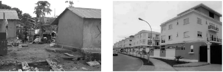
ABUJA: URBAN CASE STUDY
Kuruduma vs Asokoro in light of Housing suituation and Economic performance
An apartment built either with mud or cement costs between N100,000 and N150,000 in rent compered to millions of Naira paid in properly surveyed areas in AsokoZro and other parts of the Abuja city. The residents seem to have come to terms with their community and see nothing wrong with their garbage-infested envi-ronment. It is a place that would always command attention and elicit questions such as what are the possi-ble solutions to revitalise the unhealthly condition of this community.
Adiukwu (2014), in his Prospects and Challenges of Informal Settlements and Urban Upgrading in Abuja, indi-cated that, poverty has a social dimension (poor quality of housing and the living environment, i.e. lack of ac-cess to basic services like clean water, health care, education etc.). Abuja is one of the most rapidly urbanizing cities in Africa, faced with challenges of squatter settlers. The shelters are, built by the efforts of the squatters who cannot afford to secure legal or formal land or a safe site on which a house can be, built. Informal land developments provide shelter for over 85% of the population of urban residents in most developing Nations (UNCHS, 1996 and 2000; Durand-Lasserve, 1997). Urban Poverty,citing Copenhagen resolution (2000), is strongly associated with high levels of environmental risk. This is largely due to poor quality and overcrowded housing conditions and the inadequacies in provision of water, sanitation, drainage, health care, garbage/ waste collection, poor percolation resulting into flood, building on waterways and pollution of land, air, and water. Daramola and Ibem (2010) affirmed that the concentration of more people in urban areas has brought more pressure on the land space for the production of food, infrastructure, housing, and industrialization. The movement affects the capacity of the environment to cope, as each additional person increases the de-mand on the infrastructure and the natural system and as result creating ecological imbalance with adverse environmental penalty in hazards and disaster.
Figure 25-26: Housing Urban constrast between Asokoro and Kuruduma village (In Asokoro) . The image above clearly shows the extent of urban and Architectural disconnect
ABUJA: LAND USE
Abuja was declared the new capital city of Nigeria in 1976, due to overpopulation, shortage of land for urban expansion, distortion of the master plan, and traffic congestion, in the formal capital Lagos. By contrast, Abu-ja featured availability of space for urban development, a central location to provide almost equal access to the different ethnic groups across Nigeria, and an ethnically neutral territory . The FCT Abuja was carved out from four states. The seat of government was officially relocated to FCT Abuja in 1991 and since then the re-gion has witnessed a high rate of urban growth . The population of FCT Abuja was 1,406.239 million in 2006 . Based on the 2006 population, we estimate the population of FCT Abuja to be 3,770,376 million in 2017. This population expl sion and the accompanying sprawl has led to pressure on the surrounding natural resources causing loss of other land uses in the region.
Figure 27: Most developed areas of Abuja city
ABUJA: LAND USE
Figure 28: Proposed four phases of Abuja city and areas
Source :
In 1979, the Abuja master plan was prepared to comprise regional and urban land use plans The regional land use plan covers the FCT Abuja, while that of the urban land use plan was limited to the city, Abuja, and was divided into four phases. The four development phases included 5, 15, 19, and 29 districts, respectively . Phase 1 included the central district (planned for the governmental seat of power and the Central Business District), and four other residential districts ,Additional urban land use plans for the satellite settlements were separately designed . However,through field surveys, we observed that the urban land use plans for the satellite settlements have not been implemented in most areas. These areas are currently characterized by informal settlements. The purpose of the Abuja land use plans included the designation of areas for urban land uses, the preservation of the natural environment, improved accessibility of all areas , coordination of land use, etc. Monitoring of urban expansion and updating of land use plans are challenged by rapid urban growth and especially by the development and expansion of informal settlements in peri-urban/satellite settlements in the city-region. In Abuja city, urban land uses expanded from a few development districts to create some urban extensions. Vegetation, which is another important land cover in the Abuja city-region, is similar to that of other parts of FCT Abuja. The vegetation is categorized under the West African ecoregion of Guinean Forest-Savannah mosaic. Due to the location of the Abuja city-region in the northern part of FCT Abuja, the area is dominated by the savannah vegetation, which is characterized by deciduous trees that are scattered among grasses .
ABUJA: LAND USE
Calculated area of land cover of Abuja in 1987, 2002, and 2017.
Land Cover classes 1987 2002 2017
Urban/built-up 36.8 (1.8%) 198.8 (10.0%) 385.4 (19.3%) Vegetation 1455.6 (73.0%) 1262.5 (63.3%) 1011.9 (50.8%) Bare land 491.9 (24.7%) 522.1 (26.2%) 588.6 (29.5%) Water 9.3 (0.5%) 9.6 (0.5%) 7.7 (0.4%) Total 1993.6 (100.0%) 1993.0 (100.0%) 1993.6 (100.0%)
Figure 28: Land cover of Abuja city-region in 1987, 2002, and 2017
ABUJA: LAND USE
Figure 29:The regional land use plan of the Abuja city-region.
Figure 29:The regional land use plan, with urban expansion trends overlaid for visual comparison.
Source :
Source :
The regional land use plan indicated that the area designated for urban development are primarily within Abuja city, with urban extensions in the peri-urban/satellite settlements. In the southern part of the gion, the area designated for urban development for Abuja city extends beyond the boundary of the city-re-gion.
ABUJA: LAND USE
Figure 31:The regional land use for urban development and urban expansion into other land uses.
Figure 32: Percentage of proposed land uses lost to urban/built up and urban expansion trends
Source :
Source :
The past and current urban expansion encroached into the proposed land use for intensive agriculture, an-imal husbandry and protected areas. The protected area lost to urban/built-up in 1987, 2002, and 2017 are 0.92 km2, 6.84 km2, and 16.65 km2, respectively. In 1987, 2002, and 2017, the proposed land use for inten-sive agriculture lost 3.73 km2, 18.98 km2, and 34.91 km2, respectively, while that of animal husbandry lost 0.16 km2, 1.16 km2, and 3.59 km2 to urban/built-up. From 1987 to 2002 and from 2002 to 2017, the ACR of the protected areas lost to urban/built-up is 0.39 km2 and 0.65 km2 per year. The ACR of the proposedland use for intensive agriculture lost to urban/built-up is 1.02 km2 from 1987 to 2002 and 1.06 km2 from 2002 to 2017 per year, while that of animal husbandry is 0.07 km2 and 0.16 km2 from 1987 to 2002 and from 2002 to 2017.
ABUJA: SUSTAINABILITY
The Three Pillars of Sustainability
In 2005, the World Summit on Social Development identified three core areas that contribute to the philoso-phy and social science of sustainable development. These “pillars” in many national standards and certifica-tion schemes, form the backbone of tackling the core areas that the world now faces. We must consider the future then, in making our decisions about the present.
Economic Development
Economic development is about giving people what they want without compromising quality of life, especial-ly in the developing world, and reducing the financial burden and “red tape” of doing the right thing. Also, to encourage and foster incentives for the average person to do their bit where and when they can; one person can rarely achieve much, but taken as a group, effects in some areas are cumulative. The supply and demand market is consumerist in nature and modern life requires a lot of resources every single day; for the sake of the environment, getting what we consume under control is the paramount issue.
Social Development
It is also about maintaining access to basic resources without compromising the quality of life. The biggest hot topic for many people right now is sustainable housing and how we can better build the homes we live in from sustainable material. The final element is education - encouraging people to participate in environmen-tal sustainability and teaching them about the effects of environmenenvironmen-tal protection as well as warning of the dangers if we cannot achieve our goals.
Environmental Protection
We all know what we need to do to protect the environment, whether that is recycling, reducing our power consumption by switching electronic devices off rather than using standby, by walking short journeys instead of taking the bus. Businesses are regulated to prevent pollution and to keep their own carbon emissions low. There are incentives to installing renewable power sources in our homes and businesses. Environmental protection is the third pillar and to many, the primary concern of the future of humanity. It defines how we should study and protect ecosystems, air quality, integrity and sustainability of our resources and focusing on the elements that place stress on the environment. It also concerns how technology will drive our greener future; developing technology and biotechnology is key to this sustainability, and protecting the environment of the future from potential damage that technological advances could potentially bring.
SITE: DISTANCE ANALYSIS
Figure 33: Distance Analysis from project site into the main city of Abuja
Source :
The project site is located 8kms away from the city international airport,15kms away from rail line and 35kms away from the city .Also around the project site are smaller rural communities,farm lands and military base.
URBAN CONTEXT
SITE: CURRENT SUBURBAN SUITUATION
The airport/military district is a sub urban region which through our project and proposal will regenerate and improve the current livelihood of dwellers of this region.however the inhabitants of this region is considered low income earners and lacks proper infrastructure to aid quality living, hence the language Urban regener-ation. The settlers of these various communities in this region expresses and practices a certain lifestyle as regards to business, ethnic belives,arts and security.Their major means of livelihood boarders of Agricultural produce mud art and wood crafts. However,in recent times these communities have experienced some level of economic burst following the establishment of an airport and major raod route linking the airport to other more developed cities hence providing opportunity to sell their agricultural produce and home made crafts to travellers.
As shown in the images,These smaller communities display and sell their agricultural produce and wood crafts on a major highway with the aim of selling to travellers . Our proposal will however bring a positive and sustaintable turnaround in terms of social development, Economic development and environmental protection.
SITE: PURPOSE, AIM, APPROACH
Having understood the sub urban way of life,needs and their social class in the econocomic and urban context at diffferent scales, it is paramount to underlay in details the foreseen improvement the proposed project will drastically induced in this region,also approach and scientific methods adopted to ensure the realization of goal as regards to the project.
AIM
• To revive a highly potiential but static environment • To improve quality of life
• To equalize the urban imbalance between this region and the main city • To drive innovation on both local and international scale
REVIVAL CONSIDERATIONS • Infrastructure
• Financial Empowerment and Awareness
• Access to quality healthcare,education and services • Affordable housing
APPROACH
• Inclusive urban redesign (consideration of all social classes)
• Integrated architectural design to achieve better building behaviour • Use of traditional materials which are cost effective and readily avaliable Improve Economic Situation
Attraction Point Agricultural Products African Culture Safety Environment
URBAN CONTEXT: PROJECT PROPOSAL
African Culture Complex
we would like to provide people with the experience of African culture during their visit. There has also been the argument of stolen artifacts by Colonialists (British, etc) on whether they should be returned or not. Recently, proposals have been made as to whether they should be returned unconditionally or loaned back to Nigeria. So we would like to design an African Culture tower (a tall building) that will have a museum that these artifacts can be returned and an African themed spa hotel which services the traditional experiences about Africa. This tower will contain different activites including museum,conference rooms,restraunt, inter-esting architectural elements such as high windows, ramps and so on which will aid in giving interestin views and utmost intimate experience.
Most importantly this project will be executed using readily available and traditional building materials which are Red clay and bamboo.The project aim to meet across the globe creating the awe sense of feel of originali-ty and geniuenioriginali-ty of a dwindling culture and tradition through the maginfying lens of architecture, we intend to create through this project a deep level of intimacy between these buildings and the guests
The desired construction technique for this project is the use of the 3d clay printing machine and wiil will done on site.
SITE: CONTEXT
Following the instensive study of Abuja and the site location of the project, It is imperative go gradually and logically develope a masterplan that best suites the project, the users and the environment.
Stage 1, Acknowleging the presence of the water body and planning activities to flow in linar manner
Stage 2 creation of master plan in 3 linar directions Market place, Hotel/botanical Garden and Arts/crafts district
Art & Craft District
Culture Complex & Green Zone
SITE: CONTEXT
stage 3, Defining the urban pattern ınto zones
stage 4, Introduction and planning of the Arts/craft district and Marketplace district following the historic and traditional settlement pattern
SITE: CONTEXT
stage 5, Introduction and planning of the botanical garden in a very fluid and organic pattern
URBAN PLAN
Art & Craft District
Culture Hotel
Marketplace
Culture Tower
Botanic Garden
ENVIRONMENTAL CONSIDERATION
Given the gblobal issue of carbon print/Global warming which threatens the eco systems and environment at large, we are compelled by ethics of research to think in a more sustainable dimension as how we can through our project mitigate or reduced the existance these threat .This very much influenced the choice of materials to be used both on the building and landscape. In Nigeria the CO2 emissions per capita for was 0.44 metric tons as a result of burning fossils and manufacture of cement.They include carbon dioxide produced during consumption of solid, liquid, and gas fuels and gas flaring. And so to reduce the carbon footprint in and around the project area, we propose to have a BOTANICAL GARDEN and GREEN WALL which includes varieties of trees,fruits and flowers also we choose to use more sustainable materials like clay and bamboo. Clay as a building material provided by nature has
nu-merous advantages for which energy efficency is one of many.
Bamboo as a natural composite material is energy ef-ficient ,sustainable and self reliance.
Plants flowers absorbs Co2 for sugar and oxgygen pro-duction
through celluare respiration.
The Green wall serves as natural air-filtration system
and Noise/wind barrier.
The Botanical Garden in our project serves various unique purposes all at once which includes restoring ecosystems,provide knowledge on biodiversity and promotes human to nature relationship on the great-er scale which defines the one of the numbgreat-erous re-search ethnics in our project from the enviromental point of view.
Vegetation
The Botanical gardern contains varieties of fruits and flowers which is accessible to all guests .Here are some of the local fruits in the botanical gardern
CONCEPT : FULANI CALABASH INSPIRATION
These images of women signify the typical fulani woman carrying a calabash of cow’s milk, which is a very popular drink in Nigeria. The way in which they carry the calabashes in stacks on their look-ing like a tower is what is inspirlook-ing. They carry them for long distances and have perfected the art of stability over time. In Some cases they use a system of ropes to bind them together. the ropes are made from palm leaves. They usually first place a support which in this case we can refer to as a “plinth” that is usually textile wrapped in the shape of a donut. which normalizes the curvature of carrier’s head and the calabash base, then sub-sequent calabashes are stacked on each with a flat disc covering called “marufa” made from straw.
ARCHITECTURE
03
The Calabash itself is made from the fruit of the calabash tree which is popular in tropical regions around the world. When the fruit is harvested, its cut open in half and the juice and seeds are scraped off from the shell and used as drinks or for medicinal purposes. The shell however, is left to dry and then decorated with variety of designs. Some of them tell stories of the user’s or their tribes. it is resistant to degradation from moisture and very stable. Because of this it can be used to store liquids and food.
The fulani people are nomadic people who have established routes for over 200 years and trav-el all across the equatorial region of africa from West- Central -and East. Fula are primarily known to be pastoralists, but are also traders in some ar-eas. Most Fula in the countryside spend long times alone on foot, moving their herds; they were the only major migrating people of West Africa. Tak-ing from the calabash inspiration we designed our tower in this form. With this we took inspiration
African Culture Tower
African Culture Hotel
AFRICAN CULTURE COMPLEX
In the form of building, from the bottom to top, the circular visiting route orients people to follow it in inte-rior spaces and exteinte-rior spaces by ramps. So, in this route, people see the African Culture by the exhitions inside and by the landscape outside. Route starts with museum, conference area and continue with library and exhition area. Then after the ramp walking in sense of form of building, it finishes with traditional african kitchen in restaurant and clear viewpoint in terrace floor at the top of the building.
A part of to know the African Culture is a new way to host people. The Culture Hotel buildings are in different garden for privacy but close to Culture Tower for easy accesssible. They designed into low stories to feel close to garden and includes traditional African massage service to experience the African Culture in third, another different way.
MASTERPLAN
CULTURE HOTEL
CULTURE TOWER
Ground Floor Plan
Section N-S
SERVICE LIFT
Section W-E
SERVICELIFT
B
FLOOR PLANS
First Floor : MUSEUM
Thirth Floor : MUSEUM
Fifth Floor Plan : CONFERENCE
Seventh Floor : EXHIBITION
Ninth Floor : RAMP
Eleventh Floor : RESTAURANT
Basement Floor : SERVICES
DETAILS
Detail 3 - Roof
55
1 - COUPLE ROOMS
2 - LARGE ROOMS
-1 - SERVICES
SITE PLAN
AFRICAN CULTURE COMPLEX
Politecnico di Milano
Supervisor : Prof. Maria Grazia Folli
Authors : Abduljaleel Sabo Sodangi
| 896575
African Culture Complex - Hotel & Tower
CULTURE HOTEL
Section & Ground Floor Plan
A part of to know the African Culture is a new way to host people. The Culture Hotel buildings are in different garden for privacy but close to Culture Tower for easy accesssible. They designed into low stories to feel close to garden and includes traditional African massage service to experience the African Culture in third, another different way.
HOSTING
MASSAGE HOSTING
Second Floor Plan
STRUCTURE
04
CLAY STRUCTURE: 3D PRINTING CLAY PANEL
EXPLODED STRUCTURAL LAYERS
CLAY PANEL ASSEMBLY
PANEL CROSS SECTION STEEL CONNECTION ELEMENT
STEEL BAMBOO CONNECTION
mm E-3
Bamboo-Clay wall
Connection Clay Wall Panel Loads Displacement Values = Dead Load (Bamboo) + Panels + Wind (1KN) Wind Load (1KN) Support Points
mm
To Simplify the structural analysis, The bamboo shoots were considered as one (1) with diameter 350mm and thickness 15mm instead of two (2) with diameter 300mm and thickness 10mm
Facade Structural Analysis
mm E-3
Bamboo-Clay wall
Connection Clay Wall Panel Loads Displacement Values = Dead Load (Bamboo) + Panels + Wind (1KN) Wind Load (1KN) Support Points
mm
Facade Structural Analysis
Bamboo - Clay Wall Connection Clay Wall Panel LoadsDisplacement Values = Dead Loads (Bamboo ) + Panels + Wind To Simplify the structural
anal-ysis, The bamboo shoots were considered as one (1) with diam-eter 350mm and thickness 15mm instead of two (2) with diameter 200mm and thickness 10mm
mm E-3
Bamboo-Clay wall
Connection Clay Wall Panel Loads Displacement Values = Dead Load (Bamboo) + Panels + Wind (1KN) Wind Load (1KN) Support Points
mm
Facade Structural Analysis
Wind Load ( 1 kN )
ROOF STRUCTURE ASSEMBLY
1. Base
3. Bamboo Strips Direction-A
5. Bamboo Strips Direction-C
4. Bamboo Strips Direction-B
6. Second Layers of Directions A-B-C 2. Boundaries
ROOF TEXTILE
MATERIALS
05
The significance of solid mineral resources has been ofprofound value to man since time immemorial. Clay minerals appear not to be the most valuable among the minerals of the earth surface, yet they affect life on earth in far reaching ways. Nigeria in sub-Saharan Africa (surface area: 923,768 km2) is a country with con-siderable wealth in natural resources, with a record of over 30 minerals of proven reserves . As far back as 1903 and 1904, geological survey in Nigeria evolved when the Mineral Surveys of the Southern and Northern Protectorates of Nigeria were established under the British colony. The Mineral Surveys carried out broad re-connaissance of mineral resources of the two Protectorates with the prospect of using the raw materials for industries in Britain. In course of these activities, such deposits as Tinstone, Columbite Limestone, Bitumen, Lead-zinc Ores, Coal, Clays, Iron Ore, Gold, and Marble etc were discovered in various parts of the country.Af-ter the colonial era, government parastatals have been set up such as the Nigeria’s Ministry of Solid Minerals Development, Raw Material Development Research Council (RMDRC) and the Federal Institute of Industrial Research Oshodi (FIIRO) which all tried to establish a comprehensive data list of basic mineral resources as they occur at various geological locations in appreciable millions of tonnage that supports experimental and industrial uses .In recent research purview, various studies on solid mineral resources using geo-scientific sur-veys and mineralogical charaterisation considered that the understanding of the nation’smineral potentials is critical for efficient exploration and exploitation towards promoting sustainable economic developmentas shown in . Results have shown that Nigeria’s geosphereis enriched with a wide range of both metallic and non-metallic minerals deposited across the states of the nation which are and could still be beneficiated to provide the raw materials for industrial manufacturing among other productive purposes. Noteworthy, clay minerals constitute over 50% of the non-metallic, earthy and naturally-occurring resources abounding throughout Nigeria’s sedimentary basins and on the basement it was observed that extensive investigation has been carried out on the liquid mineral endowment of the country, while little has been done to solid mineral endowment of which clay is prominent and as a result, adoption of solid mineral on industrial scale is scanty.
Mararaba-Rido and Kachia areas of Kaduna State are among the largest reserves of clay deposits in Nigeria with over 5.3 million tons. Despite the vast potentials, clay minerals are still grossly underutilized and the few pockets of existing clay-based industries have primarily harnessed the raw for the production of ceramic wares and structural products.A growing number of investigations carried on the solid industrial minerals in Nigeria have been broad based and genericwith consideration for geological survey and mineral characteri-zation [see 1,4,6,8]. Besides, documented studies on clay minerals in selected areas of Nigeria tend to focus more on the mineral characterisation and with little emphasis on the economic potentials or usage of the minerals as such in . This study had considered the industrial potentialities in addition to the properties study of clay mineral using Kaduna State of Nigeria as a case study. The qualities of clay found determine its appli-cation and suitability for ceramic products such as in bricks, ceramic wares, and refractory. The findings of the study were gathered through field surveys with documentation of relevant information on clay reserves, mineral locations, and the economic significance of the minerals. This includes detailed evaluation of report findings from three clay-based industries at Mararaba-Rido, Jacaranda and Maraba areas in Kaduna State, Nigeria. The result shows a significant usage of clay mineral as a principal raw material for ceramic manufac-turing such as structural, refractories, and whitewares products. Clay minerals hold high material value to in-dustriesin Kaduna utilizing them for ceramic purposes towards socio-economic and industrial development. This supports the main policy thrust of the economic reform program of the Nigerian government which is
The most abundant, ubiquitous, and accessible material on the earth crust is clay]. Reference observed that a great emphasis is placed on exploiting the abundant solid minerals endowments in Nigeria with a view to di-versifying the economic base of the country, improving Gross Domestic Product (GDP) and industrial activity. One of these endowments with tremendous potential for economic utilization is clay. Clay deposit is spread across the six geo- political zones of the country .Clays have their origin in natural processes, mostly complex weathering, transport, and deposition by sedimentation within geological periods.
The abundance of the clay minerals in Nigeria supports its rich and historic traditional pottery industry that dates from the Stone Age. Archeological evidences from the ancient pottery areas of Nigeria such as Iwo-El-eru near Akure in Ondo State, Rop in Plateau state, Kagoro in Kaduna State and Afikpo in Ebonyi state proved that as far back as the late stone age, the occupants of these areas made productive used of clay for pottery. The composition of clayeyand organic materials such as straws made into adobe brick, served as a ubiqui-tous building material widely used for building weather-friendly housesin thevast rural domains. Modern industrial uses of clay for ceramics and bricks now obtained in notable parts of the country including Kaduna, Northern Nigeria.
Clay is simplydefined as earth or soil that is plastic and tenacious when moist and that becomes permanently hard when baked or fired. It consistsof a group of hydrous alumino-silicate minerals formed by the weath-ering of feldspathic rocks, such as granite. Individual mineral grains are microscopic in size and shaped like flakes. This makes their aggregate surface area much greater than their thickness and allows them to take up large amounts of water by adhesion, giving them plasticity and causing some varieties to swell (expandable clay). Common clay is a mixture of kaolin, or china clay (hydrated clay), and the fine powder of some felds-pathic mineral that is anhydrous (without water) and not decomposed. Clays vary in plasticity, all being more or less malleable and capable of being molded into any form when moistened with water. The plastic clays are used for making pottery of all kinds, bricks and tiles, tobacco pipes, firebricks, and other products. The commoner varieties of clay and clay rocks are china clay, or kaolin; pipe clay, similar to kaolin, but containing a larger percentage of silica; potter’s clay, not as pure as pipe clay; sculptor’s clay, or modeling clay, a fine pot-ter’s clay, sometimes mixed with fine sand; brick clay, an admixture of clay and sand with some ferruginous (iron-containing) matter; fire clay, containing little or no lime, alkaline earth, or iron (which act as fluxes), and hence infusible or highly refractory; shale; loam; and marl
Lightweight fiber-reinforced clay as a sustainable material for disaster resilient architecture of future build-ings
The LRC material introduced in this section is basically consisted of clay, with a small percent of concrete foam to increase its porosity, resulting in decreased density, and also a small percent of either of the rein-forcing materials, including gypsum, plant fibers, wood fibers, and also natural hair strands. The foam can be of synthesized or natural base. Natural foam can be made of horn and nail and some other abdominal lefto-ver materials of the livestock, which can be provided form slaughter houses. The hair, which can be human hair or hair of any animal, can be provided from the waste of haircut shops, or the farms where the hair of animals, such as goat, are cut annually. first, the mechanical properties of LRC, which have been obtained through a set of laboratory bending tests, are presented. Then, the ‘foamed hair-reinforced clay’, which has superior advantages over other types of LRC is introduced, and the results of its shear and compression tests are presented, and finally its usage as a building material for achieving sustainable and resilient architecture of future buildings, or even upgrading the existing buildings for increasing their resilience.
Bending test
For bending tests, presents geometric specifications and average mechanical properties of the samples of the five materials used in the bending test for comparison. It can be seen in that the LRC sample with nat-ural hair reinforcement, namely ‘foamed hair-reinforced clay’ (FHRC) has behaved much better than other samples in bending. In fact, all other samples have shown a brittle behavior in bending, while the FHRC has shown very high ductility and integrity. Also, it is seen in Table 1 that the FHRC has presented a bending strength the bending strength of the LRC with that special reinforcing material.
Specifications of the five materials used and obtained from the bending test.
FHRC as an innovative material
Past studies have shown that the human hair is very durable and can last for centuries (Lubec et al., 1987). Furthermore, it has been shown that adding a few percent of human hair to clay can remarkably increase the mechanical properties and decrease the thermal conductivity of clay (Jubran, Habali, Hamdan, & Zaid, 1988). In an experimental study by Ziegler, Leshchinsky, Ling, and Perry (1998), it has been shown that the inclusion of randomly distributed short fibers in the clayey soils can prevent effectively the development of desiccation cracks. Their test results have also shown that the fibers increase the tensile strength of the clay and provide a ductile behavior that was not present in the samples without fibers.
Direct shear test of FHRC and plain clay samples
Since in bending test it was revealed that the FHRC has very high efficiency comparing to other samples, it was decided that for shear test only samples of FHRC are compared with samples of plain clay. The shear tests were of the direct shear type, and were conducted on two samples of each material.
Compression test of FHRC samples
The last series of tests conducted on the FHRC samples were compression test. The samples for this test were of cube form with base dimensions of 4.9 cm and height of 3.0 cm. A sample of FHRC at the final stage of the compression test, and also after the test under the bending effect.
A sample of FHRC at final stage of the compression test (left), after unloading (middle), and after unloading under bending effect (right).
Advantages of FHRC
. Low cost
. High bending, shear and compressive strengths . Sustainability and eco-friendliness
. Ease of accessibility
. High workability and mouldability . Low density and high ductility/integrity . High fire resistance
. High heat and sound insulation
. Higher moisture resistance comparing to plain clay
Using the FHRC material in building components
. Partitions
. Tiles of false ceiling
. Double-skin hollow external walls, and the building’s façade . Flooring material beneath finishing covers
. Load bearing masonry elements
FHRC is very good heat and sound insulator, thanks to its high porosity on the one hand, and the inherent relatively high resistance of soil against heat. This heat insulation helps saving the hair strands in the body of FHRC in case of fire. The high heat insulation capability of FHRC helps the building in energy preservation as well, which is one of the important specifications of sustainable architecture. Finally, FHRC has high resist-ance to moisture and resistresist-ance against precipitations.
BUILDING SERVICE
BUILDING INFORMATION MODELLING
07
PROJECT
DESIGN & MODELLING
Autocad Rhino Rhino Grasshopper Grasshopper Inspire LEED Synchro STRUCTURE ENERGY MANAGEMENT
The emerging of building information modeling provides opportunities to break through the limitations of conventional building modeling such as tedious model preparation, model inconsistency and costly im-plementation, and promotes building modeling into the digital building design process. The method of us-ing buildus-ing information modelus-ing for the buildus-ing modelus-ing process, named buildus-ing information mode-ling-based-building energy modeling has become a prevalent and attractive topic in both the re- search and the industry society in recent years. energy simulation process, from the step 1 identifying the geometry, thermal properties of buildings to the information and components for HVAC systems. In gener-al, the cur-rent building information modeling methods are thoroughly evaluated and the trends for future develop-ments are outlined. It is realized that the Building Information Modeling is particular appropriate for the early design stage, where the most suitable and cost effective approaches for efficient design can be integrated into the overall building design process. Starting with the Conceptual design & the whole integrated design processes and development, the form and geometry has been conceived by the use of Rhino and the dancing looking molecular botanical garden is achieved with the use of grasshopper. further more, we employed the used of Inspire for material optimization and structural analysis .other applications used are SAP2000 for facade structure analysis, Lad bug for weather analysis ,Honeybee for Luminance studies, Autocad for 2D Architectural drafting,Hive for construction project management. The link between each phases and processes shown below in the BIM flow diagram.
A sustainable building/city is considered as the urban systems and the infrastructure which are planned and designed for long-term requirements. It must be ensured that the project will survive over a long pe-riod of time maintaining its integrity, normal functioning, self-reliance and also ensure quality of life for its residents while ensuring its robustness and adaptive capacity simultaneously. sustainable buildings, which are environmentally friendly and have energy efficient structures, have been proposed to reduce the envi-ronmental impacts of buildings, save energy and water and make contributions to the occupant’s health and comfort through practices such as temperature and humidity control, indoor air quality, nat- ural lighting, and waste management ,The design processes of sustainable buildings are arguably more complex than conventional design approaches due to the multidisciplinary design team works that are required to address the requirements of environmentally sustainable systems. Achieving an integrated design solution prior to construction means that the design team must manage reciprocal task interde- pendencies and address a complex of information sharing requirements surrounding data coordination and exchange across multiple disciplines. Therefore, because of the growing demand for the sustainable development and green buildings in the past few years, green building rating systems are established to estimate the life cycle performance of the buildings. These certification programs revolutionize the way cities and communities are planned, developed and operated in order to improve the quality of life of people around the world. The programs provide a framework to plan, design, measure and manage the performance of social, economic and envi-ronmental conditions on a city-wide or community level. Lead- ership in Energy and Envienvi-ronmental Design (LEED), which is one the most wellknown and commonly used green building rating systems, is developed by the U.S. Green Building Council (USGBC,2018) (Wu et al., 2017) and therefore its application in design, credit analysis, and documentation, that must be submitted in order to reach the required type of certifica-tion (Eastman, Teicholz, Sacks, & Liston, 2008), is significant in the research communit, LEED® uses an online rating system, which gives scores on choice of site, water efficiency, energy and atmosphere, materials and resources, indoor environmental quality, locations and linkages, innovation in design and regional priority. When the results are combined, successful projects are categorized as Certified, Silver, Gold or Platinum. Fol-lowing the principles of sustainable integrated design we designed our project to meet LEED requirements and in so doing got a platinum rating.
LEED
LEED v4 for BD+C: New Construction and Major Renovation
Project Checklist
Y ? N
Credit 1
13 0 0 16 13 0 0 13
Credit 16 Y Prereq Required
1 Credit 1 Y Prereq Required
2 Credit 2 5 Credit 5
4 Credit 5 2 Credit 2
5 Credit 5 2 Credit 2
Credit 1 2 Credit Building Product Disclosure and Optimization - Material Ingredients 2
1 Credit 1 2 Credit 2
Credit Green Vehicles 1
13 0 0 Indoor Environmental Quality 16
9 0 0 10 Y Prereq Required
Y Prereq Required Y Prereq Required
1 Credit 1 1 Credit 2
2 Credit 2 3 Credit 3
1 Credit 1 Credit Construction Indoor Air Quality Management Plan 1
3 Credit 3 1 Credit 2
1 Credit 2 1 Credit 1
1 Credit 1 2 Credit 2
3 Credit 3
8 0 0 11 1 Credit 1
Y Prereq Required 1 Credit 1
Y Prereq Required
Y Prereq Building-Level Water Metering Required 6 0 0 Innovation 6
2 Credit 2 5 Credit 5
5 Credit 6 1 Credit 1
Credit 2
1 Credit Water Metering 1 4 0 0 Regional Priority 4
1 Credit Regional Priority: Specific Credit 1
26 0 0 33 1 Credit Regional Priority: Specific Credit 1
Y Prereq Required 1 Credit Regional Priority: Specific Credit 1
Y Prereq Required 1 Credit Regional Priority: Specific Credit 1
Y Prereq Required
Y Prereq Required 92 0 0 TOTALS Possible Points: 110
5 Credit 6
15 Credit 18
1 Credit 1
1 Credit 2
2 Credit 3
Project Name
:AFRICAN CULTURE COMPLEXAcoustic Performance Quality Views
Enhanced Indoor Air Quality Strategies Low-Emitting Materials
Indoor Air Quality Assessment Thermal Comfort
Certified: 40 to 49 points, Silver: 50 to 59 points, Gold: 60 to 79 points, Platinum: 80 to 110
Access to Quality Transit Reduced Parking Footprint
Open Space Site Assessment
Interior Lighting Daylight
LEED Accredited Professional Innovation
Rainwater Management Light Pollution Reduction
Environmental Tobacco Smoke Control
Energy and Atmosphere
Minimum Energy Performance Fundamental Refrigerant Management Cooling Tower Water Use
Heat Island Reduction
Outdoor Water Use Reduction Indoor Water Use Reduction Outdoor Water Use Reduction Indoor Water Use Reduction
Enhanced Commissioning Building-Level Energy Metering
Water Efficiency
Fundamental Commissioning and Verification
Demand Response
Renewable Energy Production Optimize Energy Performance Advanced Energy Metering
Construction Activity Pollution Prevention High Priority Site
Surrounding Density and Diverse Uses
Sustainable Sites
Building Life-Cycle Impact Reduction
Site Development - Protect or Restore Habitat
Building Product Disclosure and Optimization - Sourcing of Raw Materials
Date: 09/11/2019
Location and Transportation
Sensitive Land Protection
LEED for Neighborhood Development Location
Bicycle Facilities
Construction and Demolition Waste Management Planning
Materials and Resources
Storage and Collection of Recyclables
Construction and Demolition Waste Management
Minimum Indoor Air Quality Performance
Building Product Disclosure and Optimization - Environmental Product Declarations
Integrative Process
LEED v4 for BD+C: New Construction and Major Renovation
Project ChecklistY ? N
Credit 1
13 0 0 16 13 0 0 13
Credit 16 Y Prereq Required
1 Credit 1 Y Prereq Required
2 Credit 2 5 Credit 5
4 Credit 5 2 Credit 2
5 Credit 5 2 Credit 2
Credit 1 2 Credit Building Product Disclosure and Optimization - Material Ingredients 2
1 Credit 1 2 Credit 2
Credit Green Vehicles 1
13 0 0 Indoor Environmental Quality 16
9 0 0 10 Y Prereq Required
Y Prereq Required Y Prereq Required
1 Credit 1 1 Credit 2
2 Credit 2 3 Credit 3
1 Credit 1 Credit Construction Indoor Air Quality Management Plan 1
3 Credit 3 1 Credit 2
1 Credit 2 1 Credit 1
1 Credit 1 2 Credit 2
3 Credit 3
8 0 0 11 1 Credit 1
Y Prereq Required 1 Credit 1
Y Prereq Required
Y Prereq Building-Level Water Metering Required 6 0 0 Innovation 6
2 Credit 2 5 Credit 5
5 Credit 6 1 Credit 1
Credit 2
1 Credit Water Metering 1 4 0 0 Regional Priority 4
1 Credit Regional Priority: Specific Credit 1
26 0 0 33 1 Credit Regional Priority: Specific Credit 1
Y Prereq Required 1 Credit Regional Priority: Specific Credit 1
Y Prereq Required 1 Credit Regional Priority: Specific Credit 1
Y Prereq Required
Y Prereq Required 92 0 0 TOTALS Possible Points: 110
5 Credit 6
15 18
Project Name
:AFRICAN CULTURE COMPLEXAcoustic Performance Quality Views
Enhanced Indoor Air Quality Strategies Low-Emitting Materials
Indoor Air Quality Assessment Thermal Comfort
Certified: 40 to 49 points, Silver: 50 to 59 points, Gold: 60 to 79 points, Platinum: 80 to 110
Access to Quality Transit Reduced Parking Footprint
Open Space Site Assessment
Interior Lighting Daylight
LEED Accredited Professional Innovation
Rainwater Management Light Pollution Reduction
Environmental Tobacco Smoke Control
Energy and Atmosphere
Minimum Energy Performance Fundamental Refrigerant Management Cooling Tower Water Use
Heat Island Reduction
Outdoor Water Use Reduction Indoor Water Use Reduction Outdoor Water Use Reduction Indoor Water Use Reduction
Enhanced Commissioning Building-Level Energy Metering
Water Efficiency
Fundamental Commissioning and Verification
Optimize Energy Performance
Construction Activity Pollution Prevention High Priority Site
Surrounding Density and Diverse Uses
Sustainable Sites
Building Life-Cycle Impact Reduction
Site Development - Protect or Restore Habitat
Building Product Disclosure and Optimization - Sourcing of Raw Materials
Date: 09/11/2019
Location and Transportation
Sensitive Land Protection
LEED for Neighborhood Development Location
Bicycle Facilities
Construction and Demolition Waste Management Planning
Materials and Resources
Storage and Collection of Recyclables
Construction and Demolition Waste Management
Minimum Indoor Air Quality Performance
Building Product Disclosure and Optimization - Environmental Product Declarations