Introduction
Archaeological excavation is a destructive and non-repeatable process: the documentation of archaeological stratigraphy and relationships within and among layers and structural features are an essential component of the archaeologist’s work in trying to understand the site under investigation. Traditional techniques of documentation, based on direct survey and manual drawing, are time-consuming in execution and are often characterized by poor levels of accuracy that, over time, can lead to errors and misunderstandings. The use of traditional techniques of survey does not allow any margin of error in the interpretation: once that the documentation has been produced, the layers and other features are destroyed, and it becomes difficult or impossible to make further corrections in both the documentation and in its interpretation. Over the last two decades technological innovations have progressively reduced the impact of these issues: survey techniques, such the use of total stations and GPS, have gradually replaced direct survey and manual drawing. The introduction of digital SLR cameras has virtually eliminated the cost of photography, allowing the archaeologist to collect an almost inexhaustible mass of documentation, albeit mostly qualitative.
Laser scanners have been tested within various excavation projects and the possibility of recording excavations in three dimensions has attracted great interest amongst archaeologists (Doneus, Neubauer 2005; 2008; Peripimeno 2009; Campana et al. 2008; Campana, Remondino 2008). But the high cost of instrumentation, along with the inherent complexity of data acquisition, processing and management system for laser data, has limited its use and dissemination. In recent years, however, the advent of photogrammetric software based on multi-image photogrammetry (Structure from Motion) has gradually made three-dimensional digital recording accessible and practical within the excavation process (Arrighetti, Cavalieri 2012; Cavalieri et al. 2009; Caldarelli et al. 2012; Callieri et al. 2011; Doneus et al. 2011; Panella et al. 2011). During the excavation of the Roman site in Santa Marta (Cinigiano, GR), the Laboratory of Landscape Archaeology and Remote Sensing of the University of Siena has developed a pipeline for the rapid 3D recording of excavation evidence. Through an integrated approach to the use of topographic instruments, using both aerial and terrestrial images along with semi-automated photogrammetric packages and an appropriate GIS system, it has become possible to record systematically in three dimensions the structural and stratigraphical character of the
3D Recording of Archaeological Excavation:
the Case of Study of Santa Marta, Tuscany, Italy
Matteo Sordini
[email protected] ATS ldt, Italy
Francesco Brogi
Department of Historical Sciences and Cultural Heritage, University of Siena, Italy
Stefano Campana
Faculty of Classics, University of Cambridge, UK
Abstract: The archaeological excavation is a destructive and not repeatable process: the documentation of archaeological stra-tigraphy and relations between the layers is an essential component of the work of the archaeologist aimed at the understanding the site object of researches. The traditional techniques of documentation, based on direct survey and manual drawing, are time consuming to be executed and they are also characterized by some poor level of precision and accuracy that, spread over time, can lead archaeologist to errors and misunderstandings. The use of traditional techniques of survey does not allow any margin of error in the interpretation: once produced documentation, layers are destroyed and it is hardly possible to make further corrections in documentation. Over the last two decades technological innovations have progressively reduced these issues: survey instruments such as total stations and dGPS have gradually replaced the direct survey. The introduction of digital SLR cameras has eliminated the cost of production of photographs and allowed the archaeologists to produce a massive documentation of contexts, mainly qualitative. The laser scanners have been tested within various excavation sites: the possibility to record excavations in three di-mensions have been found to be of great interest by archaeologists, but the high cost of the instrumentation and the complexity of the whole process of processing and management of laser data have limited its use and dissemination. In recent years, the advent of photogrammetric software based on the ‘Structure from Motion’ technique has gradually made accessible three-dimensional sur-vey within the excavation sites. During the excavation of the roman site of Santa Marta, in Cinigiano (GR), we developed a pipeline for fast 3D recording of excavation. Through an integrated approach of topographic instruments, aerial and terrestrial images, semi-automated photogrammetric packages and GIS system we have been able to systematically recording in tree dimension the stratigraphy of the sites. This approach allowed us to overcome issues related with precision and accuracy of the documentation and different datasets can be integrated to create diachronic 2D and 3D documentation. The high resolution and precision of recor-ded surfaces allow us to improve both quality and speed of documentation, optimizing all the work in excavation site.
site. This approach has reduced or eliminated issues relating to precision and accuracy of the information within the differing datasets, which as a result can be integrated with one another to create 2D, 3D and 4D documentation. The high resolution and precision of the recorded surfaces increases both the quality and speed of documentation, optimizing the speed and cost-effectiveness of the work on site.
1 Fieldwork: terrestrial documentation
Our experience in digital documentation of archaeological excavations started in 2004 with Pava projects (Campana et al. 2012) (Tuscany, Italy) and it had a significant improvement during our recent project focused on the excavation of Santa Marta (Tuscany, Italy), started since July 2011 (Campana, Ghisleni 2014). Through those direct experiences we experimented with integrated technologies to improve both quality and speed of documentation. During ten years of researches we built and consolidated a pipeline of intervention to record archaeological stratigraphy. In addition to the definition of a procedure to replace the direct survey
and manual drawing on site, we paid particular attention to the added value that this kind of techniques can provide to the work of archaeologists. In particular the possibility of using three-dimensional model for a systematic documentation of all excavation phases interpreted during fieldwork.
The first aspect of the workflow in the field is the topographic approach: we use a topographic GPS with real time differential correction for absolute coordinate measurement and a total station to measure points during fieldwork. In order to obtain a precise georeferencing of archaeological documentation we arranged the excavation site with some sparse ground control points (GCP). Each GCP is built with concrete and stuck in the ground to preserve thought the time. Absolute coordinates of each point have been calculated using topographical GPS with real-time differential correction, with 30 minutes of static measurement. Finally, we calculate GCP coordinates in Italian grid system, Gauss-Boaga, using Verto3 software:1 this software
1 IGM Verto 3 (http://www.igmi.org/prodotti/elementi_geodetici/ software.php).
Matteo Sordini et al: 3D Recording of Archaeological Excavation: the Case of Study of Santa Marta, Tuscany, Italy
uses a grid of known points to maximize the accuracy in the coordinates’ transformation process. During the fieldwork the total-station is used for surveying the stratigraphic unit limits, as well as the control points used in photogrammetric process. The instrument is oriented using the GCP on the ground, getting all the surveyed points directly in Gauss-Boaga coordinate system. It enables the excavation to be carried out with no post-processing operation, producing a documentation that can be related in real-time to the geophysical prospection, used to plan the first excavation areas and the further interventions. The second aspect of workflow is the image acquisition to produce a systematic 3D documentation: in this activity the proper acquisition of terrestrial images is a fundamental aspect to ensure reliable results. We use reflex camera (Canon EOS 50D, Nikon D7000) and mirrorless camera (Sony Nex 7) to acquire images, keeping the parameters of focal length and aperture constant. Images also require a good depth of field and focus. Usually the distance between camera and object is variable, depending onboth the available space and the shape of the surveyed element. To detect all the areas each surface is acquired by convergent and nadir images, with a significant overlap (Gonizzi et al. 2011). In case of stratigraphic contexts of larger extension, the images are taken with the aid of a monopod or stand, acquiring zenithal and oblique images. Each image dataset contains a congruous number of markers, measured by the total station. Compared to the traditional survey methods, this approach enables the performance of all the field-activities in a short time, solving many problems in terms of accuracy and management of the other excavation activities.
2 Fieldwork: aerial documentation
The use of terrestrial images is limited to small and medium size areas: the documentation of large excavation can take several hours or a day to be carried on with terrestrial tools: the short distance between camera and surface needs to shoot a large amount of images and many control point to survey, making the post-processing interventions slower. To solve this limit we use aerial images. We started to experiment this technique since the beginning of Pava excavation (Tuscany, Italy), in 2004 (Campana 2005). During the first years, we acquired images using a Cessna light aircraft and digital SRL
camera, taking picture of the site from many points of view (oblique aerial photography). However this kind of approach presented many limitations, mainly because the high flight of Cessna aircraft does not allow the recording of details and small objects;2 furthermore flying systematically with Cessna is too
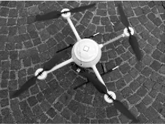
expensive. To overcome this limits we started experimenting the use of UAV in 2007 in cooperation with Zenit s.r.l. company and FBK Foundation, using Microdrones MD 200.3
This UAV was equipped with 4 rotors, carrying 200g of payload; MD-200 can fly by remote control or autonomously with a GPS navigation system, but it revealed some hardware limitations related to aircraft: first of all the equipment of Microdrones required a long preparation before it was ready to fly, then it was strongly affected by weather conditions. Moreover the MD-200 can carry only some specific kind of compact camera: the images acquired with that hardware produced very poor images that in most cases unfit the requirements for the photogrammetric processing. Even if the data resolution and details acquired with MD-200 were higher compared to those of Cessna Aircraft, they both were insufficient to perform archaeological interpretation on digital datasets, so traditional/ manual drawing in the field was still required. During Santa Marta excavation we started the experimentation of Aibot X6 Hexacopter System. This system has 6 rotors protected by a carbon fibre structure. It can fly by manual control or
2 For safety reasons we cannot fly below 150m of altitude. 3 http://www.microdrones.com
Fig. 3. Microdrones MD 200. Fig. 2. Monopod used in terrestrial image acquisition.
autonomously with the integrated GPS navigation system. The hexacopter is less affected by atmospheric conditions, making the system more versatile in archaeological fieldwork. The carbon fibre structure protects the six rotors from collision, so the aircraft can fly in low spaces and/or in low distances from the object with a very high grade of reliability. The camera mount minimizes the oscillations, allowing producing images with good depth of field and focus. The set-up system is very fast, in few minutes it is ready to fly. The UAV can carry up to 2kg payloads;4 for this reason it is possible to use a reflex or
mirrorless camera producing a very high quality images. This system has been used in 2013 and 2014 to record Santa Marta excavation: the documentation of open areas, (2000m2 in total),
has been performed in less than 2 hours, including topographic survey. The quality of images detail, the repeatability of flights with identical parameter and the high speed in performing the photogrammetric survey, make this instrument particularly suitable to the diachronic documentation of the excavation (Sarazzi et al. 2011: 1933-4).
3 Data processing
To process our image datasets we choose a low cost automated photogrammetry package, Agisoft Photoscan Pro.5 This
program is based on the approach known as ‘Structure from motion’ (SFM). The extraction and features matching in Photoscan are made with an algorithm similar to the well-known SIFT:6 it detects points in the source photos which are stable
in viewpoint and lighting variations, generating a descriptor for each point, based on its local neighbourhood. These descriptors are used later to detect correspondences across the photos. Since some layers in archaeological excavation have very homogenous texture, the algorithm can have problems to detect and match the features properly. To overcome this limit is important to use control points, measured with TS and match them a priori in the images. Furthermore, to solve intrinsic
4 http://www.aibotix.com/technical-data.html 5 For more information: http://www.agisoft.ru
6 Scale-invariant feature transform: algorithm to detect and describe
local features in images.
and extrinsic orientation parameters, Photoscan uses a greedy algorithm to find approximate camera locations, later refined using a bundle-adjustment algorithm. After the estimation of intrinsic and extrinsic parameters, it is important to optimize the alignment using control points to achieve higher accuracy and to correct possible distortion.
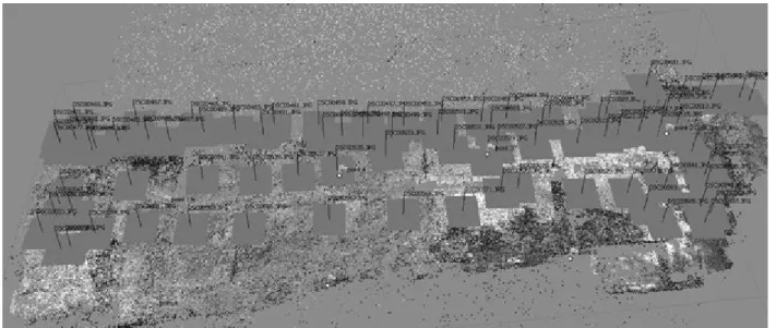
In general it is important to proceed in the workflow keeping a good level of accuracy to produce reliable documentation in which the spatial relationships among layers are properly expressed. A high level of accuracy is also needed to integrate different diachronic models. After the orientations, Photoscan can extract dense point cloud from the dataset, matching images through different algorithms, according to the requirements of the user. It is important to choose appropriate resolution to describe the context: all significant details must be recorded without creating redundant points that can increase the dimensions of the dataset, making it hard to manage. As described before, in many cases it is difficult to manage the resolution during the image acquisition by adjusting the distance between the camera and the target-object.7 One
solution is setting up the parameter of dense point cloud algorithm to use 50% or less pixel of source images during the generation process; otherwise it is possible to decimate the point cloud in external software. As for the point cloud processing operations, we use the open-source software Meshlab8 that offers several tools for processing and analyse
3D data. Point clouds can be interpolated with the filter Poisson Surface Reconstruction: this algorithm minimizes possible noise in point cloud, producing fine results. Furthermore, through setting up meshing parameters, it is possible to manage the resolution of the resulting mesh. The meshes can be rapidly cleaned from outer triangles generated by the filter (which tends to create closed mesh), through the selection and editing tools of MeshLab. This software is also a powerful tool to integrate different point-clouds to create diachronic models, a very useful aspect in archaeological research and dissemination. For
7 Ground sample distance (GSD) can be estimated by this formula: GSD = focal plane (width or height in mm) X elevation above ground (in meters) / Focal length in mm.
8 MeshLab is developed by ISTI-Cnr http://meshlab.sourceforge.net
Matteo Sordini et al: 3D Recording of Archaeological Excavation: the Case of Study of Santa Marta, Tuscany, Italy
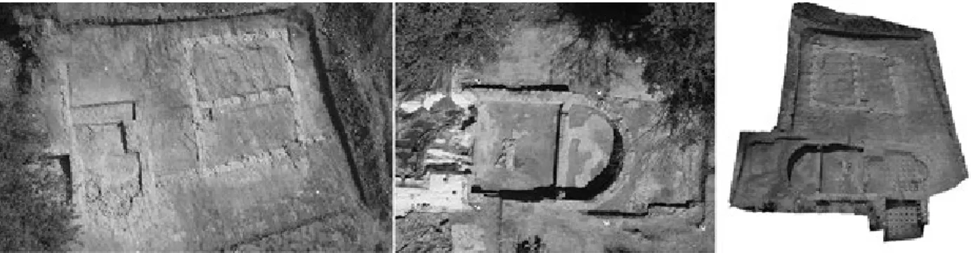
example, the rooms excavated in 2013 within the thermal area of Santa Marta, have been covered for conservation reasons. In 2014 it was possible to survey only the area investigated during the same campaign: removing the coverage was too expensive and archaeologists did not have the possibility to see the whole excavated area at the same time. To overcome this limit we proceed creating the diachronic model of all the area by integrating different datasets acquired in 2013 and 2014.The integration of dataset has been creating following this steps: • Each point clouds have been carefully cleaned removing
points from the older areas that overlap with the newer ones.
• The cleaned point clouds have been merged in a global cloud, using their intrinsic absolute coordinates.
• The global point cloud has been exported to Meshlab to produce a mesh with the algorithm described before. The last step of the workflow is the textures mapping on polygonal meshes and the creation of orthophotos of each areas: these processes are automatically performed in PhotoScan, which produces high-quality textures and orthophotos. This feature is extremely important for documentation purposes because the colour is, along with the geometry, a key-feature of archaeological stratigraphy. A proper texture resolution is chosen to represent correctly the surfaces, whereas the algorithm for colour correction is used to minimize differences of exposure among the source images. In case of mesh generated from diachronic datasets, was necessary to pay attention to the masking of the source images used for texture mapping. Afterward, the resulting textures have been edited with the open source software Gimp9 to eliminate some imperfections
and reduce some colour differences due to the integrated use of images taken in different lighting situations and site conditions. 4 Interpretation, drawings and dissemination
The documentation produced in the previous workflow is used for layers interpretation and drawing of excavation maps. Orthophotos are imported into the 2D geographic information system used to manage spatial and alphanumeric data of excavation: each stratigraphic unit has been interpreted and rendered with vector drawing. The high precision, accuracy and resolution of the images means that each layer can be drawn to
9 Gimp is open source software for 2D image editing. www.gimp.org
a higher scale and greater detail in an extremely shorter time, compared to the traditional manual drawing on site.
The possibility of drawing within the GIS system nearly simultaneously to the excavation increases the speed of the fieldwork, leaving at the same time the opportunity for archaeologists to review the context in case of doubt. 3D model of stratigraphic units are loaded on MeshLab: the software can therefore manage large datasets as individual layers, to visualize or hide them in a three-dimensional navigable space. Archaeologist can explore archaeological data with a more complete perception, compared to the top view of 2D GIS orthophoto. Furthermore the third dimension lets us to see in overlapped layers more intrinsic information, such as the thickness and the inclination of layers.
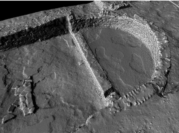
MeshLab also allows 3D measurements to change the representation of the models and to vary the lighting direction: the use of a different shader combined with different lighting conditions might improve the visualization of micro-morphological details, otherwise invisible to the naked eye. Despite the high detail of three-dimensional data set, vector drawing was considered an essential activity for the interpretation of archaeological data: indeed, through drawing, the graphic transposition of the interpretation process is performed. It is a key-phase of the interpretation, in which archaeologists can highlight some detail and exclude irrelevant features from the objective documentation produced with digital technologies.
Finally the documentation has been used for dissemination purposes. The datasets related to the archaeological excavation of Santa Marta have been uploaded in the portal Sketchfab:10
this service enables the publication of online models, allowing Internet users to view and explore the model in three dimensions. Through the functions of the embed HTML code, the model can be inserted into the web pages of the project, in order to communicate the results of the investigation to a larger public and researchers in a more effective way.
5 Conclusions
The documentation of the archaeological excavation is a process that goes beyond the graphical representation of the contexts: it is the essence of archaeologist’s interpretation process, aimed
10 https:www.sketchfab.com/ATS: sketchfab is a web portal to share interactive 3D models.
Fig. 8. Radiance scaling shade with incident light.
Matteo Sordini et al: 3D Recording of Archaeological Excavation: the Case of Study of Santa Marta, Tuscany, Italy
at understanding the history of the site. Currently, digital survey techniques and three-dimensional modelling are actually the best tools to document the archaeological evidence in term of detail, accuracy and precision. However the graphic rendering through drawing remains a key-stage within the process of archaeological interpretation, which can be improved but not avoided. Traditional surveying techniques and manual drawing, in most of contexts, can be considered totally obsolete, both for the time required to produce them and for their poor level of precision and accuracy. The case of Santa Marta highlighted the advantages of integration between topographic survey instruments and images, based on modelling to produce documentation faster and, at the same time, with a higher level of accuracy, precision and detail that can integrate acquired datasets in different years and conditions. This approach gave benefits in the organization of the activities on site, allowing archaeologist to proceed faster in excavation actions that are not anymore affected by manual drawing. UAV provided a further aid in recording large areas quickly, capturing images perfectly suitable for the photogrammetric process. Data processing in the laboratory is not affected by a heavy work time as the traditional approach or laser scanning. The most expensive step is related to computer time calculation for the alignment of images and the generation of point clouds. However, these activities do not require a constant interaction with the user, and they can work at night or simultaneously with other activities. The vector rendering of dataset through the digital drawing has allowed us representing correctly all the identified evidences, with greater detail than the traditional draw in scale 1:20. Vector drawings are made directly on orthophotos or point clouds with an up to 1mm resolution. Moreover, this activity did not
require operators with special skills in manual drawing, but just experienced archaeologists with basic GIS/CAD software skills and digital drawing rules. Besides to produce the usual 2D documentation of archaeological contexts, the three-dimensional documentation has improved the interpretation process and the context dissemination. The reversibility of the excavation through the overlap of different 3D models lets archaeologist evaluate aspects such as the thickness of the stratigraphic units without the abstraction process belonging to the traditional documentation. This information might be quantified by the measure, to produce an unlimited number of sections. The possibility of integrating different datasets means that certain situations can be represented which cannot be seen in the reality: the integration between diachronic dataset was the only solution to show both the archaeologists and the public the entire thermal area.
However this process had some limitations: whereas the geometry of the surfaces has been properly represented through the integration among different datasets, the colour still represents a problem and it is an issue that needs to be further developed. The images are characterized by different exposures and represent situations that only partially match. Through the image masking it was possible to exclude the main elements of divergence, but areas, which were not excludable, generated artefacts and unwanted elements in the resulting texture; the colour correction algorithm cannot compensate properly the variations among images very different both in exposure and colour. Another limitation is represented by the inability to manage within a GIS system the three-dimensional models and to perform 3D digital drawings: this aspect Fig. 9. Interpretation and vector drawings.
Arrighetti, A., Cavalieri, M. 2012, Il rilievo fotogrammetrico per nuvole di punti RGB della ‘sala triabsidata’ del sito archeologico di Aiano-Torraccia di Chiusi (SI). In Archeologia e Calcolatori 23: 121-33.
Alsadika, B, Remondino, F., Menna, F., Gerkea, M., Vosselmana, G. 2013. Robust extraction of image correspondences exploiting the image scene geometry and approximate camera orientation, in International Archives of the Photogrammetry. In Remote Sensing and Spatial Information Sciences XL-5/W1.
Balletti, C., Guerra, F. 2006. Il rilievo per la rappresentazione 3D: la città romana di Grumentum. In F. Guerra and A. Adami, Modelli 3D della città e del territorio: uno strumento per l’analisi urbana e territoriale, Atti del convegno nazionale Sifet ‘Le nuove frontiere della rappresentazione 3D’, Castellaneta Marina, Taranto, 14-16 giugno 2006.
Balletti, C., Guerra, F., Pillon, M., Sartorelli, L. 2007. The Grumentum’s Arena: measure, geometry and shape. In Proceeding of CIPA 2007 XXI International Symposium ‘Anticipating the future of the cultural past’, Athens, 1–6 october 2007.
Benedetti, B., Gaiani, M., Remondino, F. 2010. Modelli digitali 3D in archeologica. Il caso di Pompei. Pisa: Edizioni della Normale.
Bláha, M., Eisenbeiss, H., Sauerbier, M., Grün, A. 2013. Photogrammetric Modeling of Drapham Dzong (Buthan). IGP Bericht 312, Zurich, ETH.
Caldarelli, D., Cantini, F., Ceccaroni, F., Fatighenti, B. 2012. Nuove tecnologie per il rilievo speditivo in archeologia: il caso di San Genesio. In Archeomatica 2: 16-20.
Callieri, M., Dell’Unto, N., Dellepiane, M., Scopigno, R., Soderberg, B., Larsson, L. 2011. Documentation and Interpretation of an archaeological excavation: an experience with dense stereo matching. In VAST: The 11th International Symposium on Virtual Reality, Archaeology and Cultural Heritage: 33–40.
Campana, S., Ghisleni, M. 2014. Santa Marta: risultati preliminari della seconda campagna di scavo. In Notiziario della Soprintendenza per i Beni Archeologici della Toscana 9/2013: 494-6. Firenze, All’Insegna del Giglio.
Campana, S., Sordini, M., Remondino, F. 2008. Integration of geomatics techniques for the digital documentation of heritage areas. In R. Lasaponara and N. Masini (eds.), 1st International EARSeL Workshop, CNR, Rome, 30 september - 4 october 2008, Advances in Remote Sensing for Archaeology and Cultural Heritage Management: 309– 12. Roma, Aracne.
Campana, S., Remondino, F. 2008. Fast and Detailed Digital Documentation of Archaeological Excavations and Heritage Artifacts. In A. Posluschny, K. Lambers, I. Herzog (eds.), Layers of Perception. Proceedings of the 35th International Conference on Computer Applications
M. 2012. 3D Recording and Total Archaeology: From Landscapes to Historical Buildings. In International Journal of Heritage in the Digital Era 1, 3: 443-60. Campana, S., Remondino, F. 2014. 3D Recording and
Modelling in Archaeology and Cultural Heritage Theory and best practices. British Archaeological Reports International Series 2598, Oxford.
Cavalieri, M., Mainardi Valcarenghi, G., Novellini, A. 2009. Il rilievo fotogrammetrico: un metodo alternativo di documentazione dello scavo archeologico. Casi applicativi presso la villa romana di Aiano-Torraccia di Chiusi (SI). In Fasti Online Documents&Reserches.
Cowley, D. C., Opitz, R. S. 2013. Interpreting Archaelogical Topografy: Lasers, 3D Data, Observation, Visaulisation and Applications. Oxford, Oxbow.
D’Andrea, A., Barbarino, M. 2012. Modellare lo scavo stratigrafico: esperienze e tecniche a confronto. In Archeologia e Calcolatori 23: 229-45.
De Felice, G., Mangialardi, N. M., Sibilano, M. G., Volpe, G. 2008. Late Roman villa at Faragola (Foggia, Italy). Laser scanning for a global documentation methodology during field research. In A. Posluschny, K. Lambers, I. Herzog (eds.), Layers of Perception. Proceedings of the 35th International Conference on Computer Applications and Quantitative Methods in Archaeology, Berlin 2-6 april 2007: 98-9. Bonn, Rudolf Habelt Gmbh.
De Felice, G., Sibilano, M. G., Volpe, G. 2008. Ripensare la documentazione archeologica: nuovi percorsi per la ricerca e la comunicazione. In Archeologia e Calcolatori 19: 271-91.
Doneus, M., Neubauer, W., Studnicka, N. 2003. Digital recording of stratigraphic excavations. In K. F. Ausserer, W. Börner, M. Goryany, N. Karlhuber, N. Vöckl (eds.), Enter the Past. The E-way into the four Dimensions of Cultural Heritage. Proceedings of the 31st International Conference on Computer Applications and Quantitative Methods in Archaeology (CAA). British Archaeological Reports International Series 1227: 451-6. Oxford, Archaeopress
Doneus, M., Neubauer, W. 2005. 3D laser scanners on archaeological excavations. In Proceedings of the XX International CIPA Symposium, Torino, Italy, 26 september–1 october, 34: 226-31.
Doneus, M., Neubauer, W. 2008. Digital recording of stratigraphic Archaeological excavations using terrestrial 3D laser scanners. In ViaVIAS 02: 45-52.
Doneus, M., Verhoeven, G., Fera, M., Briese, C., Kucera, M., Neubauer, W. 2011. From Deposit To Point Cloud – A Study Of Low-cost Computer Vision Approaches For The Straightforward Documentation Of Archaeological Excavation. In Proceedings of the XXIIIrd International CIPA Symposium, Prague: 81–8.
Matteo Sordini et al: 3D Recording of Archaeological Excavation: the Case of Study of Santa Marta, Tuscany, Italy Eisenbeiss, H. 2009. UAV Photogrammetry. Unpublished PhD
thesis, Institute of Geodesy and Photogrammetry, ETH Zurich, Switzerland, Mitteilungen N.105 Available at: doi:10.3929/ethz-a-005939264
Eisenbeiss, H., Sauerbier, M. 2011. UAVS for the documentation of archaeological excavations. In International Archives of Photogrammetry, Remote Sensing and Spatial Information Sciences XXXVIII-5/V: 526–31. Newcastle upon Tyne. Fassi, F., Fregonese, L., Ackermann, S., De Troia, V. 2013.
Comparison between laser scanning and automated 3d modelling techniques to reconstruct complex and extensive cultural heritage. In International Archives of the Photogrammetry, Remote Sensing and Spatial Information Sciences XL-5/W1.
Felici, C., Campana, S., Frezza, B. 2012. La chiesa battesimale di San Pietro in Pava (San Giovanni d’Asso – SI – Italia): un incontro di dati stratigrafici, studio territoriale e attestazioni d’archivio. In Atti del XV Congresso Internazionale di Archeologia Cristiana, Toledo 8– 12 Settembre 2008: 463-80
Fiorini, A. 2008. Esperienze di fotomodellazione e stereofotorammetria archeologica. In De Felice, G., Sibilano, M. G., Volpe, G. (eds.), L’informatica e il metodo della stratigrafia, Atti del Workshop, Foggia 6-7 giugno 2008: 175-86. Bari, Edipuglia.
Fiorini, A. 2012. Tablet PC, fotogrammetria e PDF: strumenti per documentare l’archeologia. In Archeologia e Calcolatori 23: 213-27.
Forte, M., Dell’Unto, N., Issavi, J., Onsurez, L., Lercari, N. 2012. 3D archaelogy at Çatalhöyük. In International Journal of Heritage in the Digital Era 1, 3: 351–77. Gonizzi Barsanti, S., Remondino, F., Visintini, D. 2012.
Photogrammetry and Laser Scanning for archaeological site 3D modelling. Some critical issues. In V. Roberto, L. Fozzati (eds.), Proceeding of the 2nd Workshop on The New Technologies for Aquileia, B1–B10.
Gruen, A., Zhang, Z., Eisenbeiss, H. 2012. UAV photogrammetry in remote areas – 3D modeling of Drapham Dzong (Bhutan), in International Archives of the Photogrammetry, Remote Sensing and Spatial Information Sciences XXXIX-B1: 375-9. Melbourne.
La Rosa, N. 2012. La metodologia di rilievo e documentazione tridimensionale applicata al caso studio della capanna B14 nello scavo archeologico dell’età del Bronzo di Mursia, Pantelleria (TP). Unpublished MA thesis, Facoltà di Lettere e Filosofia, Università di Bologna.
Masci, M. E., De Santis, A. 2011. The EU Project CARARE and the Scuola Normale Superiore contribute: Giving Access to 2D and 3D representations of Pompeii monuments through Europeana. In Proceedings of the EVA 2011 Florence – Electronic Image & Visual Arts: 34-9. Bologna.
Musson, C., Palmer, R., Campana, S. 2005. In volo nel passato. Aerofotografia e cartografia archeologica. Firenze.
Panella, C., Gabrielli, R., Giorgi, C. 2011. Le ‘Terme di Elagabalo’ sul Palatino: sperimentazione di un metodo fotogrammetrico 3D applicato allo scavo archeologico. In Archeologia e Calcolatori 22: 243-60.
Peripimeno, M. 2009. Documentazione 3D dello scavo archeologico: prime conclusion. In P. Favia and G. Volpe (eds.), V Congresso Nazionale di Archeologia Medievale: 63–7. Firenze, All’Insegna del Giglio.
Piani, P. 2013. La strumentazione UAV nel rilievo e nella modellazione tridimensionale di un sito archeologico. In Archeomatica 1: 6-10.
Rapanà, M. 2010. Verso nuove forme di documentazione archeologica. La modellazione tridimensionale tra applicazioni e limiti di utilizzo. In Archeomatica 4: 14-8. Remondino, F., El-Hakim, S. 2006. Image-based 3D modelling:
A review. In The Photogrammetric Record, 21, 115: 269– 91.
Remondino, F., Gruen, A., Von Schwerin, J., Eisenbeiss, H., Rizzi, A., Girardi, S., Sauerbier, M., Richards, H. 2009. Multi-Sensor 3D Documentation of the Maya Site of Copan. In Proceedings of the 22nd Symposium CIPA XXII, Kyoto, Japan, 11-15 october 2009.
Remondino, F., Rizzi, A. 2010. Reality-based 3D documentation of natural and cultural heritage sites-techniques, problems and examples. In Applied Geomatics 2: 85–100.
Remondino, F. 2011a. Rilievo e modellazione 3D di siti e architetture complesse. In Disegnarecon: 90–8. Available at: doi: 10.6092/issn.1828-5961/2573
Remondino, F. 2011b. Heritage Recording and 3D Modelling with Photogrammetry and 3D Scanning. In Remote Sensing 3: 1104–38.
Remondino, F., Pizzo, S., Kersten, T., Troisi, S. 2012. Low-Cost and Open-Source Solutions for Automated Image Orientation – A Critical Overview. In M. Ioannides, D. Fritsch, J. Leissner, R. Davies, F. Remondino, R. Caffo (eds.), Progress in Cultural Heritage Preservation, 4th International Conference, EuroMed 2012, Lemessos, Cyprus, LNCS 7616: 40-54.
Rinaudo, F., Chiabrando, F., Lingua, A., Spanò, A. 2012. Archaeological site monitoring: UAV Photogrammetry can be answer. in International Archives of the Photogrammetry, Remote Sensing and Spatial Information Sciences XXXIX-B5: 583-8. Melbourne.
Russo, M, Remondino, F., Guidi, G. 2011. Principali tecniche e strumenti per il rilievo tridimensionale in ambito archeologico. In Archeologia e Calcolatori 22: 169–98. Valenti, M. (ed.) 2008. Miranduolo in Alta Val di Merse
(Chiusdino-SI). Archeologia su un sito di potere del Medioevo toscano, Firenze.
Von Schwerin, J., Richards Risetto, H., Remondino, F., Agugiaro, G., Girardi, G. 2013. The MayaArch3D project. A 3D WebGIS for analyzing ancient architecture and landscapes. In Literary and Linguistic Computing 28, 4: 736-53.