Contents lists available atScienceDirect
Environmental Research
journal homepage:www.elsevier.com/locate/envresExcess Lead-210 and Plutonium-239+240: Two suitable radiogenic soil
erosion tracers for mountain grassland sites
K. Meusburger
a,⁎, P. Porto
b, L. Mabit
c, C. La Spada
b, L. Arata
a, C. Alewell
a aEnvironmental Geosciences, University of Basel, Bernoullistrasse 30, CH-4056 Basel, SwitzerlandbDipartimento di AGRARIA, Università degli Studi Mediterranea di Reggio Calabria, Italy
cSoil and Water Management and Crop Nutrition Laboratory, FAO/IAEA Agriculture & Biotechnology Laboratory, IAEA Laboratories Seibersdorf, Seibersdorf, Austria
A R T I C L E I N F O
Keywords: 210Pb ex 239+240Pu 137Cs Fallout radionuclide Chernobyl Soil erosion Land use changeA B S T R A C T
The expected growing population and challenges associated with globalisation will increase local food and feed demands and enhance the pressure on local and regional upland soil resources. In light of these potential future developments it is necessary to define sustainable land use and tolerable soil loss rates with methods applicable and adapted to mountainous areas. Fallout-radionuclides (FRNs) are proven techniques to increase our knowledge about the status and resilience of agro-ecosystems. However, the use of the Caesium-137 (137Cs) method is complicated in the European Alps due to its heterogeneous input and the timing of the Chernobyl fallout, which occurred during a few single rain events on partly snow covered ground. Other radioisotopic techniques have been proposed to overcome these limitations. The objective of this study is to evaluate the suitability of excess Lead-210 (210Pb
ex) and Plutonium-239+240 (239+240Pu) as soil erosion tracers for three
different grassland management types at the steep slopes (slope angles between 35 and 38°) located in the Central Swiss Alps. All three FRNs identified pastures as having the highest mean ( ± standard deviation) net soil loss of−6.7 ± 1.1, −9.8 ± 6.8 and −7.0 ± 5.2 Mg ha-1yr-1for137Cs,210Pb
exand239+240Pu, respectively. A
mean soil loss of−5.7 ± 1.5, −5.2 ± 1.5 and-5.6 ± 2.1 was assessed for hayfields and the lowest rates were established for pastures with dwarf-shrubs (−5.2 ± 2.5, −4.5 ± 2.5 and −3.3 ± 2.4 Mg ha-1
yr-1for137Cs,
210Pb
exand239+240Pu, respectively). These rates, evaluated at sites with an elevated soil erosion risk exceed the
respective soil production rates. Among the three FRN methods used,239+240Pu appears as the most promising
tracer in terms of measurement uncertainty and reduced small scale variability (CV of 13%). Despite a higher level of uncertainty,210Pb
exproduced comparable results, with a wide range of erosion rates sensitive to changes
in grassland management.210Pb
excan then be as well considered as a suitable soil tracer to investigate alpine
agroecosystems.
1. Introduction
Land degradation and especially soil erosion are associated with the irretrievable loss of the basic soil resource and particularly in upland mountain areas have severe impacts on water storage and quality, en-tailing changes in water availability far beyond the mountain areas. In terms of food and feed resources, the importance of this relative un-productive marginal agricultural land decreased during the last 30 years due to the liberalization of agricultural markets that has pro-moted a global competition. In such a globalized market, farming in mountain regions is clearly disadvantaged because of higher production costs (Streifeneder and Rufjini, 2007) and, as a consequence, mountain farmland is abandoned in Europe (Lasanta et al., 2017). For example in Switzerland, despite subsidies, the number of farms decreased by 40%
between 1985 and 2008 (BFS, 2009).
These mountain grasslands might, however, regain some of their importance because of the global demand for primary phytomass for food, which should be at least more than doubled by 2050 (Koning et al., 2008). The growing world population in combination with an unrestrained soil degradation (Borrelli et al., n.d) might increase food and feed shortage in future and trigger the expansion of cultivated land towards these grass- and woodlands (Fischer et al., 2011). In light of these future developments and the expected most pronounced effects of climate change impacting mountainous areas (Beniston, 2003, 2006; Meusburger et al., 2012), it is necessary to identify sustainable land management strategies and to characterize tolerable soil loss rates with specific techniques adapted to steep, inaccessible and rough climate conditions of mountain areas. Particularly snow and avalanches, acting
http://dx.doi.org/10.1016/j.envres.2017.09.020
Received 5 May 2017; Received in revised form 18 September 2017; Accepted 18 September 2017
⁎Corresponding author.
E-mail addresses:[email protected](K. Meusburger),[email protected](L. Mabit).
0013-9351/ © 2017 The Authors. Published by Elsevier Inc. This is an open access article under the CC BY-NC-ND license (http://creativecommons.org/licenses/BY-NC-ND/4.0/).
as soil erosion agents themselves, greatly impede the use of traditional long-term soil erosion monitoring techniques such as sediment traps or erosion pins (Alewell et al., 2008; Konz et al., 2012; Meusburger et al., 2014).
Fallout radionuclides (FRN) are one of the most convenient ap-proaches to quantify soil erosion in Alpine grasslands (Alewell et al., 2014), because they account for soil loss not only by water, but also for topsoil abrasion caused by snow movement in winter when conven-tional measurements are not feasible (Meusburger et al., 2014). More-over, the FRN technique allows to complement and underpin modelled long-term soil erosion rates (Meusburger et al., 2010), although appli-cations of FRNs in context of large scale model appliappli-cations (e.g. Panagos et al., 2015) are still missing. When FRNs reach the soil surface by wet deposition, they are tightly adsorbed tofine soil particles and the subsequent lateral redistribution of adsorbed FRNs is mainly asso-ciated with soil redistribution (Zapata, 2002). The use of FRN mea-surements to quantify soil redistribution magnitude is commonly based upon a comparison of FRN inventories for individual sampling points to the local reference inventory, where soil erosion is indicated by lower FRN inventories, and sedimentation, by higher FRN levels as compared to the reference site (Ritchie and McHenry, 1990; Mabit et al., 2008). The FRN Caesium-137 (137Cs) is the most commonly used tracer for
soil erosion assessment. This radioisotope was introduced into the global environment by the thermonuclear weapons testing that took place from the mid-1950s to the early 1960s and from nuclear power plant (NPP) accidents such as Chernobyl in April-May 1986. However, due to radioactive decay the concentrations of 137Cs are decreasing particularly in the southern hemisphere, where137Cs fallout has been
much lower than in the north hemisphere (where most of the nuclear tests took place). In addition, in the Swiss alpine areas, we are con-fronted with an unusually high heterogeneity of 137Cs reference in-ventories (Alewell et al., 2014). The latter might be due to the highly uneven spatial distribution of the Chernobyl137Cs fallout and the
par-tial presence of snow cover at the end of April-May 1986 that most likely enhanced heterogeneous redistribution during the snow melt process. This heterogeneity can complicate or even compromise the use of the137Cs method as the key assumption of homogeneity of the initial fallout is not fulfilled (Haugen, 1991; Lettner et al., 1999; Golosov et al., 2008, 2013; Mabit et al., 2013). The Chernobyl fallout entails a second limitation. To convert FRN inventories into yearly soil erosion rates, the proportion of137Cs Chernobyl fallout is required to refer the erosion rates to the correct time period.
To overcome these limitations associated with the use of137Cs in
mountain areas, anthropogenic Plutonium-239+240 (239+240Pu) has been suggested by the research community as a new radioisotopic ap-proach to determine soil erosion rates in mountain areas (Alewell et al., 2014; Meusburger et al., 2016). Pu isotopes (i.e.239Pu [half-life =
24,110 years] and240Pu [half-life = 6561 years]) in European alpine areas originate solely from the past nuclear weapon tests, which re-sulted in a more homogenous input due to the longer fallout period above one decade (Alewell et al., 2014). Plutonium isotopes may also help to overcome the second limitation - the apportionment of the137Cs originating from Chernobyl fallout - by utilizing specific
239+240Pu/137Cs activity ratios. Indeed, these ratios are significantly
different for the two fallout sources with values of 0.029 ± 0.003 (Hardy et al., 1973; Hodge et al., 1996; Kelley et al., 1999) and 0.009 (Muramatsu et al., 2000) for the global and Chernobyl fallout, respec-tively.
Excess Lead-210 (210Pb
ex) could also be used to overcome these
restrictions in the Swiss alpine areas or more generally in areas which have been affected by heterogeneous137
Cs fallout. In contrast to137Cs and239+240Pu,210Pbexis a natural geogenic radioisotope (t1/2= 22.3
years), which origins from the decay of Radium-226 (226Ra).226Ra is
found in most soils and rocks and produces as its daughter short-lived gaseous Radon-222 (222Rn) having a half-life of 3.8 days. Most of this
222Rn decays to210Pb within the soil, producing supported210Pb that is
in equilibrium with the parent226Ra. However, some of the222Rn
dif-fuses from the soil into the atmosphere, where it rapidly decays to
210Pb. This additional210Pb is deposited on the ground via precipitation
and since it is not in equilibrium with the parent226Ra, it is commonly
termed unsupported or excess 210Pb (210Pbex). Because of its natural
origin,210Pb
ex fallout is essentially constant through time, although
seasonal and longer-term variations in210Pb
exconcentrations in the
atmospheric fallout (rain, snow and dry deposition) have been reported (Preiss et al., 1996). As supported210Pb can be subtracted from total Pb
in considering the226Ra to210Pb ratios, the determination of210Pb ex
has been used successfully worldwide for soil erosion assessment in the last decades (Porto and Walling, 2012; Gaspar et al., 2013; Porto et al., 2013; Mabit et al., 2014). However, its suitability as soil erosion tracer in permanent alpine grasslands has not yet been tested and validated. This study aims to fill this gap by evaluating the suitability of
210Pb
exin addition to239+240Pu for assessing soil erosion magnitude in
alpine grassland areas under three different types of management (i.e. hayfield, pasture and pasture with dwarf shrubs). Further, we hy-pothesise that 137Cs based soil redistribution estimates can be
im-proved, if information on the relative contribution of the global versus Chernobyl fallout is known. The latter will be determined by calcu-lating239+240Pu/137Cs activity ratios at reference sites. The application of the three FRNs pursues the ultimate goal to assess soil redistribution rates for the alpine grassland management type hayfield, pasture and pasture with dwarf shrubs.
Fig. 1. Location of the 9 investigated sites (hayfields – h; pastures – p; pastures with dwarf shrubs – pw) and the two reference sites (R4, R5) in the Urseren Valley (Central Swiss Alps).
2. Materials and methods 2.1. Site description and soil sampling
As a pilot alpine study site, the Urseren Valley located in Central Switzerland (Canton Uri,Fig. 1) was selected due to the availability of ancillary data e.g. on the239+240Pu isotopes (Alewell et al., 2014) and 137
Cs (Konz et al., 2012) in-situ measurements. The U-formed alpine valley extends in an E-W direction with elevations ranging between 1400 and 2500 m a.s.l. At the valley bottom (1442 m a.s.l.), average annual air temperature for the years 1950–2012 is around 3.7 ± 0.7 °C and the mean annual rainfall precipitation reaches about 1419 ± 266 mm, with approximately 30% of it falling as snow, which covers the valley from November to April (MeteoSwiss, 2013). The predominant soils are Cambisols and Podzols (anthric) based on the IUSS Working Group (2006)classification with sandy loam to loamy sand texture.
Ever since the deforestation of the valley by the Romans in the eleventh century, the vegetation cover consists of hayfields and pas-tured grasslands (63% of the area) that are, to a large extent, mixed or even dominated by dwarf shrubs. The proportion of forests, which protect the slopes from avalanches upslope of the main villages, re-presents only 1% of the surface cover. Grasslands are mainly located at slopes with median slope angles of 29° with standard deviation of 10°. These slopes are susceptible to snow avalanches and snow-gliding. These processes are besides rainfall erosivity a major trigger for soil removal (Meusburger et al., 2014). In the last decades, land use in-tensity increased on the lower slopes (where the study sites are located) and decreased in the higher, more remote areas (Meusburger and Alewell, 2008).
In summer 2014, a total of 82 soil profiles (> 40 cm or until reaching the bedrock) were collected with a soil corer of 59 mm dia-meter and 90 cm in length (Giddings Machine Company, Windsor, CO, USA). We selected nine erosional sites (at slopes near the valley bottom 1469–1616 m a.s.l) and two reference sites for our study (1476 and 1514 m a.s.l.). The erosional sites were selected to have similar topo-graphic characteristics (planar south facing slopes of 35–39° with a naturalflow barrier above) as well as soil properties (sandy loam to silt loam with a soil organic matter content of 11–13%), but with differing land use management. For a comprehensive list of site parameters, the reader is referred toKonz et al. (2009). The grassland management is subdivided into three categories: hayfields (h1-3), pastures (p1-3) and pastures with dwarf shrubs (pw1-3;Fig. 1). Dwarf shrubs are abundant in alpine grasslands and are expected to have different erosion sus-ceptibility due to differences in root morphology but also because of different interaction with rainfall erosivity and surface runoff. At each site, we collected 9 cores, of which 3 were sectioned into 2 cm depth increments and subsequently composited. The remaining 6 cores were sectioned in 2 parts 0–10 cm and 10 to > 40 cm. The previous will yield a detailed representative depth profile for each land use and the latter will allow for an assessment of the small scale variability at each site. For239+240Pu only a subset of these samples (n = 21) has been
mea-sured (Table 1).
A major challenge was the selection of suitable reference sites. In previous samplings, we considered 6 potential reference sites of which some showed a higher stability and reliability assessed with an re-sampling approach (Arata et al., 2017). For the two sites considered suitable according to this approach (R4 and R5), we collected 5 cores that were sectioned in 1 cm depth increments until the depth of 5 cm and from there on in 3 cm increments. The depth increments of thefive individual cores were mixed per corresponding depth to generate a representative composite depth profile of210Pb
exand137Cs. In order to
assess the small-scale variability, 5 additional cores were collected in close vicinity and sectioned in two parts (0–10 cm and 10 to > 40 cm). For239+240Pu we used reference data of two different profiles (each a
composite of three cores; sectioned in 3 cm increments) at R4 and R5.
The239+240Pu reference profiles we sectioned at different depth in-crements and could therefore not be used to calculate the
239+240Pu/137Cs activity ratios. For this purpose we used Pu and Cs data
of six reference sites with 3 cm increments ofAlewell et al. (2014). 2.2. Radioisotopic analysis
The determinations of210Pbexin the soil samples were carried out
using two high resolution HPGe gamma detectors at the Department of Agraria at the University Mediterranea of Reggio Calabria, Italy. The samples were sealed for 21 days prior to assay for achieving equilibrium between226Ra and its daughter222Rn. Measurements were performed
for total210Pb and226Ra (via214Pb) activities and counting times were
ca. 80,000 s providing a precision of ca. ± 10% at the 95% level of confidence. The relative uncertainty associated with the determination of 210Pb
ex derived by subtracting the two measurements was
around ± 14% at the 95% level of confidence. The detectors were ca-librated using customized standards comprising sediment of a similar grain size composition and density to the measured samples to which known amounts of certified multi-element standard (including210Pb)
had been added prior to homogenization. The standards were presented to the detectors in containers of identical geometry to those used for samples collected for the study. A correction factor of 0.78 was used to take account of exhalation loss of unsupported (also termed excess)
210Pb when calculating the226Ra supported210Pb activity. This
cor-rection factor was based on the average ratio of the measured total
210
Pb and226Ra concentrations for samples collected from the lower part of the soil profile, where fallout210Pb was assumed to be absent
(Graustein and Turekian, 1986; Wallbrink and Murray, 1996). The measurement of Plutonium isotopes (239+240Pu) activity was performed at the Northern Arizona University using a Thermo X Series II quadrupole ICP-MS. The ICP-MS instrument was equipped with a high-efficiency desolvating sample introduction system (APEX HF, ESI Scientific, Omaha, NE, USA). A detection limit of 0.1 Bq kg-1 for 239+240Pu was obtained for samples of nominal 1 g of dry-ashed material and for 239+240Pu activities above 1 Bq kg-1, the measure-ment error was 1–3%. Prior to mass spectrometry analysis, the samples were dry-ashed and spiked with 0.005 Bq of a 242Pu yield tracer (ob-tained as a licensed solution from NIST). Pu was leached with 16 M nitric acid overnight at 80 °C, and was subsequently separated from the leach solution using a Pu-selective TEVA resin (Ketterer et al., 2011). The masses of 239Pu and 240Pu present in the sample were determined by isotope dilution calculations and then converted into the summed 239+240Pu activity.(Meusburger et al., 2016). For more details garding the pros and cons of 239+240Pu analytics, the reader is re-ferred toAlewell et al. (2017).
2.3. Conversion of FRN inventories to soil erosion rates
The mass activities (Bq kg-1) of the FRNs were converted into areal activities also termed inventories (Bq m-2) with the measured mass
depth offine soil material (kg m-2sampling depth-1). Subsequently, the
inventories were derived into soil redistribution rates using the Diffusion and Migration Model (DMM) (Walling et al., 2002, 2014) and Modelling Deposition and Erosion rates with RadioNuclides (MODERN; (Arata et al., 2016a, 2016b)).
MODERN returns soil erosion and deposition rates in terms of thickness of the soil layer affected by soil redistribution processes. To estimate the thickness of soil losses/gains, MODERN aligns the total inventory of the sampling site to the depth profile of the reference site. The point of intersection along the soil profile represents the solution of the model (Arata et al., 2016a, 2016b). For210Pb
ex, a time span of 100
years is considered to convert the soil redistribution depth (cm) into soil erosion rates (Mg ha-1yr-1), because only around 4% of the original
deposition will remain longer than 100 years due to radioactive decay. It is assumed that the contribution of previous210Pbex deposit older
than one century is insignificant (Walling et al., 2002). The second assumption includes that the erosional sites and reference site received the same annual210Pbexfallout.
The DMM considers the varying inputflux over the year and the slow downward movement of the FRN into the soil profile (Walling et al., 2014). The varying inputflux is particularly advantageous in the context of137Cs, since it allows considering the relative fallout
con-tributions originating from the global and the Chernobyl fallout. For the conversion of210Pbexinventories to soil erosion rates an adaptation of
the DMM can be applied for uncultivated sites making two key as-sumptions (Walling et al., 2011). The first assumption is like for MODERN related to the time period of 100 years considered for the conversion. Secondly, it is assumed that the annual210Pb
exfallout
re-mains constant through time. Particle size selectivity during the ero-sion, transport and deposition processes may greatly alter the outcome of conversion models. But in this study, we did not implement a particle size correction factor, because erosion plot measurements at our pas-tured sites did not highlight a significant change in particle size com-position between the source soils and the collected sediments (Konz et al., 2012).
3. Results and discussion
3.1. Establishment of FRN baseline inventories and shape of the depth profiles
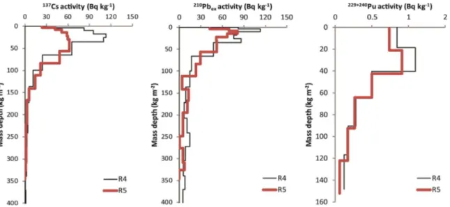
210
Pbex, 137Cs and239+240Pu activities for the reference sites
de-creased exponentially following a polynomial distribution with depth (Fig. 2). On average, 44% of the210Pb
ex, 34% of the137Cs and 25% of
the 239+240Pu activity was present in the top 3 cm and 90% of the
210Pb
ex, 96% of both the137Cs and239+240Pu activity was concentrated
in the upper 15 cm. The total inventory of the reference sites R5 is for all FRNs lower than the R4 site. For210Pbex, the deviation lies within
the observed small scale variability (expressed as coefficient of varia-tion) of 32%. For137Cs having the same CV of 32% and239+240Pu with
a lower CV of 13%, the deviation lies outside this range. Taking into account the number of reference samples and the CV, the allowable error estimated according toMabit et al. (2012)at 90% confidence level is 20% for137Cs and210Pb
exand 10% for239+240Pu. Further for R5, the
shape of the137Cs depth distribution points towards a disturbance or more likely towards heterogeneous input of137Cs, which led us to omit
the respective reference inventory of R5. Conversion to soil erosion rates has been performed using the R4 reference inventories of 8068 Bq m-2 for 210Pb
ex, 7421 Bq m-2 for 137Cs and 67 Bq m-2 for 239+240Pu. For210Pb
ex and 137Cs the DMM was fitted to the depth
profile to determine the migration rate (V), the diffusion rate (D) and
the relaxation depth (H) of V = 0.5 (VCs-137= 0.5), D = 109 (DCs-137=
38) and H = 5 (HCs-137= 5) for210Pbexand137Cs, respectively.
While the137Cs inventories and the CV correspond well with the reference inventory established at 6892 ± 2199 Bq m-2for a different
set of 6 reference sites in the Urseren Valley, the239+240Pu reference inventory is with 67 Bq m-2close to the lowest range of values (i.e. 83 ± 11 Bq m-2) reported byAlewell et al. (2014). Because of lack of
existing data, such comparison for210Pb
exwas not possible. However,
the mean annual210Pbexfalloutflux, which is well correlated with the
mean annual rainfall (Beks et al., 1998; Winkler and Rosner, 2000; Baskaran, 2011), should indicate a plausible value of around 255 Bq m -2
yr-1and confirms a higher plausibility of the elevated inventory found in R4 as compared to R5 (172 Bq m-2yr-1). For comparison purpose, in
southern Germany, the mean annual 210Pb deposition flux was
esti-mated at 180 Bq m−2 yr−1 with a mean annual precipitation of 855 mm (Winkler and Rosner, 2000) and in central Hungary (Budapest) at 81 Bq m−2 yr−1 with a mean annual precipitation of 476 mm (Central Radioanalytical Laboratory of Food and Feed Safety Directorate, 2006).
3.2. Comparison of fallout radionuclide inventories and conversion models At the investigated sites, atomic ratios of240Pu/239Pu were close to
the global fallout ratio of 0.18, indicating the absence of Chernobyl derived239+240Pu.
In contrast,137Cs originates from two different sources (i.e. the
global fallout having a peak fallout in 1963 and the Chernobyl NPP accident in April-May 1986). Therefore we need to know the relative proportions of these fallout events to the total inventory to estimate erosion rates with the137Cs method. To determine this proportion, we consulted available239+240Pu and137Cs data of six reference soil depth
profiles studied by Alewell et al. (2014). The shape of the
239+240
Pu/137Cs activity ratio depth profiles varies distinctly among the different reference sites. However, for all profiles, we observe an in-crease with soil depth indicating a higher proportion of global fallout in deeper soil layers, while in the topsoil137Cs originating from Chernobyl is predominant (Fig. 3). The predominance of the Chernobyl fallout in the topsoil is because of its more recent fallout. The peak of the bomb-derived137Cs already occurred in 1963. Consequently migration
pro-cesses may have caused depletion of the137Cs content in the upper soil layers. On average, the Chernobyl contribution amounts up to 75%. This average value will be used for the conversion of137Cs inventories.
Considering the greater proportions of137Cs in the topsoil, this might lead to an overestimation of low erosion rates and an underestimation of high erosion rates, respectively. The 75% estimate derived from the activity ratios is in good agreement with previous studies conducted in
Table 1
Soil sampling design, mean inventory values (Bq m-2) and heterogeneity of137Cs,210Pb
exand239+240Pu and inventories as coefficient of variation (CV) in% at reference sites in the
Urseren Valley (Switzerland).239+240Pu reference data fromArata et al. (2017). DW = dwarf shrubs. Numbers in brackets give replicates.
137Cs 210Pb
ex 239+240Pu
Number of sampling sites 9 (44) 9 (44) 5 (21) Hayfields h1 (2), h2 (5), h3 (6) h1 (2), h2 (5), h3 (6) h2 (3), h3 (3) Pastures p1(1), p2 (6), p3 (6) p1(1), p2 (6), p3 (6) p2 (3), p3 (3)
Pastures with DW pw1 (6), pw2 (6), pw3 (6) pw1 (6), pw2 (6), pw3 (6) pw1 (3), pw2 (3), pw3 (3) Hayfield inventory ( ± Stdev) 2371 ± 431 33 ± 5
Pasture inventory ( ± Stdev) 1985 ± 91 34 ± 18 Pasture DW inventory ( ± Stdev) 3096 ± 688 44 ± 8
Mean reference inventory 7421 8068 67
CV for reference sites 32 32 13
Number of reference cores 5 & one composite of 5 cores for R4 and R5 5 & one composite of 5 cores for R4 and R5 Composites of 3 cores for R4 and R5 Soil redistribution rates (Mg ha−1yr−1)
Conversion model DMM MODERN MODERN
Mean hayfield (min-max) −5.7 (−7.4 to −3.4) −5.2 (−11.8 to 3.4) −5.6 (−9.2 to −3.6) Mean pasture (min- max) −6.7 (−8.4 to −4.7) −9.8 (−25.2 to −2.9) −7.0 (−21.4 to −0.3) Mean pasture DW (min- max) −5.2 (−9.4 to 0.5) −4.5 (−11.5 to 0.3) −3.3 (−8.2 to −0.2)
the Swiss Alps that assumed an 80% contribution (Schaub et al., 2010; Alewell et al., 2014).
The correlations between 137Cs and 210Pbex inventories
(p < 0.0001, adjusted R2= 0.66;Fig. 4) as well as between137Cs and
239+240Pu inventories (p < 0.0001, adjusted R2= 0.62;Fig. 4) at the
sampling sites are surprisingly high considering the different fallout origins. The210Pbexinventories show a very high correlation close to a
1:1 relation with the137Cs inventories, with a slightly higher scattering
towards the high inventories (which are closer in values to the re-ference inventory). The observed FRN inventories measured at the erosional/depositional sites are a result of both the initial fallout and the subsequent soil redistribution processes. For the initial fallout, a close relation between210Pbexand239+240Pu with137Cs was not
ex-pected due to the spatially heterogeneous 137Cs Chernobyl fallout
(Fig. 3). However, we assume that the subsequent soil loss after 1986 will affect all radionuclides equally. As such, the smaller deviation between210Pb
exand239+240Pu with137Cs inventories for sites with low
inventories point to the influence of erosional processes after the main
137Cs fallout deposited in 1986 (Fig. 4).
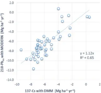
We used the conversion models MODERN and DMM to convert the FRN inventories into soil redistribution rates. For our alpine sites, the
DMM is most suitable for the137Cs data set, because this conversion
model can account for the dual137Cs input. In implementing the DMM
fitting parameters and considering a 75%137
Cs Chernobyl contribution, a regression analysis yielded comparable (p < 0.001) and only slightly lower soil redistribution rates for137Cs as compared to210Pb
ex
esti-mates (y = 1.12x; R2= 0.65; y and x soil redistribution rates assessed with210Pb
exand137Cs, respectively). The above discussed deviations
between137Cs and210Pb
exfor small inventory changes and thus small
soil redistribution rates are also visible here (Fig. 5). Mean MODERN based 210Pb
ex soil redistribution estimates are
comparable to the DMM results for210Pb
ex, but include a wider range of
soil redistribution rates (Fig. 6). The deviation between the two con-version models is significant for sites, which experienced large in-ventories changes. The latter is because MODERN does not consider the continuous input of 210Pbex over time during the soil redistribution
process. For239+240Pu, MODERN and the DMM agreed well and pro-vided similar results (p < 0.0001, adjusted R2= 0.84).
3.3. Soil erosion estimates for three land use types
A comparison among the different grassland management types displays a similar ranking with respect to soil erosion susceptibility for all FRNs used (Table 1), with highest erosion rates for pastures (−6.7 ± 1.1, −9.8 ± 6.8, −7.0 ± 5.2 Mg ha-1
yr-1for137Cs,210Pbex and 239+240Pu, respectively) followed by hayfields (−5.7 ± 4.4,
−5.2 ± 1.5, −5.6 ± 2.1 Mg ha-1yr-1for137Cs,210Pbex and239+240Pu,
respectively), and lowest rates for pastures with dwarf shrubs
Fig. 2.137Cs,210Pb
exand239+240Pu mass activity per mass-depth for the two reference depth profiles (R4 and R5).
Fig. 3.239+240Pu/137Cs activity ratios with soil depth observed for six reference sites
(MP1-6). The vertical black line indicates the typical isotopic ratio of the Chernobyl fallout and the vertical dashed line represents the specific ratio for the global fallout.
Fig. 4. Comparison of210Pb
exand239+240Pu with137Cs inventories for the erosional
(−5.2 ± 3.1, −4.5 ± 2.5, −3.3 ± 2.4 Mg ha-1
yr-1for137Cs,210Pbex and239+240Pu, respectively).
The standard deviation of erosion rates between the sites is parti-cularly high for210Pbex. The latter does not only reflect the high initial
variability of 210Pb
exestablished in the reference sites, but is likely
overlain by heterogeneous input at the erosional sites due to snow re-distribution in winter and subsequent melting in spring. Consequently,
210Pb
exderived erosion rates at our site might be biased towards higher
estimates by the snow redistribution. However, considering the overall good agreement of the inventories between the different FRNs (Fig. 4), this effect is likely of minor importance.
Independent of the FRN used, there is agreement in the mean ero-sion rate over all sites and per grassland type, however the range of values observed at individual sampling points varies considerably be-tween the applied FRNs. The deviations in the range of soil redis-tribution rates at individual sites are potentially caused by one or more of the following reasons. Firstly, the intrinsically small variability, which is further enhanced through the small scale soil redistribution patterns and trampling of grazing animals. Secondly, by the differences between the conversion models used. The DMM generally smooths the extreme values (Fig. 6). For137Cs and210Pb
ex, exactly the same sample
volumes were measured. However, for239+240Pu the different sample
volume may play a role as only a subsample of 2–3 g (< 10% of the total) was extracted for the Pu analysis. As such, special care is required to obtain a representative sub-sample. Thirdly, preferential removal of
fine soil particles – that contain varying proportions of the total in-ventory depending the tested FRN– need to be expected in areas, where water erosion is predominant (Meusburger et al., 2016). Finally, the different time frame that is captured by the different radionuclides needs to be considered. Even though210Pbexinventories are influenced
by the last 100 years of fallout deposition,210Pb
exis nevertheless in
general more sensitive to recent erosion changes (20–30 years) due to its origin and shorter half-life and as well to its higher concentration at the soil surface when compared to the other two tested FRNs (Fig. 2).
137Cs is expected to cover an intermediate time span at our sites due to
the predominant Chernobyl input, while239+240Pu is reporting about the soil redistribution status since the mid-1960s.
Regarding the three different grassland management types studied, the soil redistribution rates differ only significantly (Kruskal-Wallis test, p < 0.05) between pastures and pastures with dwarf shrubs. The dwarf shrub cover may be more effective in shielding the soil from rain splash. Moreover, the shrubs may also act as physical barriers not only for snowmelt- and surface runoff, but also for snow movement and its as-sociated sediment (Konz et al., 2012; Meusburger et al., 2014).
The selected steep sites are expected to represent grassland sites with elevated soil erosion risk. Nonetheless, comparable management at slopes between 30 and 40° can be found in one third of the catch-ment.
Different measurements across the Alps demonstrate that an intact vegetation cover prevents almost all soil loss by water erosion (Martin et al., 2010; Schindler Wildhaber et al., 2012). However, erosion stu-dies conducted at grassland plots with clear signs of degradation (re-duced vegetation cover), established even mean erosion rates as high as 20 Mg ha-1yr-1during a six-year measurement period on flysch and
molasse material in the Allgaeu Alps (Frankenberg et al., 1995). In the Bavarian Alps (Limestone Alps), Felix and Johannes (1995) found erosion rates of 4.4 Mg ha-1yr-1 (during a two-year measurement
period) on a pastured grassland test plot with a fractional vegetation cover of 66%. In another area of the Bavarian Alps,Ammer et al. (1995) measured soil erosion rates of approximately 2–9 Mg ha-1yr-1(during a
five-year measurement period) after clear cutting of the small forested catchments, which geologically belong to the flysch and limestone formations. A review of erosion measurements on marls in the French Alps reported erosion rates of 1.4–33 mm yr-1(Descroix and Mathys,
2003).
In addition, to potentially high erosion rates caused by disturbed vegetation cover, locally we can observe very high erosion rates due to snow movement (avalanches and snow gliding), which are not yet considered in the existing soil erosion risk modelling (Jomelli and Bertran, 2001; Ceaglio et al., 2012; Korup and Rixen, 2014; Meusburger et al., 2014).
Fig. 5. Comparison of137Cs (conversion model: DMM) and210Pb
ex(conversion model:
MODERN) derived soil redistribution rates considering the137Cs Chernobyl contribution.
NB: For visibility purpose, error bars that reach up to 20% have not been plotted.
Fig. 6.210Pb
exderived soil redistribution estimates
with the two different conversion models (DMM and MODERN). The numbers on the x-axis refer to the sample ID. NB: For visibility purpose, error bars that reach up to 20% have not been plotted.
4. Conclusion
Three FRNs have been used and combined to assess soil redis-tribution on three alpine grasslands. Even though239+240Pu seems the
most promising tracer in terms of measurement uncertainty and small scale variability (CV of 13%), 210Pb
exproduced nevertheless
compar-able results. 210Pb
ex exhibit a slightly wider range of erosion rates
which seemed plausible to pattern the recent changes in soil redis-tribution dynamic, as such we consider both, 239+240Pu as well as 210Pb
exsuitable soil redistribution tracers at our alpine grassland sites
(Urseren Valley, Central Switzerland).239+240Pu further allowed for an assessment of the contribution of the 137Cs Chernobyl fallout that
helped to improve the137Cs based soil redistribution estimates.
The FRN based soil redistribution estimates at the selected 9 steep (35–38°), temporally scarcely covered (due to trampling, grazing, haying and snow melt and snow abrasion) grassland sites exhibited mean soil loss above 5 Mg ha-1yr-1(ranging from maximal erosion rates
of−25.2 Mg ha-1yr-1to maximum deposition rates of +3.4 Mg ha-1yr
-1) with a considerable small scale variably. Even though the selected
sites can be considered as“hotspots” of soil erosion, it underscores the fact that compared to European arable land, too little attention has been paid to the quantification of soil erosion affecting managed mountain and alpine areas. Taking into account soil production rates in the Swiss Central Alps of 0.4–1.8 Mg ha-1
yr-1(Norton et al., 2010), it also im-plies that land use at the investigated sites is not sustainable. All FRNs indicated highest soil loss for pastures, followed by hayfield and lowest for pastures with dwarf-shrubs. However, a significant difference (i.e. p < 0.05) in soil loss was only observed between pastures and pastures with dwarf-shrubs. In scenarios of intensifying land use of alpine grasslands entailing a decline of pastures with dwarf-shrubs, an in-crease of erosion rates is likely. However, alpine grasslands have been used by humans for about 5000 years (Bätzing, 2005) and increased soil erosion might be buffered, if sustainable management and maintenance efforts are reinforced in parallel to land use intensification.
Acknowledgements
The authors would like to thank Simon Tresch, Alexandra Bürge and Axel Birkholz for support duringfield work and Dr. Michael E. Ketterer (Chemistry Department, Metropolitan State University of Denver, Colorado, USA) for the239+240
Pu measurements. The study has been performed within the International Atomic Energy Agency Coordinated Research Project D1.50.17 on “Nuclear techniques for a better under-standing of the impact of climate change on soil erosion in upland agro-ecosystems”.
References
Alewell, C., Meusburger, K., Brodbeck, M., Banninger, D., 2008. Methods to describe and predict soil erosion in mountain regions. Landsc. Urban Plan. 88, 46–53.
Alewell, C., Meusburger, K., Juretzko, G., Mabit, L., Ketterer, M., 2014. Suitability of 239+240Pu as a tracer for soil erosion in alpine grasslands. Chemosphere 103, 274–280.
Alewell, C., Pitois, A., Meusburger, K., Ketterer, M., Mabit, L., 2017.239+240Pu from “contaminant” to soil erosion tracer: where do we stand? Earth-Sci. Rev. 172, 107–123.
Ammer, U., Breitsameter, J., Zander, J., 1995. Contribution of mountain forests towards the prevention of surface runoff and soil-erosion. Forstwiss. Cent. 114, 232–249.
Arata, L., Alewell, C., Frenkel, E., A’Campo-Neuen, A., Iurian, A.-R., Ketterer, M.E., Mabit, L., Meusburger, K., 2016a. Modelling Deposition and Erosion rates with
RadioNuclides (MODERN)– Part 2: a comparison of different models to convert 239+240Pu inventories into soil redistribution rates at unploughed sites. J. Environ. Radioact. 162–163, 97–106.
Arata, L., Meusburger, K., Frenkel, E., A’Campo-Neuen, A., Iurian, A.-R., Ketterer, M.E., Mabit, L., Alewell, C., 2016b. Modelling Deposition and Erosion rates with RadioNuclides (MODERN)– Part 1: a new conversion model to derive soil redis-tribution rates from inventories of fallout radionuclides. J. Environ. Radioact. 162–163, 45–55.
Arata, L., Meusburger, K., Bürge, A., Zehringer, M., Ketterer, M.E., Mabit, L., Alewell, C., 2017. Decision support for the selection of reference sites using 137Cs as a soil erosion tracer. SOIL 3, 113–122.
Baskaran, M., 2011. Po-210 and Pb-210 as atmospheric tracers and global atmospheric Pb-210 fallout: a Review. J. Environ. Radioact. 102, 500–513.
Bätzing, W., 2005. Die Alpen: Geschichte und Zukunft einer europäischen Kulturlandschaft. - München.
Beks, J.P., Eisma, D., van der Plicht, J., 1998. A record of atmospheric Pb-210 deposition in The Netherlands. Sci. Total Environ. 222, 35–44.
Beniston, M., 2003. Climatic change in mountain regions: a review of possible impacts. Clim. Change 59, 5–31.
Beniston, M., 2006. Mountain weather and climate: a general overview and a focus on climatic change in the Alps. Hydrobiologica 562, 3–16.
BFS, 2009. Landwirtschaftliche Betriebszählungen, Landwirtschaftliche Betriebs-struk-turerhebungen, Neuchâtel.
Borrelli, P., Robinson, D.A., Fleischer, L.R., Lugato, L., Ballabio, C., Alewell, C., Meusburger, K., Modugno, S., Schütt, B., Ferro, V., Bagarello, V., Van Oost, K., Montanarella, L., Panagos, P. An Assessment of the Global Impact of 21st Century Land Use Change on Soil Erosion.
Ceaglio, E., Meusburger, K., Freppaz, M., Zanini, E., Alewell, C., 2012. Estimation of soil redistribution rates due to snow cover related processes in a mountainous area (Valle d’Aosta, NW Italy). Hydrol. Earth Syst. Sci. 16, 517–528.
Central Radioanalytical Laboratory of Food and Feed Safety Directorate, 2006. Radioanalytical Monitoring Network of Ministry of Agriculture and Rural Development, Central Radioanalytical Laboratory of Food Feed Safety Directorate -Hungarian Agricultural Authority.
Descroix, L., Mathys, N., 2003. Processes, spatio-temporal factors and measurements of current erosion in the French Southern Alps: a review. Earth Surf. Process. Landf. 28, 993–1011.
F. Zapata, 2002. Handbook for the Assessment of Soil Erosion and Sedimentation. Dordrecht.
Felix, R., Johannes, B., 1995. Research into soil erosion on test-plots in calcareous high mountains. Mitt. Der Osterreichischen Geogr. Ges. 137, 76–92.
Fischer, G., Hizsnyik, E., Prieler, S., Wiberg, D., 2011. Scarcity and Abundance of Land Resources: Competing Uses and the Shrinking Land Resource Base. FAO, Rome, Italy.
Frankenberg, P., Geier, B., Proswitz, E., Schutz, J., Seeling, S., 1995. Investigations on soil-erosion and solid matter transport in the Gunzesrieder valley Oberallgäu. Forstwiss. Cent. 114, 214–231.
Gaspar, L., Navas, A., Machin, J., Walling, D.E., 2013. Using Pb-210(ex) measurements to quantify soil redistribution along two complex toposequences in Mediterranean agroecosystems, northern Spain. Soil Tillage Res. 130, 81–90.
Golosov, V.N., Markelov, M.V., Belyaev, V.R., Zhukova, O.M., 2008. Problems in de-termining spatial inhomogeneity of Cs-137 fallout for estimating rates of erosion-accumulative processes. Russ. Meteorol. Hydrol. 33, 217–227.
Golosov, V.N., Belyaev, V.R., Markelov, M.V., 2013. Application of Chernobyl-derived 137Cs fallout for sediment redistribution studies: lessons from European Russia. Hydrol. Process. 27, 781–794.
Graustein, W.C., Turekian, K.K., 1986. Pb-210 and Cs-137 in air and soils measure the rate and vertical profile of aerosol scavening. J. Geophys. Res.-Atmos. 91, 14355–14366.
Hardy, E.P., Krey, P.W., Volchok, H.L., 1973. Global inventory and distribution of fallout Plutonium. Nature 241, 444–445.
Haugen, L.E., 1991. Small-scale variation in deposition of radiocesium from the Chernobyl fallout on cultivated grasslands in Norway. Norway 465–468.
Hodge, V., Smith, C., Whiting, J., 1996. Radiocesium and plutonium: still together in ''background'' soils after more than thirty years. Chemosphere 32, 2067–2075. IUSS, 2006. International Union of Soil Science, Tech. Rep.,World Reference Base for Soil
Resources, FAO, Rom.
Jomelli, V., Bertran, P., 2001. Wet snow avalanche deposits in the French Alps: structure and sedimentology. Geogr. Ann. Ser. A-Phys. Geogr. 83A, 15–28.
Kelley, J.M., Bond, L.A., Beasley, T.M., 1999. Global distribution of Pu isotopes and 237Np. Sci. Total Environ. 237–238, 483–500.
Ketterer, M.E., Zheng, J., Yamada, M., 2011. Applications of Transuranics as Tracers and Chronometers in the Environment. Springer-Verlag, Berlin, Berlin.
Koning, N.B.J., Van Ittersum, M.K., Becx, G.A., Van Boekel, M.A.J.S., Brandenburg, W.A., Van Den Broek, J.A., Goudriaan, J., Van Hofwegen, G., Jongeneel, R.A., Schiere, J.B., Smies, M.:, 2008. Long-term global availability of food: continued abundance or new scarcity? NJAS - Wagening. J. Life Sci. 55, 229–292.
Konz, N., Schaub, M., Prasuhn, V., Bänninger, D., Alewell, C., 2009. Cesium-137-based erosion-rate determination of a steep mountainous region. J. Plant Nutr. Soil Sci. 172, 615–622.
Konz, N., Prasuhn, V., Alewell, C., 2012. On the measurement of alpine soil erosion. CATENA 91, 63–71.
Korup, O., Rixen, C., 2014. Soil erosion and organic carbon export by wet snow ava-lanches. Cryosphere Discuss. 8, 1–19.
Lasanta, T., Arnáez, J., Pascual, N., Ruiz-Flaño, P., Errea, M.P., Lana-Renault, N., 2017. Space–time process and drivers of land abandonment in (Part 3). Eur. CATENA 149, 810–823.
Lettner, H., Bossew, P., Hubmer, A.K., 1999. Spatial variability of fallout Caesium-137 in Austrian alpine regions. J. Environ. Radioact. 47, 71–82.
Mabit, L., Benmansour, M., Walling, D.E., 2008. Comparative advantages and limitations of the fallout radionuclides137Cs,210Pb
exand7Be for assessing soil erosion and se-dimentation. J. Environ. Radioact. 99, 1799–1807.
Mabit, L., Chhem-Kieth, S., Toloza, A., Vanwalleghem, T., Bernard, C., Amate, J.I., de Molina, M.G., Gomez, J.A., 2012. Radioisotopic and physicochemical background indicators to assess soil degradation affecting olive orchards in southern Spain. Agric. Ecosyst. Environ. 159, 70–80.
Mabit, L., Meusburger, K., Fulajtar, E., Alewell, C., 2013. The usefulness of 137Cs as a tracer for soil erosion assessment: a critical reply to parsons and foster (2011).
Earth-Sci. Rev. 137, 300–307.
Mabit, L., Benmansour, M., Abril, J.M., Walling, D.E., Meusburger, K., Iurian, A.R., Bernard, C., Tarján, S., Owens, P.N., Blake, W.H., Alewell, C., 2014. Fallout210Pb
exas a soil and sediment tracer in catchment sediment budget investigations: a review. Earth-Sci. Rev. 138, 335–351.
Martin, C., Pohl, M., Alewell, C., Korner, C., Rixen, C., 2010. Interrill erosion at disturbed alpine sites: effects of plant functional diversity and vegetation cover. Basic Appl. Ecol. 11, 619–626.
MeteoSwiss, 2013. Federal Office of Meteorology and Climatology MeteoSwiss.
Meusburger, K., Alewell, C., 2008. Impacts of anthropogenic and environmental factors on the occurrence of shallow landslides in an alpine catchment (Urseren Valley, Switzerland). Nat. Hazard Earth Syst. 8, 509–520.
Meusburger, K., Konz, N., Schaub, M., Alewell, C., 2010. Soil erosion modelled with USLE and PESERA using QuickBird derived vegetation parameters in an alpine catchment. Int. J. Appl. Earth Obs. Geoinf. 12, 208–215.
Meusburger, K., Steel, A., Panagos, P., Montanarella, L., Alewell, C., 2012. Spatial and temporal variability of rainfall erosivity factor for Switzerland. Hydrol. Earth Syst. Sci. 16.
Meusburger, K., Leitinger, G., Mabit, L., Mueller, M.H., Walter, A., Alewell, C., 2014. Soil erosion by snow gliding– a first quantification attempt in a sub-alpine area, Switzerland. Hydrol. Earth Syst. Sci. 18, 3763–3775.
Meusburger, K., Mabit, L., Ketterer, M., Park, J.-H., Sandor, T., Porto, P., Alewell, C., 2016. A multi-radionuclide approach to evaluate the suitability of Pu239+240 as soil erosion tracer. Sci. Total Environ. 566, 1489–1499.
Muramatsu, Y., Rühm, W., Yoshida, S., Tagami, K., Uchida, S., Wirth, E., 2000. Concentrations of 239Pu and 240Pu and their isotopic ratios determined by ICP-MS in soils collected from the chernobyl 30-km zone. Environ. Sci. Technol. 34, 2913–2917.
Norton, K.P., von Blanckenburg, F., Kubik, P.W., 2010. Cosmogenic nuclide-derived rates of diffusive and episodic erosion in the glacially sculpted upper Rhone Valley, Swiss Alps. Earth Surf. Process. Landf. 35, 651–662.
Panagos, P., Borrelli, P., Poesen, J., Ballabio, C., Lugato, E., Meusburger, K.,
Montanarella, L., Alewell, C., 2015. The new assessment of soil loss by water erosion in Europe. Environ. Sci. Policy 54, 438–447.
Porto, P., Walling, D.E., 2012. Validating the use of Cs-137 and Pb-210(ex) measurements to estimate rates of soil loss from cultivated land in southern Italy. J. Environ.
Radioact. 106, 47–57.
Porto, P., Walling, D.E., Callegari, G., 2013. Using 137Cs and 210Pbex measurements to investigate the sediment budget of a small forested catchment in southern Italy. Hydrol. Process. 27, 795–806.
Preiss, N., Meliérè, M., Pourchet, M., 1996. A compilation of data on lead-210 con-centration in surface air andfluxes at the air-surface and water-sediment interfaces. J. Geophys. Res. 101, 28847–28862.
Ritchie, J.C., McHenry, J.R., 1990. Application of radioactive fallout Cesium-137 for measuring soil-erosion and sediment accumulation rates and patterns– a review. J. Environ. Qual. 19, 215–233.
Schaub, M., Konz, N., Meusburger, K., Alewell, C., 2010. Application of in-situ mea-surement to determine 137Cs in the Swiss Alps. J. Environ. Radioact. 101, 369–376.
Schindler Wildhaber, Y., Burri, K., Alewell, C., Bänninger, D., 2012. Evaluation of a small hybrid rainfall simulator and its application to quantify water erosion on subalpine grassland. CATENA 91, 56–62.
Streifeneder, T., Ruffini, F.V., 2007. Selected aspects of the agricultural structure change in the Alps - a comparison of harmonised agristructural indicators at municipality level within the Alpine Convention area. Ber. Landwirtsch. 85, 406–440.
Wallbrink, P.J., Murray, A.S., 1996. Determining soil loss using the inventory ratio of excess lead-210 to cesium-137. Soil Sci. Soc. Am. J. 60, 1201–1208.
Walling, D.E., Zhang, Y., He, Q., 2011. Models for deriving estimates of erosion and deposition rates from fallout radionuclide (caesium-137, excess lead-210, and ber-yllium-7) measurements and the development of user friendly software for model implementation. In: Impact of Soil Conservation Measures on Erosion Control and Soil Quality, IAEA-TECDOC-1665, Vienna.
Walling, D.E., Zhang, Y., He, Q., 2014. Conversion models and related software. In: Guidelines for Using Fallout Radionuclides to Assess Erosion and Effectiveness of Soil Conservation Strategies, IAEA-TECDOC-1741, Vienna.
Walling, D.E., He, Q., Appleby, P.G., 2002. Conversion models for use in erosion, soil-redistribution and sedimentation investigations. In: Handbook for the Assessment of Soil Erosion and Sedimentation using Environmental Radionuclides, Zapata, F. (Ed.), The Netherlands.
Winkler, R., Rosner, G., 2000. Seasonal and long-term variation of Pb-210 concentration in air, atmospheric deposition rate and total deposition velocity in south Germany. Sci. Total Environ. 263, 57–68.