UNIVERSITA’ DEGLI STUDI DI SASSARI
Dipartimento di Architettura, Design, Urbanistica
Scuola di Dottorato Architettura e Pianificazione
Spatial Planning for Tsunami Resilience:
A Case study of Kochi City, Japan
TESI DI DOTTORATO:
Sarunwit Promsaka Na Sakonnakron
RELATRICE: Prof. Paola Rizzi
DIRETTRICE: Prof. Paola Pittaluga
ACKNOWLEDGEMENT
This dissertation would not have successfully been possible without the guidance and the help of several individuals who contributed their valuable advice and assistance in assorted ways to this research. It is a pleasure to convey my gratitude to them all in my humble acknowledgment.
In the first place, I would like to express my sincere thanks and appreciation to my supervisor, Professor Paolo Rizzi for her advice and guidance from the very early stage of this research as well as for her kind encouragement throughout the period of the research. I would not have achieved this far without all the support that I have always received from her.
My grateful thanks are also extended to Professor Jan H. G. Klabbers for his valuable recommendations for constructive research methodologies and content/data analysis during the development of this research work. His support helped me to achieve a clearer structure.
I take this opportunity to express my gratitude for the support of Professor Satoshi Otsuki and Prof. I. In particular, his help provided me with valuable data and suggestions while I was doing fieldwork in Japan.
Acknowledgment is also owed to my colleagues and friends; Warangkana Korkietpitak, Yuya Aso, Mana Yamasaki, Sohei Ito, and Jutarosaga family. We have talked and exchanged our opinions, and I always received corrections from the conversations. They were also an endless source of good advice, helpful, constructive comments, and suggestions. My thanks must go to them as well.
Furthermore, I wish to thank all the faculty members of the Department of Architecture, Design and Urbanism, University of Sassari for their assistance since the start of my work in 2012, especially the head of department, Professor Paola Pittaluga.
On this occasion, I would like to thank the following organizations for the scholarship granted to me: JASSO scholarship (Japan Student Services Organization) and University of Sassari, Department of Architecture, Design and Urbanism. Their financial support has made this research possible.
Last, but by no means least, I owe a great debt to my family – my mom and sisters –for warmly supporting me through difficult times. Their understanding and kindness lifted my spirit and gave me the extra push to keep moving forward. With my family’s generous support, my dissertation came to its completion.
Spatial Planning for Tsunami Resilience:
A Case study of Kochi City, Japan
Abstract:In this research, the tsunami risk of coastal zones is taken into account. The research argues that, by adapting the resilience concept, the urban systems can be more interactive and capable to turn disaster vulnerability into a window of opportunity of creating better living environment and enhancing urban resilience against future tsunami. Addressing both theoretical debate and practical implementation of the resilience concept invovles a variety of critical issues related to the controversial definitions of vulnerability and resilience, the relevant variables for resilience, and methodologies to increase urban resilience. Hence, the research design emphasizes the above issues, aiming to enhance the effectiveness of reliable research operations.
Three research objectives are drawn up. The first objective is to describe the disaster resilience in terms of urban planning and find a way to put a concept of resilience into practice. This brings out the research hypotheses that “enhancing resilience does not always reduce existing vulnerability of cities”. Therefore, the second objective is to determine tsunami vulnerable characteristics of the coastal city based on a case study of Kochi City. Finally yet importantly, the third objective is to explore whether Kochi City is tsunami resilient or not in terms of spatial planning.
Phuket Island in Thailand and Kochi City in Japan are selected as a preliminary case study and a target case respectively. Themes of the study differ considerably between case studies. The Phuket case shows how Indian Tsunami of 2004 affected the coastal zones like Phuket, while a set of resilience benchmarks is used to identify the resilience of Phuket after the destructive disaster event. With the adopted benchmarks, a resilient city to disaster is defined by the three main characteristics that comprises of the stability of physical elements, the capability to bounce back, and the institutional capability to self-organize. Vulnerability is, on the other side of the same coin, used to defined incapability and exposure elements of systems. Therefore, increasing resilience does not always decrease vulnerability and vice versa. This means the first hypothesis is accepted. The results of the preliminary study are taken as a fundamental disciplinary in designing research methodologies for the Kochi case study.
While a case study of Phuket focuses on the aftermath of 2004 tsunami, Kochi case study rather considers more on how to improve the city’s capability of coping with the expectedly arrival tsunamis in a few decades. By following the second research objective, the study assesses disaster vulnerability of urban fabrics, covering from tangible physical conditions to intangible socio-economic structures. This assessment is based on the hypothesis that "socio-economic attributes of Kochi City are dominant factors, which categorize tsunami vulnerability this city". 357 sub-districts of 416 sub-districts in Kochi City within the city planning area are assessed by a total of 22 indicators and three integrated weighting techniques; equally distribution, AHP model, and SMARTER. Results of the assessment are produced as an urban vulnerability map. In addition, overlapping vulnerability map with tsunami potential map creates a tsunami risk map that defines fragmented districts into three group based on the vulnerability level and hazard potential level. As a result, the most vulnerable areas are not the coastal area, but they are the urbanized areas where infrastructure, buildings, and people are concentrated. In addition, elderly people and children are the major group of residents, who live in these most vulnerable areas.
When the vulnerability has been assessed, the next step is to explore the Kochi tsunami resilience in terms of spatial planning. A debate on spatial planning for tsunami resilience compises of the policy background, the policy formulation, and the platforms of policy implementation. The results show that a concept of integrating disaster risk management into spatial planning has been mentioned since the beginning of The First Comprehensive National Development Plan of 1962-1968. Nevertheless, the concern on this integration has not been fully realized until the emergence of The 5th Comprehensive National Development Plan (covering a period of 2010-2015). The national effort on implementing spatial planning for disaster resilience is translated into the Basic Act for National Resilience Contributing to Preventing and Mitigating Disasters for Developing Resilience in the Lives of the Citizenry (Act No. 95 on December 11, 2013). This act can be regarded as a new norm for building better living environment, while ensuring that human settlement is resilient to disasters. Furthermore, the national and regional policy formulation for spatial planning enables an opportunity for local planning authorities in integrated risk mitigation measures in their master plans, land use ordinances, and urban development projects. The effectiveness of those urban interventions for risk mitigation depends on how the local authorities utilize and adapt them to their local context. In case of Kochi City, the risk mitigation measures exist for preventing and alleviating fire risk, not tsunami risk. There is no incentive or penalty to limit the urban development in highly prone area to tsunami. Besides, some critical infrastructure
such as schools and hospitals are still located in the expected tsunami-affected area. Even the local spatial planning authorities have been discussed about the relocation of that infrastructure, but there is no implementation plan.
Results of the research suggest that the relocation plan of infrastructure is necessary to lessen the tsunami loss and keep urban service functioning during the recovery process of the next tsunami events. The development in tsunami prone areas shall be limited by the use of incentive and penalty in terms of the property tax, and the development right transfer. Residents in high tsunami-prone areas should be cultivated risk awareness, whihc will lead to an increase in disaster preparedness. The relocation plan and some incentives for the relocated residents should also be taken into account. Without any incentive, a majority of residents would be disagree with it. Focusing on the vulnerable inter-city at risk of tsunami, one of solutions to mitigate risk is the provision of dual spaces. The dual spaces allow residents to use as a recreation area in their daily lives, while the space can provide functions as evacuation camps, sheltering tsunami affected-households in an emergency event. The transformability of dual spaces enables to maximize the use of urban spaces in a disaster recovery process.
Table of Content
Page Abstract
Frequent Used Terminology
Chapter 1: Causes and Solutions of disaster vulnerability of coastal areas
1.1 Recording tsunamis and its recovery process 1-1
1.2 Options for framing a research problem 1-7
1.3 Research goal and objectives 1-9
1.4 A study model 1-9
1.5 Selecting case studies: Kochi City (Japan) and Phuket (Thailand) 1-10
1.6 Research Scope and Limitations 1-16
Chapter 2: Disaster Vulnerability and Resilience of the city
2.1 Urban resilience principles and systems approach 2-1
2.2 Vulnerability to disaster 2-3
2.2.1 Definitions of disaster vulnerability 2-3
2.2.2 Disaster vulnerability of a city and its components 2-6 2.2.3 Reducing vulnerability versus enhancing resilience 2-9 2.3 A resilience approach to reduce the urban system’s vulnerability to disaster 2-15 2.4 The development of urban resilience to disaster - a conceptual model 2-26 2.5 Dual spaces needed for enhancing a social learning process 2-29 2.6 Translating theoretical aspects into a research operation 2-32
Chapter 3: Preliminary research on the resilience of coastal zones (Phuket) and development of the research conceptual model
3.1 Resilience benchmarks adapted to local context 3-1
3.2 Tourism development and failures of urban management 3-2 3.3 Resilience of Phuket against the Indian Ocean Tsunami of 2004 3-4
3.3.1 Land use policies 3-5
3.3.2 Regulatory enforcement of Land use policies: the coastal zone management and land tenure problems
3-11
3.3.3 Economic stability and diversity 3-12
3.3.4 Institutional and community adaptive capacities 3-17
3.3.5 More resilient, but still vulnerable 3-19
3.3.6 Discussions 3-20
3.4 Resilience to man-made disaster: Tourism impacts on urban management 3-21 3.4.1 An ideal contemporary infrastructure planning 3-21 3.4.2 The criticism on failures of land-use management and enforcement in
coastal cities
3-26 3.4.3 Alternative urban infrastructure planning in the age of tourism 3-26
3.5 Discussions 3-28
Chapter 4: Research Methodology
4.1 A construction of research questions and research hypotheses 4-1
4.2 Research Framework Description 4-3
4.3 Research Methodology 4-5
4.3.1 A Vulnerability Assessment of Urban Fabric against Tsunami 4-5
4.3.2 A study on the interactive dual space 4-13
4.3.3 An identification of urban resilience against tsunami 4-17
4.4 Data collection 4-21
Chapter 5: Urban Vulnerability of Kochi City, Japan
Page 5.2 Urban vulnerability assessment (in terms of urban fabrics) 5-5
5.2.1 Urban density 5-5
5.2.3 Building condition 5-21
5.2.4 Demography 5-24
5.2.5 Cultural heritage 5-29
5.2.6 Land prices 5-29
5.2.7 A summary of vulnerability assessment 5-31
5.3 Natural hazard of Kochi City 5-41
5.4 Risk evaluation 5-45
Chapter 6: Results of Vulnerability Assessment
6.1 Introduction of a conceptual disaster risk oriented spatial planning / a concept of integrating disaster risk in spatial planning
6-1 6.1.1 Significant elements of spatial planning and roles in disaster risk
management
6-1 6.1.2 Good governance in the context of spatial information sharing 6-3 6.2 Disaster resilience in spatial policy and planning: a case of Kochi City, Japan 6-4
6.2.1 Policy background 6-4
6.2.2 Policy formulation and institutional structure 6-12 6.2.3 Kochi’s tsunami resilience in terms of spatial policies and regulations 6-17 6.3 A comparison of spatial planning systems in Japan, Thailand, and Italy 6-31
6.3.1 Spatial planning systems in Italy 6-31
6.3.2 Spatial planning systems in Thailand 6-32
6.3.3 Results of the comparison 6-35
6.4 Modeling spatial planning systems with a concern about disaster risks 6-39
Chapter 7: Urban analysis and synthesis: a spatial plan for tsunami resilience
7.1 The conclusion of research findings 7-2
7.2 Spatial planning for enhancing tsunami resilience 7-5 7.2.1 The needs of technical assistance for local planners and developers 7-6
7.2.2 The innovative strategic spatial policy 7-6
7.2.3 The financial incentives together with penalties for land use enforcement
7-8 7.2.4 Risk communications (techniques) along with outreach programs 7-8
7.3 Further studies 7-10
List of Tables VIII
List of Figures XI
List of Equations XII
References R-1
List of Tables
Page
Table 1-1 The shift of human cognition toward social-natural relations 1-4 Table 1-2 Population Estimates, Densities, and Land Areas 1-6 Table 1-3 Themes of the study varying on case studies 1-11 Table 2-1 SEPA Land Use Vulnerability Classification 2-7 Table 2-2 Matrix of Flood Risk - SPP Flood Risk Framework and land Use
Vulnerability Classification
2-8
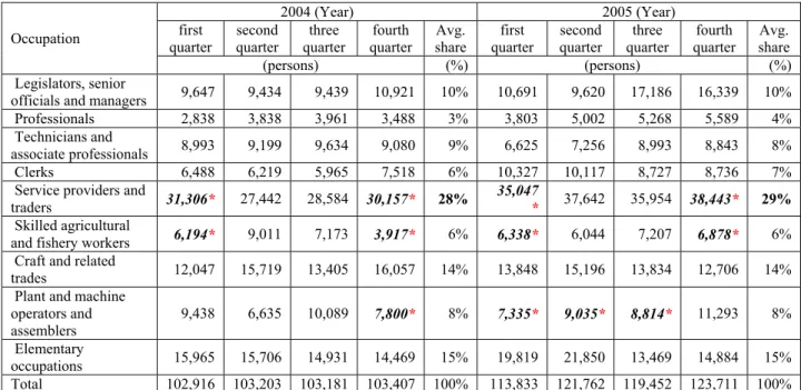
Table 2-3 Inconsistency of hazard-oriented mitigation measures 2-11 Table 2-4 Wildavsky’s principles of resilient systems 2-19 Table 2-5 Characteristics of a disaster-resilient community (a shorten table) 2-20 Table 2-6 Dimensions of resilient cities and communities 2-24 Table 3-1 Employment Number in Phuket Province by Occupations 3-16 Table 3-2 Numbers of tourist attractions and hotels categorized by administrative
districts
3-22
Table 3-3 A projection on tourism allocations between 2009- 2022 3-22 Table 3-4 A projection on local resident adjustment allocations between 2009-
2022
3-23
Table 3-5 Three components of “resilience” 3-28
Table 4-1 The relations among research objectives, questions, and hypotheses 4-2 Table 4-2 A comparison of the approaches to assessing urban vulnerability 4-8 Table 4-3 Common variables for Social Vulnerability Studies 4-8 Table 4-4 The potential indicator description applied in the vulnerability
assessment
4-12
Table 4-5 Indicators used to quantify critical facilities 4-13 Table 4-6 Matching the vulnerability level with hazard potential level 4-13
Table 4-7 Quantitative Variables of Urban Forms 4-17
Table 4-8 Considerations for resilience scheme and key performance indicators 4-20 Table 4-9 Methodologies and periods of data collection 4-21 Table 5-1 AHP Pairwise comparison values of a nine-point intensity scale 5-3 Table 5-2 Types of the building use categorized for the vulnerability assessment 5-8
Page
Table 5-3 A summary of vulnerability score in terms of potential facilities to be affected by disaster
5-18
Table 5-4 Transitions of earthquake-resistant construction regulations 5-22 Table 5-5 Districts with less active population (15-60 years old) than 50 percent 5-25
Table 5-6 Top ten districts of female majority 5-26
Table 5-7 The number of districts classified by vulnerability level 5-31 Table 5-8 The correlation between vulnerability levels (groups) and urban fabrics 5-37
Table 5-9 The Test of Homogeneity of Variances 5-38
Table 5-10 Means and standard deviations comparing three vulnerable groups 5-39 Table 5-11 One-way analysis of Variance (ANOVA) summary table comparing
vulnerability groups on urban fabric characteristics
5-40
Table 5-12 Results of risk evaluation (refer to Table 4-6) 5-45 Table 5-13 A summary of sub-districts by their tsunami-risk levels 5-45 Table 5-14 Average vulnerability scores of each tsunami risk groups 5-45 Table 6-1 Spatial oriented planning and supportive instruments of risk
management strategies
6-3
Table 6-2 A comparison of the initiative national development plan of Japan and its amendments
6-10
Table 6-3 Questions of urban planning resilience to tsunami (Key performance indicators and schemes)
6-18
Table 6-4 Descriptive statistical explanations of the result of the structured interview questions
6-19
Table 6-5 An example of evacuation orders due to heavy rain in August 2014 6-28 Table 6-6 A summary of the interview on Kochi's resilience in urban planning
against tsunami risk
6-29
Table 6-7 Significant plans related to spatial and regional development 6-32 Table 6-8 Structure of planning system in Thailand 6-34 Table 6-9 The example standard color code of land use in Thailand 6-35 Table 6-10 The comparison of spatial planning systems 6-39 Table 7-1 Research Findings in response to research questions 7-3
List of Figures
Page
Figure 1-1 A study model for building coastal resilience to tsunami 1-10
Figure 1-2 2004 Tsunami Affected Areas 1-13
Figure 1-3 Earthquakes in Japan compared to around the world 1-15 Figure 1-4 The historical record of the Nankai Earthquakes 1-16 Figure 2-1 Key spheres of the concept of vulnerability 2-5 Figure 2-2 Role of Resilience in Determining Community Response to a Hazard
Event
2-18
Figure 2-3 The key dimensions of resilience in the disaster cycle 2-25 Figure 2-4 The conceptual model of urban resilience to disaster 2-28 Figure 2-5 The integration of risk communication with spatial risk management 2-30 Figure 2-6 The spectrum of simplicity and complexity of risk modeling techniques
for risk communication
2-32
Figure 3-1 Candidate benchmarks for assessing city resilience 3-3 Figure 3-2 Legislative administration of the coastal zone in Thailand 3-5 Figure 3-3 Phuket Island and five affected areas by 2004 Tsunami 3-7 Figure 3-4 A comparison of master plans declared between in 2005 and 2011 3-9 Figure 3-5 A comparison between 2005 and 2006 master plans in Phuket 3-10 Figure 3-6 2004 Tsunami affected-villages and land tenure insecurity 3-12 Figure 3-7 Phuket GPP distribution by activities and sectors (16 sub economic
sectors)
3-15
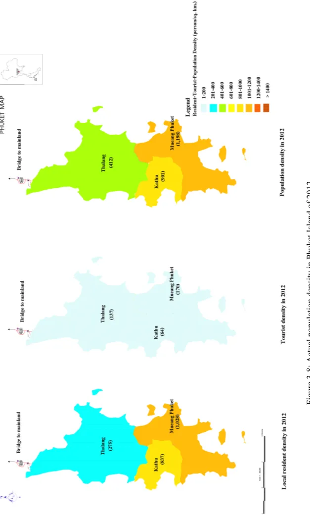
Figure 3-8 Actual population density in Phuket Island of 2012 3-24 Figure 3-9 Actual population density in Phuket Island of 2017 3-25
Figure 4-1 Research design 4-4
Figure 4-2 Measuring vulnerability as the fundamentals of specifying mitigation measures
4-6
Figure 4-3 Three Constituents of Learning process 4-14
Figure 4-4 Routes of the observation survey based on GPS records 4-21 Figure 5-1 An integration of three weighting techniques 5-4 Figure 5-2 357 sub-administrative districts (Cho) taken as a unit of analysis 5-5
Page
Figure 5-4 Vulnerability score of Residential building density 5-10
Figure 5-5 Commercial building density 5-11
Figure 5-6 Mixed-use building density 5-12
Figure 5-7 Density of heavy industry 5-13
Figure 5-8 Density of light industry 5-14
Figure 5-9 Agricultural building density 5-15
Figure 5-10 Vulnerability map in terms of building density 5-15 Figure 5-11 FAR (Floor Area Ratio) of each district 5-17 Figure 5-12 OSR (Open Space Ratio) of each district 5-17 Figure 5-13 Vulnerability map in terms of potential facilities to be affected by
disaster
5-19
Figure 5-14 Vulnerability score of most vulnerable facilities 5-19 Figure 5-15 Vulnerability score of highly vulnerable facilities 5-20 Figure 5-16 Vulnerability score of less vulnerable facilities 5-20 Figure 5-17 Vulnerability map in terms of the building condition 5-23
Figure 5-18 Vulnerability score of residents' age 5-27
Figure 5-19 Vulnerability score of the percentage of female gender 5-27 Figure 5-20 Vulnerability score of the household size 5-28 Figure 5-21 Vulnerability map in terms of the demography 5-28 Figure 5-22 Vulnerability map in terms of the cultural heritage sites 5-29 Figure 5-23 Land price distribution by Public Notice (as of 2013) 5-30 Figure 5-24 Vulnerability map in terms of the land price 5-31 Figure 5-25 Comparative vulnerability map classified by 3-percentiles of highest
score
5-32
Figure 5-26 Comparative vulnerability map classified by the standard deviation of vulnerability score
5-33
Figure 5-27 Comparative vulnerability map classified by the 3-quantiles of vulnerability score
5-34
Figure 5-28 The histogram of vulnerability score distribution 5-35 Figure 5-29 An obsoleted prediction of tsunami inundation 5-43 Figure 5-30 A comparison of two predictions on tsunami inundation 5-43
Page
Figure 5-31 Estimated Tsunami inundation 5-44
Figure 5-32 Scoring vulnerability levels in terms of tsunami inundation 5-44
Figure 5-33 Tsunami Risk Map of Kochi City 5-46
Figure 6-1 Future Population Projection 6-7
Figure 6-2 The national spatial planning system in Japan 6-12 Figure 6-3 The Structure of City Planning System in Japan 6-13 Figure 6-4 City Planning Act and Its relevant legislations 6-14 Figure 6-5 Population ratios by Area Division and City Planning Area 6-15 Figure 6 6 Respondents' opinions on the various statements related to the
integrating risk mitigation measures into spatial planning
6-20
Figure 6-6 Sings related to tsunami evacuation 6-28
Figure 6-7 Spatial planning tasks of each government hierarchy in Italy 6-32 Figure 6-8 Spatial Plan Hierarchy and Characteristic 6-34 Figure 6-9 A model for spatial planning for tsunami resilience (the integration of
risk management in spatial planning)
6-47
List of Equations
Page
Equation 2-1 Common interrelations among risk, hazard, and vulnerability 2-4 Equation 2-2 Tsunami-vulnerability and its components 2-4
Equation 3-1 Tourist density 3-22
Equation 5-1 A formulation of building density 5-9
Equation 5-2 A formula of FAR 5-16
Chapter 1
:
Tsunami vulnerability of coastal cities
Since natural disasters tend to happen more frequently and severely, urban planners, administrative organizations, and local communities should cooperate closely in monitoring, preparing, and planning the disaster management strategy. Nevertheless, the previous disaster management strategy might not be good enough to handle the degree of today’s natural disaster risks. Therefore, the study argues that, through a resilience approach, our urban systems will be more interactive and capable to turn the disaster vulnerability into opportunities of creating a better urban environment. Such an environment renders people to be more adaptive to abort tsunami shocks, maintain their livelihood, and recover from (un)foreseen perturbations caused by tsunami. The first chapter aims at explaining about the root of a term “resilience”, its importance to urban planning in the face of disaster, and the most vulnerable urban systems in the globe that should be taken into account. Those issues bring about identifying research problems, objectives, and preliminary studies, whereas those also lead to the construction of the study model.
Key words: resilience and interactivity
1.1 Statement of problems
Cities around the globe have been developing their built environment and socio-economic capabilities. Such development has changed cities from agricultural to industrial and commercial societies, leading to an increased complexity of urban dynamics. These changes could directly affect the balance between urban resource consumption and environmental conditions such as quality, carrying capacity, which in turn will lead to major transformations of living conditions and the quality of life of the inhabitants. The transformations may have positive or negative consequences, depending on how well urban planning deals with and adapts to those changes and perturbations. It is clear that negative impacts of the transformations will increase the overall vulnerability of a city.
In fact, the vulnerability in terms of environmental changes and natural disasters did not just emerge. Environmental changes and natural disasters have been a major threat to the
urban fabric of our society since rapid urbanization changed the urban landscapes and socio-economic characteristics (Mitchell, 2010). Dating back to the industrialization era in the 1970s, the capitals of major countries in the world had depended on large-scale production by light and heavy industries, which drove the urbanization. Nevertheless, the economic prosperity through the industrialization also had negative impacts with respect to the location of territories. Industrial development without proper urban management, for example, allowing developers to build factories in a residential area, could cause environmental degradation and social inequality. Inevitably, there were considerable negative side effects with respect to sufficient sanitation services for decent housing and – in general – concerning the quality of life of the inhabitants. Since the late 1970s and early 1980s many old industrial cities, especially in England, experienced the urban crisis through an accelerating decline of their traditional manufacturing industries (Bramwell & Rawding, 1996). This crisis corresponded with a growing concern about urban revitalization. As a result, since the 1980s, cities have initiated a process of urban revitalization, which aimed at restructuring their economy, emphasizing services and tourism. Nowadays, even though tourism contributes to the economic prosperity, the tourist flux and tourism cause a sharp rise in waste production as well as in the demands of urban facility and utility beyond the carrying capacity. Besides, the pressure of taking advantages of globalization stimulates huge investments in the city and creates more dense urbanized areas, especially in the disaster-prone zones.
Theoretical debates suggest that the vulnerability and disaster risk of cities are both outcomes of the previous development, and pressures shaping the progressing relationships between urbanization and urban planning. In addition, those progressing linkages become more complicated when the risk is not only caused by urban activities and environmental changes within the city, but is also caused by external environmental changes; namely natural disasters.
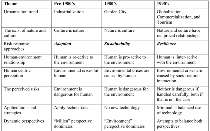
Since man-made and natural disasters tend to be more severe than in the past, human beings have been forced to seek for suitable strategies through which they are capable to protect human lives against the perceived risks, and to respond to these risks through detecting vulnerable spatiality, and social and economic factors that can cause a catastrophe. Such strategieshave been developed over time, corresponding to a growing understanding of the interactive relations between human society and nature (Table 1-1). After the experiences from a variety of destructive disasters in 1980s, we have been aware that natural disasters are not amenable to technological quick fixes alone. The attention of risk management strategies has increasingly been paid to behavior changes and disaster risk awareness that follow upon
environmental sustainability campaigns. The increase of risk awareness by world leaders has shifted the role of human society in dealing with disaster impacts from reactive to interactive.
Namely, in pre-1980’s, the scarcity of technology and human notion on disaster mitigation puts limitation on human to anticipate and respond disaster events in proactive and interactive ways. In 1980’s, the innovative development of technology rendered humans more capable of preventing and mitigating natural disasters through the provision of structural measures for disaster risk reduction. Nevertheless, the investment in structural measures was not effective in terms of costs and benefits, because humans either extensively overestimated or ignored the exact frequency and severity of natural hazards. Hence, the structural measures that were contracted during this period were costly (as they were well-constructed to prevent extremely rare hazards) or incapable to protect human settlements (as they aimed at preventing frequent natural hazards, while humans bore the impacts of residual risks through sustainability campaigns base on the nature of surrounding environment. Since 1990’s, the birth of interactive systems through a resilience approach has created the most important type of human reactions to environmental risk. This kind of systems may interact with disaster events by providing necessary risk information, physical tools, and spaces to their users and operators in order to allow them to utilize those during the emergency. Those provisions may, in turn, be feedback to the indication of how resilient the systems should be. The more resilient the systems are, the larger a perturbation they can handle.
Nowadays, disaster management strategies are more anticipatory, prepared well before the disaster happens rather than retrospective: offering lesson learned after the disaster has stricken. In addition, it has also stimulated human thinking and understanding about social-natural relationships. Correspondingly, the risk response approaches are continuously being renewed. This innovative thinking and acting leads to a series of shifts from adaption, via sustainability, to resilience, which is regarded as a core approach defining the way we enhance our capability and aptness to cope with natural disasters. The capability to self-organize and self-adapt can render cities capable of producing innovative strategies to cope with (un)anticipated perturbations. Nevertheless, it remains to be seen whether or not the resilience concept can be put into practice.
Table 1-1: The shift of human cognition toward social-natural relations
Theme Pre-1980’s 1980’s 1990’s
Urbanization trend Industrialization Garden City Globalization,
Commercialization, and Tourism
The exist of nature and culture
Culture is nature Nature is culture Nature and culture have
reciprocal relationships Risk response
approaches Adaption Sustainability Resilience
Human-environment
relationship Human is re-active to the environment Human is pro-active to the environment Human is inter-active with the environment Human centric
perception Environmental crises hit human Environmental crises are caused by human Environmental crises are caused by socio-natural interaction
The perceived risks Environment is
dangerous for human Human is dangerous for the environment Neither is dangerous if handled carefully, both if that is not the case Applied tools and
strategies Apply techno fixes No new technology Minimalist balanced use of technology Dynamic perspectives “Milieu” perspective
dominates
“Environment” perspective dominates
Attempts to balance both perspectives
Source: Adapted from Van der Leeuw & Aschan-Leygonie, 2000
Three major factors influence the interrelation between the disaster vulnerability of a city and the wider urban system: city location, its size, and type of economy (Yarnal, 2014). First, a type of disaster risks varies with the city location, differentiating between coastal and inland zone. Coastal cities can be subjected to sea level rise, tropical cyclones, and tsunami, whereas inland cities are vulnerable to floods, wildfires, and so forth. Second, the larger cities are likely to be more disaster vulnerable because they possibly consist of a larger number of exposure elements such as people and urban infrastructure. Because those cities are more densely populated and fabricated by a variety of urban infrastructures than small cities. On the other hand, as the city size is bigger, larger cities tend to have more resources - such as finances and human resources - to deal with the disasters, which can make them more capable and adaptable to mitigate those risks. Compared with big cities, small cities might be less sensitive to environmental risks – due to their smaller ‘footprint’. However, they tend to have less adaptive capacity to recover from such a disaster. Third, cities that comprises of diverse and integrated economies are less vulnerable to natural disasters. Obviously, a city that heavily relies on tourism as its sole economic activity will be sensitive to seasonal
fluctuations. Therefore, it is more vulnerable to climate change than a city that considered tourism as one of its many economic facets.
As the aforementioned debates, it can imply that nowhere else is vulnerable to environmental disasters as much as coastal cities are. The coastal zone is regarded as one of the most productive systems noun, yet highly threatened social systems in the world (Agardy, et al., 2005). This zone is combined with inland and lowland settlements, making it an urban agglomeration. Cities located along the coasts mostly become tourist attractions, where their amenities are based on a unique resource combination of land and sea. With the resource enrichment, coastal areas can provide a variety of inputs - not available to other areas - for catalyzing urban development and its economy, both qualitatively and quantitatively. This enrichment leads to an agglomeration of population, buildings, and infrastructure that stimulate urban activities and contribute to urbanization. However, this coastal urbanization is likely to be affected by destructive disasters such as tsunami. Especially, the urbanization in the Indian Ocean and the “Pacific Ring of Fire” are more vulnerable, because potential tsunami victims are larger than the other parts of the world.
International statistical data of urban settlement and population density points out that urban settlement - in large part - tends to be on or near the coasts, especially in Asia (McGranahan, et al., 2005). Regarding the definition of a coastal zone, this report typically refers either to a combination of inland, mountain, and lowland settlements or to an area extending land inward to a distance 100 kilometers from shores (McGranahan, et al., 2005). Table 1.1 shows a summary of population allocation by regions. The coastal urban system has disproportionally higher density than other settlements. The population density in coastal areas is noticeably greater than the average density of urban areas globally, because coastal cities have well-supplied resources, which lead to smart urban development and economic growth. Demographic trends suggest that coastal populations are rapidly increasing; most are through migration, increased fertility, and tourist visit (Agardy, et al., 2005). This means that demands on coastal areas for habitation, secured urban infrastructure, and even sustainable land use are increasing.
Table 1-2: Population Estimates, Densities, and Land Areas
Locations of the settlement
Population(million) Population Density(per sq. km) Total Urban Rural % of
Urban/Rural Average Urban Rural
The global Overall 6,052 2,828 3,224 46.7 46 770 25 Cultivated 4,233 1,914 2,309 45.3 119 793 70 Dryland 2,149 963 1,185 44.8 36 749 20 Forest 1,126 401 725 35.6 27 478 18 Inland Water 1,505 780 726 51.8 51 826 25 Mountain 1,154 349 805 30.3 36 636 26 Coastal zone 1,147 744 403 64.9 175 1,119 69 Case studi es Phuket Island (as of 2004) 0.261 0.114* 0.147 43.7 538 1,626* 361 Kochi Prefecture (as of June, 2014) 0.739 0.603 0.136 81.6 104 - -
Source: CIESIN et al. 2004 (Island systems are excluded.) cited in McGranahan, et al., 2005, Phuket
Provincial Statistics Office, 2012 and Kochi Prefecture’s official website, 2014 Note: *Municipal areas
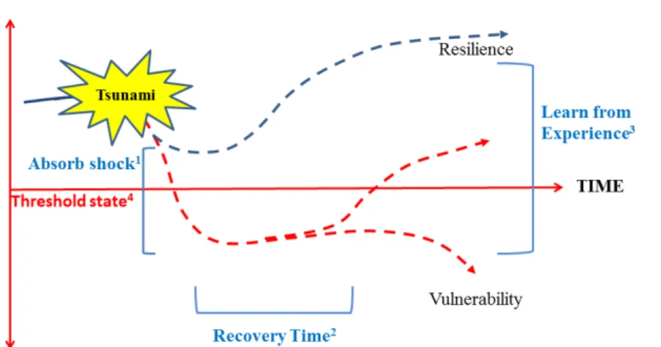
Speaking about natural risks of the coastal zone, different kinds of disaster associated with natural hazards – such as flash flood, slow-onset sea level rise, landslide, and tsunami – all directly impact the physical structure and human life. They differ with respect to the severity of the impacts and their consequences. A small disaster impact may not lead to significant changes in terms of social structure and risk management policies. A great tsunami – regarded as major disasters to the affected victims and zones –can influence the way of thinking (public risk perception and awareness) and performing (adjusting social structure and risk management policies). Therefore, tsunami risk can be considered as the potential driving force of the great sociological movement in risk management strategies that enhance urban resilience of coastal zones.
While there are many urban studies that focus mainly on financial aspects, urban poverty, governance, pollution, and city transformations as a reference point, few empirical studies on the disaster vulnerability of cities pay attention to a resilience approach of urban planning. Linkages between urbanization and disaster are weakly theorized, and disaster mitigation is rarely integrated into urban development policy (Pelling, 2003). Effective urban planning and management, optimizing urban activities and services with regard to reducing city vulnerability to disaster, do not exist. Therefore, effective coastal management requires a resilience approach that integrates sectional disaster mitigation measures into spatial planning.
Recognizing the increasing vulnerability of coastal urban system to natural disaster may lead to the provision of modern disaster risk management in terms of structural measures. However, some structural measures to mitigate disaster risks might be not cost-effective in some extent, especially for developing countries (IPCC, 2007). Moreover, vulnerable cities may be disadvantageous if there is no adequate urban intervention available to them. For example, US National Institute of Building Sciences has consolidated the number of disaster losses and found that “Approximately 90% of disaster-related expenditures currently go towards relief and reconstruction, whereas for each one dollar invested in prevention, four dollars can be saved in disaster response costs”, cited in World Economic Forum (2008). In contrast, increased investments in soft urban planning techniques, relying on the idea of urban resilience, can considerably reduce financial burdens in a disaster recovery process. This study, therefore, aims to apply resilience and urban risk management to the urban planning science. Based on the assumption that the resilience approach can alter the idea of urban planning and prepare our cities for confronting with disaster risks, this study aims at bringing forward urban planning guidance in the face of disaster.
1.2 Options for framing a research problem
To frame the research problem, the study adapted an idea of program framing from a seminar on methodology and research that was conducted by Jan HG Klabbers (Nuoro, September 5, 2014). According to this seminar, there were four main options for problem framing:
(1) Management science approach (2) Behavioral & social science approach (3) Systems science approach
(4) Political science approach
Each of these urban management approaches gives different meaning to the idea of resilience (Jan HG Klabbers). Among the four options, the study will focus on two options: 1) behavioral & social sciences approach and 2) systems science approach.
Behavioral & social sciences approach: the study focuses on the interactions between individuals and groups of decision-makers/policy-makers. This option can be used to explain effectiveness of policy implementation. Some risk management policies, even they
are well constructed to solve the real-life problems, may not be successfully implemented. There are a series of possible reasons for such failures:
(1) How well do various policies convey (disseminate) risk information to the general public, and to the particular groups of people suffering from a disaster?
(2) Do those policies sufficiently take into account local norms and circumstances? (3) Are the intended policies launched and combined with core ideas about risk
management policies?
This option is useful for explaining the symbolic meaning of norms and risk awareness that influence people and society to behave differently. The greater or lesser differences of the way people think, act, and interact can lead to both social and physical vulnerabilities to man-made and natural disasters.
As a result, the study highlights the importance of social learning and interactivity for coping with risks and disasters. The objective of elaborating the behavioral and social sciences (political) approach is to find clues for enhancing social resilience.
System sciences approach: The above problems of interactions between individuals and groups of decision-makers/policy-makers can also be identified through a system science approach. When we consider human settlements as open pluralistic systems, the needs of people and their capabilities to handle risk will vary. A specific policy/plan might not be suitable for all people. Alternative policies and risk communication techniques are needed in order to improve risk perception and raise risk awareness.
The processes of cultivating risk awareness and perception are time consuming. Alternatively, risk behavior of individuals and groups can be influenced by policy background, policy formulation, and policy implementation (the rule of law, procedures, and regulation). In this context, the norm of policy-makers, decision-makers, and regulators shall consists of a great degree of risk awareness. The transformability of existing urban spaces that can provide dual functions in regular daily life and in emergency situations is regarded as a window of opportunity for the residents, enabling or hampering them to adapt those spaces to new conditions of life and work. For example, when disasters hit, public spaces can be turned into evacuation camps (shelter-in-place), safe places for the evacuated people, assembling point (landmarks for escaping disaster), and so on. This viewpoint is based upon the assumption that disaster risk assessment and the response to it are manageable through transforming physical spaces and increasing the robustness of physical infrastructure. Such robustness leads to the increase of physical vulnerability, while the transformation of urban spaces can result in the evolving physical resilience.
1.3 Research Goals and Objectives
The fundamental goal of this research is to introduce a resilience concept and its basic premise in terms of theoretical and practical approaches to urban planning by integrating it with disaster risk management. Therefore, this study further develops and applies the resilience approach to urban disaster risk management. The ultimate goal is to propose a master plan as well as some urban intervention case studies that aim to enhance the resilience of cities, while coping with natural disasters. In order to achieve the research goals, first the current conditions of urban vulnerability to natural disasters are examined, followed by the identification of urban resilience. The gathered knowledge and understanding will be used to propose a resilient master plan. Obviously, the research objectives will include the identification of crucial factors influencing disaster vulnerability, taking into account approaches that enhance resilience. Consequently, this study comprises the following research objectives.
1. To conceptualize urban resilience in relation to urban planning and risk management and find a way to put this approach into practical application
2. To assess, through case studies, tsunami vulnerability of coastal urban systems 3. To explore/identify/investigate urban resilience to tsunami through case studies 4. To propose a conceptual master plan that can turn vulnerable cities into
tsunami-resilient cities, and illustrate how to apply that participative/interactive plan1by proposing urban intervention projects through the case studies
1.4 A study model
With regard to the shift of human cognition towards social-natural relations shown in Table 1-1, the study focuses on how constructed society and cities within the built environment can interact with environmental risks in a more resilient way. Society in this case refers to the coastal urban environment where people live, whereas tsunami is considered as an environmental risk to that inhabited area. The vulnerability of coastal urban fabrics with respect to tsunami risks manifests itself through the impact of those disasters. On the other hand, the resilience of coastal cities can be determined by how well they can cope with, adapt to, and recover from disastrous events if a tsunami occurs. The study focuses on
how to alter, change, and transform vulnerable characteristics of cities to make them more resilient to tsunami. Disaster impacts to an urbanized tsunami-prone area are being reviewed, and its way of recovery from catastrophe will be clarified.
As a result, a study model that addresses the above research questions is constructed. This model will draw up guidelines for carrying out the research. It begins with assessing the vulnerability of urban systems that are exposed to tsunami risks. Then it describes crucial characteristics of resilient urban systems. Through case studies, the study will subsequently investigate the resilience of cities that have suffered from a tsunami.
Taking into account qualitative and quantitative research methodologies, the study applies descriptive and inferential statistics through utilizing a variety of research tools such as, a questionnaire survey, an observation survey and an in-depth interview. In addition, primary and secondary data are gathered that further support research outcomes.
Keeping in mind the ultimate goal of this study, all materials will be used as input for a master plan that provides guidelines for dealing with tsunami, and aims at enhancing the resilience of the cities involved.
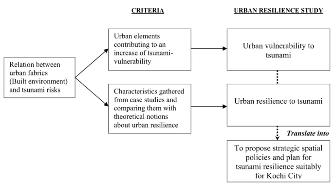
Figure 1-1: A study model for building coastal resilience to tsunami Source: By author
Relation between urban fabrics (Built environment) and tsunami risks
Urban vulnerability to tsunami
Urban resilience to tsunami
URBAN RESILIENCE STUDY
Urban elements contributing to an increase of tsunami-vulnerability
Characteristics gathered from case studies and comparing them with theoretical notions about urban resilience
To propose strategic spatial policies and plan for tsunami resilience suitably
for Kochi City
CRITERIA
1.5 A selection of case studies: Kochi City and Phuket
Regarding an urban settlement that is located in the most disaster-vulnerable area, cities in the coastal zone are considered as potential cases studies. In this zone, cities could be affected by a variety of natural disasters, such as the sea level rise, tropical cyclones, flooding, and tsunami. Among those disasters, a risk of tsunami is taken into account, because it could cause a lot of damage and destruction in its wake. Among coastal cities at risk of tsunami around the global, two Asian cities are taken as case studies: Phuket Island – Thailand, and Kochi City - Japan.
Those two cases are differentiated by the topics of study. Based on preliminary research questions, a case study in Phuket is a preliminary case study on descriptive urban resilience in a disaster recovery aspect. This can deepen understanding of resilience to tsunami as well as to re-conceptualize how a vulnerable urban system could recover from impacts of the 2004 tsunami and become more resilient. In the context of Kochi case study, the city had even experienced tsunami, and it will face the future tsunamis caused by a great Nankai earthquake every 100-year.
Hence, the case study of Kochi City is considered to be studied in a disaster preparedness aspect before the coming tsunami hits the city, and a holistic research framework of urban resilience is involved in this case study.
Table 1-3: Themes of the study varying on case studies
Theme\ Case study Phuket Island, Thailand Kochi City, Japan
Study timeframe
regarding a disaster cycle After tsunami in 2004 (the first-recorded tsunami of Thailand) Before the Tsunami (caused by great 100-year Nankai earthquake) Theme of the study Describe the disaster resilience in
terms of urban planning and find a way to put this concept into practical application
- Existing risk and the city Urban development strategy
- Indicators of being resilient that can improve urban planning
Expected results Characteristics of resilient city A proposal of a master plan, land use ordinances and the associated land use policy
Source: By author
Other reasons behind the case selection for case‐study analysis are involved with city location, city size, and the economy. The selection of case studies is further described in the following section.
1.5.1 Phuket Island, Thailand
Thailand is one of seven Asia nations having largest urban population in the Low Elevation Coastal Zone (LECZ) (McGranahan, Balk, & Anders, 2007). Amongst the major cities located in LECZ, Phuket Island - the biggest island of Thailand established as a province - is more vulnerable to disasters because more than half of the city areas, occupied by 43.7 % of 0.261 million people, are located in tsunami prone areas. The urban population density in Phuket is comparable (1,626 persons per square kilometer) to the average density of the coastal zone globally (1,119 persons per square kilometer) (Table 1-2). However, Phuket has more dense rural areas than the global average. As a result, the overall and rural population densities of Phuket are three times greater than that of the coastal zone globally. Besides the instability of the urban settlement pattern - many of urban activities heavily rely on tourism, such as hotels and restaurants. This economic activity is considered as a basic economic sector of Phuket, which has significant implications for the coastal urban system stability, and economic vitality.
An urban system is centered in urban areas where primarily sites of production and consumption activities are present (Agardy, et al., 2005; Lin, 1996). Theoretical and conceptual meaning of urban systems is mainly addressed only in terms of either ecological or economic system interacting with physical locations. In fact, the urban system has both social and biophysical dimensions, “ecosystems are understood to be biophysical systems, and the value of ecosystem services is assumed to be distinct from the value intentionally added through the application of human labor” (McGranahan, et al., 2005). It can be regarded as a closely interlinked system between ecological and socio-economic systems. The operation of the urban system of Phuket depends on tourism-based economy, the natural resources, and other infrastructure that support tourist activities. When the basic economic sector of the city collapsed, other non-basic economic activities will get affected by the changed condition; in the worst case, all of urban activities will be frozen. Bogunovich (2009) stated that “traditional urban infrastructure makes most of the city functions highly dependent on a regular supply of key resources, and a state of such high dependency is by definition a state of low resilience”.
The tsunami striking the Indian Ocean in 2004 was considered to be the worst large-scale catastrophe in the millennium. Thailand was among the most severely hit and affected countries were, and one of the most serious cases appeared in Phuket island, where thousands of local residents and domestic and international tourists were affected. With a comparison of satellite images acquired before and after 2004 tsunami, the hit of tsunami on Phuket’s coast
could be identified on December 26, 2004. Figure 1-2B is a satellite image shows a 25 km long stretch of coast north of the Phuket airport on December 31, 2004, along with an image acquired two years earlier (Figure 1-2A), and Figure 1C was simulated to highlight the affected areas. 5,395 persons from 36 countries were confirmed dead (60% of them were tourists), another 4,600 were officially classified as missing or unidentified (BBC News, 2005; Thai Red Cross, 2005; World Tourism Organization, 2005). Community, social, and personal services were unable to run their old means. A figure of employment had been immediately dropped for three months after the ghastly incident - about 20,000 positions (Kritiamphun, 2005).
Figure 1-2: 2004 Tsunami Affected Areas
Note: 1A= an image acquired on November 15, 2002, 1B= an imageacquired on December 31,2004, and 1C= Affected areas Source: NASA,GSFC,METI,Japan Space Systems, Jet Propulsion Laboratory, retrieved on March 2012 from:
http://asterweb.jpl.nasa.gov/gallery-detail.asp?name=Phuket
Even though Phuket had recovered from the disaster, another urban problem was raised as tourists were back to the region and extensively exploited the urban resources,
B
utilities, and facilities during their journeys. Regarding the coastal tourism industry, it is viewed as the world’s largest industries that are interrelated with all sectors of urban system: natural environment, built environment and socio-economic environment. The interrelated system brings an interaction among tourists, urban activities, and resources, which generates economic benefits and creating employment. On the other hand, a transformation of tourism - without regarding to existing urban capacities - heavily affects degradations of the coastal physical environment, loss of social, cultural identity, and an emergence of dependent market economies on the tourism sector. Nevertheless, a downward tourism can potentially lead to the economic recession and social tension. The influence of tourist landscapes along well-known Andaman seacoasts is still problematic. Alternatively, a holistic approach of urban system, sustainable tourism development, and a concept of tourism carrying capacity assessment are adopted in order to shed some light on future ecotourism that can minimize tourism-induced problems and maximize the positive benefits of tourism as well as ensuring both the sustainability of the tourism industry and urban development.
1.5.2 Kochi City, Japan
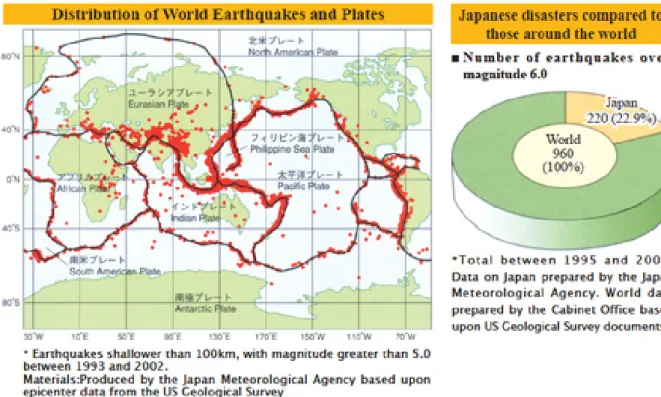
Japan is regarded as a well-known country among Asian countries in terms of national development, economic prosperity, and disaster risk management. Located in the Pacific Ring of Fire, Japan is seen as a country of earthquakes. Around 23 percent of world earthquakes of magnitude over six occur in Japan (Figure 1-3). Nevertheless, the damages resulted from inland earthquakes is not comparable with the devastative impacts of tsunami earthquakes, such as Tohoku (Sendai) earthquake and tsunami in 2011. This magnitude 8.9 offshore quake was followed by aftershocks, most of them are more than magnitude 6 (AP 3news, 2011). Hundred thousands of people were affected, and at least 1,600 people were dead, while 10,000 were missing (Branigan, 2001).
Even for a country that used to earthquakes, this quake of 2011 was one of the largest tremors to hit one of the largest tremors to hit Japan in its 140 history, and the fifth horrific quake in the world since the record-keeping began in 1980 (AP 3news, 2011). It either destroyed or badly damaged more than 20,000 buildings nationwide, Nearly 600,000 people had evacuated to either evacuation camps or their relative homes (Branigan, 2001).
In case of Kochi City, it is expected that “Nankai Earthquake”, a large earthquake with its consequent tsunami, will strike the city every 100-150 years. The latest occurrence was on December 21st, 1946 named “'Showa-Era Nankai Earthquake”. This earthquake was of magnitude 8.0, which had an epicenter at 50 kilometers off the coast of Cape Shiono in
Wakayama. It generated 4-6 meter tsunami waves that penetrated Kochi’s coastal areas and far inland, ripping 4,846 buildings off their foundations for several blocks. 679 people were killed or missing, and 1,836 were injured (Kochi International Association, 2008).
Kochi is still at high risk because there is a 40 % chance that Nankai earthquake will occur within the next three decades, according to the interview with Hiroshi Takagi, a coastal engineer, Associate Professor at the Tokyo Institute of Technology (Solomon, 2012).
Nowadays, the population of Kochi City is over a quarter of million, which means the potential tsunami-affected victims are likely to be more than the former tsunami of 1946. In addition, the new urban development is concentrated in flat land and river delta areas, which are only a few meters above main sea level. Future earthquakes with its accompanying 4-6 tsunami waves can potentially cause larger tremors than the previous ones. This implies that a great disaster impacts is left to be released.
Figure 1-3: Earthquakes in Japan compared to around the world Source: Kochi International Association (2008)
Figure 1-4: The historical record of the Nankai Earthquakes* Note: *known as the Nakai trough
Source: Data from Solomon (2012) and Kochi International Association (2008), Designed by A. Camoglio
1.6 Research Scope and Limitations
The study aims to illustrate how the theoretical plausibility of resilience can be translated into practice. A construction of the study model leads to the identification of research design and methodology. For this study, it follows principles of an iterative mixed methods study to broaden the concept of resilience from ecological disciplines into a wider interdisciplinary research on one hand, and to deepen the understanding of disaster resilience in contexts of the urban complexity on the other. Even though this interdisciplinary approach
can help the study in deliberating significant relevant issues, the study does not intend to cover all aspects and integrate those aspects into a single research. Instead of pretending to be comprehensive, the study considers only crucial matters that influence spatial planning for tsunami resilience. Therefore, some residual issues may not be addressed elaborately. For instance, the business continuity of urban commercial activities and disaster resilience in terms of transportation facilities may not be an integral part of the study. Considering the timeframe of three-year research, the study focuses more on integrating tsunami risk management in spatial policies and land use planning that can insure the lives of residents and their settlements against natural calamities (tsunami).
Common used terms
Tsunami can be described as “a series of travelling waves in the water produced by the displacement of the sea floor associated with submarine earthquakes, volcanic eruptions, or landslides” (National Oceanic and Atmospheric Administration, 2013) cited in (Dávila, Ayala, Salazar, & Ruiz-Vélez, 2014).
Chapter 2
:
Disaster Vulnerability and Resilience of the City
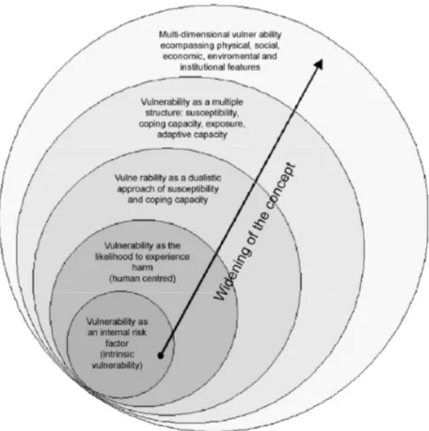
In this chapter, resilience and its relevant concepts that constituted a common ground of the research objectives and the study model at the beginning state are discussed, so as to shed the light on how the term “resilience” has developed, and how resilience and vulnerability are addressed in this research. Ideas and positions regarding the disaster resilience are being focused, and possible indicators and characteristics of disaster-resilient cities/communities are being identified in order to put theory into practice. In addition, the path traced in the latter helps in constructing a research framework, and determining a certain extent of the research development and aspects that should be focused upon. Through reviewing the literature on disaster resilience, crucial indicators influencing on the urban resilience are used to explain situations of a preliminary case study in Phuket Island, which will be discussed in details in the next chapter.
2.1 Urban resilience principles and systems approach
Residents in every city have always depended on the urban services provided by urban production and consumption. The composition of urban resources and the articulation of its inputs and outputs are all results of its system. The urban system may be defined as any network of interdependent functions within its spaces. Urban system approach can be a key organizing fundamental framework to understand cities better (Berry, 1964; Wyly, 2012). This leads to the development of various conceptual ideas in urban planning and management.
With an urban system approach, cities can be studied through various disciplines at a variety of hierarchical levels, structures, functions, and dynamics. For example, the urban system in the eyes of ecologist and socialist is an integration of a trinity comprising of (a) the natural environment, (b) the built environment and (c) the socio-economic environment, whereas planners and decision-makers see it slightly different. Upon a viewpoint of an urban planner and policy maker, one of regular methods for the urban system study is to apply a sectional analysis approach, which is used to examine the city performance based on three systems based on three sectional systems of provision: infrastructure, institutions, and
knowledge networks. Through this approach, a city is viewed as a central metaphor of a complex metabolism network, rather than its density. This concept makes an urban system not only a set of geographical parts, but also a set of interdependent and interconnected urban places. As a result, the interconnection of various parts makes urban systems analogous to a ‘set’ in mathematics, where changes in one activity will have consequences for other activities in the system. On the other hand, any significant change in one city may also cause an influence on other cities.
Berry (1964) proposed an article titled “Cities as Systems within Systems of Cities”, which emphasized on how a city works. Based on his argument, any scientific research logically comprised of two district approaches: “(a) simple inductive generalizations drawn from observable facts about the world, and (b) abstract logical constructs”. In general, the deduction drawn from the logical construct intended to test that the theoretical reliability, whilst the inductive approach was more concerned with the generation of valid scientific theory emerging from the fact and phenomena. Due to the fact that at that time an innovative computing technology was used in facilitating the large-scale studies for urbanists and making a possibility to integrate the logical constructs with the inductive generalizations, Berry was able to construct symbolic models that provided idealized representation of his scientific point related to how cities and sets of cities can be perceived as spatial systems. He invented a variety of formulas based on inductive generalizations in search of a theory. For example, a formula of the distribution of city sizes is based on a premise that “cities are the rank-size relationship for sets of cites, and the inverse-distance relationship for population densities within cities (Berry B. , 1964)”. Nevertheless, he emphasized that there is regularity among spatial variations, but the spatial variations are specific to each case. In order to analyze urban systems, inductive generalizations shall be drawn from both the facts and logical constructs, and the relevant approaches for the analysis shall be specified as the third dimension of segregation.
Based on, for example, an ecological approach, structures of an urban system can be studied through a formalized method determining the role and rule of components within overall interactive operation of dependent environmental services (Exline, Peters and Larkin; 1982 cited in Marcotullion and Boyle, 2003). These services process as systems that are imposed by organizational hierarchies; each small system is a single mechanism for the higher level of hierarchy (Lin, 1996). Urban systems, therefore, exist at several scales; those systems can be identified as either individual urban settlements or as networks of urban centers connected by flows of capital resource, commodities, human activities and consequences of activities (McGranahan, et al., Urban Systems, 2005; Armstong & McGee, 1985). The system
sciences approach changes the ways in which planners address urban environmental problems from a design based solution to an aspect of urban management. This aspect of urban management aims to bring functions of each part of the entire system under control and to enhance adaptive capacity of the entire system for coping with any risky perturbations.
The efforts of urban planning and management have been trying to manage and zone our cities in such a way that allows a reasonable degree of density, public transport, and facility provision in order to put cities to the areas that optimize economic value, preserve social contexts, and lower environmental cost. However, there is some question as to whether the design, plans, and technological solutions added to the urban systems will enable sustainable settlements and turn them to be more resilient to natural disasters or not. This considerable curiosity has been paid to a coastal zone where it is perceived as a downstream recipient of negative impacts of land use that is unprotected or marginally protected (Agardy, et al., 2005). With the devastating impact of tsunami, the coastal cities face with a deeper and prolonged crisis than inland cities do. Therefore, building resilience of the urban communities to this disaster is a foremost priority.
2.2 Vulnerability to disaster
The definition of “vulnerability” is the state of susceptibility to damage from both exposure to stresses associated with environmental and social change, and the inability to adapt or cope with unforeseen circumstances or emergency events (W. Neil, 2006). For instance, the financial vulnerability to flood risk can be determined by the inability of flood-affected households to maintain the old means of their livelihood or even smooth their consumption through saving and borrowings, despite income fluctuation seems to be a crucial root of the problem that is threatening vulnerable household, especially for low-income households.
2.2.1 Definitions of Disaster Vulnerability
With the attempt to define the meaning of vulnerability and risk, a variety of possible definitions is revealed. The variety of this terminology varies considerably in terms of objectives and its main focus of assessment (for example, Bohle, 2001; Cannon T. , 2008; Cannon, Twigg, & Rowell, 2005; IPCC, 2007; Pelling, 2003). Viewing vulnerabity through multifaceted nature brings about different definitions and approaches leading to an unclear situation what vulnerability stands for (Bogardi & Birkmann, 2004). Moreover, it becomes paradoxical when there are attempts to to measure vulnerabilty, even though it cannot be defined precisely. As a result, there is no consensus on how to measure the complex vulnerability. Nevertheless, methods usually involve the relation between vulnerability and its