Università degli Studi “Roma Tre”
Facoltà di Scienze Matematiche, Fisiche e Naturali
Dipartimento di Scienze Geologiche
Dottorato di Ricerca
Geologia dell’Ambiente e Geodinamica
XXII CICLO
DEFINITION OF SEISMOGENIC SOURCES IN POORLY
KNOWN TECTONICALLY ACTIVE REGIONS OF THE
ITALIAN PENINSULA
Stefano Gori
Relatore: Coordinatore:
Prof. Francesco Dramis Prof. Domenico Cosentino
Co-Tutori: Revisori:
Dr. Fabrizio Galadini Dr. Maria Eliana Poli
….Al mio Papà, alla mia Mamma e
alla mia Emanuela….
Table of contents
1. Introduction p. 1
2. Geological setting and seismotectonic framework of the p. 4 central Apennines and of the Calabrian Arc
2.1 The central Apennines p. 4
2.2 The Calabrian Arc p. 12
3. Methods p. 19
4. Case studies in the central Apennines p. 21
4.1 The Mt. Morrone fault system p. 21
4.1.1 Field data p. 23
4.2 The Maiella-Porrara normal fault system p. 40
4.2.1 Field data p. 41
4.3 The Paganica fault and surface co-seismic ruptures p. 54 caused by the April 6, 2009 earthquake
4.3.1 Field data p. 56
5. Case study in the Calabrian Arc p. 73
5.1 Evidence of active inverse faulting in the north-eastern p. 73 sector of the Calabrian Arc
5.1.1 Field data p. 74
6. Discussion p. 81
6.1 Mt. Morrone fault system p. 81
6.1.1 Kinematics of the fault system p. 81
6.1.2 Slip rate p. 81
6.1.3 Expected magnitude p. 85
6.2 The Maiella-Porrara normal fault system p. 86 6.2.1 Kinematic history of the fault system p. 86
6.2.2 Slip rate p. 89
6.2.3 Maximum expected magnitude p. 89 6.3 The Paganica Fault and the April 6, 2009 “L’Aquila” p. 90 seismic event
6.4 Evidence of active inverse faulting in the north-eastern p. 91 sector of the Calabrian Arc
7. Conclusions p. 92
1 1. INTRODUCTION
The Italian seismic history is studded with small-to-large magnitude earthquakes occurred through the centuries. Information about strong seismic events of the past have been derived from historical sources the study of which brought to light the occurrence of earthquakes during a chronological interval spanning about the past two millennia and that, in many cases, have been responsible for widespread destruction of towns and villages and of thousands of casualties.
Many efforts have been therefore produced in the past decades in order to understand the seismotectonic characteristics of the Italian territory and to identify tectonic structures 1) responsible for these historical destructive seismic events and 2) potentially responsible for future earthquakes. Geological studies aiming at the identification of these faults began during the 1970s, when some “pioneering” studies (Bosi, 1975) identified “probable active faults” along several slopes of the Apennines.
A strong improvement to the knowledge about the active tectonics in Italy has been obtained during the 1980s with the “Progetto Finalizzato Geodinamica”, sponsored by the National Research Council, which resulted in the Neotectonic Map of Italy (CNR-PFG, 1987). The map collected all the most updated information gathered by a large number of researchers involved in the project on tectonic structures that, by means of geological and geomorphological observations, were identified and classified on the basis of their geometry, kinematics and chronology of activity. At the end of the 1990s, a huge amount of work has been made by researchers involved in the CNR-GNDT (National Group for the Defence against Earthquakes) to gather information (by the available literature an by means of “brand new” studies of GNDT and PALEOSIS projects) on the surficial evidence of primary active faults in peninsular Italy, aiming at the production of an inventory of the traces at the surface of the active faults (Galadini et al., 2001).
After many decades of studies, however, there are still some critical elements in terms of the definition of the seismotectonic characteristics of Italy, summarised below, that still need accurate analyses and efforts to be “enlightened” and more deeply understood in order to be properly managed in a seismic hazard assessment perspective:
• the presence of tectonic structures, active during the Late Pleistocene-Holocene and considered as potentially responsible for destructive earthquakes, to which
2 no historical seismic events can be attributed. These faults, commonly defined as “silent seismogenic source”, represent probable seismic gaps;
• the presence of faults the current activity of which is presently debated;
• the occurrence of strong earthquakes in historical times the causative faults of which have not been conclusively defined to date.
On this basis, the present study aims at providing new information, gathered by means of new geological, geomorphological and structural investigations, useful for improving the knowledge about the seismotectonic features of some sectors of the central Apennines (described below at points 1, 2 and 3) and of the north-eastern part of the Calabrian region (point 4)
In detail, we will analyse:
1) the fault system affecting the SW slopes of Mt. Morrone, a mountain ridge that delimits the eastern border of the Sulmona depression, in the Abruzzi Apennines. This fault system shows evidence of Late Pleistocene-Holocene activity (e.g. Vittori et al. 1995; Miccadei et al. 1998; Galadini and Galli 2000) and is considered as potentially responsible for M=6.5-7 earthquake. According to the available literature (e.g. Galadini and Galli; 2001; Ceccaroni et al., 2009), the last episode of activation of this fault system probably occurred about 1,800 years ago (i.e. during the 2nd century A.D.). Therefore, the time that has elapsed since the last activation is in the order of the mean recurrence interval for central Apennine faults, i.e. 1500-2500 years. For this reason, the Mt. Morrone fault is considered as one of the most problematic Italian tectonic cases in seismic hazard perspective;
2) the sector of the central Apennines comprised between the Maiella Massif, Mt. Morrone and Mt. Porrara. This area has been the epicentre of the 1706 earthquake (Maw=6.6; Working Group CPTI 2004), one of the strongest historical seismic event of the central Italy, the source of which is still under debate. Within this light, studies have made in the past to define the geometry and kinematics of the probable active faults in this sector. Two opposite hypotheses assume: i) the present activity of the normal fault located along the western Maiella Massif slopes, i.e. the Caramanico fault of Ghisetti and Vezzani (2002), and ii) the out-of sequence thrusting at the frontal zone of the Maiella
3 anticline, proposed by Sauro and Zampieri (2004) and Lavecchia and de Nardis (2009). These two hypotheses indicate that the location and geometry of the active faults in this area represents the main seismotectonic open problem of this sector;
3) the epicentral area of the April 6, 2009 earthquake (Mw 6.3) that severely struck the city of L’Aquila and surrounding sectors, aiming at i) analysing the Quaternary activity of the Paganica fault, presently considered as the causative fault of the seismic event (e.g. Emergeo Working Group, 2009), and ii) describing the evidence of coseismic surface rupturing along this tectonic structure. This fault was already analysed by different researchers in the past (Bagnaia et al., 1992; Boncio et al., 2004) but its Late Quaternary activity was never investigated in detail. Moreover, other strong earthquakes have affected the L’Aquila region in historical times (i.e., 1461, Mw 6.4; 1762, Mw 5.9; 1916, Mw 5.2; 1958, Mw 5.2; Working Group CPTI, 2004; see also Rossi et al., 2005) but the source of these events has never been conclusively defined;
4) the NE portion of the Calabrian Arc, in the area of Rossano Calabro, where the main known tectonic feature of the area is the Rossano Fault, a normal fault bounding to N and NE the Sila Massif. This fault shows evidence of activity through the whole Quaternary (Corbi et al. 2009; Galli et al., 2006). For this reason, some authors propose the Rossano fault as the possible causative tectonic structure of the earthquake that struck this region in 1836 (Maw 6.2; Working Group CPTI, 2004). Nevertheless, thorough geological data supporting this hypothesis have not been provided to date and, therefore, the causative fault of this seismic event is still a matter of debate.
Following sections providing basic information on the recent evolution of the central Apennines and of the Calabrian Arc, and on the seismotectonic framework of the areas under investigation, the collected data will be exposed and discussed. The information gathered provides the basis for the defining, or reappraising, of the kinematics, slip rates and maximum expected magnitude of the analysed – newly found, in some cases – fault systems. These represent the fundamental ingredients for the estimation of the seismogenic behaviour and seismic potential of the investigated areas.
4 2. GEOLOGICAL SETTING AND SEISMOTECTONIC FRAMEWORK OF THE CENTRAL APENNINES AND OF THE CALABRIAN ARC
2.1 The central Apennines
The genesis of the Apennine chain is the result of the complex geodynamic process that has characterised – and that is still characterising – the central Mediterranean area, related to the interaction between the African and European plates and the Adria and Sardinia-Corsica microplates.
The chain consists of thrust and fold systems, that migrated towards E and NE in response to the westward subduction of the Adriatic lithosphere and its progressive eastward flexural retreat (e.g. Parotto and Praturlon 1975; Mostardini and Merlini 1988; Bally et al. 1989; Patacca et al. 1990; Cipollari et al. 1999; Meletti et al. 2000; Patacca and Scandone 2001; Patacca et al. 2008).
In the central Apennines, the compressive deformation determined the juxtaposition of terrains pertaining to different Meso-Cenozoic paleo-geographic domains:
• carbonate platform, known as “Piattaforma Laziale-Abruzzese” which, although strongly dissected by tectonic deformations, maintains a structural continuity (Parotto and Praturlon, 1975) through the chain;
• carbonate basins, located at the margins of the platform, as the “Bacino Umbro-Marchigiano-Sabino” and the “Bacino Molisano”. The sequences are outcropping in the northern and southern sectors of the central Apennines (Parotto and Praturlon, 1975);
• transitional zones, located between the platform and the basins (Parotto and Praturlon, 1975).
During the formation of the central Apennines, these paleo-geographic units have been displaced by the compressive fronts that, since Oligocene, progressively migrated from the Tyrrhenian sectors towards the Adriatic, as witnessed by the formation of different silici-clastic wedges, related to foredeep domains, and of piggy-back basins progressively younger towards E-NE (Patacca et al., 1990; Cipollari and Cosentino, 1997; Cosentino et al., 2003).
During Pliocene, while the compressive fronts were located in the Adriatic sectors, the western part of the chain was affected by an extensional tectonics linked to the opening of the Tyrrhenian basin. This led to a drastic change of the tectonic setting
5 inherited by the compressive deformation, with the formation of normal fault systems. This new process led to a crustal thinning – and the reduction of the lithosphere width – that favoured the arising of magmas during the Pleistocene and the formation of the volcanic districts located along the Tyrrhenian margin of the chain (Cosentino and Parotto, 1986; Cavinato et al., 1994).
The extensional deformation has partitioned along newly formed, NW-SE trending, normal faults and along the extensional structures that re-used fault planes inherited from the compressive phase (Cavinato et al. 1994; Bosi et al., 1994).
Contemporaneously to the extension, the central Apennines experienced uplift (up to 1,500 m) (e.g. Galadini et al., 2003a; Ascione et al., 2008), with an increase of the uplift rate probably occurred since the end of the Early Pleistocene and the beginning of the Middle Pleistocene (D’Agostino et al., 2001). A strict relationship between the extensional tectonic phase and the uplift of the chain has been proposed by different authors (Doglioni, 1995; D’Agostino et al. 2001; Galadini et al. 2003).
The activity of these NW-SE trending normal fault systems determined the formation of wide intermontane tectonic depressions, such as the Fucino, Norcia, Rieti, L’Aquila, Sulmona and Leonessa basins, and of minor depressions located in the mountainous areas (e.g. the Campo Imperatore, Campo Felice and Castelluccio plains, and the Salto and Turano valleys). These depressions, bounded by normal fault systems along the eastern sides, hosted sequences of continental deposits of Plio-Quaternary age, hundreds of metres-thick. The onset of the continental deposition occurred during Pliocene, thus indicating the emersion of the central Apennine chain since this period (e.g. Bosi et al., 2003, Galadini et al., 2003a).
Many works have analysed the continental sedimentary sequences contained within the intermontane depressions and some attempts of correlation between the stratigraphic units among the different basins, based on the detection of comparable morpho-litho-stratigraphic features, have been produced (e.g. Bosi and Messina, 1992; Cavinato et al., 1994; Bosi et al. 2003; Centamore et al. 2003; Fubelli, 2004). An example of this is shown in Figures 2.1.1 and 2.1.2.
6 Fig. 2.1.1 – Stratigraphic scheme (and morphological features related to the main erosional landscapes and top depositional surfaces) of the Latium-Abruzzi Apennines (from Bosi et al., 2003).
Fig. 2.1.2 – Morpho-stratigraphic schemes of some basins in the Latium-Abruzzi Apennines (from Bosi et al., 2003).
7 By means of the analysis of the continental stratigraphic sequences, information about the evolution of the extensional deformation in the central Apennines has been obtained. Indeed, according to the available literature (e.g. Lavecchia et al.,1994; Martini and Sagri, 1994; Bartole, 1995; Calamita et al., 1999; Galadini and Messina, 2004), comparably to the compressive front, the extensional deformation underwent a progressive migration towards E and NE. This process, related to the flexural retreat of the westward subducting Adriatic lithosphere (Patacca et al.,1990;Ghisetti and Vezzani,1999; Cavinato and De Celles, 1999), determined the formation of extensional tectonic structures that are progressively younger heading eastwards. Galadini and Messina (2004) and Fubelli et al. (2009) issued that the migration of the extensional deformation resulted in the onset, during the Early Pleistocene, of the activity of the normal fault systems located in the easternmost sectors of the central Apennines (e.g. the Campo Imperatore, Mt. Morrone, Mt. Vettore fault systems). On the contrary, since the Early or the Middle Pleistocene, the activity of the extensional tectonic structures responsible for the formation of the westernmost depressions (e.g. the Salto valley, Turano valley, Liri basin and Leonessa basin fault systems) ceased (or strongly reduced), as they are sealed by deposits and landforms related to this period. As for the fault located in the intermediate sectors of the chain, instead, the mentioned authors defined a persistence of the activity since the Late Pliocene, through the whole Quaternary.
Many of these central Apennine normal and normal oblique faults show evidence of Late Pleistocene-Holocene activity (Fig. 2.1.3) and are therefore considered as active (Barchi et al., 2000; Galadini and Galli, 2000; Galadini et al., 2001; Valensise and Pantosti, 2001).
The active tectonic structures are made of segments, usually dipping towards W and SW, the length of which ranges between 5 and 20 km. Shorter segments are organised in fault systems made of 3-to-5 minor faults showing en-echelon relationship (often dextral step over). The length of the fault systems do not exceed 33 km (i.e. the cases of the Fucino basin and the Gran Sasso Range).
8 These active faults and fault systems are considered as the surficial expression of seismogenic sources potentially responsible for earthquakes characterised by moderate-to-large magnitudes (generally 5.8<M<7.0) (e.g. Galadini and Galli, 2000; Valensise and Pantosti, 2001). The fault-seismogenic sources dip is generally ranging between 40° and 60°, based on structural surficial and sub-surficial data (e.g. Barchi et al., 2000 and references therein).
The available literature generally agrees in considering the active faults of the central Apennines as arranged into NW-SE trending sets, paralleling the axis of the chain. The number of the sets is still debated. Indeed, Boncio et al. (2004) indicate that three active fault sets can be detected. On the contrary, no more than two sets are identified in other regional inventories of central Apennine active faults (e.g. Galadini and Galli, 2000; Valensise and Pantosti, 2001). The open question derives
Fig. 2.1.3 – Seismotectonic framework of the central Apennines (modified after Galadini and Galli, 2000). MVF - Mt. Vettore fault; NF – Norcia fault system; LMF - Laga Mts. fault; UAVF - Upper Aterno Valley fault system; ACIF – Assergi-Campo Imperatore fault system; CF-OPF - Campo Felice-Ovindoli-Pezza fault system; MA-SVS - Middle Aterno-Subequana Valley fault system; MMF - Mt. Morrone fault; FF - Fucino fault; ACF - Aremogna-Cinquemiglia fault; USVS - Upper Sangro Valley fault system.
9 from different interpretation of the recent fault activity in the western Apennine domain.
Many studies, both geological and paleoseismological (e.g. Galadini and Galli, 2000; Galli et al., 2008 and references therein) permitted the definition of those features, as the slip rate, the mean recurrence interval, the time elapsed since the last activation, that are fundamental for the parameterisation of the activity of these tectonic structures (Fig. 2.1.4).
As for the slip rate, the data indicate that the mean slip rate for the central Apennines fault is comprised between 0.4 and 1.2 mm/yr (with a preference for intermediate values, i.e. 0.6-0.8 mm/yr). The mean recurrence interval per fault is in the order of 1500-2500 years.
On this basis, the active faults to which no historical earthquake can be attributed – taking into consideration that the available historical seismic catalogues are complete at least in the past 800 years for high-magnitude earthquakes (Stucchi et al. 2004) – are commonly defined “silent seismogenic source” and the probability of activation of these silent faults in a future time span of social interest is considered as high.
Episodes of activation of some of the described active normal tectonic structures determined the occurrence of destructive seismic events in historical times (Working group CPTI; 2004; 2008), the main of which are: the 1461 (Maw=6.4), 1703 (January, 14) (Maw=6.81), 1703 (February 2) (Maw=6.65), 1706 (Maw=6.6),
Fig. 2.1.4 – Summary of available data on the geometric characteristics and kinematic parameters related to the active faults of central Apennines (from Galadini and Galli, 2000).
10 1762 (Maw 5.9), 1915, (Maw=6.99), 1933 (Maw=5.7) and 1950 (Maw=5.7) earthquakes as well as the shocks of the 1349 and 1456 seismic sequences (Maw=6.6 and 7.0, respectively).
A comparison between the central Apennines active faults array and the damage distribution, plus paleoseismologically-inferred data, has allowed the attribution of the 1703 (January 14), 1703 (February 2) and 1915 earthquakes to activation events of the Norcia, Upper Aterno and Fucino fault systems, respectively (Galadini and Galli, 1999; Moro et al., 2002; Galli et al., 2005).
As for the origin of the 1461 seismic event (Fig. 2.1.5), Galadini and Galli (2000) hypothesised a possible activation of one segment of the Assergi-Campo Imperatore fault system (namely the Assergi fault) during this earthquake, although the authors issued that sufficient data are lacking to concretely relate this earthquake to this tectonic structure.
On the other hand, Boncio et al. (2004) hypothesised an activation of a seismogenic fault named as “Aquilano s.l.” (the geometry of this fault, as described by these authors, is depicted in the next sections), during the 1461 and the 1762 seismic events.
As far as the causative fault of the 1706 and 1933 earthquake is concerned, Meletti et al. (1988) proposed the so-called “Ortona-Roccamonfina line” (see Fig. 2.1.3) as the possible source for the former seismic event. This structural feature is a NNE-SSW to N-S trending major regional shear zone that separates the Abruzzi Apennine fronts from the Molise domain thrust sheets (Patacca et al., 1991). By considering recent
Fig. 2.1.5 – Damage distribution related to the 1461 earthquake (http://emidius.mi.ingv .it/DBMI08/).
11 studies on the active thrusting at the frontal zone of the Maiella anticline (Sauro and Zampieri, 2004; Lavecchia and de Nardis, 2009), and on the activity of the Caramanico fault, an about 40 km long normal fault that bounds the Maiella massif to the west (Ghisetti and Vezzani, 2002), the activation of one of these tectonic structures during the 1706 earthquake cannot be excluded.
However, there is no clear and commonly accepted geological evidence that directly supports these hypotheses. Moreover, a discussion on the activity of the Caramanico fault is reported in the present work.
Although the seismic energy associated with the 1706 and 1933 earthquakes was different, the damage distribution of the two seismic events was comparable, in terms of damaged localities (Figs. 2.1.6 and 2.1.7, respectively).
For this reason, Galadini and Galli (2007) hypothesised that the same seismogenic process might have been responsible for both of these seismic events, and they related these to either (i) the activation of a single, but still undefined, seismogenic fault segment during both of these events or (ii) the activation of two different segments (with similar trends) of the same, again undefined, fault system. The magnitude of an earthquake expected from activation of the Mt. Morrone fault system (one of the objects of the present study) would be in the order of 6.5 to 7.0, and would be comparable, therefore, to that of the 1706 seismic event (Galadini
Fig. 2.1.6 – Damage distribution related to the 1706 earthquake
(http://emidius.mi.ingv.it/DBMI08/)
Fig. 2.1.7 – Damage distribution related to the 1933 earthquake
12 and Galli 2000). However, the geometry of the Mt. Morrone fault does not appear to be consistent with the damage distribution of the 1706 earthquake, since the highest intensities are mainly located in the footwall and centred in a sector located ESE of the fault (Galadini and Galli 2007).
A new hypothesis about the origin of the 1706 is proposed in this thesis.
Lastly, archaeoseismological data have indicated an episode of widespread destruction in the Sulmona area during the 2nd century AD, which was related to the occurrence of a large-magnitude earthquake of local origin (Galadini and Galli 2001). This seismic event may be related to the activation (probably the last episode of activation) of the Mt. Morrone normal fault system (Ceccaroni et al., 2009). 2.2 The Calabrian arc
The Calabrian arc is an accretionary wedge lying above a narrow and steeply dipping slab subducting towards NW, beneath the back-arc Tyrrhenian basin.
Tomographic images show a northwestward dipping slab beneath the Calabrian subduction zone, which is interrupted by a 150 km-wide window beneath the southern Apennines (Selvaggi and Chiarabba, 1995; Lucente et al., 1999; Piromallo and Morelli, 2003; Wortel and Spakman, 2000; Montuori et al., 2007). This window opened after tearing occurring within a composite subduction system, formed by the Apulian continental lithosphere and the Ionian oceanic slab (Chiarabba et al., 2008; Rosenbaum et al., 2008).
The related Wadati-Benioff zone is “enlightened” by the hypocenters of hundreds of deep earthquakes recorded in the last decades (Faccenna et al., 2001; Vannucci et al., 2004; Chiarabba et al., 2008).
The “backbone” of the Arc is mainly represented by metamorphic and igneous rocks pertaining to the European geological domain the present position of which is due to the SE-drifting of this block of European continental crust that occurred since the Miocene (e.g. Gueguen et al., 1998; Rosenbaum and Lister, 2004; 2008; Cifelli et al., 2007). Since the Early Miocene, overthrusting of the Palaeozoic basement nappes on the Meso-Cenozoic basinal sequences occurred through compressive structures progressively younger eastwards. This led to the formation of the Calabria orogenic belt (e.g. Parotto and Praturlon, 2004) (Fig. 2.2.1).
13 An extensive and detailed analysis of the tectonic evolution of the Calabrian Arc has been recently performed by Minelli (2009) who investigated the present structural setting of the Arc and of the accretionary prism, by means of geological interpretation of industrial seismic reflection profiles, corroborated by stratigraphic data.
In detail, the author distinguished four major structural domains with different evolution stages and styles: the Crotone-Spartivento foreland basin, the inner accretionary prism, the outer accretionary prism, and the foreland basin. Moreover, Minelli (2009) proposed a model of space-time evolution of Calabrian accretionary prism in the last 15 Ma. This model defines the growth of the prism, comprising the forward propagation stages, with frontal accretion, and out-of-sequence internal thrusting (of Pliocene age, at least).
During the eastward migration of the compressive domain – progressively affecting the Ionian sectors – extensional tectonics occurred in the inner portions of the Calabrian arc since the Miocene-Pliocene (e.g. Ghisetti, 1979; 1980; Tortorici et al., 1995; Monaco et al., 1996; Mattei et al., 2002; Cifelli et al. 2007). The extensional
Fig. 2.2.1 – Geological map of the Calabria-Peloritani Arc (modified from Bigi et al., 1990; Cifelli et al., 2004; Minelli et al. 2009)
14 tectonics determined the formation of normal-to-transtensive fault systems, mainly parallel to the axis of the Arc, which displaced the structural edifice inherited by the compressive deformation (Monaco et al., 1996). The activity of these extensional structures determined the formation of N-S and NE-SW elongated tectonic depressions, e.g. the Crati and Mesima valleys and the Sant’Eufemia, Gioia Tauro (the area investigated in the present study) and Messina Strait basins, that hosted marine and continental sedimentary sequences (e.g. Ghisetti, 1981).
Most of these N-S and NE-SW faults often interrupt against other faults trending almost perpendicularly to the Calabrian Arc, i.e. E-W and WNW-ESE, as the Rossano, Catanzaro Strait and Nicotera-Coccorino fault systems (e.g. Moretti, 2000; Galadini et al., 2001; Galli and Bosi, 2003; Galli et al., 2006; Tortorici et al. 2003; Guarnieri, 2006; Rosenbaum et al., 2008). These structural features have probably had a complex kinematic and structural history, as they may have played – and still play – the role of 1) tear faults, accommodating differential motions of the Calabrian accretionary prism, and/or 2) transfer faults, kinematically linking different, en-echelon arranged N-S and NE-SW normal fault systems.
In particular, two regional structural features, trending perpendicular to the axis of the Calabrian belt and known as “San Gineto Line” and “Taormina Line” (Fig. 2.2.2) permitted the juxtaposition of the metamorphic terrains of the Calabrian Units, pertaining to the European domain (e.g. Amodio Morelli et al., 1976) with the carbonate sequences of the southern Apennines and of the Maghrebian Chain, respectively (e.g. Van Dijk et al., 2000; Tansi et al., 2007).
15 Of course, the structural setting and evolution at the junction between the Calabrian Arc and the southern Apennines, to the north, and the Maghrebides, to the south-west, is still a matter of debate. Indeed, as for the northern boundary (which is partly investigated by the present study), the southern Apennines and the Calabrian arc fold-and-thrust belts are presently not linked (Minelli, 2009).
Comparably to the Apennine chain, the Calabrian Arc experienced rapid uplift during the Quaternary, contemporaneous to the extensional deformation. Different mechanisms have been invoked as having caused the uplift. Some authors argued that it is due to an isostatic rebound related to either slab break-off (Westaway, 1993; Wortel and Spakman, 2000) or decoupling of the upper crust from the underlying slab and convective flow in the mantle wedge. According to other authors, instead, uplift may have been determined by stalling in the roll-back process and trapping of the Calabrian Arc between the continental crusts of the Adria microplate and Africa plate (Goes et al., 2004). Other views proposed the uplift to be the result of
San Gineto Line
Taormina Line
16 lithosphere bulging due to subduction slackening (Moretti and Guerra, 1997).
The occurrence of uplift in Calabria is testified by the presence of flights of marine terraces, dated back to more than 1 Ma, detected by several researchers (e.g. Cosentino and Gliozzi, 1988; Dumas et al., 1988; Miyauchi et al., 1994; Bordoni and Valensise, 1998; Carobene, 2003; Tortorici et al., 2003; Cucci, 2004; Cucci and Tertulliani, 2006) along both the western and the eastern coasts of the arc and occurring at elevations of more than 1,000 m above the present sea level. An uplift rate of 0.6-1.3 mm/yr (respectively, from north Calabria to south Calabria; e.g. Dumas and Raffy, 2004; Molin et al., 2004) has been defined.
In particular, in the north-eastern portion of Calabria (i.e. the area under investigation) flights of Middle-Late Pleistocene marine terraces – five to seven orders – have been recognised by different authors (Cucci and Cinti, 1998; Molin et al, 2002; Carobene, 2003; Corbi et al., 2009). On the basis of the analysis of the terraces, Carobene (2003) defined an uplift rate of 0.46-0.69 mm/yr for this part of the Calabrian region. On the other hand, Corbi et al. (2009) proposed an uplift rate for this area that increased during time, i.e. from a rate of 0.57-0.52 mm/yr, evaluated basing on the elevation of the “First Order” of terrace (the earliest one, related to the MIS 9 or 11), to a rate of 0.79-0.88 mm/yr, related to the “Fifth Order” of terrace (the latest order, related to the MIS 5a).
Many studies have been performed in the past decades to collect data on the active tectonics of the Calabrian Arc (e.g. Ghisetti, 1980; Valensise and Pantosti, 1992; Tortorici et al., 1995; Galli and Bosi, 2002; Galli et al., 2006; 2008; Catalano et al., 2008; Ferranti et al., 2008), aimed at defining the seismotectonic characteristics of this part of the Italian Peninsula.
This portion of the Italian territory has been hit, in fact, by some of the strongest seismic events of the Italian seismic history (Working Group CPTI 2004; 2008): i.e. the 1638 and 1783 seismic sequences – the main shocks of which had Mw 7 and 6.9, respectively – and the 1744 (Maw=6.2; see Galli and Scionti, 2006), 1832 (Maw=6.5), 1836 (Maw=6.2), 1905 (Maw=6.7) and 1908 (Maw=7.1) earthquakes. More in general, at least 19 earthquakes with M>6 occurred since the 91 B.C. in this region (Fig. 2.2.3).
17 Geological and paleoseismological information – the latter being summarised in Galli et al. (2008) – corroborated by the comparison between the active faults pattern and the damage distribution related to these earthquakes, permitted the attribution of some of these seismic events to episodes of activation of known active tectonic structures. This is the case of: the southernmost shock of the 1783 seismic
Fig. 2.2.3 – Seismotectonic framework of the Calabria region (from Galli et al., 2008). The red circle indicates the area investigated in this thesis. MPF, Mount Pollino and Frascineto faults; RF, Rossano fault; WCFS, western Crati basin fault system; CLF, Cecita lake fault; LF, Lakes fault; SEFF, Sant'Eufemia-Feroleto fault (part of Lamezia-Catanzaro fault Auctorum); NSF, North-Serre fault; SSF, South-Serre fault (Eastern Mesima graben faults); CF, Cittanova (Aspromonte) fault; RCFS, Reggio Calabria fault system (Delianova- Sant'Eufemia-Reggio Calabria and Armo faults).
18 sequence (Maw=6.7), attributed by Monaco and Tortorici (2000) and Galli and Bosi (2002) to the activation of the Cittanova fault, located east of the Gioia Tauro plain. One of the main shocks of the 1638 seismic sequence, i.e. the northernmost one (Maw 6.7), has been related by Galli and Bosi (2004) to the Lakes fault, along the Sila Massif.
Conversely, the sources of the 1905 and 1908 seismic events are still debated. As for the former, some hypotheses have been made. Monaco and Tortorici (2000) suggested a possible activation of a tectonic structure located W and NW of the Capo Vaticano High during the 1905 earthquake, while Galli and Bosi (2002) tentatively attributed this seismic event to the activation of the tectonic structure bounding to S the Capo Vaticano High, i.e. the Coccorino-Nicotera fault system. As for the source of the 1908 earthquake, some authors proposed an activation of the NE trending, west-facing Armo, S. Eufemia and Reggio Calabria fault system, including the offshore prolongation of the Reggio Calabria fault (Catalano et al., 2008 and references therein). On the other hand, other authors (e.g. Valensise and Pantosti, 1992; Amoruso et al., 2002) proposed an activation of a low angle, N-S trending and east-dipping fault merging at the surface on the Sicilian coastline.
As for the 1832 seismic event, Galli et al., (2006a) hypothesised the activation of a still unknown tectonic structure located between the Sila Massif and Capo Colonna. Hypotheses about the causative fault of the 1836 earthquake (Fig. 2.2.4), that struck the NE sector of the Calabria territory, have been made by Moretti (2000) and Galli et al. (2006b). The former author proposed the activation of the “Corigliano-Rossano Line” – affecting the area investigated in this work – during this seismic event, although no evidence supporting this hypothesis has been provided by the author. The same hypothesis has been proposed by Galli et al., (2006b) who suggested the Rossano fault as the causative fault of the 1836 seismic event (Fig. 2.2.3).
19 3. METHODS
In order to achieve data useful for the goals of this thesis, we adopted a multi-methodological approach that is here exposed.
We performed an extensive aerial photograph analysis of the areas under investigation, by utilising the 1954 IGM (Istituto Geografico Militare) and 1985 “Regione Abruzzo” aerial photographs series, provided by the “Geomorphology Lab” at Dipartimento di Scienze Geologiche, Università degli Studi Roma Tre (Roma) and by Istituto Nazionale di Geofisica and Vulcanologia (Roma). This permitted us:
1) to map in detail the surficial geometry of the tectonic structures detected.
2) to identify and map geomorphological features, such as alluvial fans, terraces and landsurfaces which provided fundamental elements for the aim of this work.
3) to identify and map Quaternary depositional sequences outcropping in the analysed sectors.
An extensive and detailed geological survey has been carried out by utilising topographic maps with 1:25.000 scale, aimed at identifying and mapping the Quaternary deposits, both continental and marine, and to correlate them with the
Fig. 2.2.4 – Damage distribution related to the 1836 earthquake (http://emidius.mi.ingv.it/DBMI08/).
20 geomorphic features detected by means of aerial photograph analysis. These investigations permitted us to define the relationship between the Quaternary sedimentary sequences and the tectonic features detected, thus allowing to achieve fundamental data to define their Quaternary activity, in particular the Late Quaternary activity. This provided fundamental information to describe the recent kinematic behaviour of the investigated fault systems.
Information about the kinematics of the investigated faults has been gathered by means of structural observations performed along the fault planes and in the fault zones, aimed at collecting kinematic indicators and structural features related to the kinematic history of the tectonic structures. Schmidt net diagrams have been utilised to plot the collected data.
Information about the chronology of the Quaternary deposits has been obtained by means of:
1) Radiocarbon age determinations of charcoals and bulks of organic-rich sediments, performed by Centre of Isotopic Research on Cultural and Environmental Heritage (CIRCE)-INNOVA, Dept. of Environmental Sciences, Caserta (Italy).
2) U-series disequilibrium methods of carbonate sediments, i.e. calcareous mud, calcareous tufa and tephra layers, perfomed by Dr. Mario Voltaggio of Istituto di Geologia Ambientale e Geoingegneria (IGAG), Consiglio Nazionale delle Ricerche (Roma).
3) Tephro-stratigraphic analyses, performer by Dr. Biagio Giaccio of Istituto di Geologia Ambientale e Geoingegneria (IGAG), Consiglio Nazionale delle Ricerche (Roma), which permitted the attribution of volcanic layers found within the continental sedimentary sequences to eruptions of some Quaternary Italian volcanoes.
4) analysis of the archaeological founding (pottery fragments, flint artefacts) detected within the sediments.
21 4. CASE STUDIES IN THE CENTRAL APENNINES
4.1 The Mt. Morrone fault system
The NW-SE trending fault system that affects the SW slopes of Mt. Morrone comprises two main, parallel segments. The western fault branch and the related carbonate bedrock fault scarp can be detected at the base of the slopes, between Popoli and Pacentro. The eastern fault branch and the related fault scarp is located along the intermediate-upper sector of the slopes (Fig. 4.1.1).
The Quaternary activity of this normal fault system has been documented in a number of previous studies (e.g. Vittori et al., 1995; Miccadei et al., 1998; Galadini and Galli, 2000). Seismic lines (Miccadei et al., 2002) plus gravimetric analyses (Di Filippo and Miccadei, 1997) provided an “image” of the deep geometry of the basin. These data show that the present geometry of the Sulmona basin and of the continental sequences infilling the depression has been “shaped” by the long-term (Quaternary) activity of the normal fault system. Indeed, the Quaternary continental deposits of the basin (Fig. 4.1.2 a) are clearly tilted towards the normal fault system, showing evident growth strata (Fig. 4.1.2 b) the formation of which is clearly related to the activity of the Mt. Morrone normal fault system.
Fig. 4.1.1 – Reference map of the area under study, with the locations of the two segments of the Mt. Morrone fault system (black lines) as defined in the present study, and the sites cited in the text (numbers 1 to 6) where the slip rate has been evaluated. The wide and flat surface of the “Terrazza Alta di Sulmona” (TAS) unit is indicated by the dotted black lines.
22 As for the Late Pleistocene-Holocene activity of the tectonic structure, it has been indicated by the displacement of slope-derived deposits related to this chronological interval (Galadini and Galli, 2000). The estimates of the slip rate proposed in previous studies are rather scattered, ranging from 0.1 to 1.4 mm/yr (Vittori et al., 1995; Galadini and Galli, 2000; Miccadei et al., 2002; Miccadei et al., 2004; Gori et al., 2007). This wide range is due to the different methods used (and related to the different reliabilities of these estimates) to determine this slip rate. A comparison between the slip rates proposed in previous studies and those obtained in the present study is provided below, together with a full description of the procedures adopted in the various studies.
Fig. 4.1.2 – a) Shaded relief of the area under investigation (contour lines equidistance is 100m) on which a simplified geological map of the Sulmona basin (modified after Miccadei et al. (1998) and Giaccio et al. (2009)) is reported; b) schematic geological cross-section of the Sulmona basin (modified from Miccadei et al., 2002).
23 4.1.1 Field data
Stratigraphy and chronology of the Middle Pleistocene/Holocene deposits
The continental stratigraphic sequence of the Sulmona basin includes several units of fluvio-lacustrine, alluvial and slope-derived sediments that span from between the Early Pleistocene to the Holocene (e.g. Demangeot, 1965; Cavinato and Miccadei, 1995; Miccadei et al., 1998).
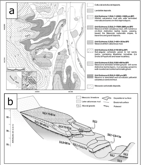
Recent morphological and litho-pedostratigraphic investigations, supported by new radiocarbon, U-series and tephrochronological age determinations, have allowed an update of the Quaternary stratigraphic and chronological framework of the Sulmona basin sequence, as discussed in detail by Giaccio et al. (2009), with the designation of six informal units of lacustrine deposits. A comprehensive, simplified, schematic stratigraphic and chronological framework is shown in Figure 4.1.3.
24 These lacustrine units, separated by erosional surfaces and/or pedogenic levels, have been detected and annotated from the earliest (“Sulmona 6”) to the most recent (“Sulmona 1”). According to Giaccio et al. (2009), the six units can be chronologically attributed to the following time spans: Sulmona 6: >800 ka BP; Sulmona 5: 600 to 400 ka BP; Sulmona 4: 120 to 80 ka BP; Sulmona 3: 80 to 60 ka BP; Sulmona 2: 8 to 2.6 ka BP; Sulmona 1: 2.6 to 1.2 ka BP (Fig. 4.1.3).
The lowermost limit, i.e. >800 ka BP, that was attributed to the oldest analysed lacustrine unit derives from the presence of calcalkaline tephra layers related to the
Fig. 4.1.3 – a) Geological map of the north-eastern sector of the Sulmona basin (numbers refer to the main measured sections reported in Giaccio et al., 2009); b) Scheme of the stratigraphic and geomorphological relationships between the six sedimentary units (SUL6–SUL1) recognised by Giaccio et al. (2009).
a
25 activity of the peri-Tyrrhenian volcanoes which preceded the onset of the activity of the ultra-potassic Roman Comagmatic Province, started at the beginning of the Middle Pleistocene (e.g. Peccerillo, 2005).
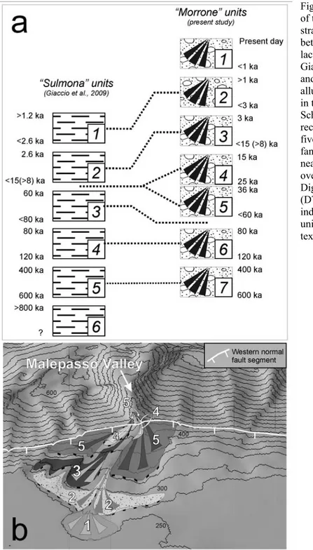
Besides this lacustrine sequence, at least seven units of alluvial deposits, some of which may be morphologically related to the lacustrine ones have been distinguished (Fig. 4.1.4). These are represented by different orders of telescopic and/or superposed alluvial fans, which are mainly fed by the fluvial network that cuts across the Mt. Morrone SW slopes.
Fig. 4.1.4 – a) Scheme of the possible morpho-stratigraphic correlation between the “Sulmona” lacustrine units of Giaccio et al. (2009) and the “Morrone” alluvial units described in the present study; b) Schematic
reconstruction of the five orders of alluvial fan deposits detected near Popoli village, overlying a hillshade Digital Terrain Model (DTM). Numbers indicate the “Morrone” units described in the text.
26 A basic description of the alluvial units (labelled from the oldest, “Morrone 7”, to the most recent, “Morrone 1”) is provided below together with the possible relationship between some of these units and the lacustrine units of Giaccio et al. (2009).
- Morrone 7 (<600 – >400 ka BP) – This is the oldest alluvial unit of the basin that contain volcanic levels (older, “pre-volcanic” alluvial deposits of the basin have been detected and described in other studies, e.g. Miccadei et al., 1998; Gori et al., 2007). This unit corresponds to the “Conoide Superiore di San Venanzio” unit of Miccadei et al. (1998), who attributed these deposits to the Middle Pleistocene. The gravels of this unit are interfingered with the lacustrine sediments of the Sulmona 5 unit.
- Morrone 6 (120 – 80 ka BP) – This unit comprises the deposits described by Radmilli (1984) and Tozzi (2003) that contain a sequence of Paleolithic layers that have been attributed to the Musterian technocomplexes. In peninsular Italy, these Paleolithic layers have been related to a chronological interval from between ca. 120 to 40 ka BP. (e.g. Tozzi, 2003, and references therein). The possible correlation between the Morrone 6 and Sulmona 4 units is supported by the detection of a particular marker, i.e. a tephra layer that is seen for both the alluvial and the lake sediments.
- Morrone 5 (<60 – 36 ka BP) – The alluvial fan that represents this unit is the equivalent of the “Terrazza Alta di Sulmona” (TAS) unit of Miccadei et al. (1998). The wide, northward inclined top depositional surface of the TAS unit is detectable over almost all of the basin and dominates the Sulmona plain landscape (from about 420 m a.s.l. in the southern part of the basin, to about 340 m a.s.l. in the northern basin sector) (Fig. 4.1.1). The correlation between the Morrone 5 and TAS units is supported by the presence of the same reworked tephra layers that have been detected at comparable depths (about 1-2 m) below the top depositional surfaces of each of the units (Fig. 4.1.5). In more detail, this volcanic level is made of sub-mm-sized to mm-sub-mm-sized, grey-black, poorly vesicular scoria with abundant leucite and clinopiroxene, and up to cm-sized phlogopite crystals (see Miccadei et al., 1998).
27 These particular compositional features characterise a cluster of two or more crystal-rich tephra layers that have been recognised in a wide area of the central Apennines, and on the basis of chemical, isotopic and chronological data, they have been attributed to the most recent volcanic activity of the Albano Maar (Colli Albani volcanic district, near Rome) (Narcisi, 1994; Giaccio et al., 2007, and references therein) that was recently dated to between 40 and 36 ka BP (Freda et al., 2006). A radiocarbon dating of a terrestrial gasteropod shell embedded in the reworked tephra of the TAS unit yielded an age of 36610 ±209 cal years BP (estimated calibration, according to Fairbanks et al., 2005), which supports the chronological constraint defined for these deposits.
Moreover, from a morphological point of view, the correlation between the Morrone 5 and TAS units is supported by the alluvial fan of Morrone 5 that is related to a base level that corresponds to the top surface of the TAS unit.
Lastly, the deposits of the Morrone 5 unit unconformably overlie the lacustrine sediments of the Sulmona 4 unit (120-80 ka BP).
- Morrone 4 (L.G.M., i.e. 25-15 ka BP) – The deposits of this unit are morphologically comprised between those of the older Morrone 5 and the younger Morrone 3 (see below). The chronological attribution of this unit is supported by the fact that other alluvial fans, formed during the Last Glacial Maximum (LGM), have been detected in many areas of the central Apennines (i.e. Fucino plain-Valle Majelama, Giraudi, 1992; Campo Imperatore plain, Giraudi and Frezzotti, 1997;
Fig. 4.1.5 – Reworked tephra layer detected within both a) Morrone 5 unit (described in the text) and b) the TAS unit of Miccadei et al. (1998).
28 Corvaro plain, Chiarini et al., 1997; Castelluccio di Norcia plain, Galadini and Galli, 2003). Locally, this unit is represented by slope-derived deposits that are widespread all over the Apennines (Castiglioni et al., 1979; Dramis, 1983; Coltorti and Dramis, 1988), and which result from periglacial erosional/ depositional slope processes that were active during the LGM.
- Morrone 3 (<15 (>8) – 3 ka BP) – This is represented by an alluvial fan, the top depositional surface of which defines a well preserved terrace that seems to be at the same elevation a.s.l. of the shoreline of the paleo-lake that corresponds to the Sulmona 2 unit.
- Morrone 2 (<3 – >1 ka BP) – This unit is represented by alluvial fan gravels, the top depositional surface of which morphologically correlates with the top surface of the Sulmona 1 unit.
- Morrone 1 (>1 ka – present day) – This unit is represented by small alluvial fans related to the present base level of the basin.
The whole sequence of units Morrone 5 to Morrone 1 has been clearly identified where the Malepasso valley (see Fig. 4.1.2 b) opens on the plain. Here, these units are represented by five orders of telescopic alluvial fans (see Fig. 4.1.4 b) – partly already detected by Miccadei et al. (1998) and attributed by the authors to the Late Pleistocene – the eldest of which (Morrone 5 unit) is related to the top depositional surface of the TAS unit while the younger units (Morrone 4 to 1 unit) are embedded in it. In other sectors along the base of slopes – i.e. W and N of Bagnaturo – these units are represented further superposed and/or embedded alluvial fans some of which relate to the top depositional surface of the TAS unit while younger fans overlay it. The different geomorphic setting between the alluvial fans at the Malepasso and Bagnaturo areas is due to fact that, in the former area, the regressive fluvial erosion incised the TAS unit, progressively lowering the base level and thus permitting the formation of subsequent telescopic fans. In the Bagnaturo sector, instead, the top surface of the TAS unit has not yet been significantly incised by fluvial erosion. Owing to this, at this site the alluvial fans that are younger than the TAS unit deposited on its top depositional surface.
29 Although this different geomorphic framework prevented a “one by one” correlation between the Malepasso and the Bagnaturo alluvial fan units, the analysis of stratigraphic sections exposed by quarries near Bagnaturo permitted us to obtain further chronological elements that corroborate the age of the deposition of the Morrone 5 to Morrone 1 units. Indeed, 1) radiocarbon dating of a paleosoil contained within the alluvial fan that is morphologically related to the TAS unit provided an age of 41830±2130 years BP (Fig. 4.1.6 a), and 2) a tephra layer occurring within an alluvial fan that deposited over the top surface of the TAS unit can be related to the “Neapolitan yellow tuff” (Fig. 4.1.6 b), dated at 14200 years BP on the basis of 14C chronological constraints (Asioli et al., 2001; Siani et al., 2001).
These data corroborate the attribution of the units Morrone 5 to Morrone 1 to a time span younger than 60 ka.
Neapolitan yellow tuff
Fig. 4.1.6 – a) Alluvial fan sequence exposed by a quarry near Bagnaturo, at the base of the Mt. Morrone SW slopes; b) Tephra layer, associated to the “Neapolitan yellow tuff”, occurring within alluvial fan deposits near Bagnaturo
overlaying the TAS unit.
a
30
Evidence of Late Quaternary tectonics
- Pacentro site (Fig. 4.1.1, site 1)
In the southern sector of the SW slopes of Mt. Morrone, the fault plane of the western segment can be detected almost at the base of the slopes, close to the village of Pacentro. Kinematic indicators detected along the fault plane (Fig. 4.1.7) as slickenlines, with a pitch angle from 72° to 82°, lunate fractures (Petit, 1987), and the synthetic shear planes in the fault zone all indicate mainly normal kinematics of the fault segment, with a minor sinistral oblique component.
Here, the alluvial fan deposits of the Morrone 7 unit are exposed about 1.5 km away from the southernmost tip of the fault branch.
The fan has been fed by the Mileto valley, a deep V-shaped fluvial incision that is perpendicular to the slope (Fig. 4.1.8).
Fig. 4.1.7 – Schmidt net diagram on which the synthetic shear planes detected in the fault zone (black bows) and the pitch of the slickenlines (black dots) are plotted
Fig. 4.1.8 – Alluvial fan deposits of the Morrone 7 unit outcropping within the Mileto Valley, upslope of the village of Pacentro.
31 The deposits are displaced along the fault branch. In the footwall of the fault, the deposits lie on the bedrock. They can be detected within the Mileto Valley incision, at an elevation ranging between 1,100 m a.s.l. (i.e. the apex of the fan, where the layers show a steep angle of 25°) and 825 m a.s.l. (Fig. 4.1.9).
At this elevation, the layers have a sub-horizontal attitude (about a 12° dipping) and are clearly truncated towards the plain due to the fault activity, such that they are at present suspended over the basin bottom (Fig. 4.1.10).
Fig. 4.1.9 – Alluvial fan deposits of the Morrone 7 unit detected within the Mileto Valley incision, in the western fault segment footwall. The white dashed line highlights the layer attitudes that in the distal part of the deposits become sub-horizontal.
Fig. 4.1.10 – The Morrone 7 unit deposits lying on the carbonate substratum (the white dashed line marks the contact between the deposits and the bedrock) in the fault segment footwall. The layers are clearly suspended over the present basin bottom and truncated by the fault movements.
NE
32 In the hanging wall sector, instead, the base of the fan can be detected between 667 m and 675 m a.s.l. (part of Pacentro village has been built on it) (Fig. 4.1.11), overlying a huge paleo-landslide accumulation known as “Pacentro paleolandslide” (Miccadei et al. 1998; 2004). The sub-horizontal attitude of the layers (about 10° SW dipping) suggests that the deposition in this area occurred close to the local base level.
The fault segment places the alluvial fan sediments in contact with the carbonate substratum.
The vertical offset affecting the base of the Morrone 7 unit across the western fault segment (Fig. 4.1.12 )can therefore be estimated at about 160 m (Fig. 4.1.13).
Fig. 4.1.11 – Alluvial fan deposits of the Morrone 7 unit close to Pacentro, outcropping in the hanging wall sector of the western fault segment. The white dashed lines highlight the sub-horizontal attitude of the layers.
Fig. 4.1.12 – Schematic geological profile showing the offset of the Morrone 7 units due to the western fault segment activity.
33 - Popoli-Malepasso Valley site (Fig. 4.1.1, site 2)
The complete sequence of the units Morrone 1 to 5 has been detected at this site (Fig. 4.1.4 b), where the Malepasso Valley opens on the plain (see Fig. 4.1.2 a). Here, the westernmost fault branch is detectable at the base of the slope. The kinematic indicators collected along the fault plane in this area (Fig. 4.1.14) as slickenlines, with a pitch angle ranging from 76° to 83°, and the synthetic shear planes in the fault zone confirm mainly normal kinematics with a minor sinistral oblique component.
Fig. 4.1.13 – Vertical displacement of the Morrone 7 unit deposits due to the fault segment movements. The offset can be quantified in about 160 m.
Fig. 4.1.14 – Schmidt net diagram on which the synthetic shear planes detected in the fault zone (black great circles) and the pitch of the slickenlines (black dots) are plotted.
34 The fault has displaced the alluvial fan deposits of the Morrone 5 and 4 units (Fig. 4.1.15, inset).
The sediments of these units are detectable both in the hanging wall and in the footwall. The top depositional surface of the unit Morrone 5 is displaced along the fault by about 20 m (Fig. 4.1.16). Moreover, the layers of the alluvial fan are clearly truncated by several secondary fault planes.
In the proximal part, the Morrone 4 unit is represented by a flat alluvial terrace along the left flank of the Malepasso valley incision. The fault activity has displaced this terrace by about 7 m (Fig. 4.1.16).
Fig. 4.1.15 – Digital Terrain Model showing the sedimentary units detected at site 2 in Fig. 4.1.1; the Morrone 4 and 5 units are clearly displaced along the western fault segment (inset).
Fig. 4.1.16 – (Site 2 in Fig. 4.1.1) Vertical displacement affecting the top depositional surface (indicated by the triangles) of the Morrone 4 and 5 units, quantified in about 7 and 20 m, respectively; on the Schmidt net diagram (inset) the synthetic shear planes detected in the fault zone (black great circles) and the pitch of the slickenlines (black dots) are plotted.
0 m 500
35 - Popoli-Sant’Anna Valley site (Fig. 4.1.1, site 3)
At this site, the western fault segment affects the base of the slope. The kinematic indicators detected along the main and the secondary fault planes (Fig. 4.1.17), i.e. slickenlines, with a pitch angle ranging from 75° to 80°, and the synthetic shear planes in the fault zone confirm a mainly normal kinematics.
The Sant’Anna Valley is a deep fluvial incision that is almost perpendicular to the main slope and that opens onto the plain near the village of Popoli (Fig. 4.1.2 a). This incision cuts the deposits of the Morrone 7 and 6 units, which are only detectable in the footwall of the main fault. Nevertheless, the sediments of the Morrone 7 unit are displaced by about 13 m along a secondary fault plane (linked to the main one). The offset was evaluated by correlating the erosional surface that separates the deposits and the carbonate bedrock across the fault (Fig. 4.1.18).
Several synthetic, secondary fault planes truncate the layers of the Morrone 6 and 7 units (Fig. 4.1.19 a, b), that locally display a counter-slope tilting (Fig. 4.1.20).
Fig. 4.1.17 – Schmidt net diagram on which the synthetic shear planes detected in the fault zone (black great circles) and the pitch of the
slickenlines (black dots) are plotted. Fig. 4.1.18 – Left flank of the Sant’Anna Valley incision, along which the vertical offset that affects the deposits of the Morrone 7 unit, due to the western fault segment activity, is shown (Fig. 4.1.1, site 3).
NE
SW
36 Moreover, the almost flat depositional surface at the top of the alluvial fan is affected by a fault scarp, indicating a 12-13 m vertical offset along these secondary splays (Fig. 4.1.21).
a
b
Fig. 4.1.19 – Synthetic fault planes (indicated by the white triangles) that displace the deposits of the Morrone 6 (a) and 7 (b) units.
Fig. 4.1.20 – Deposits of the Morrone 6 unit displaying a counter-slope attitude (marked by the white dashed line).
Fig. 4.1.21 – Vertical displacement of about 10-11 m that affects the top surface (delimited by the white dashed lines) of the Morrone 6 unit deposits.
37 Moreover, the Morrone 6 unit deposits and some sediments younger than the Morrone 6 unit (as they are embedded in it) are displaced along a fault (already reported by Miccadei et al., 1998) parallel to the Sant’Anna Valley, WSW-ENE trending and almost perpendicular to the main Mt. Morrone normal fault segments (Fig. 4.1.22 a, b).
The kinematic indicators collected along the fault plane indicate a prevailing dextral strike-slip motion of the tectonic structure, with a minor normal component. The structural setting suggests that it represents a transfer fault – probably a breached relay ramp (e.g. Peacock and Sanderson, 1994; Childs et al., 1995; Peacock, 2002; Walsh et al., 2003) – that connects the main Mt. Morrone fault branches, and that was at least active after the deposition of the Morrone 6 unit. The lack of synchronous deposits that can be correlated across the fault prevented the possibility of estimating the offset. Moreover, according to Gori et al. (2006; 2008), a certain amount of gravitational displacement along this transfer fault can be hypothesised, since this tectonic structure represents the lateral boundary of a large-scale mass movement that affects the slopes.
- Le Svolte di Popoli “archaeological” site (Fig. 4.1.1, site 4)
a
b
Fig. 4.1.22 – a) Deposits of the Morrone 6 units (the layers are marked by the yellow dashed line) displaced along the WSW-ENE trending fault (the plane is indicated by the red arrows); b) secondary fault planes (indicated y the red arrows), related to the main WSW-ENE trending fault, along which sediments younger than the Morrone 6 unit deposits are displaced and dragged (inset).
NW
SE
38 Here, the Morrone 6 unit is displaced by about 5 m along the main western fault branch (Fig. 4.1.23). This offset can be estimated on the basis of the displacement affecting a reworked volcanoclastic level, present both in the footwall and in the hanging wall.
The outcrop investigated is located very close (a few tens of metres) to the northern tip of the fault, where the segment ends against a structural feature known as the “Avezzano-Bussi fault system” (see Fig. 2.1.3), which is perpendicular to the Mt. Morrone fault system (i.e. ENE-WSW trending) (Galadini and Messina, 2001; Cavinato et al., 2002) (Fig. 4.1.24).
This fault was active in this sector between the Pliocene and the Early Pleistocene, and its exhumed plane is exposed here. This framework has implications in terms of estimating the slip rate, as discussed in the next section.
Fig. 4.1.23 – (Fig. 4.1.1, site 4) Deposits of the Morrone 6 unit displaced along the northern tip of the western fault segment (indicated by the white triangles).
Fig. 4.1.24 – Fault plane (indicated by the red arrows) related to the “Avezzano-Bussi fault system” of Galadini and Messina (2001).
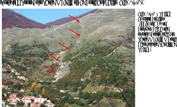
39 - Il Vellaneto and Bagnaturo-Colle delle Vacche sites (Fig. 4.1.1, sites 5 and 6, respectively)
Both the western and the eastern fault segments place the carbonate substratum rocks in contact with LGM slope-derived deposits, which are ascribed to the Morrone 4 unit. Along the western fault segment, contact between the carbonate bedrock and these deposits has been seen at the Il Vellaneto site (Fig. 4.1.25), along the middle part of the slopes, northeast of Marane (see Fig. 4.1.2 a).
For the eastern fault branch, instead, tectonic contact has been detected at the Colle delle Vacche site, (Fig. 4.1.26) along the higher part of the slopes, east of the village of Bagnaturo (see Fig. 4.1.2 a).
Fig. 4.1.25 – Last Glacial Maximum deposits (the layers are marked by the white dashed line) placed in contact with the carbonate substratum by the
westernmost fault segment (site 5 in Fig. 4.1.1).
Fig. 4.1.26 – Last Glacial Maximum deposits placed in contact with the carbonate substratum by the eastern fault segment (site 6 in Fig. 4.1.1). The layers of the deposits (highlighted by the white dashed lines) are clearly truncated by the fault branches activity. A close up image of the fault zone is shown in inset, where the fault plane is marked by red arrows and the layers of the deposits are highlighted by the yellow dashed line.
40 In some places, the layers of the LGM deposits show evidence of dragging due to the fault movement.
The kinematic indicators collected along the plane of the eastern branch (Fig. 4.1.27), i.e. slickenlines, with a pitch angle ranging from 78° to 85°, lunate fractures (Petit 1987) (Fig. 4.1.28) and the synthetic shear planes in the fault zone, suggest that this segment is also characterised by mainly normal kinematics, with a minor oblique left-lateral component.
The lack of synchronous landforms and/or deposits that can be correlated across the eastern fault has hindered the definition of the vertical offset. However, it should be noted that the estimate of the offset across this segment of displaced geologic/ geomorphic features has to be considered with caution, in order to define a tectonic slip rate. Indeed, the sector of the SW slopes of Mt. Morrone between the main fault branches has been affected by large-scale gravitational movements, which have already been detected by Ciccacci et al. (1999) and Miccadei et al. (2004), and described by Gori et al. (2006; 2008).
4.2 The Maiella-Porrara normal fault system
As reported in section 2.1, the sector comprised between the Maiella Massif, Mt. Morrone and Mt. Porrara was the origin of high-magnitude historical earthquakes that occurred in 1706 (Maw = 6.6) and in 1933 (Maw = 5.7) the causative faults of which is still under debate.
Geological and geomorphological surveys carried out in this area permitted us the Fig. 4.1.27 – Schmidt net diagram on
which the synthetic shear planes detected in the fault zone (black great circles) and the pitch of the
slickenlines (black dots) are plotted.
Fig. 4.1.28 – Lunate fracture detected along the plane of the eastern fault segment.
41 identification of Late Quaternary normal faulting in this area.
We have detected normal fault segments 1) in the southern sector of the Maiella Massif, here the Palena Fault, and 2) along the western slope of Mt. Porrara, here the western Porrara Fault, a relief located south of the Maiella relief. Although these faults have already been mapped in the past (Donzelli, 1969; Vezzani et al., 1993; Vezzani and Ghisetti, 1998), their Late Pleistocene-Holocene activity has not been described before.
4.2.1 Field data
These tectonic structures appear to branch from a northern fault segment that propagates towards the SW from the Mt. Morrone normal fault system (Fig. 4.2.1, 4.2.2).
42
Fig. 4.2.1 - Digital Terrain Model on which red lines mark the segments of the Mt. Morrone normal fault system as described in the present work; the yellow lines, instead, mark the fault segments detected in the area comprised between Mt. Morrone, Maiella Massif and Mt. Porrara.
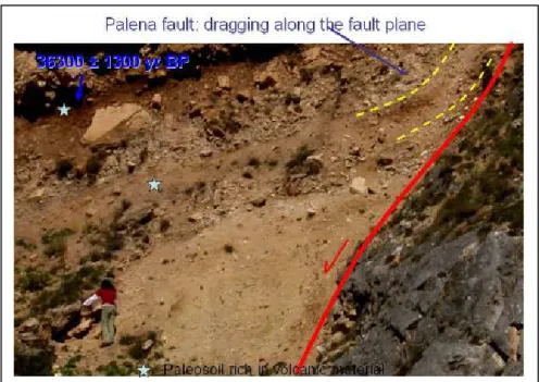
43 The Palena fault
The Palena Fault is formed by a major N110°-120° trending fault segment and by some minor synthetic sub-parallel splays. The main fault crosses the slopes in the southernmost sector of the Maiella ridge at right angles (Fig. 4.2.3).
It is also transverse to the axial trace of the Maiella anticline close to the southern plunge.
6
Fig. 4.2.2 – Three-dimensional images of the southern Maiella Massif and Mt. Porrara area created by draping aerial orthophotos (1:10.000 Scale, from C.G.R. Parma, Italy) over digital topography (40 m pixel resolution, from Regione Abruzzo, Italy) with sun direction from the SE and sun angle = 45°. The red lines mark the fault segments of the Maiella-Porarra fault system. The blue dashed line marks the Caramanico fault-line scarp as described by Ghisetti an Vezzani (2002) while the yellow dot-dashed line marks the “Fondo di Maiella” landslide scarp (see the text). The numbers (1-4) indicate the site described in the text.
Fig. 4.2.3 – Palena Fault scarplet (indicated by red arrows) along the south-eastern slopes of the Maiella Massif, close to the of village Palena.
44 This fault segment was observed in the field between the village of Palena (close to the Aventino river thalweg) and the Guado di Coccia saddle (see Fig. 4.2.4).
Based on geomorphic evidence, it can be extended westward along the western Maiella slope, up to ca. 1.5 km east of Campo di Giove. Hence a total length of about 7 km can be evaluated for the entire fault segment.
These SSW-dipping planes are usually associated with bedrock scarps. Along the scarps, the exposed faults are responsible for the displacement of the Mesozoic-Cenozoic carbonate bedrock that outcrops both in the footwall and in the hanging-wall blocks. This geomorphic feature suggests that erosional selective processes have had no influence on the formation of the scarps (Fig. 4.2.5).
Carbonate bedrock
Fault plane
Fig. 4.2.4 – Palena Fault scarplet (indicated by red arrows) close to the Guado di Coccia saddle, along the uppermost part of the Maiella relief.
Fig. 4.2.5 – Palena fault scarplet. The carbonate substratum crops out both in the hanging wall (indicated by the white arrow) and in the footwall (indicated by the black arrow) of the fault.
45 Moreover, the fault scarps generally show very little degradation and interrupt the continuity of the Maiella eastern slope. Since the regular profile of Apennine slopes results from the last significant morphogenic phase, which is generally attributed to the Last Glacial Maximum, an age of post-18 kyr BP can be attributed to the scarp formation and the related fault activity (see Galadini and Galli, 2000; Roberts and Michetti, 2004, for a full discussion on this topic).
Locally, Quaternary continental deposits are juxtaposed against the bedrock fault plane (Fig. 4.2.2, site 1). Erosion of these deposits has produced exposures of the fault plane that are up to 20-30 m high (Fig. 4.2.6), and very clear kinematic indicators can be detected (Fig. 4.2.7).
The fault-slip data show nearly pure dip-slip normal movements (Fig. 4.2.7 a) probably superposed on slickenlines indicating sinistral oblique motions (Fig. 4.2.7b).
Fault plane
N N
N NNN
Fig. 4.2.6 – The 20-30 m high exposure of the Palena Fault plane ca. 700 m NW of Palena village (Fig. 4.2.2, site 1). Here, the fault juxtaposes Messinian gypsum-arenites in the hanging wall, against Eocene-Oligocene calcgypsum-arenites in the footwall.
a
b
Fig. 4.2.7 – Schmidt net diagrams on which synthetic shear planes detected in the fault zone (black great circles) and the pitch of the slickenlines (black dots) are plotted, related to: a) dip-slip normal movements and b) to sinistral oblique (pre-Quaternary) kinematics.46 These dip-slip movements provide the principal axis of extension, trending about. NNE-SSW.
This extension is consistent with deformation of the Late Quaternary deposits, which have been displaced and dragged by the fault activity, and it appears consistent with the extensional deformation presently acting in the chain (e.g. Galadini, 1999; Pizzi et al., 2002).
In contrast, the earlier, left-lateral, strike-slip striations probably result from the Pliocene fault motions that were related to the formation and evolution of the Maiella thrust-related anticline. The left-lateral movement of the fault is, indeed, kinematically consistent with the NE-SW-oriented main axis of compressive stress that was responsible for the formation of the Apennine thrust-belt. On the whole, the Palena Fault represents an inherited Pliocene syn-orogenic sinistral-oblique structure that was reactivated with nearly pure dip-slip normal motions during the Quaternary. The contact between the carbonate bedrock and Quaternary slope-derived deposits can be observed ca. 1 km upslope (NW) of Palena, at an elevation ranging between 1,025 m and 1,075 m a.s.l. (Fig. 4.2.2, site 1). Here, the sediments are clearly displaced (Fig. 4.2.8) and dragged (Fig 4.2.9) along the fault plane.
Fig. 4.2.8 – Late Pleistocene slope-derived deposits (see the text) displaced along the Palena fault. The green and blue dashed lines mark the attitude of the layers while the red arrows indicate a fault plane that affects the sediments.