1
A
Al
lm
ma
a
M
Ma
at
te
er
r
S
St
tu
ud
d
io
i
o
ru
r
um
m
–
–
U
U
ni
n
iv
v
er
e
r
si
s
it
tà
à
d
di
i
B
Bo
ol
lo
og
g
na
n
a
PhD Program in
International Cooperation
and Sustainable Development Policies
XXIV Cycle
AGR/01
07/A1
On land management: landowners' attitudes
to land and farming in Valdera, Tuscany
Stefano Orsini
PhD Coordinator Supervisor
Prof. Andrea Segrè Prof. Gianluca Brunori
2
List of contents
Chapter 1
Introduction...1
1.1 Setting the issue: urban-rural relationships...1
1.2 Research questions...5
1.2 Definitions...6
1.2.1 Urbanisation...6
1.2.2 Structural changes in agriculture...8
1.2.3 Impacts of urbanisation on agriculture...10
1.3 Conceptual framework...12 Chapter 2 Research design...15 2.1 Methodology...15 2.2 Procedure...18 Chapter 3 Regulating and managing private farmland. Case studies from Valdera, Tuscany...21
3.1 Introduction: rural areas under pressure....
.
...213.2 Study area and context...23
3.2.1 The planning context...25
3.3 Case studies...28
3.3.1 Case study 1 – Stressing outdoor recreation in a periurban context...28
3.3.2 Case study 2 – “Land in between”...31
3.3.3 Case study 3 – Industrial development “in the near future”...33
3.4 Discussion...35
Chapter 4 Explaining land management decisions to understand local landscape functions and change. Some insights from Tuscany...41
4.1 Introduction...41
4.2 The explanatory framework...43
4.3 Landowners relational typologies...44
4.4 The interviews...45
4.5 The study area...47
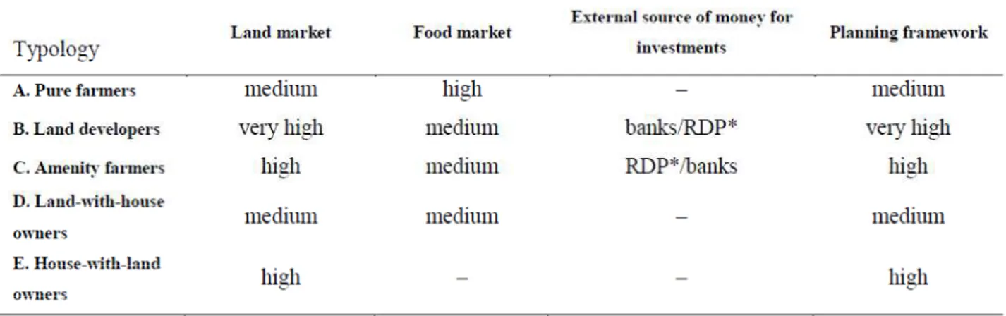
4.6 Typology of landowners...49
4.6.1 Summary and Integration...59
4.7 Discussion...60
Chapter 5 Landscape polarisation, hobby farmers, and a valuable hill in Tuscany: understanding landscape dynamics in a periurban context...63
3
5.1.2 Tuscany and traditional landscapes...65
5.2 Case study: emerging polarised landscape experiences...67
5.2.1 Material and methods...67
5.2.2 Place and context...69
5.2.3 Experiencing Treggiaia hill land and farming...75
5.2.4 Landowners and agriculture in the lowland...78
5.2.5 Summary and Integration...79
5.3 Discussion...80
Chapter 6 Conclusions...83
6.1 Key findings...83
6.2 Scientific contribution and recommendation for further research...87
Appendix 1 – Questionnaire: Interviews with landowners...91
References...95
4
Chapter 1
Introduction
1.1 Setting the issue
One of the most apparent processes which have characterised urban-rural relationships in Western societies during the past 50 years is the expansion of urban areas (UN, 2008; EEA, 2010). From the spatial development perspective, it causes a high degree of changes in land use and land cover. However, physical urban growth only represents one perspective of urbanisation, which can be understood in terms of land use change, as well as in terms of lifestyle and functional changes (Basile & Cecchi, 2001), which may or may not result in physical urban growth and land use change. Indeed physical encroachment is only a limited part of the urbanisation, nor do the theories of cycles of urbanisation, suburbanisation and counter-urbanisation (Champion, 2001; Antrop, 2004) completely describe current urban-rural relationships (Madsen et al., 2011). In my thesis I especially focus on the above mentioned second aspect of urbanisation, that is on functional and lifestyle changes taking place in the countryside.
Following Primdahl et al. (2010), I argue that the intersecting dynamics of structural changes in agriculture and urbanisation need to be studied in order to better understand changes in rural landscapes.
Changes in population composition, demands for recreation and houses out of city centre, changes in agricultural business structures have contributed to make urban-rural borders more and more permeable physically as well as socially. Transition, mixture (or hybrid) and change – of population, land use, property structure – became key notions underlying urban-rural discourses.
The agricultural landscape component of these changes has often been considered as a reflexive backdrop to urban development. Concern has been perhaps most broadly apparent in the attention to the urban side of the issue, to urban sprawl containment and the expressed aspiration for smart growth (Goetz et al., 2010). Other complementary concerns for urbanisation have often dealt with the loss of amenity and visual qualities of rural areas, which have been valued for the recreation of urban populations: for instance, while the planners' main purpose for London's Metropolitan Green Belt was urban containment, its merit for many
5
people has been not only related to the control of urban development, but also for the maintenance of the 'rural character' of the landscape (Munton, 1983).
Most of the literature on the impact of urbanisation and growth management focuses on broad understanding of the importance of the physical boundaries for urban containment, which, however, resulted to be not always effective in avoiding unsympathetic or non-essential development, conflicts and contestations between development interests and different local interests (Harvey & Works, 2002). Concerns for landscape amenity and visual qualities as well, with a focus on green space preservation for urban people, have represented an important issue in academic and policy circles (Caspersen et al., 2006); yet, they only slowly spread to farming landscapes where agriculture as productive and economic activity represents a significant component. This was also due to the agricultural over-production that strongly characterised the Western countries food system during the past decades.
Nowadays, concerns over agriculture and urbanisation start to deal with the loss of agricultural productivity as well, as the result of the conversion of productive land from agriculture to other uses. The concern is increasingly expressed in terms of long-term food production potential, within the food security and land security discourses (EEA, 2010).
Other consequent and similar concerns are related to changes in landscape structure, environmental and ecological problems due to urban encroachment, land fragmentation, land neglecting and so forth.
In the following sections I will illustrate how urbanisation impacts on agriculture and farming landscapes. I roughly anticipate that urbanisation in periurban areas and in the rural hinterland may contribute to the weakening of agricultural viability over time in a number of ways.
Urbanisation acts on agriculture in a complementary way with other forces such as changing values regarding lifestyles, employment opportunities, market, family structures, and so on (Bryant, 1984; Bryant, 2011). Nowadays, at the extreme, several forces might be interpreted as complementary. For example, complementary relationships stem from the effect of labour withdrawn from agriculture due to urban labour demand; in this case one effect could be the decision of landowners to contract out the land management to retired or local farmers. Similarly, difficulties to keep farming economically viable may combine with 'hidden urbanisation', i.e. functional change and conversion of buildings (van den Vaart, 1991), pursued by the landowners or even farmers themselves, in order to capitalise on development opportunities. Another example stems from the
6
effect of the influx of new types of rural inhabitants/landowners, similar to counter-urbanisation, who may perform very different land management attitudes, ranging from active land stewardship, ecological restoration and production of vegetables for self-consumption, to contracting out land management or land neglecting.
These examples would suggest that the management challenge for agricultural landscape under urban pressure is twofold.
First, the range of forces affecting rural areas serves to develop a number of functions, spanning from agricultural production to residential and recreational uses, which leads us to ask: what are the implications for agricultural land use? The increasing urbanisation of the countryside makes owners focus on new interests, sometimes at the expense of traditional agriculture. Indeed rural land is supposed to provide, and is increasingly valued in term of, goods and services other than the agricultural ones (Munton, 2009). Previous studies have proved that land use pattern, i.e. landscape structure (land use and landscape elements) changes more slowly than the functions on the properties do (Marsden & Munton, 1991; Busck et al., 2006; Bomans et al., 2010). However, the socio-economic processes affecting rural areas around the Western world countries (number increase of owners engaged in other activities and the related decrease of full-time farmers) may determine changes in landscape structure and environmental effects in a medium-long term perspective.
The second challenge deals with the raise of diverse set of relationships between land management, land ownership and farming. This issue is particularly complex and involves a number of situations that can lead to different landscape outcomes. Landowners develop their holdings according to their interpretation of constraints, options, and their own values (Lowe et al., 1992). Concretely, the landowner, the land manager and the professional farmer (full-time or part-time farmer) may or may not coincide with each other: landowners are sometimes also land managers or/and farmers. Landowner who relies on source of income other than the agricultural one may decide, for instance, to contract/rent out the management of his land, and to reduce the labour input and seek simple farming or management systems (Lobley & Potter, 2004; Munton, 2009). A recent trend in Western countries is the increase in the number of 'lifestyle' residential landowners as people from non-agricultural backgrounds purchase usually small farm holdings (Lobley, 2002; Bohnet, 2003; Gill et al., 2010; Milburn et al., 2010). In this case they may act as hobby farmers who actively manage and grow the land for different reasons – the liking for ecological restoration, landscape 'beautification', food self-sufficiency ideas – or they may conceive the countryside
7
just as a place to live in (Primdahl, 1999), and keep the land uncultivated or contract out its management. Finally, challenges to keep the land farmed or managed is posed by expropriation of property rights when land rights are (still) not expropriated. Expropriations of private ownership represent relatively radical types of interventions on private land, taking place on grounds of public interests in the specific area (usually for infrastructures development): the high degree of uncertainty presumed to occur in advance of the specific infrastructure development can represent a shortening planning horizons for farm investments (Sinclair, 1967; Bryant, 1984; Qviström, 2007).
According to these two points and the relevant literature (Primdahl, 1999; van den Vaart, 2005; Bohnet, 2008), it seems evident that landowners play a crucial role for landscape dynamics as they are the key actors who take decisions on landscape structures and functions – termed as landscape management decisions throughout this thesis (or, alternatively, as land management decisions): landowners develop their holdings according to their interpretation of constraints, options, and their own values (Lowe et al., 1992). It is argued that the meaningful engagement of private landowners is an important input to successful policy delivery, as it holds the promise of revealing points of agreement and disagreement between the policy maker and those who will be the subject of policy intervention (Primdahl, 1999; Cocklin et al., 2007).
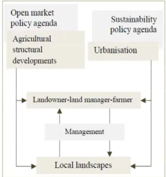
Figure 1.1 Key drivers affecting rural landscape (Inspired by Primdahl et al.,
2011, and modified by the author).
The combined effects of structural developments in agriculture and urbanisation are expressed in diverse way within different types of landscape system, and are mediated through the responses and attitudes of individual actors.
8
Given the importance of local landowners, the sustainability policy agenda (land use legislation and spatial planning) and the market policy agenda along with agricultural policies (Figure 1.1), do not impact landscape management decisions in only one way everywhere, since local social, economic, cultural and institutional context will impact on land management practices. This means that the overall drivers of land use change have to be seen in a more local context, which is subject to spatial and temporal (contextual) variability (Jongeneel et al., 2008). It is therefore useful to take landowners' decisions as a point of departure when a deep understanding (and forecasting) of the impacts on landscape is required, for instance when designing and implementing policy related to agricultural landscapes. This and other problems will be addressed and discussed throughout this thesis
On the background of these lines of argumentations, in this thesis I try to undertake a more detailed look at how landowners experience rural landscape and how they conceive landownership and farming, thus taking decisions on land property. The research questions I address are:
• how and why do landowners differ in their attitudes towards agriculture, land-based investment choices and in their involvement in active farming
(landscape management decisions)?
• what are the main implications for public planning and regulation?
I carried out interviews with landowners of the case study area, given their prominent role within the research aims and design. In the next chapter the methodological aspects of this research are presented.
Throughout this thesis I will use the terms 'landowner', 'farmers' and/or land managers as interchangeable when they coincide with each other (which will be specified in the text).
The research focuses on how the decision making of landowners is determined by economical functions and social meaning of land. The research problems raised by the investigation seemed to be relevant to land system change studies and policies: explaining the changes in socio-economic system may help to understand the conditions that determine land use change.
For example, in periurban areas or, more generally, in areas characterised by the shifts in the use of land areas from traditional farming activity to highly dynamic land uses, the concentration of production on a few large full-time farms, or the attitude of absentee landowners (often with 'urban' background and 'urban'
9
source of income) to contract out land management, have increasingly emerged throughout the Western world countries (Zasada, 2011). It is also clear that landscape decisions are increasingly less related to agricultural production (Marsden & Munton, 1991; Busck, 2002). Thus, increasing attention needs to be paid to non-production values of the agricultural landscape (consumption and conservation) along with the landscape effects. What could be the effects on agricultural landscape structure in the long run?
In order to answer this and similar questions, and to avoid drastic and unexpected land use changes (such as landscape homogenisation, land abandonment and the likely urban growth), researchers as well as planners and politicians need to firstly understand the rationales behind landowners' decisions and to design policies accordingly.
1.2 Some definitions
1.2.1 Urbanisation
Urbanisation means urban expansion – as expressed by the concept of urban sprawl – and land (usually agricultural land) consumption for recreational business and residential purposes (Primdahl & Swaffield, 2010). More broadly speaking, it can be interpreted as a process that creates various kinds of pressure affecting the countryside (Bryant, 1982), or according to Primdahl and Swaffield (2010) as consumption of agricultural land for uses other than agricultural production.
Antrop (2000: 258) defines urbanisation as “a cultural and sociological change caused by the transformation of rural life styles into urban like ones”, acknowledging thus the importance of the socio-economic characteristics of different areas and the patterns of urban-rural migration to interpret recent land dynamics.
The tangible aspect of urbanisation, i.e. spatial growth, is often associated with urban sprawl, which has been defined by the EEA (2006) as “the physical pattern of low-density expansion of large urban areas, under market conditions, mainly into the surrounding agricultural areas” (EEA, 2006: 6). Agricultural landscapes are deeply eroded by urban development. The economic basic for agriculture is very often weaker than the investment power of industrial and urban sectors (Caspersen et al., 2006; Abrams & Gosnell, 2012). Despite this, agriculture is still the largest land-user in most OECD countries (OECD, 2003).
10
Urbanisation is driven by a number of socio-economic factors, as fully reported by the European Environment Agency (EEA, 2006; EEA, 2010). The loss of agricultural land is very often related to diffuse sprawl of residential areas, sport and leisure facilities and highway construction. aggiungere da report
A rich literature documents the urbanisation problems and challenges taking place in the countryside, which are increasingly subjected to urban pressure. Indeed rural landscapes in many developed countries have been experiencing major transformations. On the one hand, the expansion of urban areas into the surrounding landscape entails the transformation of land use, population composition and business structures, on the other hand these trends conflict with demands for food production and recreation.
This is especially true in periurban areas which represent dynamic landscapes, areas of tensions and conflicts, with frequent clashes of interests as many, often contradictory, demands are made on limited land resources.
Recently the use of the term ‘periurban’ to describe urbanisation of rural areas has become more frequent. In line with Briquel and Collicard (2005), who take a broader view, I use this term within my thesis to identify rural areas that are subject to the influence of a nearby city or town, often marked by the development of hobby farms, second homes etc. Thus, these developments are also characteristic of counter-urbanisation, which can be defined as the population migration from urban to rural areas (Antrop, 2004). However, the source of development, which in the case of counter-urbanisation is migration from urban to rural areas, might be different in peri-urban areas. The emergence of periurban areas can also be related, for instance, to the notion of hidden urbanisation (see page 4 of this chapter), or to suburbanisation, that is the migration from the city centre to the city edge (urban fringe).
Within this thesis I often use the terms 'periurbanity', 'periurban areas' and 'periurbanisation' as synonymous of the general term 'urbanisation', to identify the process of consumption of agricultural land for uses other than agricultural production. Thus I will avoid to use the terms of counter-urbanisation and suburbanisation as the delimitation between urban and rural becomes a difficult task involving a lot of uncertainty and it is very unlikely that land zoning borders remain a stable definition (Antrop, 2004).
General notion of 'periurbanity' is often associated and paralleled with the Italian ideas of Città Diffusa – i.e. diffuse cities – (Indovina, 2002). According to some relevant Italian literature, periurbanity can be conceived as the result of urban sprawl even in rural areas which are far from the urban centre; in this case
11
the urbanisation is an endogenous process taking place in the countryside because of development projects within rural areas, migration of urban people, agricultural marginalisation, etc. (Merlo, 1999; Esposti, 2001; Abbozzo & Martino, 2004).
According to Pascucci (2007), periurban areas became physical and socio-economic spaces where both urban and rural features and processes coexist. When analysing and designing policies, this requires to go beyond the urban-rural dichotomy and to consider places, increasingly hybrid places, in a urban-rural continuum. It is more and more felt that contemporary highly dynamic land systems, not only those close to urban centres but even in the rural hinterland, need to be approached and theorised as a whole, i.e. as an urban-rural continuum, since the 'urban' and 'rural' discrete spatial categories may result to be misleading in contemporary land use studies and planning (Pahl, 1966; Bryant, 1982; Saraceno, 1994; Champion & Hugo, 2004; Pascucci, 2007; Gant et al., 2011).
The current attention to the urbanisation discourses is particularly due to the situation that countries across Europe are facing in relation to agricultural soil consumption, both at the edges of the town and cities and in rural areas. Indeed, in Europe, in 2000-2006 about 1000Km2 of agricultural, forest and other semi-natural and semi-natural land was covered every year by urban and other artificial surface (EEA, 2010). Among European countries, in 1990-2005 Italy lost 17% of its total utilised agricultural areas; Germany lost 2% of its national UAA, Spain 3%, France 6%, The Netherlands l6% (Eurostat, 2007). Overall, this trend of agricultural surface reduction is accompanied by holdings decrease and regular agricultural labour forces decrease (Eurostat, 2007). The number of people directly engaged in agriculture is diminishing, and rural-based populations in OECD countries are normally less than 10% of the total population, with many residents in rural areas working in services, tourism and other non-agricultural activities (OECD, 2003). This agricultural land reduction is not always the direct result of urban expansion, but is also the result of a social and institutional marginalisation, which may or may not cause physical urban growth (Torquati & Giacchè, 2011).
1.2.2 Structural changes in agriculture
The concept of agricultural structural changes has a variety of interpretation in the academic and policy literature, sometimes being used as synonymous of the less sectorally specific concept of rural restructuring. Following Bohnet et al. (2003), Potter and Lobley (2004), in this thesis I use the term agricultural structural changes to describe the adjustments being made within existing farm
12
households in order to cope with a changing policy and market context. With the term changes to farm structures I mean the reconfiguration of the land holding pattern due to the exit of farmers, land amalgamation and the entry of newcomers (Bohnet et al., 2003).
There are some common processes within agriculture in Western countries too: literature documents, for instance, that in England (Savills, 2001; Lobley & Potter, 2004), Denmark (Primdahl & Kristensen, 2011), Sweden (Stenseke, 2006), Belgium (Bomans et al., 2010), Australia (Hamblin, 2009) structural trends in agriculture are more and more characterised by the polarisation between large and few farm business, and an increasing number of smaller farms which are often part-time or hobby farms. In the EU-15, 45% of farm households have sources of income other than agriculture (Linares, 2003).
Interestingly, increase of part-time and hobby farming is associated with areas close to the city centre, that we can called periurban areas (which is usually called 'the rural-urban interface' within the American literature), that often seem to attract newcomers with little relation to agriculture as traditional commercially driven activity, such as hobby farms and lifestyle farms (Johnston & Bryan 1987; Heimlich & Anderson 2001). In these areas, the future of farming and the conversion of farmland to non-farm purposes has been a longstanding policy concern for over 40 years (Ilbery, 1985: cited in Inwood & Sharp, 2011; Inwood & Sharp, 2011). Many studies at rural-urban interface have analysed persistence and adaptation strategies of periurban farmers (Sharp et al., 2004; Wilson, 2007; Calus, 2008). Periurban farming activities is often associated with leisure activities such as hunting and 'horsiculture' (Quetier & Gordon). Overall findings show that farms' strategies (mainly farm diversification through recreation activities and direct sale of produce), adjustments and persistence vary across space, context and potential farm succession. In Italy, the number decrease of farms (-32,2% during the period 2000-2010), and the average size increase (+44,4% during the decade 2000-2010) have emerged through the last Statistical Census 2010. In Italy it is not easy to find data related to non-professional farming, thus detailed data related to agricultural structural changes. Indeed the National Statistical Census obtains only data related to professional farms: according to the Italian Legislative Decree 29/2004 n. 99, the professional farmer (IAP) dedicates to agricultural and related activities, either directly or as a member of society, at least 50% of his/her total income from employment, and at least 50% of his/her number of working hours per year. The Italian Census Data system (ISTAT) only takes into account professional farmers and professional farms as defined by the above Decree. Yet, non-professional farming seems to be
13
important within the Italian society: a study carried out by the National Census in 2006 point out that 37% of population over 11 years old was engaged in different forms of non-professional farming (ISTAT 2008). In 2009, Nomisma and Demetra agencies point out that that percentage increased to 41%. These figures can have relevant consequences related to the interpretation of data on urbanisation in Italy. While ISTAT displays that during the period 1980-2010 the national UUA (ha) decreased of three million hectares, this does not mean that the same amount of land has been urbanised (Barberis, 2009). All in all, data say, at least, that non-professional farming is an interesting and real trend within the Italian society.
1.3 Impact of urbanisation on agriculture
Urbanising forces may affect agriculture in a number of ways. In the following I will list the most frequent ways urban pressure may affect farmlands.
1) Farm fragmentation is often due to new highway construction, scattered non-farm development for housing, recreational or industrial development. Fragmentation can strongly impact farming activity and render continuation of normal farm operations practically difficult or impossible.
Particular problems are related to access to fields for the farmer, pollution issues. Moreover, extensive ribbon development may create enclaves of agricultural land with very limited access. As a consequence, small parcels may be cut off from the main farm by new infrastructures and become abandoned. At the extreme, the farm adjustments involve disinvestment and idling of the land resources (Bryant, 1984; Pascucci, 2007).
2) The high degree of uncertainty presumed to occur in advance of relatively rapid urban development may discourage landowners to invest in their business activities – an effect which is also called the anticipation of urban development (Sinclair, 1967). Uncertainty is often triggered by proximity to existing urban development especially in periurban areas (Qviström, 2007); however, evidences of agricultural disinvestment also in the rural hinterland where high development potentials exist have been found (Abrams & Gosnell, 2012). An example within this group of urban impact is represented by the expropriation of property rights, which is usually followed by the expropriation of land rights due to development projects (infrastructures, roads, commercial areas, etc.). When expropriations take place, development is usually felt as more or less imminent, and landowners in question, therefore, usually tend to increasingly disinvest on their property.
14
Sinclair (1967: 78) summarizes the issue as follows: “As the urbanised area is approached from a distance, the degree of anticipation of urbanisation increases. As this happens, the ratio of urban to rural land values increases. Hence, although the absolute value of the land increase, the relative value for agricultural utilisation decreases”.
3) Increase in land values, both actual and anticipated, can have significant impacts in other ways on farm structure. For instance, it is increasingly difficult for farmers to purchase additional farmland, in areas close to the city or where urban development is expected to occur, in order to increase their productive land bases (Pascucci, 2007). Of course high land prices give some advantages in case of property selling or rent out. Owning land with some development permission usually increases the land values; selling this land would be gainful even though, according the regional legislation, it might be considered as land speculation.
4) A potentially positive factor is represented by the urban market. The proximity to urban markets is an opportunity for the farm entrepreneur to engage in direct sale to the customer (like Pick-Your-Own, farmers' market, large scale garden centre with supporting nursery production, etc.). A gainful opportunity which can be successfully exploited in urbanised environment (especially in areas close to the cities) is the provision of recreational activities, which can fuel tourism development in the area (Wilson, 2007; Inwood & Sharp, 2011).
16
Chapter 2
Research design
2.1 Methodology
The methodological approach I used to study landowners' management decisions focuses on the analysis of the practices and motives of individual actors (local landowners). The subject matter 'landscape management decisions', as defined in the previous Chapter of this thesis – which can be identified with 'the use of rural space' defined by Madsen and Adriansen (2004: 485) as “the practice and values of individual actors” – has been addressed through an explanatory lens.
The how and why research questions, as well as the overall knowledge gaps and the research agenda, have required the investigation of the causal relationships among the items studied and raised by the empirical work.
The research of explanatory connections between landowners' range of practices and range of motives, as well as the aim to gain deeper insights into land management decision-making processes rather than to test hypotheses, has led to the choice of qualitative methods (Glaser & Strauss, 1967; Lamnek, 1988: quoted in Shenk et al., 2007; Strauss & Corbin, 1988; Sayer, 2000).
Land management practices performed by landowners may change over time as well as according to location. Hence, the “variability, diversity, negotiated, contextual, contingent and adaptive nature of human intentionality and the flux of trade-offs people make among their different goals” (Röling,1997: 250) have suggested to use an inductive approach, where the fieldwork and the understanding of the context proved to be crucial to address my research.
According to this background, I have focused my research on causal explanation and on the interpretation of meanings in context, by combining landowners' practices with values and motives.
The choice to carry out interviews with the landowners was led by the assumption (mentioned in the introduction) that landowners are the key local stakeholders who take decisions on landscapes; hence they need to be increasingly included in landscape research and planning. The landowner does coincide or does not with the farmer and with the land manager, as the following chapters will show (for instance, they don't coincide with each other in the case of external contractors or rural lifestyle landowner).
17
Understanding land management decisions is not simply a question of market and subsidies since they are not always related to productive activities. Indeed also attitudinal factors are very often involved.
o
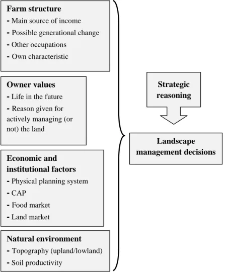
Figure 2.1 Analytical framework for studying owners' land management
decisions. Inspired by Madsen (2003).
Explaining decisions on landscape functions and structure needs an analysis of the values and practices of landowners, where decisions are understood as a result of the individual landowners 'strategic reasoning', that is landowners' 'weighting' of the different factors of influence: the context within which landowners make decisions ('room of manoeuvre') is thus a combination of contextual factors (van der Ploeg, 1994; Madsen, 2003).
In order to include a broad range of factors in the analytical framework (Figure 1), general studies of the relations between owners' values and their practices have been used (Green & Lemon, 1996; Wilson, 1997; O'Rourke, 1999; Primdahl & Kristensen, 2011; Rymond & Brown, 2011).
Other factors were included in the first draft of the framework, such as age, gender, education degree, but they did not emerge as relevant factors during the
Farm structure
- Main source of income
- Possible generational change
- Other occupations
- Own characteristic
Owner values
- Life in the future
- Reason given for actively managing (or not) the land
Natural environment - Topography (upland/lowland) - Soil productivity Landscape management decisions Strategic reasoning Economic and institutional factors
- Physical planning system
- CAP
- Food market
18
interviews, since it seemed evident that, within the heterogeneous group of interviewees involved in my investigation, there was no connection between those factors and practices. However, this could be related to the small number of people I interviewed.
Concretely, the individual factors that resulted to be relevant to landowners' land management decisions from the interviews have been placed under the headings of Figure 1, i.e. “Farm structure”, “Owner values”, “Economic and institutional factors”, “Natural environment”. In this way the contextual reading process of data resulted to be very straight and clear.
Final decisions within the decision-making processes with regard to landscape structures and functions usually is the culmination of a range of factors, often interrelated: hence, the relationship between values and practice is not a linear one-to-one relationship, and separate analysis of individual factors may be misleading to fully understand the causal relations shaping agricultural landscapes (Wilson, 1997; Madsen, 2003).
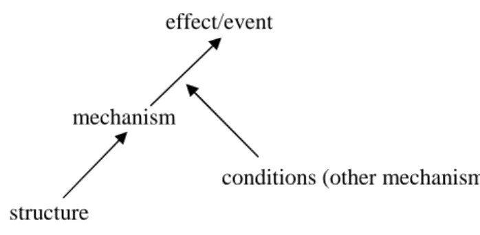
Figure 2.2 View of causation, by Andrew Sayer,2000.
Figure 2 may help to understand the relationships between motives, practices and landscape outcomes. It shows that the same mechanism can produce different outcomes (or that a different mechanism can produce the same outcomes) according to context and its spatio-temporal relations with other objects, having their own causal powers. More explicitly, values do not lead directly to a certain action, likewise different values may lead to the same landscape management decisions and, therefore, to similar landscape outcomes.
This would be the case, for instance, of the establishment of uncultivated elements for different purposes, such as for ecological restoration or environmental 'beautification' or for both purposes. It could be also the case of similar management practices in different farmlands/land properties when large tracts of countryside are managed by few or single contractors, or, to give another example, of building recovery for very different purposes such as housing or agritourism development, etc.. Such 'regularities' are usually approximate and limited in duration; regarding landscape studies and monitoring, they may become
structure
mechanism
conditions (other mechanisms) effect/event
19
less apparent or even vanish together with changes in land holding (Marsden & Munton, 1991).
I anticipate that at the methodological level, the findings of this research highlights the importance of analysing the complex of factors affecting the individual landowner.
In Chapter 3 I focused on the role of human agency, more precisely on the socio-economic context. I used the collected information through interviews on farm structure, owner's values, and economic factors, in order to make a typology of landowners explaining the different types of land management. Other source of evidences were mainly used for methods triangulation.
In Chapter 4 I focused on external-institutional factors, in particular the influence of the planning framework on owners' decision making process on landscape management. The analysis involved the consultation of documents such as Environmental Impact Assessment (EIA) and the Municipal Plans. Interviews were used to understand how landowners relate to, and are influenced by, such external conditions.
In Chapter 5 I used a more holistic approach involving both human and non-human agency (the natural environment) to understand owners' landscape decisions. Indeed the landscape can be also considered as an agency in itself (Ingold, 1993); more precisely, in the case study illustrated in Chapter 5, a hilly landscape in Pontedera represents a source of intrinsic values to a group of lifestyle rural landowners due to its cultural heritage and history, beautiful scenery and natural incompatibility with modern-mechanised agriculture, in opposition to its near lowland where the land represents unit of production and/or economic rent.
Overall, my research design is modelled after the iterative procedure that Vayada called the 'progressive contextualisation procedure', which involve focusing “on significant human activities or people-environment interactions and then explaining these interactions by placing them within progressively wider or denser contexts” (Vayda, 1983: 265). For instance, while socio-economic contextual factors proved to be useful to understand the management practices of different groups of owners (Chapter 3 and Chapter 4), the fact of considering few upland dwellers' turn to land as a phenomenological mode seemed to be the appropriate interpretation of the attitudes towards farming and the attachment to land of the small group of landowners in a sub-municipal scale (Chapter 5). In other words, the socio-economic reading does not represent the only possible interpretation of landscape management decisions, and the phenomenological
20
description of the lived experience of farming can be an alternative and complementary approach to the analytical socio-economic and institutional explanation based on structural relations.
2.2 Procedure
The present research was designed as a case study with emphasis on in-depth analysis rather than statistical generalisations. Thus, the aim was not to extrapolate from a representative sample (see also Chapter 3 and Chapter 5 of this thesis for more details).
The principle of methods triangulation was applied with the information gathered from a variety of sources including qualitative interviews with landowners, statistical data, direct observation, official documents, local published literature, press reviews, websites.
The use of interviews with key stakeholders is a long standing practice in environmental management and rural sociology studies, where interviews are used to document local attitudes. Interviews are employed in landscape studies as well, in order to investigate the relationships between landscape and people, as well as between landscape management and landscape changes (Primdahl, 1999; Egoz et al., 2001; Busck, 2002; Madsen & Adriansen, 2004; O'Rourke, 2005; Calvo-Iglesias et al., 2006; Qviström & Saltzman, 2007). The most important issues of interviewing included the informants selection, the sample size, the interview-questionnaire format and the use of other sources of evidences to support the interviewees' reports. Detailed information about the sampling techniques, the topics in focus and the analysis of the interviews are presented in Chapter 3, Chapter 4, Chapter 5, and are summarised in Table 1.
21
I used a semi-structured format, in order to obtain homogeneous interviews; however, given the inductive approach, openness and flexibility in the process were preferred. For instance, interviewees were encouraged to tell detailed stories of past and possible future change within their property, by using a guide-interview format and several open questions rather than just yes/no questions. The interviews were both retrospective and prospective in scope. A set of questions within the analytical framework was used to guide the interviews with landowners. The questionnaire I used for the interviews is in Appendix. Other sources of evidences were used, as told and fully explained in Chapter 3, Chapter 4 and Chapter 5.
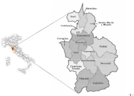
Figure 2.3 The case study area, represented by 15 Municipalities placed in
Valdera, Tuscany.
The investigation started in Autumn 2009 and finished in Autumn 2012. It took place in Valdera, a Tuscan area of 15 Municipalities close to Pisa. The choice of this area as a case study for my research is due to the following grounds:
• the landscape of the area is rather heterogeneous, comprising agricultural landscapes under urban pressure (both at the urban fringe and in the rural hinterland), traditional hilly landscapes and flat areas with mechanised-specialised agriculture;
• in 2007 the 15 Municipalities joined in a Union of Municipalities (Unione della Valdera) in order to undertake the inter-municipal agreement for services
22
delivery. Over the next years, these Municipalities are expected to give the Union the main responsibility for spatial planning (see Chapter 4).
Furthermore, I was involved in a project, funded by the Regione Tuscana, aimed at studying the Land Capability Classification of Valdera1. Although I did not use for my thesis the data collected for that study nor its results, the participation to local workshops and focus group helped me to gain familiarity with the place and the local stakeholders, therefore to better understand the context of the study area.
NOTES
1. For more information on the project see the site:
http://www.avanzi.unipi.it/ricerca/quadro_gen_ric/ricerche_concluse/capability_la nd/documenti_capability_land/capability_land_progetto.pdf
24
Chapter 3
Regulating and managing private farmland and public
space. Case studies from Valdera, Tuscany
3.1 Introduction
While approaching rural land management and planning, environmental conservation and farm diversification represent two relevant paradigms in a time of crisis of modern agriculture; a quick look at local landscape will show that the relationship between these paradigms, as well as between them and the territorial context(s), are not unproblematic. Over the last two decades, rural areas have been increasingly demanded for leisure and outdoor recreation, wildlife, landscape, and housing. While landowners develop their holdings according to their interests and interpretation of new constraints and new options (Van der Ploeg 1994), in policy circles, the increasing concerns on the preservation of rural landscapes have led to the introduction of environmental measures within the CAP, within planning systems and the European Landscape Convention. These interests, the multiple meanings and uses associated to land (consumption, production, conservation), and its hybrid nature (rural and urban) may cause environmental and institutional pressures on the agricultural landscape.
In this chapter I try to examine land system changes through the lens of local planning processes and landscape management decisions by drawing on three case studies; implications for public planning and regulation are discussed throughout the chapter. I use in-depth case studies of a research conducted in Valdera (Tuscany), which I have already introduced in Chapter 2.
In an Italian context – where landscape planning and policy are characterised by regulatory rather than strategic functions, a 'negotiative' rather than a 'deliberative' approach (Khakee & Barbanente, 2003), and the recognised lack of transparency (Transparency International, 2010) – a number of procedural compliances often emerge in management growth and physical planning fields. Hence, planning processes in the countryside need to be studied from different perspectives. The main notions and perspectives I use in this chapter are those of urban-rural division, land ownership, and landscape policies. Study findings may provide inputs to the ongoing debate on future planning measures in Tuscany.
25
3.2 Case study area and context
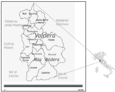
The study context is represented by fifteen Municipalities, under the Province of Pisa, located in a geographical area, called Valdera, crossed by the Era river, an Arno river's affluent. In 2007 the population of the area was 117.517 inhabitants distributed throughout a total surface of 624,17 km2 (187 inhabitant/km2).
The area is characterised by different characteristics. The diversity deals both with the socio-economic contexts and physical-environmental elements. For what concerns the first aspect, the area involve industrial and more urbanised municipalities, Pontedera, Ponsacco and Calcinaia in particular, with 27.808, 14.688 and 10.473 inhabitants respectively (2007). The typical rural municipalities of Valdera are Lajatico, Chianni, Terricciola, with 1387, 1536 and 4389 inhabitants respectively in 2007. These municipalities that have maintained a rural character are mainly located in hilly landscapes.
Figure 1: Valdera, the case study area
Agriculturally, the main crops are cereals and oleaginous crops, while vines and olives usually represent marginal percentage of the UAA, with the highest values in Terricciola where the UAA of vines is 13% of the municipal UAA, and in Buti where the UAA of olives is 40% of its UAA (ISTAT, 2000). The average farm size is 5,92 ha (ha), with the highest values in Peccioli and Lajatico (12,5 and 17,5 respectively), while the size usually ranges from less than 1 ha to more
26
than 100 ha in most of the municipalities. The last available statistical data at the municipal level are relative to 2000; more recent data at a provincial level are available and they display a decrease in number of small farms and an overall increase in farm size. Over the period 2000-2010 the number of farms decreased of 50,4% within the Province of Pisa area (39 Municipalities), shifting from 14.473 to 7.174; the UAA decreased of 11%, shifting from 108.611,44 to 96.718,65 (UAA). More explicitly, a great process of land amalgamation has led to the decline of small farms, and to the increase of average farm size from 7,5 ha to 13,48 ha. Although official statistical data of the last census 2010 are not available at the local scale, the fieldwork – by means of direct observation and interviews with landowners and local agricultural officers – proved this process is taking place within the Valdera area as well.
3.2.1 The planning context
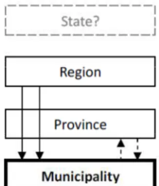
The planning system in Italy is decentralised and gives the municipality important responsibilities for spatial planning. Figure 1 shows, through the arrows, the power relations between the different levels – State, Region, Province, Municipality – , and, through the rectangular frames, their weight in the national spatial planning system.
Figure 2. Relationships between levels in the Italian planning system. Frames in
bold represent the main authority (inspired and adapted by the author from Busck et al. 2008).
Region has the task to make laws on spatial development, which are implemented by Municipality. Region, by means of Piano di Indirizzo Territoriale (PIT) identifies the objectives and strategies for territorial development at a general level; through Piano Territoriale di Coordinamento (PTC), Province supervises and monitors the implementation of the Regional law at the municipal level, acting as an intermediary between Region and Municipality1; a municipal plan – comprising the Urban Plan (Regolamento
27
Urbanistico, RU), and the Spatial Structural Plan (Piano Strutturale, PS) – charts public interests, overall strategies and the proposed use of land and water areas; RU and PS are complemented with detailed development plans (Piani Attuativi), which are binding for the public and private sector, offering legal rights to build or preserve an area (Legge regionale Toscana 3 gennaio 2005, n.1 “Norme per il governo del territorio”, http://www.rete.toscana.it/sett/pta/territorio/lr1_2005.pdf).
The definition of built-up (urban) and non-built (usually agricultural) areas is done locally by the municipal authority through detailed spatial designation and planning restriction tools (zonation system). Building activities outside built-up areas requires building permit of the Municipality. Indeed, the Municipality agenda addresses residential and industrial development within rather a flexible urban-rural-zonation system, through a 'base case' scenario approach (usually assuming growth). The 'predict and provide' way has been often criticised in the past in other countries, both in planning for housing and industrial development, since, it is argued, planning results are often forced to accommodate the projected numbers of houses/industrial development – which are often overestimated – in land allocation policies (Murdoch & Lowe, 2003).
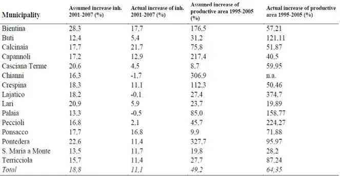
Table1: Data about the increase of inhabitants and productive areas assumed by
each Municipality and the actual ones (Source: Provincia di Pisa, 2008).
Table 1 shows the discrepancy between the increase of inhabitants assumed by the fifteen Municipalities of Valdera and the actual one in the period 2001-2007. For what concerns the inhabitants variation, it is worth noting that almost every Municipality assumed increase, also those with rural characteristics such as
Lajatico, Chianni, Palaia. consequences of this, it has
are built on the basis of the forecasts made by mentioned 'predict and
Figure 3: Soil consumption (%) for new housing in each
() 1995-2005 (Source: Provincia di Pisa, 2008).
Figure 3. Soil consumption (%) for production activities in each Municipality of
Valdera, 1995-2005 (Source: Provincia di Pisa, 2008). Recently, the introduction of the
intercomunale) within the regional law LR 1/2005 has been proposed in order to achieve a more efficient land allocation for new houses and industrial development, and for an effective integration of spatial and econ
In 2007 the 15 Municipalities joined in a Union of Municipalities ( Valdera) in order to undertake the inter
28
Lajatico, Chianni, Palaia. In order to understand the meaning and the consequences of this, it has to be considered that new houses and infrastructures are built on the basis of the forecasts made by each Municipality, according to the
predict and provide approach'.
Soil consumption (%) for new housing in each Municipality of Valdera 2005 (Source: Provincia di Pisa, 2008).
Soil consumption (%) for production activities in each Municipality of 2005 (Source: Provincia di Pisa, 2008).
Recently, the introduction of the inter-municipal plan (piano strutturale ) within the regional law LR 1/2005 has been proposed in order to achieve a more efficient land allocation for new houses and industrial development, and for an effective integration of spatial and econ
In 2007 the 15 Municipalities joined in a Union of Municipalities (
) in order to undertake the inter-municipal agreement for services In order to understand the meaning and the to be considered that new houses and infrastructures Municipality, according to the
Municipality of Valdera
Soil consumption (%) for production activities in each Municipality of
piano strutturale ) within the regional law LR 1/2005 has been proposed in order to achieve a more efficient land allocation for new houses and industrial development, and for an effective integration of spatial and economic planning2. In 2007 the 15 Municipalities joined in a Union of Municipalities (Unione della municipal agreement for services
29
delivery. Over the next years, these Municipalities are expected to give the Union the main responsibility for spatial planning.
The environmental restriction (Vincolo paesaggistico) is another instrument acting in parallel to the planning restriction tool. It was introduced by the Decreto Galasso D.L. 431/85, which gives the Ministry of cultural heritage and activities3 the task to design areas subjected to environmental restrictions and to control their preservation status by means of local institutions: When a specific landscape become targets for preservation strategies, policies and actions are promoted by cultural heritage and nature protection agencies4. with the aim to safeguard specific spaces from the different contemporary processes that go on elsewhere. This results in a reification of landscape values and a delineation of fixed areas to be "properly" managed to maintain certain esthetical and biological values. Concretely, the vincolo paesaggistico prescribes land-use restrictions and management obligations (beyond general legislation); areas under conservation usually remain in private ownership and the affected owners don't receive any payments to compensate for the loss of some land rights.
The mechanism does not forbid, of course, surrounding areas to develop in other directions. As it will emerge by the case studies here presented, there is rather a clear separation between physical planning and environmental conservation fields. Some weakness of this system are discussed at the end of the text.
3.3 Case studies
The case studies described below are selected in order to explore diverse configurations of tensions between different actors, sectors and interests. In order to preserve the anonymity of respondents and to facilitate more comprehensive description and analysis of the research issues under investigation, the locations and interviewees of the chosen case studies are not identified through their real names.
3.3.1 Case study 1 – Stressing outdoor recreation in a periurban context
This case study deals with the development of a car track project within a farmland in a periurban area. The project involves the conversion of about 60 ha of land from agricultural to recreational use, for the development of a racetrack and accommodation facilities. The owner of the farmland, covering a surface of around 100 hectares, is a long established full time farmer; the land cover of the
30
project area, before its starting, was mostly arable land, woodland patches and small biotopes.
The project also entails the conversion of barn buildings, the construction of new buildings and a parking area.
Permission to develop the project within the farmland was made in the context of an Environmental Impact Assessment, the EIA5, undertaken by consultants which was finished in 2011. Therefore the Variante Strutturale, which allows buildings and land use changes, was approved by the municipality. The EIA materials are available for public consultation through the Municipal authority. It is not the purpose here to provide a detailed analysis of the EIA and express reservations about the scientific credibility of specific conclusions. According to the scope of the chapter, I try to sum up the EIA statements that were carried out prior to the project's development and some aspects of the related decision-making process.
During the interview with the farmer in question, a number of issues related to the decision motives, the past, current and likely future changes within his property emerged. In particular, after the project's development, only part of the woodland patches and small biotopes will be kept, while the farm production within the property will be removed. The following excerpts from the interview with the landowner provide rather explicit explanations: “There is no way to get any return on industrial agriculture... Go back and adjust the farmland business and structure according to the emerging, promising niche market is too late. Now I want this area to represent an important open space area and the green lung of the city, where people come to walk and have fun... And I feel happy the big project has been approved. At last we have got it!”
The farmer has opted for what he considers a more immediate and certain economic strategy, thus eroding the property's agricultural base; moreover, while he claims to provide “open space... where people can walk... ”, in the project plan there is no proposal which does design the area to be open to the public for informal recreation either.
The EIA documentary material shows that the project was accepted by the Municipality with only minor restrictions, in particular limitations on the remodelling of the soils and landscape. No detailed information about the status of the area before the project are present in the documentary material, therefore it seems unclear where the “benefits for the local landscape” could arise from the project. For instance, at a general level the Environmental Assessment suggests that the project will not impact on biodiversity; we are not told how the transition
31
from farmed arable land of unknown/untold biodiversity status to a racetrack area would not impact the biodiversity and the landscape structure. Overall, the assessment documents lack of many of the well known indicators of state, impact, response, drivers and pressure, which often are calculated and used by consultants/experts within the EIA procedure. The documents don't say anything whether the assessment procedure have considered and explicitly addressed, at the planning stage, social and economic factors: residents' point of view on the project and its impacts, the economic viability and an accurate estimation of demand for such kind of facilities. There is no clear requirement to check that possible benefits or negative impacts that could achieved/avoided in a post-development stage.
During my fieldwork in the area, I asked local farmers about their views on development plans at a general level, and how in their opinion they may affect the neighbouring properties. It was possible to identify two distinct groups of farmers: those who consider land development as something they themselves need to do to survive economically; and those who complain about the environmental impacts and the increase of land prices due to land development, which “makes the young's entrance to agriculture even more difficult”. Interestingly, a few farmers, albeit not asked, expressed opposition to the project in question: “The project has not been conceived to save the farm nor to provide the open space for everyone's benefit, as they [the owner and the Municipality officers] claim”, “This is speculation. A few people will benefit from it, I feel the local community and us farmers will not”, “The environmental impact is going to be great”. Furthermore, a group of stakeholders, represented by neighbouring farmers and local residents, have joined in a group opposing the project (Comitato di La Rosa): their arguments against the car track mostly deal with the environmental impacts (noise, farmland loss, pollution).
3.3.2 Case study 2
This case is about the tensions between farmers' caretaker task for the land, the politics of housing at a local level and environmental designations. The setting is a rural hilly municipality situated in the context of the Colline Pisane wine route6.
The interviewed farmer is a professional full-time farmer with a rural background, personally engaged in farming and landscape management. He owns 70 ha of land partially located in terrace hill land with olives and vines within an area subjected to environmental restrictions. During the interviews, he shows concerns about reduced income from farming as a consequence of food market
32
competition. Nevertheless, he rejects the idea of abandon farming. First and foremost, this group of landowners see themselves as food producers, then, as land managers.
During the interview, he reported how he experiences the place his farmland is located in, the constraints and the institutional setting: “The environmental restrictions impose us to keep and manage these terraces, everything at our expenses. Pruning, grapes and olives gathering, and every landscape management operations have to be done by hand because of the terraces and the restrictions. This makes our products very good and different from industrial products, however this also increases the costs of production... Well, I don't ask for incentives, because managing the land is my work... and this landscape is beautiful. Well, developers do what they like, though. Even here, close to these terraces. Look there at the foot of the hill, new houses have been built few years ago. Moreover most of them are still empty [unsold]. You know, actually because of the restrictions nothing could be built here. But restrictions can easily be bypassed!”.
And he followed: I really feel that working the land is something important here. If we abandoned the activity [farming], that houses you see down there, which have been built with a wrong urbanisation, would be flooded whenever it rains. Everything here is a great contradiction”.
3.3.3. Case study 3
Urbanisation in periurban areas represents a traditional threat of farms, especially when 'public interest' is identified with ideas of industrial and urban development. In western society, expropriation on grounds of public interest represents relatively radical type of intervention, and it is followed by economic compensation to the landowner in question.
In this section I will provide one example from interview with a full time farmer who owned 100 ha of arable land in a periurban municipality close to Pisa. In 2005 the local municipal authority bought 60 ha of his property to use it for industrial development “in the near future”. The industrial development project, which seems will cause the agricultural erosion of the area, has not yet achieved after seven years.
Data provided by the Province of Pisa (2008) display urban and industrial development represent a master development model within the area. A number of projects are facing viability problems, largely due to the fact that development
33
capacities have been over-estimated at the planning stage. Indeed the 'growth scenario' for the period 1995-2005 provided by the Municipality in question assumed an increase in productive land for industrial development which was three times as much as the actual one was (Province of Pisa, 2008).
The farmer in question still grows the farmland (the expropriated land as well). During the interview he said:
“It is difficult to plan any sort of farm investments here. […] The planning for the next season needs to be done a year ahead... but the local authority might unexpectedly start the construction works. Then I sow my fields at my own risk. [...] I do manage the land, I really feel this is my work. I clean the ditches and drainage channels, we would have flood problems... I do it because I am farmer, but I wonder myself: whose is this land? I don't feel it is still mine, you know”. While answering my interview questions, he showed me a recent article in a local newspaper to corroborate his arguments. The article reported: “Owners who will not clean the ditches within their property will be fined by local authorities” (Il Tirreno, October 2010). The farmer commented: “Yes, but it's amazing I would be fined if I cleaned the channels and waterways in abandoned field that nobody does care for. I find there are great contradictions... do local bureaucrats really further the public interest”?
He followed:
“The law and bureaucracy have been regulating everything and everywhere and the result is the land is increasingly abandoned and neglected or abandoned. [...] This land [his farmland] is something in-between. Well, abandoned farmland is neither wilderness nor cultivated. It is not easy to define abandoned farmland. There are large tracts of countryside which have not being farmed for several years, while the owner is waiting for the land price to set to soar... Or there is some land, which was bought by the Municipality for development, which is farmed and tilled only occasionally. Should these areas be considered abandoned farmland or not?”.
Discussion
Notes
1. When farmers apply, for instance, for planning permissions in order to be allowed to change the use of rural buildings, the Province is required to