ABSTRACT
Il rapporto IPCC del 2018 rappresenta lo stato attuale delle conoscenze sui cambia-menti climatici e sui loro potenziali impatti ambientali e socioeconomici. Una delle con-seguenze più dirette di tali cambiamenti è rappresentata dall’innalzamento del livello dei mari, tematica sulla quale si sofferma il contributo, evidenziando come, ad oggi, non esista un recepimento e una declinazione soddisfacente, nel livello di pianificazio-ne locale, degli indirizzi contenuti pianificazio-negli strumenti settoriali preposti alla gestiopianificazio-ne del fenomeno. Il contributo, a partire dai risultati di uno studio dell’ENEA, approfondisce il contesto territoriale del Mediterraneo, nello specifico quello italiano, con l’obiettivo di far emergere alcuni riferimenti metodologici ed operativi per l’elaborazione di possibili strategie di trasformazione dei contesti urbani interessati dal fenomeno di rischio. The IPCC 2018 report represents the current state of knowledge on climate change and its potential environmental and socio-economic impacts. One of the most direct consequences of these changes is represented by the raising of the sea-level, the topic on which the contribution lingers, highlighting how, to date, there is no declina-tion, at the local planning level, of the content addresses in the sectoral tools respon-sible for managing the phenomenon. The contribution, starting from the results of a recent ENEA research, explores the territorial context of the Mediterranean, specifi-cally the Italian area, to bring out some methodological and operational suggestions for the elaboration of some possible strategies for transforming urban contexts affected by flooding.
KEYWORDS
cambiamenti climatici, innalzamento livello del mare, strategie di adattamento, resilien-za urbana, funzionalità ecologica
climate change, sea-level rise, adaptation strategies, urban resilience, ecological func-tionality
Carmela Mariano, Marsia Marino
INONDAZIONI COSTIERE NEL
MEDITERRANEO
Strategie di trasformazione per città resilienti
COASTAL FLOODS IN THE
MEDITERRANEAN
Trasformation strategies for resilient cities
Carmela Mariano is an Associate Professor in Urban Planning at the Department of Pianificazione,
Design e Tecnologia dell’Architettura (PDTA), Sapienza Università di Roma (Italy). She is the Presi-dent of the CdLm in ‘Architettura – Rigenerazione Urbana’, and a Member of the Academic Board of the PhD Program ‘Pianificazione, Design e Tecnologia dell’Architettura’ – PDTA Department. Mob. +39 346/11.13.542 | E-mail: [email protected]
Marsia Marino, Architect, is a PhD student in ‘Pianificazione, Design e Tecnologia dell’Architettura’
at the PDTA Department, Sapienza Università di Roma (Italy). She is carrying out research on the management of coastal cities subjected to flooding due to sea-level rise. Mob. +39 388/44.38.378 E-mail: [email protected]
Le profonde trasformazioni fisiche e sociali che hanno interessato la città contemporanea negli ultimi decenni, il progressivo aumento demografico, i cambiamenti climatici, gli squili-bri territoriali e il depauperamento delle risorse ecologiche ed energetiche, hanno determina-to una profonda riflessione delle discipline che operano sui territori, con l’obiettivo di delinea-re strategie e tattiche in grado di indirizzadelinea-re e progettare realtà sempre più complesse e di governare una metamorfosi resiliente (Gunder-son and Holling, 2002) della città contempora-nea (Gasparrini, 2017). Un cambio di paradig-ma che si colloca nel dibattito di quello che è stato definito il passaggio dall’era dell’Antro-pocene (Crutzen, 2005) al cosiddetto Neo-An-tropocene (Carta, 2017) in cui, acquisita la consapevolezza dell’impatto antropico sul cli-ma e l’ambiente, si cerca di utilizzare le risorse territoriali in maniera più creativa e intelligente, per assicurare uno sviluppo sostenibile per le generazioni presenti e future.
In questo contesto di riferimento, le temati-che relative alle polititemati-che di mitigazione e adat-tamento delle aree urbane agli effetti territoriali prodotti dal cambiamento climatico (UNISDR, 2012; UNFCCC, 2015) acquisiscono una note-vole rilevanza e richiedono, rispetto al passato, la messa a punto di una strategia integrata di intervento sui territori urbani e metropolitani (European Commission, 2007) e di nuovi riferi-menti metodologici e operativi per una trasfor-mazione sostenibile del territorio, come auspi-cato anche dagli obiettivi della Agenda globale per lo sviluppo sostenibile 2030 (UN, 2017, pp. 4, 5) che invita a «rendere le città e gli insedia-menti umani inclusivi, sicuri, duraturi e sosteni-bili» (Goal 11) e «adottare misure urgenti per combattere i cambiamenti climatici e le sue conseguenze» (Goal 13).
Il rapporto dell’Intergovernmental Panel on Climate Change (IPCC, 2018) rappresenta lo stato attuale delle conoscenze sui cambiamenti climatici e sui loro potenziali impatti ambientali e socioeconomici, tematica sempre più centrale nel dibattito internazionale poiché condiziona da un lato la salvaguardia di territori, paesaggi e contesti urbani fragili, dall’altro usi, prestazioni ed efficienza di manufatti architettonici e oggetti di uso quotidiano. Una delle conseguenze più dirette dei cambiamenti climatici in atto è, sen-za dubbio, rappresentata dal costante e repen-tino innalzamento del livello dei mari, tematica sulla quale il presente lavoro intende soffermar-si, con l’obiettivo di offrire un contributo scienti-fico che favorisca, da un lato, il progresso della conoscenza sulle misure di adattamento dei territori costieri interessati da fenomeni di inon-dazioni e, dall’altro, l’individuazione di azioni di riconnessione e di riconfigurazione delle com-ponenti morfologiche e ambientali (Musco and Zanchini, 2014; Mariano and Marino, 2019) in grado di rispondere alla fragilità e vulnerabilità dei territori contemporanei.
Il contributo, che si colloca all’interno delle attività di ricerca condotte nell’ambito del Dot-torato di Pianificazione, Design e Tecnologia dell’Architettura, Dipartimento PDTA, Sapienza Università di Roma, con il progetto ‘Cambia-menti climatici e nuove geografie urbane: Stra-tegie di adattamento territoriale per le città
co-stiere soggette a fenomeni di inondazione. Una matrice italiana’1, indaga il concetto di sviluppo
resiliente dei territori costieri attraverso la con-cettualizzazione di possibili strategie di trasfor-mazione dei contesti urbani interessati dal fe-nomeno di rischio, differenziate in relazione alla specificità dei contesti territoriali e volte, da un lato, alla prevenzione del rischio e alla minimiz-zazione degli impatti causati dai cambiamenti ambientali, antropici e sociali e, dall’altro, foca-lizzate sul carattere dinamico delle metodolo-gie operative, ideative e compositive/proget-tuali, in cui tutti gli elementi dell’ambiente co-struito si adattano ai nuovi equilibri con effi-cienza ed elevati livelli prestazionali.
Il campo di indagine è, dunque, quello delle inondazioni costiere in ambiente urbano e il contesto territoriale di riferimento è quello del Mediterraneo. Obiettivo di questa fase della ri-cerca, tuttora in corso, è quello di procedere, a partire dai risultati di un recente studio condot-to dall’ENEA (Ancondot-tonioli et alii, 2017), avente ad oggetto l’approfondimento degli impatti fisici e geologici prodotti dall’innalzamento del livello del mare su 4 aree costiere (la pianura costiera dell’Adriatico settentrionale, Taranto, Cagliari e Oristano) in un orizzonte temporale al 2100, e una verifica degli esiti della sovrapposizione delle mappe del rischio elaborate con gli stru-menti urbanistici vigenti nelle aree esaminate. L’obiettivo è quello di declinare, negli strumenti di pianificazione urbanistica, le indicazioni e le prescrizioni degli strumenti settoriali, che
atten-gono al campo delle misure di mitigazione de-gli impatti, individuando alcuni riferimenti meto-dologici e operativi a supporto delle Pubbliche Amministrazioni per l’elaborazione di strategie di trasformazione sostenibile dei contesti urba-ni interessati dal fenomeno di rischio.
Questo significa, in primo luogo, individua-re le modalità per assumeindividua-re, al livello della pia-nificazione urbanistica locale, le prescrizioni dei PAI (Piano di Assetto Idrogeologico) e dei PGRA (Piani di Gestione del Rischio Alluvioni). Il primo è uno strumento conoscitivo, normati-vo e tecnico-operatinormati-vo di livello regionale, me-diante il quale l’Autorità dei Bacini Regionali in-dividua, nell’ambito di competenza, le aree da sottoporre a tutela per la prevenzione del ri-schio, sia mediante la pianificazione e pro-grammazione di interventi di difesa, sia me-diante l’emanazione di norme d’uso del territo-rio ed ha valore di Piano Territoriale di Settore; il secondo, introdotto con il DLgs 3 aprile 2006, n. 152 – Norme in materia ambientale, individua e definisce gli scenari di allagabilità e di rischio idraulico su differenti tempi di ritorno, coinvolgendo, dunque, competenze disciplina-ri in tema di difesa e salvaguardia del terdisciplina-ritodisciplina-rio (pianificazione territoriale, opere idrauliche e in-terventi strutturali, programmi di manutenzioni dei corsi d’acqua), sia di protezione civile e si-curezza urbana (monitoraggio, presidio, ge-stione evento e post evento), come stabilito dal DLgs 49/2010 di recepimento della Direttiva Alluvioni (Distretto Alpi Orientali, 2017). Mariano C., Marino M. | AGATHÓN | n. 06 | 2019 | pp. 104-113
Nei paragrafi successivi, il contributo ap-profondisce il riferimento allo studio elaborato dall’ENEA e il caso dell’area costiera dell’A-driatico settentrionale, a partire dall’analisi di uno degli strumenti settoriali vigenti in uno dei territori più vulnerabili al rischio inondazione da innalzamento del livello del mare dell’area mediterranea.
Innalzamento del livello del mare nel Medi-terraneo. Il contesto italiano | Lo studio
ENEA, cui si è fatto sin ora riferimento, è la ri-cerca dal titolo ‘Sea-level rise and potential drowning of the italian coastal plains: Flooding risk scenarios for 2100’, pubblicata da Anto-nioli et alii (2017) sul Quaternary Science Re-views e costituisce un punto di partenza im-portante per la ricerca che le autrici stanno conducendo. In Europa circa 86 milioni di per-sone (il 19% della popolazione) vivono entro i 10 Km dalla costa (Antonioli et alii, 2017) e nell’area mediterranea la percentuale sale al 75%; l’Italia, con i suoi 7.500 Km di costa, re-gistra valori di concentrazione demografica che si aggirano intorno al 70%. È importante considerare come la rapida urbanizzazione de-gli anni ‘60 del XX secolo abbia contribuito a
uno sviluppo, in molti casi non pianificato, degli insediamenti costieri che sono oggi esposti al serio rischio di inondazione (Sterr, Klein and Reese, 2003). Ad aggravare la situazione con-tribuisce anche la presenza, in questi luoghi, di importanti siti naturalistici e archeologici che implica la necessità, sempre più urgente, di mettere a punto un modello di trasformazione urbana resiliente di tali territori, che coniughi misure di mitigazione e di adattamento.
In molte aree costiere del Mediterraneo si stanno registrando sempre più frequenti feno-meni di inondazione. Le aree a maggior rischio sono quelle turche (Anzidei et alii, 2011), l’area costiera nord adriatica (Antonioli et alii, 2007; Lambeck et alii, 2011), le isole Eoliche (Anzidei et alii, 2016), le coste dell’Italia centrale (Aucelli et alii, 2016) e il Marocco orientale (Snoussi, Ouchani and Niazi, 2008). Le previsioni globali al 2100 variano tra 530 e 970 mm secondo l’IPCC (2013) e tra 500 e 1.400 mm secondo Rahmstorf (2007). Un ulteriore dato allarmante è che anche se l’emissione di gas serra dimi-nuirà, si prevede comunque un innalzamento del livello del mare tra 280 e 610 mm per lo stesso periodo. In questo scenario, oltre mez-zo metro di innalzamento del livello del mare, si
registrerà un impatto importante lungo le co-ste, causando un’erosione diffusa. Questo im-patto morfo-dinamico includerà probabilmente la migrazione interna dell’erosione costiera, au-mentando in modo significativo il rischio di allu-vioni, soprattutto in caso di eventi estremi.
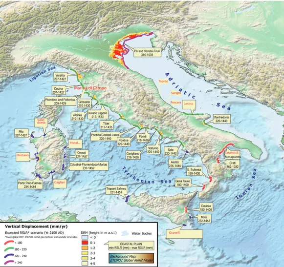
Per quanto riguarda l’Italia, lo studio di Lambeck et alii (2011) ha elaborato una proie-zione dell’innalzamento del livello del mare al 2100 sulla base del report IPCC 2007 e Rahm-storf (2007), i cui risultati mostrano che, assu-mendo un innalzamento minimo di 180 mm e uno massimo di 1.400 mm, 33 aree costiere italiane saranno inondate entro la data della proiezione (Fig. 1). Per la regione italiana inda-gata (Nord Adriatico, Golfo di Taranto e Sarde-gna), si ipotizza, al 2100, un innalzamento del livello marino di 530-970 mm (IPCC, 2013 – RCP 8.5) e 1.400 mm (Rahmstorf, 2007).
L’ENEA, a partire da questi dati, ha elabo-rato una metodologia per verificare l’effetto dell’innalzamento previsto con l’obiettivo di re-digere delle mappe relative agli scenari di inon-dazione di 4 aree oggetto di approfondimento, tramite un approccio multidisciplinare che, ol-tre a tener conto delle stime sull’innalzamento del livello del mare, prende in considerazione la
morfologia e la topografia terrestre. L’approc-cio metodologico utilizzato consiste nel consi-derare le diverse componenti dell’innalzamento del livello del mare: 1) le proiezioni IPCC-AR5 (scenari RCP-8.5) o Rahmstorf 2007; 2) i movi-menti verticali terrestri a lungo termine dei dati geologici; 3) il movimento glacio-idro-isostatico (GIA), per poi combinare i dati eustatici, isosta-tici e tettonici previsti per il 2100, in modo tale da ottenere i limiti minimi e massimi del livello del mare previsto per le regioni investigate e l’estensione interna delle possibili inondazioni. Questo studio ha portato all’elaborazione di un modello 3D ad alta risoluzione (DTM modello digitale del terreno) dell’area costiera, grazie al quale sono state redatte alcune mappe che in-dividuano le aree a rischio inondazione.2
Questo metodo, elaborato dal team ENEA per la costa italiana, può essere applicato in tutto il mondo in altre aree costiere interessate dal fenomeno. Questa breve digressione tecni-ca è funzionale a fornire un quadro conoscitivo della tematica oggetto di approfondimento, dal quale emerge chiaramente come l’aumento degli eventi climatici estremi, come le alluvioni e l’innalzamento del livello del mare, siano strettamente interconnessi, e come questi due
fattori, associati, abbiano un impatto ancora più drammatico in termini di inondazioni costie-re. Argomento confermato dal dott. Gianmaria Sannino, Responsabile del Laboratorio di Mo-dellistica Climatica e Impatti dell’ENEA, in un’intervista del 31 Luglio 2019. Semplificando molto il concetto, l’innalzamento del livello del mare crea una ‘base di appoggio’ per l’evento estremo più alta, determinando, di conseguen-za, effetti notevolmente più impattanti, in termi-ni di inondazione, sul tessuto urbano costiero. Tale considerazione assume, per la temati-ca oggetto del presente studio, una notevole rilevanza, in quanto consente di mettere in rela-zione i contenuti di alcuni strumenti settoriali, cui si è fatto sin ora riferimento (PAI e PGRA), che trattano esplicitamente i fenomeni alluvio-nali, con l’innalzamento del livello del mare, evento, di per sé, ancora poco considerato negli strumenti preposti alla gestione delle dina-miche di trasformazione territoriale. A tale pro-posito, nel paragrafo successivo, viene propo-sta una breve disamina sul PGRA come possi-bile supporto alla individuazione di strategie di trasformazione urbana.
Il PGRA come supporto per l’elaborazione
di strategie di adattamento urbano | Alla
lu-ce di quanto fin ora espresso, è importante sottolineare come la connessione tra sea-level rise e alluvioni sia ribadita anche dalla Comu-nità Europea, nella Direttiva Acque del Parla-mento Europeo e del Consiglio (Direttiva 2000/ 60/CE) prima e nella Direttiva Alluvioni del Par-lamento Europeo e del Consiglio (Direttiva 2007/ 60/CE) poi3, dove vengono considerate, oltre
ai bacini fluviali, anche le aree costiere. Ai sensi della Direttiva, tutti gli Stati membri devono do-tarsi di Piani di Assetto Idrogeologico (PAI) e Piani di Gestione del Rischio di Alluvioni (PGRA), due strumenti di pianificazione settoriale con-cettualmente molto simili, strutturati però su di-versi presupposti tecnico-amministrativi e con differenti finalità.
I PAI sono stati autonomamente predispo-sti dalle Autorità di bacino regionali, interregio-nali e naziointerregio-nali4sulla necessità di
perimetrazio-ne delle aree interessate da rischio idrogeolo-gico su tutto il territorio nazionale e sono stati concepiti con finalità principalmente riferite al governo del territorio, di conseguenza costitui-scono un riferimento fondamentale per la pia-nificazione urbanistica. I PGRA sono a scala distrettuale, cioè sotto il coordinamento di un
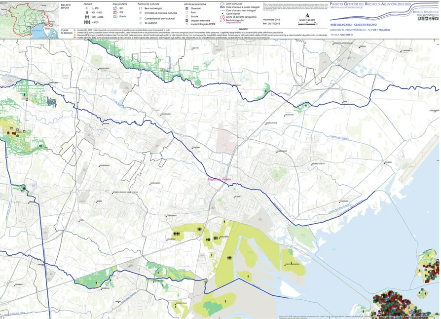
Fig. 3 | PGRA Eastern Alps District: map excerpt (quadrant O 08) with indication of water height, return time 100 years.
unico soggetto e con la convergenza delle Amministrazioni regionali e delle Province auto-nome presenti nel Distretto ed essendo piani per la gestione del rischio delle alluvioni, hanno la finalità di governo dei possibili eventi alluvio-nali, direttamente direzionati, quindi, all’azione della protezione civile.
Pertanto, i temi trattati dai due piani sono sicuramente correlati, ma i primi guardano a possibili modalità di trasformazione ed evolu-zione urbanistica del territorio, i secondi alla mitigazione degli effetti dell’evento calamitoso. Tali strumenti rappresentano, ad oggi, gli stru-menti più aggiornati per la tematica in esame, pur tuttavia non considerando direttamente il fenomeno del sea-level rise così come espres-so dallo studio ENEA e dunque presentano, a parere delle autrici, previsioni che si potrebbero definire ottimistiche. Sarebbe auspicabile, per-tanto, un’implementazione di tali strumenti che tenesse conto delle inondazioni così come evi-denziate nelle mappe del rischio elaborate da ENEA, direttamente focalizzate sull’impatto dell’inondazione costiera.
In questo paragrafo verrà analizzato il PGRA Distretto Alpi Orientali, in quanto, a pa-rere delle autrici, rappresenta uno strumento
con grandi potenzialità, non solo in termini miti-gativi e di gestione post evento, ma anche co-me punto di partenza per l’elaborazione di strategie di adattamento a scala locale. Verrà pertanto proposta un’analisi delle mappe del rischio pubblicate nel PGRA Distretto Alpi Orientali relativamente all’area oggetto di stu-dio, ovvero quella costiera dell’Adriatico set-tentrionale, più specificatamente quella della laguna Veneta, che rientra da una parte nel PAI del Bacino Scolante nella Laguna Veneta, dall’altra nel perimetro del PGRA Distretto Alpi Orientali. Le mappe del rischio presentate so-no lette alla luce di un loro possibile utilizzo al fine di elaborare strategie di adattamento urba-no per le aree interessate dal feurba-nomeurba-no.
Per tornare alla tematica di base alla luce della quale questo contributo prende forma, ovvero le strategie di resilienza tra mitigazione e adattività, nella presentazione del PRGA si parla chiaramente di obiettivo di ‘mitigazione del rischio’, auspicato coinvolgendo ai vari li-velli amministrativi, le competenze proprie sia della Difesa del Suolo (pianificazione territoria-le, opere idrauliche e interventi strutturali, pro-grammi di manutenzioni dei corsi d’acqua), sia della Protezione Civile (monitoraggio, presidio,
gestione evento e post evento), come stabilito dal DLgs 49/2010 di recepimento della Diretti-va Alluvioni. Il piano comprende un ampio spettro di azioni che va dalla programmazione di eventuali azioni di mitigazione, tipico della pianificazione di bacino fino alla gestione del-l’evento alluvionale; attività propria della Prote-zione Civile. I dati pubblicati, nella forma di mappe del rischio, non hanno, ad oggi, un ri-svolto per l’elaborazione di strategie di adatta-mento urbano, ma solo ai fini della mitigazione del rischio, pur potendo rappresentare, a pa-rere delle autrici, un valido strumento di sup-porto in tal senso.
Rispetto a ciò, le autrici propongono una lettura di questo strumento settoriale che vada oltre il suo attuale fine organizzativo di un’effica-cie gestione post evento e prevenzione in ter-mini di allertamento della Protezione Civile. La proposta, è quella di riflettere su un possibile impiego dei dati del PGRA, opportunamente in-tegrati con quelli evidenziati da ENEA, presen-tati nel primo paragrafo, per l’elaborazione di strategie di trasformazione urbana a livello loca-le in presenza di inondazioni costiere. Nell’am-bito dell’attività di ricerca che le autrici stanno conducendo, si è proceduto a una
lizzazione preliminare di tre macro-strategie di trasformazione urbana in presenza del fenome-no in esame: Difesa, Adattamento e Ricolloca-zione; per le quali la sopracitata sinergia tra dati del PGRA e risultati ENEA rappresenterebbe un supporto preliminare imprescindibile.5
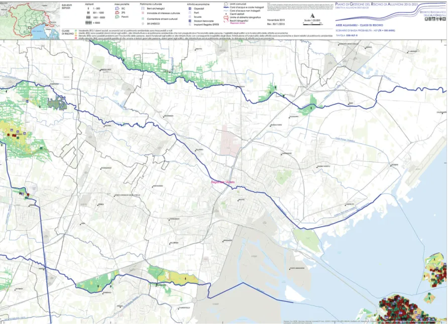
Nelle immagini viene proposto uno stralcio di mappa relativa all’inondazione su tre diffe-renti tempi di ritorno (30, 100, 200 anni) della laguna veneta al fine di inquadrare il fenomeno per l’area territoriale specifica. Le mappe forni-scono dati importanti sia sull’altezza idrica (Figg. 2-4), che sulle classi di rischio (Figg. 5-7), informazioni, soprattutto queste ultime, poten-zialmente preziose per la pianificazione futura delle aree interessate. In pratica vengono messe in relazione le diverse classi di rischio con gli elementi esposti. Per classi di rischio si intende: a) Moderato (R1): i danni sociali, eco-nomici ed al patrimonio ambientale sono tra-scurabili o nulli; b) Medio (R2): sono possibili danni minori agli edifici, alle infrastrutture e al patrimonio ambientale che non pregiudicano l’incolumità delle persone, l’agibilità degli edifici e la funzionalità delle attività economiche; c) Elevato (R3): sono possibili problemi per l’inco-lumità delle persone, danni funzionali agli edifici
e alle infrastrutture con conseguente inagibilità degli stessi, l’interruzione di funzionalità delle attività socio-economiche e danni relativi al patrimonio ambientale; d) Molto elevato (R4): sono possibili perdita di vite umane e lesioni gravi alle persone, danni gravi agli edifici, alle infrastrutture ed al patrimonio ambientale, la distruzione di attività socio-economiche. Per elementi esposti: 1) Abitanti; 2) Aree protette; 3) Patrimonio culturale; 4) Attività economiche.
Conclusioni | Appare evidente come
informa-zioni relative al numero di persone potenzial-mente coinvolte da un fenomeno di inondazio-ne, nonché delle attività economiche e del pa-trimonio culturale, rappresentino uno strumen-to di fondamentale importanza per lo sviluppo di strategie di adattamento urbano, che riesca-no a tenere in considerazione e prevedere le implicazioni culturali e socio-economiche che da essa ne deriverebbero. Quanto sin ora e-spresso, evidenzia chiaramente la necessità di un approccio transdisciplinare al tema in esa-me, che sia in grado di integrare tanto risultati afferenti a settori disciplinari differenti, tanto strumenti di pianificazione a diversi gradi di livel-lo in modo tale da favorire da una parte mobilità
nelle scale d’intervento (strutturale e di proces-so), dall’altra negli ambiti d’azione (economico, ambientale, sociale). L’obiettivo del lavoro pre-sentato, che rappresenta una ricerca in corso di elaborazione e, pertanto, come già in prece-denza esplicitato, con molti temi aperti, è quello di proporre alcune suggestioni su possibili ag-giornamenti degli strumenti preposti al governo del territorio con dati scientifici provenienti da settori differenti rispetto a quelli direttamente af-ferenti alla disciplina urbanistica, attraverso un approccio integrato alla complessità urbana, ma anche incentivare un approfondimento di scala rispetto al tema dell’adattamento del terri-torio agli effetti del cambiamento climatico.
The deep physical and social transformations recorded during the recent decades in the contemporary city, the progressive demo-graphic increase, climate changes, territorial imbalances and the depletion of ecological and energy resources, have determined a deep re-flection from the side of the disciplines that op-erate on the territories, with the goal of outlin-ing strategies and tactics capable of directoutlin-ing
Fig. 5 | PGRA District of Eastern Bees: map excerpt (quadrant O 08) with indication of risk classes, return time 30 years.
and sustainable (Goal 11) and underline the ur-gent to take measures to fight climate change and its consequences (Goal 13).
The Intergovernmental Panel on Climate Change report (IPCC, 2018) represents the current state of knowledge on climate change and their potential environmental and socio-economic impacts, an increasingly central is-sue in the international debate, since it affects the protection of territories, landscapes, and fragile urban contexts, on the one hand; us-ages, performance and efficiency of architec-tural artifacts and everyday objects on the oth-er hand. One of the most direct consequences of climate change in progress is, without any doubt, represented by the constant and sud-den rising of the sea level, the theme on which the present work intends to dwell, with the aim of offering a scientific contribution that favors the progress of knowledge on the adaptation measures of coastal areas affected by flooding phenomena and the identification of reconnec-tion acreconnec-tions and reconfigurareconnec-tion of morphologi-cal and environmental components (Musco and Zanchini, 2014; Mariano and Marino, 2019) able to respond to the fragility and vulnerability of contemporary territories.
The contribution, which is part of the re-search activities carried out in the framework of the PhD in Pianificazione, Design e Tecnologia dell Architettura, PDTA Department, Sapienza University of Rome, with the project ‘Cambia-menti climatici e nuove geografie urbane: Stra-tegie di adattamento territoriale per città costie-re soggette a fenomeni di inondazione. Una matrice italiana’1investigates the concept of
re-silient development of coastal territories through the conceptualization of possible transformation strategies of urban contexts affected by risk phenomenon. These strategies are differentiat-ed in relation to the specificity of the territorial contexts and are aimed, on the one hand, at preventing the risk and at minimizing the im-pacts caused by environmental, anthropic and social changes, on the other, are focused on the dynamic character of the operating, ideation-al and compositionideation-al methodologies, in which ideation-all the elements of the built environment adapt to new balances with efficiency and high-perfor-mance levels.
Therefore, the field of investigation is that of coastal flooding in the urban environment and the territorial context analyzed is that of the Mediterranean. The goal of this research phase, and designing increasingly complex realities
and governing a resilient metamorphosis (Gun-derson and Holling, 2002) of the contemporary city (Gasparrini, 2017). A paradigm shift that takes place in the debate on the transition from the Anthropocene Era (Crutzen, 2005) to the so-called Neo-Anthropocene (Carta, 2017) in which, having gained awareness of the an-thropic impact on the climate and the environ-ment, the human beings try to use land re-sources more creatively and intelligently, to en-sure sustainable development for present and future generations.
In this context of reference, the issues re-lated to mitigation and adaptation policies of urban areas to the effects produced by climate change (UNISDR, 2012; UNFCCC, 2015) ac-quire considerable relevance and reac-quire, with respect to the past, development of an inte-grated strategy of intervention on urban and metropolitan areas (European Commission, 2007) and new methodological and opera-tional references for a sustainable transforma-tion of the territory. This is also the goal of the Global Agenda for Sustainable Development 2030 (UN, 2017, pp. 4, 5) which calls for mak-ing cities and human settlements inclusive, safe
still in progress, is to proceed, starting from the results of a recent study conducted by ENEA (Antonioli et alii, 2017), to overlapping of risk maps drawn up by ENEA with the urban plan-ning instruments in force in the areas examined. The ENEA study above mentioned is about the physical and geological impacts produced by the sea level rise on 4 coastal areas (the coastal plain of the northern Adriatic, Taranto, Cagliari, and Oristano) in a time horizon to 2100. The hope is that thanks to this comparison will be possible to define, in the urban planning tools, the indications and prescriptions of the sectoral instruments analyzed in the paper, which relate to the field of mitigation measures, identifying some methodological and operational refer-ences to support the Public Administrations for the elaboration of sustainable transformation strategies of the urban contexts affected by the risk phenomenon.
This means, first of all, identifying the meth-ods for assuming, at the level of local urban planning, the prescriptions of the PAI (Hydro-geological Structure Plan) and the PGRA (Flood Risk Management Plans). The first is a cogni-tive, regulatory and technical-operational tool at the regional level and represent a Territorial
Sector Plan, through which the Regional Basin Authority identifies, within the sphere of its competence, the areas to be subjected to pro-tection for risk prevention, both through plan-ning of defence interventions, both through the issuing of land use regulations; the second, introduced with Italian Legislative Decree 3 April 2006, n. 152 – Environmental regulations, identifies and defines the scenarios of flooding and hydraulic risk on different return times, thus involving disciplinary competences in the field of defence and safeguard of the territory (territorial planning, hydraulic works and struc-tural interventions, programs of maintenance of watercourses), both for civil protection and urban security (monitoring, supervision, event and post-event management), as established by Italian Legislative Decree 49/2010 trans-posing the Floods Directive (Distretto Alpi Orientali, 2017).
In the following paragraphs, the contribu-tion deepens the ENEA study and the case of the coastal area of the northern Adriatic, start-ing from the analysis of one of the sectorial instruments in force in one of the most vulner-able territories to the flood risk from the raising of the sea level of the Mediterranean area.
Sea level rise in the Mediterranean. The Italian context | The ENEA study, to which
reference has been made so far, is the re-search entitled ‘Sea-level rise and potential drowning of the Italian coastal plains: Flooding risk scenarios for 2100’, published by Antonioli et alii (2017) on Quaternary Science Reviews and constitutes an important starting point for the research that the authors are conducting. In Europe, around 86 million people (19% of the population) live within 10 km of the coast (Antonioli et alii, 2017) and in the Mediter-ranean area the percentage rises to 75%; Italy, with its 7,500 km of coastline, has demo-graphic concentration values of around 70%. It is important to consider how the rapid urban-ization of the 60s of the 20th century has con-tributed to the development of coastal settle-ments, in many cases unplanned, that is now exposed to the serious risk of flooding (Sterr, Klein and Reese, 2003). The situation is also aggravated by the presence, in these places, of important natural and archaeological sites which imply the increasingly urgent need to develop a model of resilient urban transforma-tion of these territories, which combines miti-gation and adaptation measures.
Fig. 7 | PGRA Eastern Bees District: map excerpt (quadrant O 08) with indication of risk classes, return time 300 years.
In many coastal areas of the Mediterranean more and more frequent flooding phenomena are occurring. The areas at greatest risk are the Turkish ones (Anzidei et alii, 2011), the north Adriatic coastal area (Antonioli et alii, 2007; Lam-beck et alii, 2011), the Aeolian Islands (Anzidei et alii, 2016), the coasts of the Central Italy (Aucelli et alii, 2016) and eastern Morocco (Snoussi, Ouchani and Niazi, 2008). The global forecasts at 2100 vary between 530 and 970 mm accord-ing to the IPCC (2013) and between 500 and 1,400 mm according to Rahmstorf (2007). A fur-ther alarming fact is that even if the emission of greenhouse gases decreases, sea-level rise be-tween 280 and 610 mm is expected for the same period. This scenario, over half a meter of sea-level rise, will produce an important impact along the coasts, causing widespread erosion. This morpho-dynamic impact will probably in-clude internal migration of coastal erosion, sig-nificantly increasing the risk of floods, especially in the event of extreme events.
As far as Italy is concerned, the study by Lambeck et alii (2011) elaborated a projection of the sea level rise to 2100 based on the IPCC 2007 and Rahmstorf (2007) report, whose re-sults show that, assuming an increase mini-mum of 180 mm and a maximini-mum of 1,400 mm, 33 Italian coastal areas will be flooded by the date of the projection (Fig. 1). For the Italian region investigated (North Adriatic, Gulf of Taranto and Sardinia), it is assumed, at 2100, an increase in the sea level of 530-970 mm (IPCC, 2013 – RCP 8.5) and 1,400 mm (Rahm-storf, 2007).
ENEA, starting from these data, has devel-oped a methodology to verify the effect of the expected increase in sea-level with the aim of drawing up maps relative to the flood scenarios of 4 areas subject to in-depth analysis, through a multidisciplinary approach which it takes into consideration the morphology and the terrestri-al topography, even taking into account the estimates on sea-level rise. The methodological approach consists in considering the different components of sea-level rise: 1) the IPCC-AR5 projections (RCP-8.5 scenarios) or Rahmstorf 2007; 2) long-term vertical land movements from geological data; 3) the glacial-hydro-iso-static movement (GIA), to then combine the eustatic, isostatic and tectonic data forecast for 2100, in such a way as to obtain the minimum and maximum sea-level limits foreseen for the investigated regions and the internal extension of possible floods. This study led to the devel-opment of a high-resolution 3D model (DTM digital model of the land) of the coastal area, thanks to which some maps that identify areas at risk of flooding were drawn up.2
This method for the Italian coast, developed by the ENEA team, can be applied worldwide in other coastal areas affected by the phe-nomenon. This brief technical digression is use-ful to provide a cognitive background of the subject analyze, from which it emerges how the increase in extreme climatic events, such as floods and sea-level rise, are closely intercon-nected, and how these two associated factors have an even more dramatic impact in terms of coastal flooding. This theory is confirmed by dr. Gianmaria Sannino, Head of ENEA’s Climate
Modeling and Impacts Laboratory, during an in-terview on 31 July 2019. By greatly simplifying the concept, sea-level rise creates a ‘support base’ for the highest extreme event, thus caus-ing considerably more impactcaus-ing effects, in terms of flooding, on the coastal urban fabric. This consideration is of considerable impor-tance as it allows to analyze the contents of some sectoral tools, to which reference has been made so far (PAI and PGRA), which explicitly deal with flood phenomena and relate them to sea level rise phenomenon, event, by itself, still not deeply considered in the tools for managing the dynamics of territorial transfor-mation. In this regard, in the next paragraph, a brief discussion on the PGRA is proposed as possible support for the identification of urban transformation strategies.
The PGRA as a support for the development of urban adaptation strategies | The
connec-tion between the sea-level rise and floods is reaffirmed by the European Community, in the Water Directive (Directive 2000/60/EC) first and in the Floods Directive of the European Parlia-ment and the Council (Directive 2007/60/EC) then3, where, in addition to river basins, coastal
areas are also considered. Under the Directive, all Member States must have Hydrogeological Planning Plans (PAI) and Flood Risk Manage-ment Plans (PGRA), two conceptually very simi-lar sector planning tools, structured however on different technical-administrative premises and with different purposes.
The PAIs have been autonomously pre-pared by the regional, interregional and nation-al basin Authorities4on the need to delimit the
areas affected by hydrogeological risk through-out the national territory and have been designed for purposes mainly related to the government of the territory. Therefore, they constitute a fundamental reference for urban planning. The PGRAs are on a district scale, thus, under the coordination of a single admin-istrative entity and with the convergence of the regional Administrations and the autonomous Provinces present in the District. These, being flood risk management plans, have the pur-pose of governing possible flood events, direct-ly directed to the action of civil protection.
Therefore, the themes covered by the two plans are certainly related, but the first look at possible ways of transforming and urban evo-lution of the territory, the second at mitigating the effects of the calamitous event. To date, these instruments represent the most up-to-date tools for the topic in question, although they do not directly consider the sea-level phe-nomenon, they laughed as expressed by the ENEA study and therefore present, in the opin-ion of the authors, forecasts that could be defined as optimistic. Therefore it would be desirable to implement such tools, that take into account the floods as highlighted in the risk maps drawn up by ENEA, directly focused on the impact of coastal flooding.
In this paragraph, the PGRA Eastern Alps District will be analyzed, since, in the opinion of the authors, it represents a tool with great potential, not only in terms of mitigation and post-event management but also as a starting
point for the development of strategies for adaptation to local scale. An analysis of the risk maps published in the PGRA Eastern Alps District will therefore be proposed in relation to the area under study, namely the coastal area of the northern Adriatic, more specifically that of the Venetian lagoon, which falls on the one hand in the PAI of Bacino Scolante in the Vene-tian lagoon, on the other in the perimeter of the PGRA District Eastern Alps. The risk maps pre-sented are read in light of their possible use to develop urban adaptation strategies for the areas affected by the phenomenon.
To return to the basic theme in the light of which this contribution takes shape, namely the strategies of resilience between mitigation and adaptivity, in the presentation of the PRGA it is clearly addressed the objective of ‘risk mit-igation’, with the hope of involving the various administrative levels, the skills own both of the Defence of the Land (territorial planning, hy-draulic works and structural interventions, pro-grams of maintenance of the watercourses), and of the Civil Protection (monitoring, supervi-sion, event management and post-event), as established by Italian Legislative Decree 49/ 2010 transposition of the Floods Directive. The plan includes a wide range of actions ranging from the planning of any mitigation actions, typical of basin planning to the management of the flood event; as proper activity of the Civil Protection. To date, the published data, in the form of risk maps, do not imply the elaboration of urban adaptation strategies, but only for risk mitigation, although they can represent, in the opinion of the authors, a valid support instru-ment in this regard.
Concerning this, the authors propose a reading of this sectoral tool that goes beyond its current organizational purpose of effective post-event management and prevention in terms of alerting the Civil Protection. The pro-posal is to reflect on the possible use of PGRA data, appropriately integrated with those high-lighted by ENEA, presented in the first para-graph, for the elaboration of urban transforma-tion strategies at the local level in the presence of coastal floods. Within the research activity that the authors are conducting, a preliminary conceptualization of three macro-strategies of urban transformation was carried out in the presence of the phenomenon under examina-tion: Defence, Adaptation and Relocation, for which the aforementioned synergy between PGRA data and ENEA results would represent an essential preliminary support.5
In the images, an excerpt of a map related to the flooding on three different return times (30, 100, 200 years) of the Venetian lagoon is proposed to frame the phenomenon for the specific territorial area. The maps provide important data both on the water height (Figg. 2-4), and on the risk classes (Figg. 5-7), infor-mation, especially the latter, potentially valuable for future planning of the areas concerned. Basically, the different risk classes are related to the exposed items. Risk classes means: a) Moderate (R1): social, economic and environ-mental damage is negligible or null; b) Medium (R2): minor damage to buildings, infrastruc-tures, and environmental heritage is possible,
Conclusions | It is clear that information
con-cerning the number of people potentially affect-ed by a flooding phenomenon, as well as eco-nomic activities and cultural heritage, represent a tool of fundamental importance for the devel-opment of urban adaptation strategies, which can take into consideration and predict the cul-tural and socio-economic implications that would derive from it. What has been expressed so far clearly highlights the need for a transdis-ciplinary approach to the topic under examina-tion, which is able to integrate both results relating to different disciplinary sectors, both planning tools at different levels, so as to favour mobility in the intervention scales (structural which does not affect the safety of people, the
usability of buildings and the functionality of economic activities; c) High (R3): problems for the safety of people, functional damage to buildings and infrastructures are possible with consequent unavailability of the same, the interruption of functionality of socio-economic activities and damage related to the environ-mental heritage; d) Very high (R4): possible loss of human lives and serious injuries to people, serious damage to buildings, infrastructure and environmental heritage, destruction of socio-economic activities. For exposed elements: 1) Inhabitants; 2) Protected areas; 3) Cultural her-itage; 4) Economic activities.
and process), and in the fields of action (eco-nomic, environmental, social).
The objective of the work presented, which represents a research in progress and, as al-ready explained previously, with many open topics, is to propose some suggestions on possible updates of the instruments used to govern the territory with scientific data coming from other sectors than those directly related to urban planning, a goal that can be achieved through an integrated approach to urban com-plexity. Another desirable goal is to encourage a deepening of scale concerning the topic of the adaptation of the territory to the effects of climate change.
“Flooding scenarios due to land subsidence and sea-level rise: a case study for Lipary Island (Italy)”, in Terra Nova, vol. 29, issue 1, pp. 44-51. [Online] Available at: doi. org/10.1111/ter.12246 [Accessed 26 September 2019].
Aucelli, P. P. C., Di Paola, G., Incontri, P., Rizzo, A., Vilardo, G., Benassi, G., Buonocore, B. and Pappone, G. (2016), “Coastal inundation risk assessment due to sub-sidence and sea level rise in a Mediterranean alluvial plain (Volturno coastal plain – southern Italy)”, in
Estu-arine, Coastal and Shelf Science, vol. 198, part B, pp.
597-609. [Online] Available at: doi.org/10.1016/j.ecss. 2016.06.017 [Accessed 31 July 2019].
Carta, M. (2017), The Augmented City – A paradigm
shift, LIStLab.
Crutzen, P. (2005), Benvenuti nell’Antropocene.
L’uo-mo ha cambiato il clima, la Terra entra in una nuova era, Mondadori, Milano.
Distretto Idrografico delle Alpi Orientali, PGRA
2021-2027. [Online] Available at: www.alpiorientali.it/
direttiva-2007-60/pgra-2021-2027/partecipazione.html [Accessed 10 October 2019].
European Commission (2007), State aid control and
regeneration of deprived urban areas – Vademecum.
[Online] Available at: ec.europa.eu/competition/state_ aid/studies_reports/vademecum.pdf [Accessed 12 April 2019].
Gasparrini, C. (2017), “Una buona urbanistica per convivere con i rischi”, in Urbanistica, n. 159, pp. 4-9. [Online] Available at: issuu.com/planumnet/docs/urban-istica_159___2017 [Accessed 23 April 2019].
Gunderson, L. H. and Holling, C. S. (2002), Panarchy.
Understanding Transformations in Human and Natural Systems, Island Press, Washington-Covelo-London.
IPCC – Intergovernmental Panel on Climate Change (2018), Global Warming of 1.5 °C – Summary for
Policymakers, IPCC, Switzerland. [Online] Available at:
report.ipcc.ch/sr15/pdf/sr15_spm_final.pdf [Accessed 3 September 2019].
IPCC – Intergovernmental Panel on Climate Change (2013), Climate change 2013 – The Physical Science
Basis. Summary for Policymakers, IPCC, Switzerland.
[Online] Available at: www.ipcc.ch/site/assets/uploads/ 2018/03/WGIAR5_SPM_brochure_en.pdf [Accessed 5 November 2018].
IPCC – Intergovernmental Panel on Climate Change (2007), Climate Change 2007 Synthesis Report. [Online] Available at: www.ipcc.ch/site/assets/uploads/2018/02/ ar4_syr_full_report.pdf [Accessed 3 October 2019].
Lambeck, K., Antonioli, F., Anzidei, M., Ferranti, L., Leoni, G., Scicchitano, G. and Silenzi, S. (2011), “Sea level change along Italian coast during the Holocene and projections for the future”, in Quateranry International, vol. 232, issue 1-2, pp. 250-257. [Online] Available at: doi.org/10.1016/j.quaint.2010.04.026 [Accessed 04 November 2019].
Mariano, C. and Marino, M. (2019), “Defense, adap-tation and relocation. Three strategies for urban plan-ning of coastal areas at risk of flooding”, in Gargiulo, C. and Zoppi, C. (eds), Planning, Nature and Ecosystem
Services, FedOA Press, Napoli, pp. 704-713. [Online]
Available at: www.tema.unina.it/index.php/tema/INPUT _2019 [Accessed 04 November 2019].
Musco, F. and Zanchini, E. (2014), Il clima cambia le
città – Strategie di adattamento e mitigazione nella pia-nificazione urbanistica, Franco Angeli, Milano.
Rahmstorf, S. (2007), “A semi-empirical approach to projecting future sea-level rise”, in Science, vol. 315, pp. 368-370. [Online] Available at: www.pik-potsdam.de/ ~stefan/Publications/Nature/rahmstorf_science_2007.pdf [Accessed 12 August 2019].
Snoussi, M., Ouchani, T. and Niazi, S. (2008), “Vulnerability assessment of the impact of sea-level rise and flooding on the Maroccan coast: the case of the Mediterranean eastern zone in Estuar. Coast”, in
Estuarine, Coastal and Shelf Science, vol. 77, issue 2,
pp. 206-213. [Online] Available at: doi.org/10.1016/j. ecss.2007.09.024 [Accessed 20 October 2019].
Sterr, H., Klein, R. J. T. and Reese, S. (2003), “Climate Change and Costal Zone: an Overview of the State-of the-art on Regional and Local Vulnerability Assessment”, in Carraro, C. (ed.), Climate Change and
the Mediterranean – Socio-economics of Impacts, Vulnerability and Adaptation, Edwadr Elgar Publishing,
pp. 1-24. [Online] Available at: www.feem.it/getpage. aspx?id=765&sez=Publications&padre=73 [Accessed 20 October 2019].
UN – United Nations (2017), The New Urban Agenda
– with subject index, United Nations Conference on Housing and Sustainable Urban Development (Habitat III), Quito, Ecuador, 17-20 October 2016, United
Nations. [Online] Available at: habitat3.org/wp-con-tent/uploads/NUA-English-With-Index-1.pdf [Accessed 12 September 2019].
UNFCCC – UN Framework Convention on Climate
Change (2015), Paris Agreement. [Online] Available at:
unfccc.int/sites/default/files/english_paris_agreement.pd f [Accessed 11 September 2019].
UNISDR – UN International Strategy for Disaster Reduction (2012), How to make cities resilient – A
Handbook for Local Government Leaders – A contribu-tion to the Global Campaign 2010-2015, United
Nations, Geneva. [Online] Available at: www.unisdr.org/ files/26462_handbookfinalonlineversion.pdf [Accessed 13 September 2019].
Acknowledgement
The contribution is the result of a common reflection by the Authors. However, the introduction paragraph is to be attributed to C. Mariano, the paragraphs ‘Sea-level rise in the Mediterranean. The Italian context’, ‘The PGRA as a support for the development of urban adapta-tion strategies’ and the ‘Conclusions’ are to be attributed to M. Marino.
Notes
1) Supervisor Prof. Arch. Carmela Mariano, PhD stu-dent Marsia Marino. Curriculum ‘Urban Planning’, XXXIII cycle.
2) For more information see: Antonioli et alii, 2017. 3) Transposed into Italian law with Legislative Decree 49/2010.
4) As a result of the Italian Legislative Decree 180/98, whose main objective is to identify the dangerous situa-tions arising from the particular hydrogeological condi-tions of the territory.
5) For more information see: Mariano and Marino, 2019.
References
Antonioli, F., Anzidei, M., Amorosi, A., Lo Presti, V., Mastronuzzi, G., Deiana, G., De Falco, G., Fontana, A., Fontolan, G., Lisco, S., Marsico, A., Moretti, M., Orrù, P. E., Sannino, G. M., Serpelloni, E. and Vecchio, A. (2017), “Sea-level rise and potential drowning of the Italian coastal plains: Flooding risk scenarios for 2100”, in Quaternary Science Reviews, vol. 158, pp. 29-43. [Online] Available at: doi.org/10.1016/j.quascirev. 2016.12.021 [Accessed 10 September 2019].
Antonioli, F., Anzidei, M. K., Lambeck, K., Auriem-ma, R., Gaddi, D., Furlani, S., Orrù, P., Solinas, E., Gaspari, A., Karinja, S., Kovačić, V. and Surace, L. (2007), “Sea-level change during Holocene in Sardinia and in the northeastern Adriatic (Central Mediterranean Sea) from archaeological and geomorphological data”, in Quaternary Science Reviews, vol. 26, issue 19-21, pp. 2463-2486. [Online] Available at: doi.org/10.1016/j. quascirev.2007.06.022 [Accessed 9 September 2019].
Anzidei, M., Antonioli, F., Lambeck, K., Benini, A. and Soussi, M. (2011), “New insights on the relative sea level change during Holocene along the coasts of Tunisia and western Libya from archaeological and geomorpho-logical markers”, in Quaternary International, vol. 232, issue 1-2, pp. 5-12. [Online] Available at: doi.org/10. 1016/j.quaint.2010.03.018 [Accessed 28 July 2019].
Anzidei, M., Bosman, A., Carluccio, R., Casalbore, D., D’Ajello Caracciolo, F., Esposito, A., Nicolosi, I., Pietrantonio, G., Vecchio, A., Carmisciano, C., Chiappini, M., Chiocci, F. L., Muccini, F. and Sepe, V. (2016),