WATERFRONT
dAl cONFliTTO All’iNTEgRAziONE
FROm cONFlicT TO iNTEgRATiON
W
ATERFRONT
|
dAl cONF
liTTO
All
’iNTEgRA
ziONE
FRO
m cONF
licT
TO iNTEgRA
TiON
ROsARiO pAviA - mATTEO di vENOsA
Rosario Pavia is a full professor in Urban Planning Theory at the Facultyof Architecture in Pescara, Italy and the director of the magazine Piano Progeto Cità. His published works include: L’idea di cità (1994), Pae-saggi eletrici (1998), Babele (2002), Le paure dell’urbanisica (2005), Sea Bridge (2007), L’ulimo miglio (2011). He was a consultant to the Italian Ministry of Infrastructure and Transport, a visiing research as-sociate at Northeastern University in Boston and a visiing professor at the GSD at Harvard University. On behalf of Italy’s Consiglio Superiore dei Lavori Pubblici he supervised the development of the Guidelines for the preparaion of port master plans (2003). More recently, he is involved in aciviies of research and planning for the rehabilitaion of waterfronts in various mariime ciies (Naples, Marina di Carrara, Taranto, Pescara and Tenerife).
Mateo di Venosa is a professor in Urban Planning at the Faculty of Architecture in Pescara. His academic work and research focus on the relaionship between infrastructure and territory, the coastal and port planning and, more recently, the risk management planning. Some important projects in the ield of renewal of the waterfront include: The mulipurpose building in old port of Taranto (1stplace, internaional compeiion), The monumental waterfront of Naples (1stplace, inter-naional compeiion), The port-city interface of the Carrara Marina (1stplace, internaional compeiion), The reorganizaion of the port waterfront and urban areas of Corigliano Calabro (Premio Portus). His published works include: Ulimo Miglio, 2011, Sea Bridge 2007; Infracity (2007); Progetare la costa (2007); Il sistema portuale della regione Abruzzo (2005); Pori di cità (2002).
NEGLI ULTIMI DECENNI I GRANDI PORTI HANNO
SUBITO UNA RAPIDA TRASFORMAZIONE DOVUTA
ALLA NECESSITÀ DI ADEGUARSI ALLE NUOVE
ESIGENZE E TECNOLOGIE DEL TRASPORTO
MARITTIMO. TALE EVOLUZIONE È IN PIENO
SVOLGIMENTO E CONTINUERÀ A MANIFESTARSI,
INTENSIFICANDOSI NEL PROSSIMO FUTURO.
IN THE PAST FEW DECADES THE GREAT PORTS
OF ITALY HAVE EXPERIENCED A RAPID
TRAN-SFORMATION DUE TO THE NECESSITY TO ADAPT
TO NEW REQUIREMENTS AND TECHNOLOGIES
THAT TODAY CHARACTERISE MARITIME
TRAN-SPORT. THIS EVOLUTION IS IN FULL SWING AND
IS EXPECTED TO INTENSIFY OVER THE COMING
YEARS.
eu ro 2 0, 00edita da LISt LabDESIGN
BABEL è la collana internazionale di libri sulla
città e il cambiamento diretta da Rosario Pavia e Mosè Ricci.
BABEL è la città letteraria del disordine,
della confusione, dell’intreccio, del molteplice, ma anche del progetto e del senso.
BABEL guarda ai significati, alle radici
e alle prospettive del mutamento.
BABEL è un progetto culturale e non solo
editoriale, una attività di servizio per il mondo accademico europeo/internazionale, che garantisce, con un sistema di referee e un comitato scientifico, capacità di selezione, di editing, di continuità, di comunicazione e di diffusione internazionale di ricerca e innovazione.
is edited by LISt LabDESIGN
BABEL is the international series of books on
the cities and the charge, directed by Rosario Pavia and Mosè Ricci.
BABEL is the literary city of the disorder and
the confusion, of the plot and the manifold, but also of the project and the sense.
BABEL looks at the meanings, at the roots and
at the perspectives of change.
BABEL provides services for the International
academic world, with a system of anonymous referees and scientific committee and with selection, editing, communication and with international spread of research and innova-tion aims.
a1
Waterfront
dal conflitto all’integrazione
from conflict to integration
Presentazione
Waterfront story. Una breve storia per immagini
Introduzione
I porti delle città
Waterfront - Interfaccia del conflitto
La soglia abbandonata Pianificazione urbanistica e pianificazione portuale
Waterfront - Interfaccia dell’integrazione
Il porto come rete Le nuove interazioni porto-città-territorio L’interfaccia come filtering line Le Linee Guida per la redazione dei Piani portuali
Waterfront - Porti minori
I porti turistici
I porti delle Regione Abruzzo
I porti della Regione Emilia-Romagna
WATERFRONT - Progetti
Prospettive di ricerca
Per correr miglior acque
Presentation
Waterfront story. A brief history for images
Introduction
Urban Ports
Waterfront - The Interface of Conflict
The Abandoned Threshold Urban Planning and Port Planning
Waterfront - The Interface of Integration
The Port as a Network The Interface as a Filtering Line New Interactions between the Port, the City and the Territory Guidelines for the Preparation of Port Plans
Waterfront - Minor Ports
Turist Ports The Ports of the Region of Abruzzo The Ports of the Region of Emilia-Romagna
WATERFRONT - Projects
Research Perspective
For Better Waters Heading
7
15
73
89
103
113
135
139
153
161
167
188
253
Index
Indice
6
14
72
88
102
112
134
138
152
160
166
188
252
Waterfront
Sub titulos inglés
a7 a6
I
l tema del waterfront, del fronte d’acqua, del rapporto tra la città e il mare, tra la città e il porto, è un ambito di ricerca e d’intervento di grande rilievo per il progetto e il piano. Il fronte d’acqua ha rappresentato per gli autori un percorso di esplorazione e di sperimentazione costante, condiviso con numerosi colleghi e professionisti. Il waterfront inteso come spazio di mezzo, come margine tra due parti ormai distinte, autonome, in conflitto. La separazione dipende, soprattutto nei grandi porti, da una pluralità di ragioni: le diverse modalità di pianificazione (da un lato il piano portuale, dall’altro quello urbanistico), le diverse compe-tenze amministrative, l’incompatibilità delle attività portuali nei confronti di quelle urbane, le maggiori esigenze di efficienza, di sicurezza e di flessibilità dei porti. Mentre in passato il porto era parte integrante della città, ora è un corpo estraneo, distaccato, conflit-tuale rispetto alle esigenze urbane. Il porto si chiude su se stesso, ma nello stesso tempo ha bisogno della città, dei suoi servizi, delle infrastrutture che attraversano il suo territorio. La città, d’altro lato, ha riscoperto il suo legame con il mare, con il porto, con la sua centralità visiva e paesistica. In Italia è mancato un reale processo di decentralizzazione delle attività portuali. Mentre a Barcellona, a Marsiglia, ad Amsterdam, a Balti-mora la riqualificazione del waterfrontT
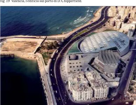
he theme of the waterfront, of the façade overlooking the water, of the relation-ship between the city and the sea, between the city and the port, is a field of research and intervention of vast importance to design and planning. The waterfront, for the authors of this publication, represents a topic of constant exploration and experimenta-tion, shared with numerous colleagues and professionals. The waterfront understood as a space in-between, as a margin between two parts, now considered distinct, autonomous, and in conflict. This separation depends, above all in large port areas, on a plurality of reasons: diverse modalities of planning (the port plan on the one hand, and urban planning on the other), various administrative responsibilities, the incompatibility between port activi-ties and urban activiactivi-ties, and increased needs related to the efficiency, safety and flexibility of ports. While in the past the harbour was an integral part of the city, it is now an extraneous body, detached and in conflict with urban necessities. The port closes in on itself, while simultaneously requiring the city, its services, the infrastructures that cross the territory. The city on the other hand has rediscovered its ties with the sea, with the port, with its centrality, both visual and with the landscape. In Italy there was a lack of a true process of decentralising si è sviluppata su aree portualidismesse e sotto utilizzate, in Italia i grandi porti continuano ad essere operativi nel cuore delle città. Nel nostro Paese la riqualificazione del waterfront si identifica con un progetto di integrazione, capace di mantenere l’autonomia funzionale del porto, ma allo stesso tempo di aprire il porto allo sguardo e all’uso della città. È all’interno di questa problematica che sono state messe a punto le nozioni di aree di sovrapposizione città-porto e di filtering line. Quest’ultima è intesa come concept progettuale per l’inte-grazione tra la città e il porto e, più in generale, tra l’infrastruttura e il contesto. Il concept è stato applicato in numerosi progetti per la riqualifica-zione dei waterfront urbani presen-tati nel libro: da Marina di Carrara, a Napoli, Rapallo, Los Cristianos di Tenerife, Pescara, Bari, Taranto. I progetti di riqualificazione dei waterfront esigono un organico rapporto tra la dimensione urbani-stica e quella architettonica. In questa direzione, un fertile scambio di collaborazione e di esperienze si è stabilito all’interno di un gruppo di lavoro in cui hanno collaborato, in particolare, Rosario Pavia, Matteo di Venosa, Raffaella Massacesi, Danilo Romani, Guendalina Salimei. L’attività di progettazione si è avvalsa, inoltre, di un costante lavoro di ricerca nel settore della pianificazione portuale
port activities. While in Barcelona, Marseille, Amsterdam and Baltimore the requalification of the waterfront was developed in decommissioned and under-utilised port areas, in Italy large harbours continue to operate in the heart of many cities. In our country, the redevelopment of the waterfront is identified with a project for integration, capable of maintaining the functional autonomy of the port and, at the same time, of opening the port towards observation and use by the city. It is within this problematic framework that notions of areas of overlap between city-port and that of the filtering line have been defined. This latter is understood as a design concept focused on an integration between the port and the city and, more in general, between infrastructure and context. This concept has been applied in numerous projects for the requalification of urban waterfronts presented in this book: from Marina di Carrara to Naples, Rapallo, Los Cristianos in Tenerife, Pescara, Bari and Taranto. Projects for the redevelopment of waterfronts require an organic relation-ship between the urban dimension and that of architecture. In this direction, a fertile exchange of collaboration and experiences was established amongst a work group composed, in particular, of Rosario Pavia, Matteo di Venosa, Raffaella Massacesi, Danilo Romani and Guendalina Salimei. The
activi-(dalla ricerca CNR sui piani regolatori portuali, alla consulenza prestata al Consiglio Superiore dei Lavori Pubblici per le Linee guida per la redazione dei
piani regolatori portuali, allo studio di
fattibilità del Corridoio Adriatico, agli indirizzi progettuali per i porti delle Regioni Emilia Romagna e Abruzzo, al piano portuale di Corigliano Calabro e di Pescara, al Progetto Sea Bridge). In Italia il tema del waterfront, impostosi con ritardo, assume una sua specificità. La complessità dei contesti portuali, l’intreccio inevi-tabile tra porto e città, tra porto e territorio e paesaggio aprono la proble-matica verso soluzioni necessaria-mente innovative e sperimentali. Con lo sviluppo del traffico marittimo nel Mediterraneo e il conseguente, necessario processo di modernizza-zione dei porti, il waterfront diverrà sempre più un’area su cui si concentre-ranno investimenti infrastrutturali e programmi di riqualificazione urbana. Sul waterfront si svilupperà sempre di più una competizione progettuale e di confronto tra engineering, archi-tettura, urbanistica e management. Allo sviluppo di questo confronto si intende dare un contributo conoscitivo ed operativo con un libro che raccoglie e organizza una serie di interventi di ricerca e di sperimentazione progettuale Il libro è stato organizzato in più sezioni: nella prima, introduttiva, si è
ripercorso il processo di trasformazione del rapporto tra la città e la sua area portuale fino all’affermazione del tema del waterfront; nelle successive sezioni si è analizzato il waterfront come interfaccia del conflitto e dell’integra-zione. Una sezione specifica è stata dedicata al tema dei porti minori, che per la numerosità dei comuni costieri italiani costituisce una problematica di grande rilievo. La presentazione delle esperienze progettuali, curata da Raffaella Massacesi, fornisce un quadro del complesso rapporto tra ricerca e verifiche operative. In ultimo, nella sezione conclusiva per
correr miglior acque, si avanzano
alcune ipotesi di ricerca: il tema del waterfront da analizzare in relazione allo sviluppo dei sistemi portuali come piattaforme logistiche intercon-nesse alle reti territoriali e l’emergere di una nuova domanda di integra-zione, non solo tra porto e città, ma anche tra porto e paesaggio.
ties of design also employed a constant process of research in the field of port planning (from CNR research into port plans to consultancy services offered by the Consiglio Superiore dei Lavori Pubblici for the Guidelines used in the
preparation of port master plans, to the
feasibility study Corridoio Adriatico, to the design guidelines for the ports of the Region of Emilia Romagna and Abruzzo, to the port master plan for Corigliano Calabro and Pescara, and the Sea Bridge Project). In Italy the theme of the waterfront, late in impos-ing itself, assumes a highly specific connotation. The complexity of port contexts, the inevitable interweaving between port and city, between port, territory and landscape, broaden the problem towards necessarily innovative and experimental solutions.
With the development of maritime traffic in the Mediterranean, and the consequent, necessary process of modernising ports, the waterfront will become progressively more an area within which to concentrate infrastruc-tural investments and programmes of urban requalification. The waterfront will be increasingly more the object of a design competition and comparisons between engineering, architecture, urban planning and management. The development of this comparison intends to offer a cognitive and opera-tive contribution through a publication that collects and organises a series of
interventions of research and design experimentation.
This book has been organised in multi-ple sections: the first, introductory, retraces the process of transforming the relationship between the city and its port area, to the affirmation of the theme of the waterfront; the successive sections analyse the waterfront as an interface of conflict and integration. A specific section has been dedicated to the theme of minor harbours that, in light of the vast number of Italian coastal communities, constitutes a problem of significant importance. The presentation of design experi-ences, curated by Raffaella Massacesi, provides an understanding of the complex relationship between research and operative verifications. Finally, the conclusive section, per correr miglior
acqua (to navigate better waters),
advances a number of research hypoth-eses: the theme of the waterfront to be analysed in relation to the devel-opment of port systems as logistics platforms, interconnected with territo-rial networks and the emergence of a new demand for integration, not only between the port and the city, but also between the port and the landscape.
Introduction
Introduzione
a14 a15
Rosario Pavia
Urban Ports
Rosario Pavia
I Porti delle città
Il processo è in pieno svolgimento e si intensificherà nei prossimi anni. La globalizzazione dei mercati e l’incremento degli scambi commerciali a scala mondiale trovano nel trasporto marittimo e nei grandi porti il loro spazio funzionale e simbolico. Oggi le aree portuali si sono definitivamente separate dai centri urbani, acquisendo un’autonomia che non troviamo nelle città del passato. Per questo è più appropriato parlare di porti delle città piuttosto che di città-porto. Mentre in passato l’identità urbana si integrava completamente con quella del porto, ora la relazione tra le due parti appare straordinariamente intricata e discon-tinua. La città e il porto assumono identità distinte, opposte, con relazioni dinamiche, complesse, ma nello stesso tempo, nella loro molteplicità, settoriali e parcellizzate.
La nuova identità del porto è tuttavia incomprensibile senza una riflessione sul distacco delle aree portuali dalla struttura urbana, sul momento e le ragioni di quella separazione che, cancellando i tradizionali rapporti funzionali, visivi e sociali hanno intro-dotto esigenze nuove e contrastanti. Se da un lato, infatti, i grandi porti richie-dono con determinazione più autono-mia, dall’altro le città rivendicano più integrazione e dialogo. Cercheremo
con le note seguenti di ricostruire il processo che dalla unitarietà della città-porto ha prodotto prima la frattura tra le due parti e successivamente, ma siamo già nell’attualità, una forte domanda di ricomposizione e di integra-zione.
La citta-porto
Nel passato l’identità urbana, come la sua forma, comprendeva quella del porto. Questa organicità è chiaramente rintracciabile non solo nelle rappresen-tazioni planimetriche e nelle vedute delle città portuali dal Medioevo al XIX secolo, ma nella stessa trattatistica del classicismo che, a partire da Leon Battista Alberti, inserisce il porto tra gli edifici pubblici delle città. Il porto, visto come un’architettura, come un progetto unitario, si inserisce nel disegno complessivo della città. Il porto è organicamente correlato alle altre parti urbane, in tal senso rientra nel principio della città “come corpo”1. La
fonte obbligata per i trattatisti rinasci-mentali è Vitruvio che nel De
Archi-tettura esemplifica la sua conoscenza
in materia portuale attraverso la descrizione del porto di Alicarnasso. La precisione dei riferimenti vitruviani consentì a Cesare Cesariano di raffi-gurare il porto di Alicarnasso come un sistema di banchine semicircolari a
The globalisation of markets and an increase in commercial trading at the global scale see maritime transport and large ports as the their functional and symbolic space. Today port areas are definitively separated from urban centres, acquiring an autonomy unfound in the cities of the past. For this reason it is more appropriate to speak of city ports rather than port-cities. While in the past urban identity was completely integrated with that of the port, the relation between the two parts now appears to be extraordinar-ily intricate and discontinuous. The city and the port assume distinct and opposing identities, with dynamic and complex relations that, at the same time, as a result of their multiplicity, are both circumscribed and subdivided. The new identity of the port is incom-prehensible without a reflection on the separation of port areas from the urban structure and the moment of and reasons for this separation that, while cancelling traditional functional, visual and social relations introduced new and contrasting requirements. In fact, if on the one hand large ports require, with determination, more autonomy, on the other cites call for more integration and dialogue. In the following notes we will seek to reconstruct the processes that, from the unity of the port-city, produced
the first fracture between the two parts and, successively, though we are already in the present, a strong demand for recomposition and integration.
The Port-City
In the past, urban identity, like its form, included that of the port. This organic quality can be found not only in plans and views of port cities from the medie-val period to the 19th century, but also in the treatises of classicism that, belonging with Leon Battista Alberti, insert the port amongst the city’s public buildings. The port, seen as a work of architecture and as a unitary project, is inserted in the comprehensive design of the city. The port is organically correlated to other urban elements and, in this sense, belongs to the principle of the city “as a body”1.
The obligatory source for Renaissance treatise writers is Vitruvius who, in his De Architettura, exemplifies his understanding of ports through the description of the port of Halicar-nassus. The precision of Vitruvian references allows Cesare Cesarino to represent the port of Halicarnassus as a system of semi-circular docks in the form of a cavea or “teatri curvaturae similis” (fig 1). The port was closely connected to the city that overlooked the harbour and the spectacle of the
cavea, “teatri curvaturae similis” (fig 1). Il porto era strettamente connesso alla città che si affacciava sulla rada e sullo spettacolo delle navi. Il riferimento al porto come teatro è ricorrente nei trattatisti tra ‘400 e 700. Per Leon Batti-sta Alberti “ogni città di mare è troppo vaga”, di una bellezza particolare, attraente, per cui intorno al porto non solo raccomandava la presenza di magazzini, di piazze mercantili, di edifici di servizio, di templi, ma anche di portici e di “luoghi da passeggiare” 2.
Antonio da Sangallo giunse a proporre sulla copertura dei magazzini e dei portici un percorso pedonale e un belvedere. La ricostruzione del porto di Alicarnasso3 di Cesare Cesariano
traduceva con efficacia l’unitarietà del porto-città; il tessuto urbano del pendio scendeva fino all’ area retroportuale dove era collocata, come spazio di mediazione, una grande piazza mercan-tile al cui centro si ergeva il mausoleo del sovrano. La piazza era divisa in due parti: la prima direttamente a contatto con il porto, “litus et emporium”, desti-nata alle manovre di imbarco e scarico delle merci, la seconda, più interna, per le funzioni propriamente mercantili per le quali occorrevano ampiezza ed attrezzature, “emporium seu platea ampla latitudine”. Tra le due piazze si sviluppava il muro di cinta della città, le mura urbane entravano nel porto, ne facevano parte. L’area portuale era difesa da torri che vigilavano
sull’imboccatura (l’Alberti raccoman-dava ancora di chiudere l’accesso al porto con delle lunghe catene, da far poggiare al fondo e tendere al momento opportuno). Ma le mura pur separando il porto dalla città non lo escludevano dalla vita urbana. Le operazioni portuali erano svolte solo in parte sui moli e le banchine, il cuore dell’attività commerciale del porto era concentrato al di là delle mura. Qui erano localizzati la piazza del mercato, i magazzini, le logge dei mercanti, le chiese, i palazzi, gli edifici più rappresentativi della città.
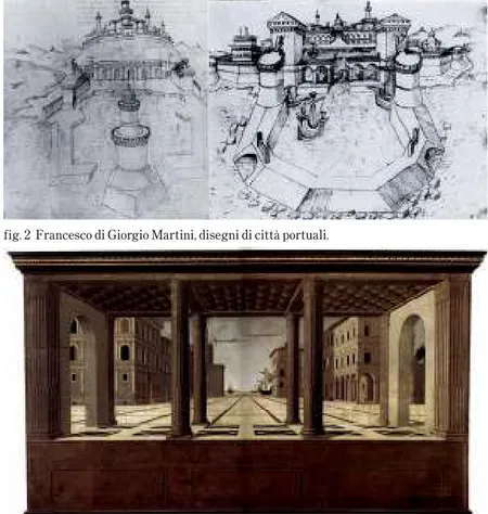
L’organicità della città porto era garan-tita da un disegno urbano unitario. In proposito è sufficiente esaminare i disegni di città portuali di Francesco di Giorgio Martini (fig 2) 4. La figura del
porto è commisurata a quella della città, il cui impianto geometrico ortogonale include gli spazi retroportuali. La cinta muraria con la fortezza entra nel bacino del porto funzionando come infra-struttura di difesa e opera marittima. Francesco di Giorgio Martini incarna l’unitarietà della disciplina progettuale rinascimentale: ingegneria militare, idraulica, architettura e urbanistica si fondono insieme. La sua attenzione allo spazio portuale non si esaurisce in modelli planimetrici, ma entra in merito alle dimensioni dell’imboc-catura (200-250 piedi, circa 60-70 metri), alla sua protezione mediante un antemurale (lungo 300 piedi e largo 80),
sailing ships. The reference to the port as a theatre recurs in treatises from the 15th to 18th centuries. For Leon Battista Alberti, “any seaside city is too vague”, with a particular beauty, attractive and, for this reason, around the port he recommend not only the presence of warehouses, mercantile squares, service buildings and temples, as well as “spaces for strolling”2.
Antonio da Sangallo later proposed that the roofs of warehouses and porticos be covered with a pedestrian walkway and belvedere.
Cesare Cesariano’s reconstruction of the port of Halicarnassus3
effec-tively translated the unitary nature of the port-city; the urban fabric of the hillside dropped down to the area behind the port, a space of mediation home to a large mercantile square whose centre featured the mausoleum of the city’s ruler. The square was divided into two parts: the first in direct contact with the port, “litus & emporium”, destined for manoeuvres related to the loading and off-loading of goods while the second, more internal, was for more mercantile functions that required vast spaces and equipment, “emporium seu platea ampla latitudine”. Between the two squares ran the city walls, with the urban wall entering into the port and becoming part of it. The port area was now defended by towers guarding the harbour mouth (Alberti still recommended closing the access to
the port with large chains that rested on the seafloor and could be realised at the opportune moment). However, while the walls separated the port from the city, they did not exclude it from urban life. Port operations took place only in part on the wharves and docks, with the heart of commercial activi-ties in the port concentrated beyond the walls. This area was home to the market square, the warehouses, the merchant’s loggias, the churches, the palaces and the city’s most representa-tive structures.
The organic nature of port-cities was guaranteed by a unitary urban plan. As an example, it is sufficient that we examine the designs of the port city by Francesco di Giorgio Martini (fig 2)4. The figure of the port is
proportionate with that of the city, whose orthogonal geometric layout includes the areas of the dry port. The city walls and fortress enter into the harbour, functioning as an infrastruc-ture of defence and maritime protec-tion structure. Francesco di Giorgio Martini embodies the unitary nature of the discipline of Renaissance design: military and hydraulic engineering and architecture and urban planning are fused together. His attention to the space of the port is not exhausted in plan models, but enters into the merit of the dimensions of the harbour mouth (200-250 feet, approx. 60-70 meters), its protection with a breakwater (300
a18 a19 alle modalità di costruzione di un porto
interamente artificiale. La tecnica indicata è esemplare: prima, ad una distanza dalla costa di circa1500 piedi (circa 450 mt), vengono costruite due torri, destinate a difendere l’imboc-catura del porto, successivamente vengono connesse alla terra ferma con due moli convessi o poligonali. Le due torri sono l’avamposto della città, indicano che oltre l’imboccatura inizia uno spazio che è già urbano.
Per i porti molto grandi Francesco di Giorgio, sul modello dell’antico porto di Ostia, raccomandava di costruire un avamporto delimitato da semplici moli e un porto interno banchinato, ricavato sulla costa. Il primo con funzioni di difesa e di ormeggio, il secondo con funzioni più propriamente di scalo merci, circondato da “strade, portici e magaz-zini, acciò che li mercanti vi possino ridursi a stare e le mercanzie caricare e scaricare con facilità e comodità” 5.
L’equilibrio tra città e porto, così presente nei modelli planimetrici del trattato di Francesco di Giorgio Martini, lo ritroviamo nella tavola di Berlino (attribuita allo stesso France-sco di Giorgio) in cui viene rappre-sentata una piazza di una città ideale aperta su un porto (fig 3). La prospet-tiva centrale dà unitarietà allo spazio della piazza, la cui perfetta geometria è esaltata dall’assenza di pubblico. Il vuoto della piazza si anima, tuttavia, sullo sfondo, nel punto di fuga, dove
alcune navi avanzano verso il porto con le vele spiegate.
Il forte legame tra la città e il porto, trova in questa scena ideale la sua rappresentazione simbolica più alta. Al forte legame spaziale corrisponde-vano relazioni sociali ed economiche altrettanto profonde. In Italia, per tutto il ‘500, nonostante l’affermarsi degli stati territoriali e delle rotte atlantiche, città portuali come Genova e Venezia continuarono ad accrescere la loro potenza fondata sul commercio e il trasporto marittimo.
Venezia era nella sostanza un grande porto. La città e il porto si fondevano in sistema unico. L’arsenale era un pezzo di città; cantiere, porto militare, centro direzionale e laboratorio di ricerca; il canale della Giudecca un’immensa banchina. Ma erano Piazza S. Marco e la contigua Piazzetta, rimodellata dal Sansovino, a costituire il fulcro della vita della città e del porto, lo spazio scenografico in cui il potere religioso si incontrava con quello aristocratico mercantile. Le navi più importanti attraccavano infatti qui sulle banchine della Piazzetta S. Marco, nel luogo più rappresentativo della città6. La simbiosi
tra spazio portuale e spazio urbano era totale. A Venezia non c’erano mura, la sua difesa avveniva altrove in terra ferma, alle bocche della laguna, nel suo golfo adriatico, nelle lontane isole del Levante. Diversamente a Genova l’area portuale viveva in stretto rapporto
feet or 80 meters in length) and the methods of constructing an entirely artificial port. The technique indicated is exemplary: firstly, at a distance from the coast of some 1,500 feet (approx. 450 meters), two towers are to be constructed, destined to defend the harbour mouth. This is followed by the connection to the terra ferma of two convex or polygonal docks. The two towers are the outposts of the city, indicating the beginning, just beyond the harbour mouth, of a space that is already urban.
For very large ports, Francesco di Giorgio, using the model of the ancient port of Ostia, recommended the construction of an outer-port delimited by simple wharves and an internal port with docks, created along the coast. The first was to function as a defensive structure and docking area, the second for the loading/unloading of goods, surrounded by “streets, porticos and warehouses, by that which merchants require and such that merchant ships are able to load and unload their goods with ease and simplicity”5.
The equilibrium between the city and the port, so clear in the plan models of the treatise by Francesco di Giorgio Martini, can also be found in the drawing of Berlin (also attributed to Francesco di Giorgio) that represents a public square of an ideal city open to a port (fig 3). The central perspective gives unity to the space of the square,
whose perfect geometry is exalted by the absence of any figures. The void of the square is animated, nonetheless, in the background, by the vanishing point, where a number of ships advance towards the port with their sails open. The strong tie between the city and the port finds, in this ideal scene, its highest symbolic representation. The strong spatial tie corresponds with equally profound social and economic relations. In Italy, throughout the 1500s, notwithstanding the affirma-tion of territorial states and Atlantic shipping routes, port cities such as Genoa and Venice continued to increase their power founded on commerce and maritime transport.
In substance, Venice was a large port. The city and the port were fused in a single system (fig 4). The arsenal was a piece of the city; shipyard, military port, business centre and research laboratory; the Giudecca Canal was simply an immense dock. However, it was the Piazza S. Macro and the contig-uous Piazzetta, remodelled by Sanso-vino, which constituted the fulcrum of life in the city and the port, the sceno-graphic space in which religious power met that of the aristocratic merchant class. In fact, the most important ships docked at the Piazzetta S. Macro, in the most representative space of the entire city6.The symbiosis between port
space and urban space was complete. In Venice there were no walls, its defence
fig. 1 Il porto di Alicarnasso nella descrizione di Cesare Cesariano. fig. 3 Francesco di Giorgio Martini, tavola di Berlino. fig. 2 Francesco di Giorgio Martini, disegni di città portuali.
a22 con la cinta muraria che proprio
nella seconda metà del ‘500 iniziò a rinnovarsi, sia sul fronte mare, sia, e più intensamente nei decenni successivi, lungo la cinta rivolta all’entroterra (fig 4) 7. Alla realizzazione della magnifica
Via Nova, nella parte alta della città, sul fronte marino corrispondeva il rinnovamento dell’Arsenale, di Piazza dei Banchi, di via Balbi, del Palazzo S. Giorgio (già Palazzo del Mare), del sistema viario a ridosso dei ponti (ovvero i moli) Calvi, Spinola e dei Cattanei. Sul Molo vecchio, prolungato e arricchito di nuovi magazzini, la monumentale Porta di Galeazzo Alessi (1553), incastonata nel baluardo delle mura, era il simbolo della potenza raggiunta dalla marineria genovese, e nello stesso tempo della debolezza di una città stato schiacciata dai grandi stati territoriali in espansione.
Sopra i porti di mare
L’elaborazione teorica sulla proget-tazione delle aree portuali assume nel corso del ‘500 un carattere più specialistico. L’esigenza di adeguare le fortificazioni cittadine alla nuova potenza delle artiglierie, porta ad estendere le misure difensive nell’a-rea portuale. L’ingegneria militare condiziona la forma e la struttura dei moli trasformandoli in mura. I disegni di Pietro Cataneo8 per le città-emporio e
per le città regali marittime, assimilano gli spazi portuali alle aree urbane: città
e porti sono all’interno del medesimo sistema difensivo (fig 5). La figura geometrica della città fortificata, ingloba il porto, inserendolo in un dispositivo difensivo che subordina alle mura cittadine le attrezzature portuali commerciali. Il porto diventa uno spazio per l’attracco e la difesa delle navi. Dalle banchine, molto limitate per estensione e profondità, le merci vengono immediatamente trasportate in città mediante una serie di portelle ben difese dalla cinta muraria bastio-nata. Le attrezzature commerciali come il mercato, i magazzini, la borsa sono all’interno delle mura, ma vicino al porto, “in una o più spaziose e porticate piazze, nella estrema fronte della città”. Il fronte urbano sul porto finisce con il coincidere con il recinto murario. Sulla sommità delle mura troviamo non solo artiglierie, ma anche camminamenti ed eccezionali punti di osservazione sul porto. L’aspetto spettacolare dello spazio portuale si accentua nel secolo successivo ed è rintracciabile anche in un testo tecnico come quello di Teofilo Gallacini Sopra li porti e di mare, dove troviamo tra le raccomandazioni: “il porto deve esser fatto di buon disegno, cioè con bella forma”, e in proposito della dimensione del molo, questo deve essere “largo che si possa passeggiare con le carrozze” 9.
La rigidità geometrica dei modelli di città marittime fortificate proposti dai
trattatisti militari si stempera nella fig. 5 Pietro Cataneo, disegni di città emporio.
fig. 4 L’area portuale di Genova nella seconda metà del 1500.
pratica degli interventi. Le fortifi-cazioni si adeguano alla morfologia dei luoghi. Vasari con pragmatismo raccomandava di “accomodarsi al sito”.E’ l’elemento difensivo, tuttavia, a caratterizzare i bacini portuali le cui imboccature sono difese da imponenti fortezze, cosi’ a Messina, a Palermo, a Siracusa, a Trapani. Forse solo Livorno nel corso del ‘500, con gli interventi diretti dal Lanteri, riesce a trovare un equilibrio tra espansione del porto e sistema difensivo della città. I porti fortificati del ‘500, in un Mediterraneo minacciato dal Turco, testimoniano ancora la vitalità economica e culturale di questo mare interno il cui declino è già alle porte.
Lo sviluppo delle rotte atlantiche e l’espansione colonialista dei grandi stati europei, fanno emergere rapida-mente il ruolo strategico dei porti atlantici. In Francia Colbert e Richelieu promuovono la realizzazione di nuove infrastrutture portuali a Brest, Dunker-que, Laurient, Rochefort, trasformando radicalmente gli approdi preesistenti. Ma mentre in Francia le città portuali risentono ancora fortemente dell’in-fluenza dell’architettura classica di Blondel e dell’ingegneria militare di Vauban10, in Inghilterra e in Olanda
le aree portuali, verosimilmente per la diversa natura geografica (i porti sono connessi al mare da fiumi), hanno uno sviluppo più libero dalle regole compositive dalla geometria della città.
Londra espande il suo porto lungo le rive del Tamigi, Amsterdam, grazie alla sua rete di canali, riesce a realiz-zare all’interno della cinta muraria, nuove banchine e nuove darsene. Ma è soprattutto a Rotterdam che lo schema della città-porto inizia ad articolarsi in più poli funzionali, distribuiti lungo il fronte della Schelda. Comincia ora a delinearsi la diversità delle città portuali del Nord Europa rispetto a quelle del Mediterraneo. In Inghilterra, nei Paesi Bassi, in Germania, la rete fluviale e il sistema dei canali (che entrano a far parte delle stessa morfo-logia urbana), si saldano al mare, realiz-zando uno straordinario complesso infrastrutturale fondato sulla acqua e la sua navigabilità. Giovanni Botero è stato il primo a mettere in evidenza il ruolo della “condotta” nello sviluppo delle città e come la “comodità che ci porge l’acqua” fosse superiore “a quella che ci dà la terra”11. A guardare bene è
proprio la struttura delle reti d’acqua a sostenere il futuro decentramento delle attività portuali dalla città nel territorio circostante. Come vedremo tale processo sarà più lento nell’Europa mediterranea e in particolare nella realtà italiana.
L’unitarietà visiva e funzionale della città porto si manterrà in ogni caso a lungo. La cultura classicistica che informa l’Accademia e la trattatistica e che porta a considerare il porto come un’architettura, come un edificio
took place elsewhere, on terra ferma, at the mouths of the lagoon, in its Adriatic gulf, on the far eastern islands. In different terms, Genoa’s port area was in close relationship with the city walls that were renewed during the second half of the 1500s, both along the seafront as well as, and more intensely in the following decades, along the portion facing inland (fig 4)7. The realisation of the magnificent
Via Nova, in the upper part of the city, corresponded, along the seafront, with the renewal of the Arsenal, the Piazza dei Banchi, the Via Balbi, Palazzo S. Giorgio (formerly Palazzo del Mare), the viability system alongside the Calvi, the Spinola and Cattanei bridges (the docks). Along the Molo Vecchio, extended and enriched with new warehouses, the monumental Gate by Galeazzo Alessi (1553), set into the bastion of the city walls, was the symbol of the power achieved by the Genoese navy and, at the same time, the weakness of a city crushed by large expanding territorial states.
Above the Sea Ports
During the 1500s the theoretical elaboration of designs for port areas assumed a more specialised character. The need to adapt city fortifications to repel new artillery power led to the extension of defensive measures in port areas. Military engineering conditioned the form and structure of the docks,
transforming them into walls. The designs by Pietro Cataneo8 for the
city-emporium and for regal maritime cities compare the spaces of the port to urban areas: cities and ports are found inside the same defensive system (fig 5). The geometric figure of the forti-fied city envelops the port, inserting it within a defensive system that subordi-nates the commercial port structures to the city walls. The port becomes a space for docking and defending ships. From the docks, limited in their extension and depth, goods can be immediately transported to the city via a series of gates that were well defended from bastions along the city walls. The commercial facilities, such as the market, warehouses and the stock exchange, were located inside the walls, though near the port, “in one or more spacious and porticoed public squares, along the extreme front of the city”.
The urban front facing the port ends where it coincides with the city walls. Along the top of the walls we find not only artillery, but also walkways and exceptional points of observa-tion overlooking the harbour. The spectacular aspect of the port space is accentuated in the following century and can be traced back to a technical text such as that by Teofilo Gallacini Sopra li porti e di mare, that contains recommendations such as: “the port must be well designed, that is with a
a26 a27 pleasing form”, and with regards to the size of the docks, it states that they must be “large enough for the passage of carriages”9.
The geometric rigidity of the models of the fortified maritime city proposed by writers of military treatises is tempered in the practical nature of the interventions. The fortifications are adjusted to meet the morphology of the site. Vasari, with pragmatism, recom-mended, “adjusting the project to meet the site”. All the same, it was the defen-sive element that characterized the port dock areas, whose openings were defended by imposing fortresses, as seen in Messina, Palermo, Syracuse and Trapani. Perhaps only Livorno, under the interventions directed by Lanteri during the 1500s, managed to find a balance between the expansion of the port and the city’s defensive system. The fortification of ports in the 1500s, when the Mediterranean was threat-ened by the Turks, testified once again to the economic and cultural vitality of this internal sea, whose decline was already in the cards.
The development of Atlantic routes and the colonial expansion of large European states led to the rapid emergence of the strategic role of Atlantic ports. In France, Colbert and Richelieu promoted the realization of new port infrastructures in Brest, Dunkirk, Laurient and Rochefort, radically transforming the pre-existing
docks. However, while France’s port cities remained strongly under the influence of the classical architecture of Blondel and the military engineering of Vauban10,port areas in England and
Holland, comparable for their diverse geographic nature (the ports are connected to the sea by rivers), were witness to a form of development free of the compositional rules governing the geometry of the city.
London expanded its port along the banks of the Thames, while Amster-dam, thanks to its network of canals, managed to realise new docks and shipyards within the walls of the city. However, it was above all in Rotter-dam that the scheme of the port-city began to articulate itself in multiple functional centres, distributed along the Schelda River. This was the begin-ning of the delineation of the diversity of the port cities of Northern Europe with respect to those of the Mediter-ranean. In England, the Netherlands and Germany the network of rivers and systems of canals (that become part of the very morphology of the city), are fused with the sea, creating an extraordinary infrastructural system founded on waterways and their naviga-bility. Giovanni Botero was the first to highlight the role of the “conduit” in the development of the city as the “commodity offered by water”, perhaps superior to “that offered by land”11.
On close inspection, it is precisely the pubblico della città, permarrà fino alla
prima metà del XIX sec.
I concorsi promossi dall’Accademia di S. Luca nei primi decenni del ‘700, nella loro enfasi, testimoniano l’interesse dello Stato Pontificio nei confronti del ruolo strategico dei porti. Oggetto del concorso del 1728 è una “piazza in elevazione con vista di un porto di mare, quello del 1732 una città in mezzo al mare,” quello del 1739 “una gran piazza di città metropoli dotata di porto”. “Tra i progetti presentati compaiono alcuni di architetti di valore come Carlo Marchionni (fig 6), Bernardo Vittone, Carlo Sala (fig 7), Vincenzo Silva12. Tutte le soluzioni
presentate propongono impianti rigoro-samente geometrici con cinte murarie avvolgenti l’area portuale. Sono città ideali, città di fondazione incardinate su una simmetrica corrispondenza tra il bacino portuale e la grande piazza aperta sul mare. Alla fine del ‘700 Francesco Milizia è ancora immerso in questa cultura classicista. Nei suoi
Principi di architettura civile
classi-fica i porti tra gli edifici di “ragion pubblica”, individuando per esse le fabbriche necessarie, dai magazzini, alle dogane, agli arsenali, alla borsa13.
Per tutte le fabbriche, anche per i fari, raccomanda il ricorso alla decorazione e agli stili architettonici. Per gli aspetti tecnici relativi alla costruzione dei moli rimanda agli insegnamenti dell’inge-gnere Bernard Forest de Bélidor14 che
nel 1737-39 aveva scritto un trattato di idraulica applicata all’architettura. In effetti, nel corso del ‘700, con l’afferma-zione in Francia de l’Ecole des Ponts et
Chaussés, si delinea una articolazione
delle competenze disciplinari ed opera-tive. L’architettura si separa lenta-mente dall’ingegneria; i testi si fanno specialistici, i riferimenti applicativi più circoscritti alle opere da eseguire. Così negli scritti teorici sui porti di Giuliano De Fazio, ingegnere del Corpo di Ponti e strade del Regno delle due Sicilie15, le soluzioni proposte sono tutte
rappresentate con scarsi riferimenti al contesto urbano. Il distacco dell’archi-tettura dall’ingegneria sarà tuttavia lento, in molti manuali specialistici, come il Nuovo corso completo di
pubbli-che costruzioni di Mattia Giuseppe
Sganzin, scritto in Francia all’inizio dell’800, ma pubblicato in Italia solo nel 1849, è evidente l’attenzione agli aspetti formali: non solo interessa la buona costruzione, il dispositivo funzionale e distributivo, ma anche la decora-zione e la qualità stilistica delle opere. Attraverso le scuole politecniche, la catalogazione tipologica e il riferimento alle buone pratiche manterranno vivo, ancora per molto, il dialogo tra architet-tura e ingegneria16.
L’architettura
della città porto
Nel porto come grande edificio pubblico, organicamente connesso alla
structure of waterways that supports the future decentring of port activities from the city to the surrounding terri-tory. As we will see, this process would be slower in Mediterranean Europe, and in particular in Italy.
The visual and functional unity of the port-city was maintained, in any case, for a lengthy period of time. The classicist culture that fed the Academic world and its treatises and which led to the consideration of the port as a work of architecture, similar to a public building in the city, would remain intact until the middle of the 19th century.
The competitions promoted by the Academia of S. Luca during the early 1700s, in their emphasis, testify to the interest of the Papal State in the strategic role of ports. The object of a competition in 1728 was “an elevated public square with a view of a seaport”, while another in 1732 called for “a city in the middle of the sea” and, in 1739, for “a large public square for a metropolitan city with a port”. “Of the projects presented, there are some by architects of such importance as Carlo Marchionni (fig 6), Bernardo Vittone, Carlo Sala (fig 7) and Vincenzo Silva12.
All of the solutions presented propose rigorously geometric structures with city walls wrapping around the area of the port. They are ideal cities, newly founded cities centred on a symmetric correspondence between the harbour
and the large open public space facing the sea. At the end of the 18th century, Francesco Milizia was still immersed in this classicist culture. In his Principi di architettura civile, he classifies ports amongst “public buildings”, identify-ing the necessary structures, from warehouses to customs houses, from arsenals to stock markets13. For all of
the buildings, even lighthouses, he recommends decorations and architec-tural styles. For the technical aspects related to the construction of docks, he refers back to the teachings of the engineer Bernard Forest de Bélidor14
who, between 1737-39, wrote a treatise on hydraulics applied to architecture. In reality, during the 18th century, the affirmation in France of the Ecole des Ponts et Chaussés delineated an articulation of disciplinary and opera-tive competences. Architecture was slowly separated from engineering; texts became more specialised, applied references more applicable to the works to be completed. Thus, the theoreti-cal writings on ports by Giuliano De Fazio, an engineer with the Corpo di Ponti e strade del Regno delle due Sicilie15, proposed entirely
representa-tive solutions, with scarce references to urban context. The separation between architecture and engineering was, in any case, a slow one, in many special-ised manuals, such as the Nuovo corso completo di pubbliche costruzioni by Mattia Giuseppe Sganzin, written in città, ha operato a lungo l’architetto
come figura autorevole in grado di dominare l’insieme della disciplina del costruire. L’organicità del rapporto tra città e struttura portuale trova una chiara corrispondenza nella polivalente ed unitaria cultura dell’architetto definito da Leon Battista Alberti. Nella trasformazione dei porti italiani, dal ‘400 all’ ‘800 l’architetto è presente con evidenza: Bramante, Michelan-gelo e Sangallo sono impegnati nella fortificazione del porto di Civitavec-chia, Leonardo ci ha lasciato i disegni dei porti di Piombino e Civitavecchia, il Buontalenti opera a Livorno, il Sanmicheli interviene nella laguna di Venezia, l’Alessi costruisce la Porta del Molo Vecchio a Genova, a Civita-vecchia Bernini progetta l’arsenale, a Napoli Carlo Fontana interviene nell’area portuale di Castelnuovo, a Messina operano Jacopo del Duca e Filippo Juvarra, ad Ancona il porto si rinnova con Luigi Vanvitelli. Tra il “600 e l’inizio dell’”800 la capacità del progetto di architettura di integrare le esigenze portuali con quelle della città raggiunge la piena maturità. Gli inter-venti nelle aree portuali di Messina, di Ancona, di Trieste e Genova lo dimostrano ampiamente.
A Messina, Jacopo del Duca realizza all’inizio del XVII sec. il palazzo Senatorio direttamente sul fronte marino in stretto rapporto con le banchine portuali17. Il maestoso
edificio ha una struttura complessa e polivalente, funzionando come loggia mercantile, borsa e palazzo comunale. L’edificio viene costruito abbattendo un tratto delle preesistenti mura normanne. E’ l’inizio della sostitu-zione della cinta muraria a mare con quella straordinaria opera che sarà chiamata palazzata o teatro marittimo. In realtà la palazzata fu realizzata tra il 1622 e il 1625 per volontà del Vicerè Emanuele Filiberto di Savoia (figlio di Carlo Emanuele che in quegli stessi anni stava riorganizzando la struttura urbanistica di Torino), che affiancò all’architetto Simone Gulli l’ingegnere piemontese Antonio Donzello. La palazzata, inglobando le antiche porte, si affacciava direttamente sul mare con una concentrazione lineare di edifici caratterizzati da un disegno unitario (vincolante per gli acquirenti dei lotti ricavati dall’abbattimento delle mura). La palazzata realizzava il sogno di un affaccio della città sul teatro del porto di Messina, nello stesso tempo, per chi veniva dal mare, la città sembrava accogliere i naviganti con un largo e continuo abbraccio. La grandiosità di questo teatro marittimo che integrava in un sistema unitario il sito geogra-fico, il bacino portuale, la morfologia urbana, fu immediatamente colta dalle vedute di Filippo Juvarra che proprio qui, a Messina, iniziava la sua attività professionale. Distrutta ripetutamente dai terremoti del 1783 e del 1908, la
a31 France at the beginning of the 19th century, (published in Italy only in 1849), there is an evident attention to formal aspects: not only an interest in good construction and proper functional and distributive layouts, but also decoration and the stylistic quality of the works. The polytechnic schools, typological cataloguing and reference to best practices kept the dialogue between architecture and engineering alive for quite a lengthy period16.
The Architecture of the Port
City
In the port, as in a large public build-ing organically connected to the city, the architect remained, for a lengthy period of time, the authoritative figure capable of dominating the entirety of the discipline of construc-tion. The organic nature of the relationships between the city and the structure of the port finds its clear correspondence in the polyvalent and unitary culture of the architect as defined by Leon Battista Alberti. As part of the transformation of Italian ports, from the 15th to the 19th century, the architect is very present: Bramante, Michelangelo and Sangallo were all involved in the fortification of the port of Civitavec-chia; Leonardo left us his drawings for the ports of Piombino and Civitavecchia; Buontalenti worked
in Livorno; Sanmicheli in the lagoon of Venice; Alessi built the port of the Molo Vecchio in Genoa; Bernini designed the arsenal in Civitavecchia; while in Naples Carlo Fontana worked in the port area of Castelnuovo; Jacopo del Duca and Filippo Juvarra in Messina; and Luigi Vanvitelli renewed the port in Ancona. Between the 17th and 19th century the ability of the architectural project to integrate the needs of the port with those of the city reached its full maturity. The interventions in the harbours of Messina, Ancona, Trieste and Genoa amply demonstrate this condition.
In Messina, Jacopi del Duca realised, at the beginning of the 17th century, the Palazzo Senatorio, directly along the waterfront in a close relation-ship with the quays17. This majestic
building has a complex and polyvalent structure, functioning as a mercantile loggia, trading hall and city hall. The building was constructed by demolish-ing a piece of the exitdemolish-ing Norman city walls. This marked the beginning of the substitution of the city walls facing the sea with the extraordinary work that would come to be known as the palazzata or teatro marittimo. In reality, the palazzata was constructed between 1662 and 1625 at the request of the viceroy Emanuele Filiberto di Savoia (son of Carlo Emanuele who was reorganising the urban structure of the city of Turin during the same period)
fig. 7 Carlo Sala, disegni di città-porto, Accademia di S. Luca. fig. 6 Carlo Marchionni, disegni di città-porto, Accademia di S. Luca.
and who hired, alongside the architect Simone Gulli, the Piedmont engineer Antonio Donzello. The palazzata, enveloping the ancient gates, directly overlooked the sea with a linear concentration of buildings character-ized by a unitary design (restrictive for those who purchased the lots created by the demolition of the walls). The palazzata realised the dream of a city overlooking the theatre of the port of the Messina and, at the same time, for those approaching from the sea, the city seemed to welcome sailors in a large and continuous embrace. The grandiosity of this maritime theatre, which integrated, within a unitary system, the geography of the site, the harbour and the urban morphology was immediately captured in the views by Filippo Juvarra who began his professional activities precisely here, in Messina. Though destroyed by earthquakes in 1783 and 1908, the palazzata has remained rooted in the identity and image of the city. In 1929 a design competi-tion attempted to repropose a unitary requalification of the seafront. The competition, won by the group coordi-nated by Giuseppe Samonà had no practical result.
If in Messina the large 17th century palazzata radically transformed the seafront of the city overlooking the port, in Ancona the interventions in the port area were, for many years,
focused on its modernisation and maintenance. Only with Vanvitelli, in occasion of the institution of the free port did the works assume a dimen-sion such capable of restructuring the entire city-port relation (fig 8). Luigi Vanvitelli intervened in the port of Ancona on more than one occasion between 1733 and 1738, initially realis-ing the new Lazzaretto, and finally extending Trajan’s wharf18. In these
two works, Vanvitelli redesigned the port of Ancona in close relationship with the natural conditions of the site and the theatre-like morphology of the city. To the south of the Lazzaretto, separated from the rocky outcropping of Sangallo’s bastion, he developed the city’s fortifications creating, at the same time, a maritime infrastructure to defend the port area. Since its incep-tion, the Lazzaretto was presented as a complex building: sanitary struc-ture, military bastion overlooking the sea and work of port engineering. To the north, the extension of the Roman dock allowed Vanvitelli to realise the Clementine Arch that, in reality, became the new access to the city for those coming from the sea. The Clementine Arch, in an already neo-classical form, dialogued with its nearby model, Trajan’s Arch. Two celebrative arches in succession, almost a testimonial to the continuity of the project for the construction of the city. In 1748 Vanvitelli renovated the chiesa palazzata è rimasta profondamente
radicata nell’identità e nell’immagi-nario della città. Nel 1929 un concorso di progettazione tentò di riproporre una riqualificazione unitaria del fronte mare. Il concorso, vinto dal gruppo coordinato da Giuseppe Samonà, non ebbe nessun esito operativo. Se a Messina la grande palazzata secentesca trasformò radicalmente il fronte della città sul porto, ad Ancona gli interventi nell’area portuale ebbero a lungo un carattere di adeguamento e di manutenzione. Solo con il Vanvi-telli, in occasione dell’istituzione del porto franco, le opere assunsero una dimensione tale da ristrutturare nell’insieme la relazione città-porto (fig 8). Luigi Vanvitelli intervenne nel porto di Ancona a più riprese tra il 1733 e il 1738, prima realizzando il nuovo Lazzaretto, in ultimo prolun-gando il molo traianeo18. Con queste
due opere Vanvitelli ridisegnò il bacino portuale di Ancona, in stretto rapporto con il sito naturale e la morfologia a teatro della città. A Sud il Lazzaretto, staccato dallo sperone roccioso della rocca del Sangallo sviluppava le fortificazioni delle città, realizzando, al tempo stesso, una infrastruttura marittima a difesa del bacino portuale. Il Lazzaretto si poneva, fin dall’inizio, come un edificio complesso: struttura sanitaria, baluardo militare sul mare ed opera d’ingegneria portuale. A Nord, il prolungamento del molo romano
consentì al Vanvitelli di realizzare l’Arco Clementino che di fatto divenne la nuova porta di accesso alla città per chi veniva dal mare. L’Arco Clementino, in forme già neoclassiche, dialogava con il suo vicino modello, l’Arco di Traiano. Due archi celebrativi in successione, quasi a testimoniare la continuità del progetto di costruzione della città. Nel 1748 Vanvitelli ristrut-turò la chiesa del Gesù, realizzando una nuova facciata intenzionalmente monumentale, nonostante le contenute dimensioni dell’edificio. La chiesa del Gesù collocata all’interno della città, al centro del prospetto urbano rivolto verso il porto, divenne con il Vanvitelli il polo visivo del fronte città, il perno della nuova organizzazione urbana. Anche a Trieste, nel 1719, fu istituito un porto franco che diede nuovo impulso alle attività mercantili e cantieristiche (fig 9). L’intervento promosso da Maria Teresa d’Austria portò alla realizza-zione di una città nuova accanto alla città vecchia ancora serrata dalle mura. Il borgo teresiano, progettato per essere contemporaneamente ampliamento urbano e zona portuale, presentava caratteri assolutamente innovativi rispetto alla tipologia dei porti italiani: un impianto unitario, geometricamente ordinato da una maglia ortogonale integrava le strutture urbane con quelle del porto. Un canale (Canal grande) perpendicolare alla linea di costa, penetrava in profondità nel tessuto
a35
fig. 8 La città-porto di Ancona nel XVIII sec.
fig. 9 La città-porto di Trieste nel XVIII sec.
del Gésu, designing a new façade that was intentionally monumental, notwithstanding the building’s small dimensions. The chiesa del Gésu, located inside the city, at the centre of the urban perspective facing the port, became, with Vanvitelli, the visual centre of the city façade, the hinge of the new urban organisation.
In Trieste, in 1719, the institution of a free port offered a new impulse to mercantile and ship building activi-ties (fig 9). The intervention promoted by Maria Teresa of Austria led to the realisation of a new city alongside the old one, still contained by the city walls. The Teresian neighbourhood, designed to be simultaneously an enlargement of the urban and port areas, presented absolutely innovative characteristics with respect to the typology of other Italian ports: a unitary structure, geometrically ordered by an orthogonal grid that integrated urban structures with those of the port. A canal (the Canal grande) running perpendicular to the coastline, penetrated deep into the urban fabric, absolving all of the functions of the port at the time. The port within the city once again ensured, and perhaps in a more effective manner, the integration between the two parts. The magnificent palaces placed along the canal and its façade (the Palazzo Carciotti designed by M. Pertoch in 1805) and, above all the neoclassi-cal church of S. Antonio Nouvo (PG.
Nobile) conferred an extremely urban quality upon the waterfront area. Trieste’s ability to bring the city to the sea, treating the waterfront as a large public space, was further developed in the coming decades when, in relation to the development of mercantile traffic (Trieste was in fact the largest port of the Hapsburg Empire), the old harbour was filled in (the Mandracchio) to create, behind it, the magnificent Piazza Maggiore (today Piazza dell’Unità). The construc-tion of the piazza was lengthy and led to the demolition of the city walls and a consistent portion of the urban fabric though on careful inspection it was the first true example of the requalifica-tion of a port waterfront in Italy. The operation was made possible following the relocation to the north, initially along the Teresian façade and later in correspondence with the areas related to the railway station19.
Even if Genoa activated, far ahead of many others, a process for the decentring of its port and residen-tial activities from the area of San Pier D’Arena (now Sanpierdarena) to the west, immediately beyond the Lanterna, commercial traffic in the port remained closely related to the harbour between the old wharf and the shipyard for many years.
All the same, the city walls hindered the development of port activities and the movement of goods (loading and a34
urbano assolvendo tutte le funzioni portuali del momento. Il porto dentro la città realizzava ancora una volta e forse in maniera più efficace l’inte-grazione tra le due parti. I magnifici palazzi disposti lungo il canale e sul suo fronte (il Palazzo Carciotti progettato da M. Pertoch nel 1805) e soprattutto la Chiesa neoclassica di S. Antonio Nuovo (di P. Nobile) conferivano al fronte mare un carattere estremamente urbano. Questa capacità di Trieste di portare la città sul mare, trattando il fronte d’acqua come un grande spazio cittadino si sviluppò ancora di più nei decenni successivi, quando in relazione allo sviluppo dei traffici mercantili (Trieste era di fatto il maggiore porto dell’impero asburgico) fu interrato il porto vecchio (il Mandracchio) per realizzare alle sue spalle la magnifica piazza Maggiore (oggi dell’Unità). Il processo di realizzazione della piazza fu lungo e comportò l’abbattimento delle mura e di consistenti porzioni di tessuto edilizio, ma a ben vedere è stato in Italia la prima vera operazione di riqualificazione di un waterfront portuale. L’operazione fu possibile in seguito allo spostamento del porto più a Nord, prima su fronte del borgo teresiano e successivamente in corri-spondenza delle aree della stazione ferroviaria19. Anche se Genova attivò
con grande anticipo un processo di decentramento delle attività portuali e residenziali nell’area di San Pier
D’Arena (oggi Sanpierdarena) a Ponente, immediatamente al di là della Lanterna, il traffico commerciale del porto rimase a lungo saldamente legato al bacino compreso tra il molo vecchio e la darsena. Le mura della città ostaco-lavano tuttavia lo sviluppo delle attività portuali e la movimentazione delle merci (le operazioni di carico e scarico si svolgevano ancora a mare attra-verso le piccole barche della potente compagnia dei facchini). Altro fattore di ostacolo allo sviluppo era indubbia-mente la mancanza di un collegamento con l’entroterra. Una svolta avvenne con il piano del Barabino che prevedeva un ampliamento monumentale del Molo Vecchio e un collegamento tra il porto e la strada litoranea di Ponente. Con la Carrettiera da Porta S. Tommaso a Palazzo S. Giorgio, realizzata nel1836, il porto si aprì finalmente al territorio. L’operazione comportò l’abbattimento delle mura portuali e la costruzione sul loro tracciato di una lunga struttura lineare di magazzini porticati, la cui copertura divenne una straordinaria passeggiata sul porto. Non a caso l’intervento fu presto chiamato i
terrazzi di marmo (fig 10)20. Il progetto
di Ignazio Gardella è un importante precedente per la riorganizzazione dei fronti urbani sulle aree portuali. I magazzini porticati consentono il dialogo tra città e porto, ma nello stesso tempo dividono le due parti, riconoscendo ad ognuna una propria
unloading operations sill took place at sea using small boats operated by the powerful company of porters). Another obstacle to development was undoubt-edly the lack of a connection with the inland. A turning point was marked by the Barabino plan that called for the monumental enlargement of the Molo Vecchio and a connection between the port and the seafront road to the west. With the Carrettiera from Porta S. Tommaso to Palazzo S. Giorgio, realised in 1836, the port finally opened to the inland areas.
This operation required the demolition of the port walls and the construction, in their place, of a long, linear structure of porticoed warehouses, whose roofs became an extraordinary walkway along the port. Not by chance, the inter-vention was quickly referred to as the Marble terraces (fig 10)20. The project,
by Ignazio Gardella, is an important precedent for the reorganisation of urban facades overlooking port areas. The porticoed warehouses allowed for a dialogue between the city and the port, while simultaneously dividing the two parts, recognising the specific nature of each. On the roofs, things are different when seen from above: the city can open itself up completely and freely to its port. The terrazzi di marmo were destroyed in 1880 to make way for the enlargement of the port and the arrival of the railway. Their demolition symbolically marked the
end of the phase of engineering of the city and port and the beginning of a transition that would rapidly lead to the separation of the port areas from the urban fabric. This separation between the port and the city is the result of a number of different factors: from the division of the responsibili-ties for planning between the State Government and its local counterparts to the new dimensions of sailing ships and increased maritime traffic, and the consequent enlargement of the harbour areas.
In Italy the Regio Decreto [Royal Decree] dated April 2, 1885 estab-lished that, for those ports classified as being of national and strategic relevance, master plans were to be prepared by the Ministry of Public Works’ Maritime Engineering Office. From this moment onwards the urban plan of the city no longer included the port area. This separation led to an immediate crisis for the cultural and design model of the port-city as a unitary system. Between the 15th and 17th centuries, the dimensions of sailing ships was entirely compatible with the a port strongly rooted to the city. Caravels measured approximately 30 meters in length, with a hull depth of only 2 meters; galleys, galleass and galleons were roughly 50 meters in length. Only masted vessels, in use until the end of the 1800’s, in their maximum version, exceeded 65 meters